We found 108737 price guide item(s) matching your search
There are 108737 lots that match your search criteria. Subscribe now to get instant access to the full price guide service.
Click here to subscribe- List
- Grid
-
108737 item(s)/page


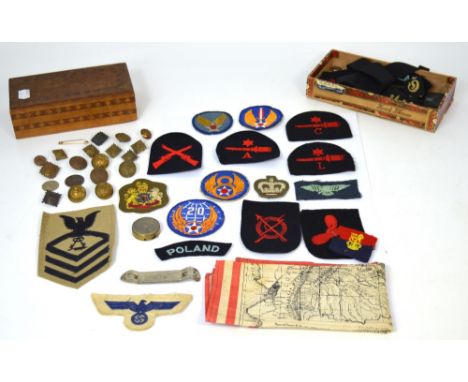
Lot 500
A quantity of military badges to include Naval badges, German badges and a Naval hat ribbon for the Schlachtschiff Scharnhorst ship, a quantity of military buttons to include examples form the king's regiment, a small brass compass, and a small linen map 'Mapa de la Region Amazonica Del Peru'.
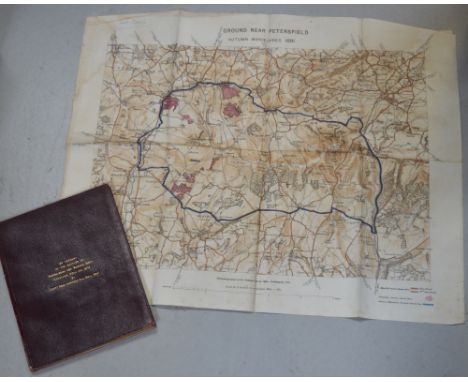
Lot 487
A leather bound account of the battles of Isandlwana and Rorke's Drift, Zululand, 22nd January 1879, by Captn. Penn Symons, 2nd 24th Regt. The account details the battles of Isandlwana and Rorke's Drift from a first hand perspective and subsequently from the few remaining survivors of both battles who are included in the list of survivors of 1/24th Regt; Pte. Williams, groom to Col. Glynn, Pte. Bickley, band member, Pte. Wilson, band member, Pte. Trainer, rocket battery, Pte. Johnson, rocket battery, Pte. Grant, mounted infantry and officers who escaped to include; Capt. Essex 75 Regt., Capt. Gardener, 14th Hussars, Lieut. Cachrane 32 Regt. Lieut. Smith Dorrien, 95th Regt and Lieut. Curling R.A. William Penn Symons (July 1843- October 1899) was a British army officer who lost his life at the battle of Talana Hill during the second Boer war. His first combat was in South Africa during the 9th Xhosa war (1877-78). In 1879 he took part in the Zulu wars which this book documents, the merest chance saved him form death at Isandlwana, also a linen map 'Ground near Petersfield Autumn Maneuvers 1891'. As photozincographed at the Ordnance Survey Office Southampton, 1891. CONDITION REPORT This is a private publication, there are 63 pages.


Lot 1434
PATERSON'S BRITISH ITINERARY . . . the Direct and Principal Cross Roads of Great Britain. 2nd edition improved, 2 vols. double-page general map & 87 leaves of strip road maps (in 386 numbered columns), engraved titles & explanatory letter-press; contemp. calf (distressed). Bowles & Carver, 1807.


Lot 1471
James WYLD - A Map to Illustrate the War in China: compiled from surveys & sketches of British officers . . . 2nd edition. outline colour, 33 x 73cms., 5 insets, folded & mounted on linen, & in original patterned cloth slipcase. (1842). * a detailed map; insets include attacks on Canton & Amoy by British forces - & at the latter, names & stations of warships. Illustrated

Lot 1469
DINSMORE'S Complete Map of the Railroads & Canals in the United States & Canada . . . 65 x 79cms., coloured in outline, engraved title, inset area map, folded on paper into decorated cloth covers. New York, 1856; sold with Wm. Darton's small map of South America (1820), in slipcase; & 3 others. (5)


Lot 1478
Don Thomas LOPEZ - Map of Spain & Portugal . . . 43 x 54cms., hand-coloured in outline, engraved title, folded & mounted on linen, in original slipcase with printed paper label. John Stockdale, 1808; sold with A New Map of Europe (folded, Wm. Darton, 1829, in slipcase); & 2 later maps of Crete. (4)

Lot 1468A
WRIGHT (T.) The Universal Pronouncing Dictionary . . . 5 vols. with num. engraved portraits, plates, & the series of 79 d-page Tallis maps (outline colour); half calf & marbled boards, 4to. (?1850). * the map by Rapkin, with the attractive engraved vignette border illustrations, & 'forming a complete atlas of the world'.

Lot 1482
Thomas HAM - A Map of Australia Felix . . . 48 x 73cms., outline colour, engraved title & references, inset area map, folded on linen into old covers. Melbourne, 1847. * includes the very rare 15pp. key (with numbered squatting districts); 'compiled & carefully revised from the Colonial Government Surveys, Crown Lands Commissioner's & Explorers Maps, Private Surveys, &c.' Illustrated


Lot 1476
James WYLD - Map of the country between Odessa, and Constantinople, embracing the present Seat of War, between the Russians & Turks. 77 x 50cms., hand-coloured, engraved title, insets of Bosphorus, Dardanelles, & another, folded & mounted on linen, within cloth covers. (ca. 1855); John ARROWSMITH The Crimea . . . 52 x 67cms., outline colour, some engraved text, insets of Sebastopol & Black Sea, folded & mounted on linen in cloth slipcase with paper label. 1854.
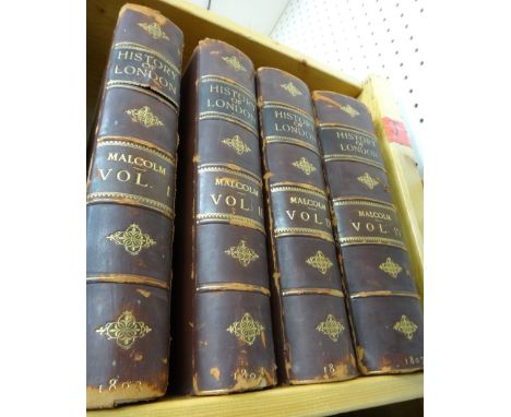
Lot 1345
MALCOLM (J.P.) Londinium Redivivum; or, an Antient History and Modern Description of London . . . First Edition, 4 vols. 46 engraved plates; early 20th cent. half calf & cloth, gilt spine, 4to. 1802-07. * EXTRA-ILLUSTRATED with addition of some 380 plates, num. folded & a few hand-coloured (see internet details); also Stockdale's large-scale 'A New Map of the Country Round London' (1796), hand-coloured & folded.Add 255

Lot 1474
Ulrich HENDSCHEL - Post Reise Karte von Deutschland . . . 105 x 126cms., outline colour, engraved title, coloured key, inset area map shows part of Poland, part of Italy, much of France etc. folded & mounted on linen, in original paper slipcase with printed labels. Frankfurt, 1843; James WYLD New Map of the Rhine (i.e. Panorama). 123 x 32cms., coloured in outline, engraved title & references, folded & mounted on linen, in cloth covers with paper label. 1838.
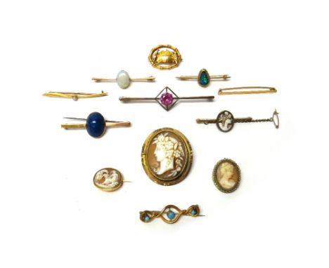
Lot 2211
A gold bar brooch, claw set with an oval opal, a gold bar brooch, mounted with a seed pearl at the centre, detailed 18 CT, a gold oval brooch, detailed with a map of Australia, five mostly gem set bar brooches and pins, a Victorian gilt metal mounted oval shell cameo brooch, carved as the portrait of a classical lady and three further cameo brooches, (12).

Lot 1479
J. RENNELL - Hindoostan. 81 x 82cms., hand-coloured in outline; large medallion pictorial & allegorical title, engraved scale bars; folded & mounted on linen. 1782. * shows whole of the sub-continent, & parts of Afghanistan, Tibet, Burma, Siam etc.; the subject of Rennell's 'Memoir of a map of Hindoostan . . . (1782). Illustrated


Lot 314
John Andrews (1736-1809), Andrew Drury and William Herbert - Pair of coloured engravings - Plate 9 "Whitstable" and Plate 20 "Dover", from "A Topographical Map of the County of Kent in Twenty Five Sheets on a Scale of Two Inches to a Mile from an Actual Survey...", published January 1st 1769, each 17.5ins x 26ins, framed and glazed


Lot 500
JAMES BOND 1:8 SCALE ASTON MARTIN; A large and heavy quality 1:8 scale Eaglemoss diecast precision model of James Bond's Aston Martin DB5. Highly detailed, the original spec for the model includes; working rear and front lights, working horn, ejector seat, accelerator sound effects, brake lights, light up map to interior, machine guns in lights, movable bullet proof rear screen, key ignition, rubber tyres etc. This particular model is well made. Just one of the features is not working (accelerator), but on the whole this is in fantastic condition. Comes with a custom made glass and wooden display case and plinth, and original magazines 56cm long, approx 8.5kg. CAN BE POSTED WORLDWIDE CONTACT US FOR A QUOTE, OR VIEW www.eastbristol.co.uk.
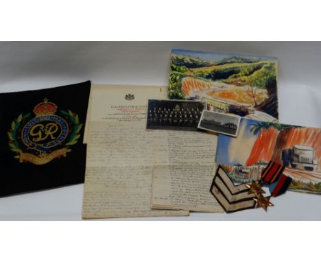
Lot 287
MILITARY MEDALS & INTERESTING ITEMS RELATING TO S/SGT. CHARLES ROEBUCK of the Royal Engineers and including a 1939-1945 Defence Medal with oak leaf, 1939-1945 Star, The Burma Star, a Burma Star Association pin, military paperwork, copy of relevant London Gazette sent On His Majesty's Service and complete with envelope and letter, a folding map of India and Assam, watercolour sketches of Burma, a Royal Engineers needlework sampler etc. Typed on both sides of eight A-5 lined sheets, an interesting log of air raids in the Cardiff and South Wales / West Wales area in 1939 / 1940, notes location and impact. It details the devastating, and infamous, bombing - on Monday, August 19, 1940 - when three Luftwaffe planes took aim at Admiralty oil tanks, holding millions of gallons of vital fuel, above Pembroke Dock. The resulting inferno raged for 18 days. The entry begins: '3.15 p.m. having tea when heard sound of bombs exploding - about 6-8, also whistling bombs. Then sound of planes - very loud - passing overhead. Prep. Take cover. Action over in about 12-15 secs. Saw huge clouds of smoke S.W. Pembroke. Went to top of Defensible Barracks Hill and saw Oil Tanks blazing - flames 100-200 ft. high and enormous clouds of smoke.' Of the 18 tanks at the Llanreath Oil Tank Depot, 11 were destroyed and 33 million gallons of oil lost before the flames were eventually extinguished in September 1940. More than 22 brigades and 650 men from across the UK were needed to quell the blaze which caused five from Cardiff to lose their lives. Provenance: Charles Roebuck was the step-father of our vendor, please also see Lot Number 271 in this sale


Lot 1875
Wilson, Horace Hayman. Ariana Antiqua. A Descriptive Account of the Antiquities and Coins of Afghanistan, first edition, 36 lithographed plates, large folding engraved map, some light spotting, later plates waterstained, lower left, 4pp. list of subscribers, 3pp. list of author's works at end, original cloth, neatly rebacked, bookplate of Bath Public Reference Library, occasional blindstamps throughout, 4to, London: East India Company, 1841
Lot 2060
Weber, Christian Friedrich. The Present State of Russia, 2 volumes, first English edition, large folding engraved map, torn, large folding plan of St. Petersburg, torn and repaired, some spotting and soiling, contemporary panelled calf, joints slightly cracked, rubbed, bookplate of Bath Public Reference Library, occasional blindstamps throughout, 8vo, London: W. Taylor, 1722-23
Lot 2054
Strahenlenberg, Philip Johann von. An Historico-Geographical Description of the North and Eastern Parts of Europe and Asia; but more particularly of Russia, Siberia, and Great Tartary, first English edition, 8 [?of 10] engraved plates, including 3 folding, folding table 'Harmonialinguarum', folding woodcut map 'Tab. XIX', 8pp. of large woodcuts in text, lacking large folding map, title soiled, some rust-marks, contemporary calf, rubbed, neatly rebacked, bookplate of Bath Public Reference Library, occasional blindstamps throughout, 4to, London: W. Innys, 1738

Lot 2022
[Dameto, Juan] The Antient and Modern History of the Balearick Islands; or of the Kingdom of Majorca... translated from the Original Spanish [by Colin Campbell], first English edition, folding engraved map, title soiled, rather spotted throughout, contemporary calf, neatly rebacked, bookplate of Bath Public Reference Library, occasional blindstamps throughout, 8vo, London: William Innys, 1716 This copy would seem to lack a folding map.
Lot 2083
Ogilby, John. The Roads from Exeter com. Devon to Dorchester and from Plimouth to Dartmouth, engraved strip map, hand-coloured in outline, 455mm x 320mm, [c.1676]; The Road from Oxford to Chicester, engraved strip map, hand-coloured in outline, 427mm x 350mm, [c.1676], both framed and glazed (2)
-
108737 item(s)/page