We found 109198 price guide item(s) matching your search
There are 109198 lots that match your search criteria. Subscribe now to get instant access to the full price guide service.
Click here to subscribe- List
- Grid
-
109198 item(s)/page


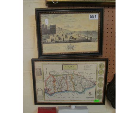

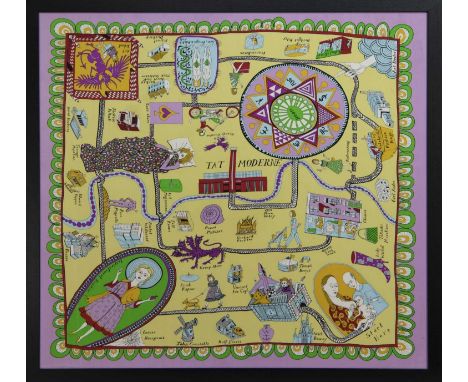
Lot 637
* GRAYSON PERRY RA (BRITISH b. 1960),100% SILK SCARF100% silk, produced for the Tateimage size 91cm x 88cm, overall size 95.5cm x 95.5cm Framed and under glass.Note: In the second world war pilots were given maps printed on silk to help them escape if they were shot down over enemy territory. This scarf is a social and cultural map to help aspiring artists navigate the hostile territory on their way to being accepted by the establishment. Many famous artists who can help them live along the route.


![A 17th century Hungaria map. [16.5x21cm]](https://cdn.globalauctionplatform.com/2e4acb57-e3ee-4854-815e-adc200b76be6/311cd56b-305f-43dd-942b-adc20113edbe/468x382.jpg)
![John CareyAntique map of Cumberland. [Frame- 45x39cm]](https://cdn.globalauctionplatform.com/2e4acb57-e3ee-4854-815e-adc200b76be6/cf0a89c2-caa3-44d0-ac52-adc2011a8fd3/468x382.jpg)


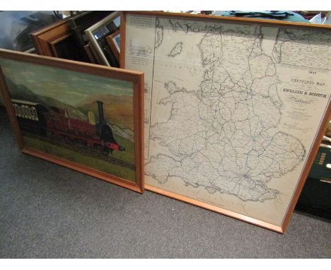
Lot 1135
A Henry Teesdale fold out Map of the world "A New Chart of the World on Meractor's Projection with the Tracks of the Most Celebrated and Recant Navigators, 1845. Engraved by John Dower, laid on linen and displayed on two folding sheets, bound in contemporary maroon Morocco boards, 78'' x 52'' approx.


Lot 1221
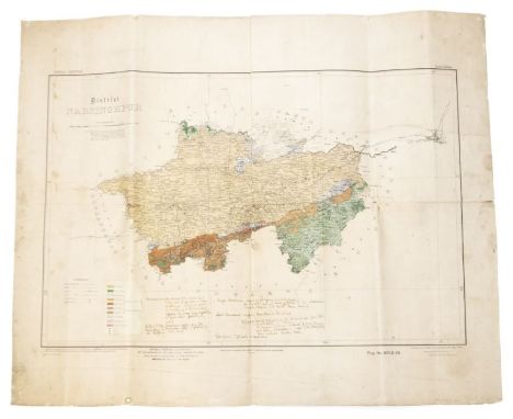
A quantity of Royal Commission on Vaccination 1889 -1897 reports (five) and three appendices with diagrams and maps etc including large scale map of Warrington 1893, 12'' to 1 mile, 26'' x 38'' with nine smaller maps showing progress of Smallpox infections 1892 to 1893 and a large map of Leicester Town, 6'' to 1 mile, showing areas infected by Smallpox 1892 -93.


Lot 168
David Garrick's copy.- King (Daniel) The Vale-Royall of England. Or, The County Palatine of Chester... also, An Excellent Discourse of Island of Man, first edition, engraved additional title (trimmed to margin and laid down), double-page maps of Cheshire & The Isle of Man, double-page plan of Chester, 11 plates of Arms and 5 other folding or full-page plates, engraved illustrations, letterpress title rather soiled, backed with 1 letter restored, 1 double-page map and the plan with splitting along central fold, 1 plate trimmed, affecting caption at foot, occasional short marginal repaired tears, occasional soiling, damp-staining towards end, bookplate to pastedown, attractive 18th century red morocco, gilt, spine gilt in compartments with Greek key design and urn motif, g.e., [Wing K488], sm. folio, by John Streater, 1656.⁂ The work was in fact written by William Smith, William Webb and Samuel Lee, and the part devoted to the Isle of Man by James Chaloner. King only wrote the dedication and was the engraver of the plates.Provenance: David Garrick (his gilt initial "D" headed by eagle to foot of spine).
Lot 374
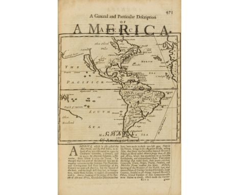
World.- Moll (Herman) Thesaurus Geographicus, A New Body of Geography, or a Compleat Description of the Earth, first edition, 58 engraved maps and plans, comprising 2 full-page and 56 printed within the text (24 maps and charts, 32 plans of fortified towns), including map of American with California as an island, pagination and collation erratic but seemingly complete, 2S4 torn at head running into text, last 2 ff. with loss to upper margin affecting a few words of text, occasional light browning, the odd marginal tear, a few ff. fore-margin a little creased and frayed, bookplate to title verso, ink ownership inscriptions to pastedowns, contemporary panelled calf, some chipping to spine ends, rubbed, [Wing T869], folio, for Abel Swall, 1695.⁂ Provenance: John Hogg, Lincoln's Inn (bookplate and inscription).
Lot 375
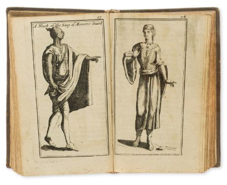
Morocco.- Pidou de Saint Olon (François) Present State of the Empire of Morocco; With a faithful account of the manners, religion, and government of that people, first edition in English, engraved frontispiece, folding map and 8 plates of costumes, occasional browning but a good copy generally, book label and ink inscription to pastedown, contemporary speckled calf, upper joint cracked but holding firm, chip to head of spine, [Wing P2159], 8vo, by R. Bentley, 1695.⁂ Pidou de Saint Olon led a 1693 embassy to the Sultan of Morocco in the hopes of securing a treaty. The mission was unsuccessful and returned after only a month. Provenance: Wiston Old Rectory (book label); Reynold and Janet Stone (ink inscription "Found and given to Janet Stone by her husband Reynolds in memory of a stay in Morocco March 1970").

Lot 225
Levant.- Sandys (George) Sandys Travells, containing an history of the Original and present State of the Turkish Empire... Of Ægypt... A Description of the Holy-Land... Lastly, Italy, sixth edition, engraved additional title (margins a little browned), double-page map (some ink staining to centre), small folding view, numerous illustrations to text, G2 tear to head running into text, occasional light marginal soiling, but a good copy generally, modern antique-style speckled calf, [Wing S679], folio, for Rob. Clavel, 1670.
Lot 52
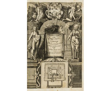
Leicestershire.- Burton (William) The Description of Leicester Shire, containing Matters of Antiquitye, Historye, Armorye, and Genealogy, engraved pictorial title (neatly trimmed to margins and window-mounted), engraved portrait frontispiece, folding map by C. Saxton (neatly mounted on stub, stain to lower corner), woodcut coats of arms in text, first 2ff. of text a little soiled with small portion of restoration to head, ink notes in a contemporary hand extending genealogical tables, occasionally to margins and adding 3pp. of index to rear endpapers, bookplate to pastedown, olive calf gilt by Zaehnsdorf, light rubbing and fading to spine, g.e., [STC 4179], folio, for John White, [1622].
Lot 11
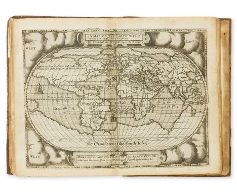
Hondius map.- Broughton (Hugh) A Concent of Scripture, first edition, first issue, engraved title with wording "Come, and see" at top, woodcut initials and decorations, double-page engraved map of the world attributed to Jodocus Hondius the elder, 5 engraved plates, without the folding map of Judea ("north part of the equinoctial") and folding letterpress explanation as often, later panelled calf, gilt, with gilt arms to upper cover, rebacked, rubbed, one corner worn, [STC 3850], 4to, for Gabriell Simson and William White, [1587-91].⁂ A very good copy of this work, in essence a chronology of scriptural history, by Broughton (1549-1612), a divine and rabbinical scholar. It was seen through the press by John Speed. Ben Jonson satirised the author in Volpone and The Alchemist; and Sir John Harington mentions the work in his 'advertisement' to his translation of Orlando Furioso: "..a treatise set foorth by Maister Broughton, the last year, upon the Revelation, in which there are some 3 or 4 pretie figures (in octavo) cut in brasse verie workemanly."This is the first major work of cartographer Hondius (1563-1612/3), who came to England in 1583 as a Protestant refugee. The map of the world is based on Ortelius; the missing map is found in very few copies and the leaf of letterpress by R. Field, dated to c.1590, may represent a later issue. This copy has the chain lines in gathering F horizontal, denoting a first issue.Provenance: Henry Villiers Stuart, Baron Stuart de Decies (1803-74) - his arms on upper cover. Bookplate of Tempsford Hall; ink stamp of Bradford City Library to rear pastedown.
Lot 245
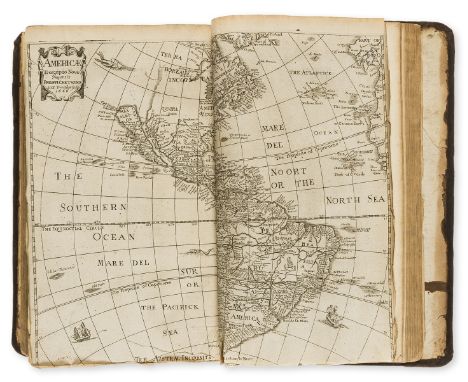
World.- Heylyn (Peter) Cosmography in Four Books. Containing the Chorography and History of the Whole World, 4 parts in 1 vol., engraved additional title dated 1670, 4 double-page engraved maps of Europe, Asia, Africa, and America, with initial imprimatur f., map of America with fraying to margins and short tear to foot, hole to third T1, with loss to a few letters of text, the odd marginal chip or tear, occasional light worming to margins, some light toning, but a good copy generally, ink ownership inscription to head of engraved title, contemporary calf, rebacked and recornered, some surface wear, [Sabin 31655; Wing H1694], folio, for Anne Seile, and Philip Chetwind, 1674.⁂ Provenance: Robert Foulkes (ink inscription).
Lot 323
Staffordshire.- Plot (Robert) The Natural History of Stafford-shire, first edition, title with engraved vignette, engraved folding map, 37 engraved plates by Burghers, 26 double-page (mostly houses), 4pp. list of subscribers at end, lacking the "Armes Omitted" plate (as often), gathering A working loose, a few plates with marginal repairs or neatly repaired tears, one double-page view with tear running into image, occasional light marginal staining or soiling, bookplate to title verso, bookplate to pastedown, contemporary calf, joints cracked, corners bumped, rubbed and scuffed, [Wing P2588], folio, Oxford, Printed at the Theater, 1686⁂ With two chapters on minerals and stones, including fossils; by the first keeper of the Ashmolean Museum.Provenance: Bridgman family; J. Fairfax Best (bookplates).
Lot 232
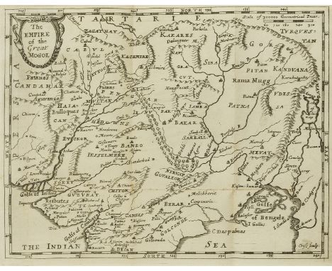
India.- Bernier (Francois) The History of the Late Revolution of the Empire of the Great Mogol: together with the Most Considerable Passages for 5 Years Following in that Empire, translated by Henry Oldenburg, 2 parts in 1 vol., first edition in English, folding engraved map at end, title within double-rule border, woodcut initials, title browned at head, but a good, clean copy otherwise, bookplate to pastedown, hinges weak, contemporary sheep, some light wear to extremities, [Wing B2043], small 8vo, sold by Moses Pitt at the White Hart in Little Brittain, 1671.⁂ Scarce, with a section on Kashmir and map at the end covering the Indian peninsula as far south as Golconda.Provenance: Fintray House Library (bookplate).

Lot 255
Faroe Islands.- Debes (Lucas Jacobsen) Faeroae, & Faeroa Reserata: that is a Description of the Islands & Inhabitants of Foeroe, first edition in English, translated by J[ohn] S[terpin], folding engraved map and plate (both slightly repaired), woodcut illustration, foxing and browning, a few marginal defects, title and following leaf with minor worm-hole (touching ruled border but no text), contemporary calf, rubbed and repaired, [Wing D511], 12mo, Printed by F.L. for William Iles, 1676.⁂ Comprehensive account of the Faroes including history, geography, natural history, religion, weather, whaling, fishing and other resources. It mentions the discovery of a quantity of herrings on top of the mountain of Kolter, attributing this phenomenon to a "whirlewind", which "in some places rain down Stones, Flesh, Mice, and particularly the Lemmings or Cats of Norway."


![JOHN SPEED: DENBIGHSHIRE, engraved hand coloured map [1611], approx 380 x 510mm, framed and glazed](https://cdn.globalauctionplatform.com/e9790c41-c947-402e-ad16-adbb00e6d97a/315d952f-6e79-42ce-a5eb-adc0011c6746/468x382.jpg)

![ROBERT MORDEN: THE EAST RIDING OF YORKSHIRE, engraved hand coloured map [1695], approx 355 x 420mm, framed and glazed](https://cdn.globalauctionplatform.com/e9790c41-c947-402e-ad16-adbb00e6d97a/5b0d9805-696b-48f0-afb0-adc0011c6a58/468x382.jpg)
![ROBERT MORDEN: ENGLAND, engraved hand coloured map [1695], approx 355 x 420mm, framed and glazed](https://cdn.globalauctionplatform.com/e9790c41-c947-402e-ad16-adbb00e6d97a/f576c3d1-6703-4474-9830-adc0011c6b70/468x382.jpg)

-
109198 item(s)/page