We found 109198 price guide item(s) matching your search
There are 109198 lots that match your search criteria. Subscribe now to get instant access to the full price guide service.
Click here to subscribe- List
- Grid
-
109198 item(s)/page


Lot 394
A vintage G W Golding sale poster, Saturday 15th September 1923 at the Westgate Estate sale room Grantham for Colsterworth valuable freehold property, 73cm x 52cm, map showing the alteration of the areas of parishes of Barrowby, Harlaxton, etc., an advertising poster for St. John passion by Barch at Grantham, local posters, etc., for the foundations Stone Lane 1906 New Somerby, another, various other maps, Grundy and Warwick auction sale poster, etc. (a quantity, some AF)


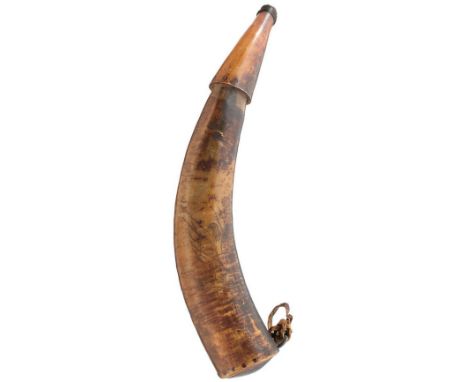
Lot 118
AN 18TH CENTURY POWDER HORN OF AMERICAN INTEREST, the 43cm body finely decorated with a map of the Connecticut River, the left bank with the named elements MHR, Hadham, Wedding Br. Middletown, Middleton Br. Dividend Br. Glafses Br. Robins Br. Hertford, Windlop, Hentons Br. Springfield, Fishing Falls, Hampton Upper Falls, the right bank with the named elements, Dick R. East Windsor, Scantick Br. Saltroustall Br. Enfield, Fresh Water, Long Meadow Br. Long Meadow Meeting Hse. Mill R. Springfield Meeting Hse. Chiathee R. New Hadley Meeting Hse. Hadley Hankanum, further decorated with the Harp of Erin flanked by G and R and surmounted with a crown, the motto beneath Nec Aspera Terrent, the base and upper nozzle secured with multiple tiny wooden dowels, retains a small portion of the hide suspension strap.
![F. Lion Cachet Amsterdam: Hoveker & Wormser, [1898] THIRD EDITION, 8vo, viii + 660 pp, 6 plates and one folding map, original](https://cdn.globalauctionplatform.com/525caa29-f8db-4809-ac5b-abfa00886da0/bd18d305-f39f-45d3-8df9-abfa00a250c9/468x382.jpg)
Lot 143
F. Lion Cachet Amsterdam: Hoveker & Wormser, [1898] THIRD EDITION, 8vo, viii + 660 pp, 6 plates and one folding map, original pictorial cloth, boards worn with stains on back and corners bumped, first few pages loose but not detached, textblock and pages edges lightly tanned, small stain on back of map and facing page, 25cm tear starting diagonally from hinge and then along fold, small holes along outside edge of map, ex-library with stamps on three pages, Frikkie Botha bookplatePROVENANCEThe library of the late J S F (Frikkie) Botha
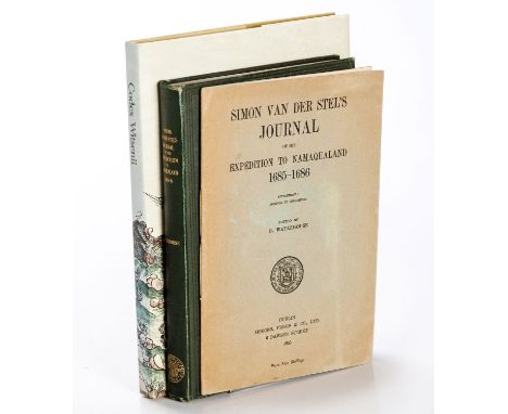
Lot 150
G Waterhouse (ed) London: Longmans, Green, and Co, 1932 (Dublin University Press Series) FIRST EDITION, large 8vo, xxviii + 183 pp, 44 plates + 1 map, large 4to, original green cloth, dust jacket absent, very light wear on edges, corners and hinges, small section of paste down lifting off inside hinge, free ep tanned, Frikkie Botha bookplate and SIMON VAN DER STEL’S JOURNAL OF HIS EXPEDITION TO NAMAQUALAND, 1685-6: SUPPLEMENT: ADDENDA ET CORRIGENDA by G Waterhouse (ed) Dublin: Hodges, Figgs & Co, 1953 Large 8vo, iv + 19 pp, frontis, original stitched green wraps, wraps tanned, Frikkie Botha bookplate, flattened fold in back wrap and CODEX WITSENII by M L Wilson, Toussaint van Hove-Exalto & WJJ van Rijssen (eds) Cape Town: Iziko Museums, 2002 4to, 190 pp, frontis + 69 plate + 1 map, original faux vellum, dust jacket, inscription on ep (3)PROVENANCEThe library of the late J S F (Frikkie) Botha
Lot 151
Rev John Campbell London: Black, Parry & Co, 1815 THIRD EDITION, CORRECTED, 8vo, xvi + 400 pp, frontis + 8 plates of which one folds out + one fold out map, half morocco and blue cloth, mild tanning throughout, map with one 4cm repaired tear along fold and 6cm repaired tear from hinge, one page with 2cm tearPROVENANCEThe library of the late J S F (Frikkie) Botha
![Rev W Ellis New York: Harper & Bros, 1859 8vo, [xv] + [2] + 18 - 514 + [2] ad pp, one map + double page frontis + 15 plates,](https://cdn.globalauctionplatform.com/525caa29-f8db-4809-ac5b-abfa00886da0/961f78dd-7eb3-4f38-96a5-abfa00a259e0/468x382.jpg)
Lot 152
Rev W Ellis New York: Harper & Bros, 1859 8vo, [xv] + [2] + 18 - 514 + [2] ad pp, one map + double page frontis + 15 plates, original gilt pictorial cloth, new eps, name of previous owner on title page, very light foxing throughout and on edge of text block, Brodart cover, Frikkie Botha bookplatePROVENANCEThe library of the late J S F (Frikkie) Botha
Lot 154
Full Title: NARRATIVE OF AN EXPEDITION TO THE ZAMBESI & ITS TRIBUTARIES; AND OF THE DISCOVERY OF THE LAKES SHIRWA AND NYASSA. 1858-1864David & CharlesNew York: Harper & Bros, 1866 FIRST AMERICAN EDITION, 8vo, xxii + 638 + 6 catalogue pp, double page frontis + 12 plates and numerous in-text illustrations + one large fold out map, original brown cloth with Brodart cover, boards show some wear, loss of foot and head cap of spine, hinge cracked at top 4cm of front and back, back internal hinge cracked, few small holes in hinges, inscription to previous owner on ep, heavy tanning from newspaper cutting on two pages, last 80 pages lightly tanned, map with 2cm repaired tear at hinge, Frikkie Botha bookplatePROVENANCEThe library of the late J S F (Frikkie) Botha
![Giovanni Magini & Girolamo (Hieronymus) Porro[Florence: Francesco Tosi, (1592) 1595]Woodblock, two leaf map, tanning and ligh](https://cdn.globalauctionplatform.com/525caa29-f8db-4809-ac5b-abfa00886da0/8da776d5-ba7f-4857-93a8-abfa009c2f03/468x382.jpg)
Lot 197
Giovanni Magini & Girolamo (Hieronymus) Porro[Florence: Francesco Tosi, (1592) 1595]Woodblock, two leaf map, tanning and light soiling in bottom margin, pencilled number in corner, 6 pages in total, 140 at top left, 141 at top right; verso: Italian text titled 'Del Mondo E Sue Parti'from Rosaccio's "Il mondo e sue parti cioe Europa, Affrica, Asia, et America"12,5 by 17,7cm (two leaves: 20,5 by 16cm)
![Barent Langenes[Padua: Giovanni Battista Conzatti, (1596) 1713]Copperplate, map portion of leaf only, light tanning within pl](https://cdn.globalauctionplatform.com/525caa29-f8db-4809-ac5b-abfa00886da0/82838232-b7ab-438b-b12b-abfa009c1386/468x382.jpg)
Lot 198
Barent Langenes[Padua: Giovanni Battista Conzatti, (1596) 1713]Copperplate, map portion of leaf only, light tanning within plate mark, upper left corner outside plate mark repaired, dark small foxing spot below title, foxing spot in right margin, fading of small text, pencilled number in corner; verso: three columns of Latin text, remains of tape in top margin with two lines of text obscuredfrom Raphael Savonarola's Univerus Terrarum Orbis Scriptorum12,6 by 17,4cm (leaf: 15,3 by 20,7cm)
![Pierre Du Val[Paris, (1663) early or first state] Copperplate, hand colour in outline, age toned except for light stripe alon](https://cdn.globalauctionplatform.com/525caa29-f8db-4809-ac5b-abfa00886da0/be8d0bf2-86cc-4031-9189-abfa009c0ac0/468x382.jpg)
Lot 202
Pierre Du Val[Paris, (1663) early or first state] Copperplate, hand colour in outline, age toned except for light stripe along fold line, map in display frame and top attached in two places to backing with tape, margins lighter toned under window mount, pencilled number in corner; verso: darker aged toned within neat line rectangle, paint show through, pencilled notes from Du Val's Le monde ou La géographie universelle 10,2 by 12,5cm (leaf: 16,2 by 18,4cm) Early state indicated by the absence of Table Bay and Agulhas Bank.as Bank.
Lot 205
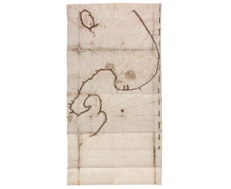
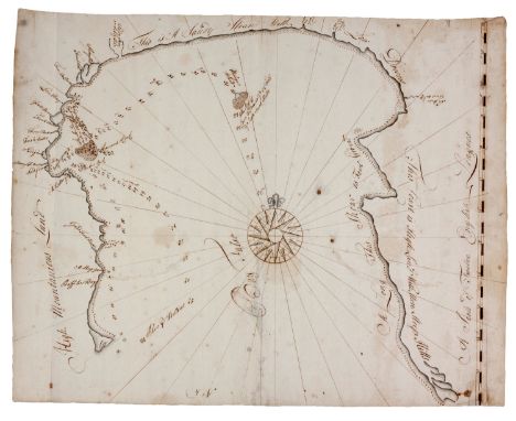
Ink and watercolour on laid paper with backing, three sheets of paper as originally combined with overlap, one sheet watermarked with Strasburg Bend and Lily (shield with two diagonal bands surmounted by a fleur-de-lis) and counter marked with “IV”, and another sheet with letters “LVG” below Strasburg Bend and Lily and “IV”; map edges unevenly trimmed, nine horizontal and three vertical folds (assuming top of chart is North), modern repairs on verso, repaired damage at fold crossings, soiling along three fold lines, repair of 7cm closed tear on edge of map, repair measuring 6 by 5cm obscuring scale, paper pulling away from backing in narrow strips along edges in a few places, 14cm tear in blank margin, extension of coast in pencil Verso with ‘No 9’ in contemporary ink; neat lines to south and east sides of map, latitude scale along eastern neat line marked at one place with “34 Degs S”, rhumb lines, fleur-de-lis indicating north, pin prick in center of rhumb line crossings, hydrographic detail includes soundings, shipping hazards and safe anchorages; land based detail include a few place names on the coast such as The Castle of Good Hope, a battery, fresh water sources, and descriptions of topography and terrain along coast approximately 93 (105 with margin) by 59cm ENGLISH CHARTS OF DUTCH ORIGIN These manuscript charts are part of an important moment in cartography. During the seventeenth century the Dutch completely dominated the world chart trade. John Seller published his English Pilot in 1671, in part a response to this affront to the pride of the sea-faring British and in part a sound financial decision. However, his atlas still relied on Dutch charts, as Samuel Pepys’ remarked: “…he says that he knows it to be true and Seller will not deny it, that he bought the old worn Dutch copper plates for old copper, and had them refreshed in several places, and has used them in his pretended new book.” Although Seller eventually lost his business, other publishers continued to issue The English Pilot until 1794. According to Stewart (2016) the charts of the Cape of Good Hope used in these editions were most likely that of John Thornton or the second state of Seller’s map. Thornton redrew the Seller’s map in 1703 and made changes, the most significant in relation to Lot 207 is the use of Coney Island instead of Dassen Island. This can be regarded as a case of colonization-by-map, since there was a practice of renaming topographic features with English names. This was already the case with Robben Island that was referred to as Penguin Island on Thornton maps – both these toponyms are used on the map in Lot 207. Also, the third state of Thornton’s map published in 1734 used “Bay of Falzo”, a close match to “Bay Falso” of Lot 206. However, these links may be only speculative and it may not be possible to divine the specific destination of the manuscript maps and the information they contain, however the original source of these maps may be ones held in the Dutch National archive. Four manuscript charts, circa 1730, closely match the charts on offer. The first is Kaart van de Tafel- en Houtbaay (VEL0182) and the second is Kaart van de Baai Fals (VEL0187), both by Isaak van Es. The cartographer of the Robben Island (VEL0194) and Dassen Island (VEL0191) charts is not identified, but these are also associated with the VOC. In fact all four charts appear in Grote Atlas van de Oost-Indische Compagnie (Schilder, G et al: 2006). On all four charts on offer the soundings and other maritime details are closely matched to those on the Dutch maps. In addition, the coastlines, and more significantly the mountain profiles are similar. The manuscript charts can be placed within an important era of cartography in southern Africa, and information can be found of their origin and possible purpose. However, their charm lies in the mysteries surrounding them and the tantalizing clues that may reveal their secrets. REFERENCES Shirley, Rodney W. The Maritime Maps and Atlases of Seller, Thornton, and Mount & Page, The Map Collector 73:2-9, 1995. Stewart, Roger. The Cape Odyssey 107. Cape Town: Historical Media, 2016.
Lot 206
Ink and watercolour on laid paper with backing, paper watermarked with Strasburg Bend and Lily (shield with two diagonal bands surmounted by fleur-de-lis) and counter marked with “IV”, map edges unevenly trimmed, three vertical folds (assuming top of chart is North), modern repairs to ends of fold lines, small tears to edges, some damp marks, tanning and foxing, grey discolouration along half of one fold; verso: ink show through Recto and verso with ‘No 4’ in contemporary ink, one neat line on east side of map, scale in English leagues, rhumb lines, compass rose with fleur-de-lis indicating north, pin prick in center of compass rose, hydrographic detail includes soundings, shipping hazards and safe anchorages; land based detail include a few place names on the coast, a battery, fresh water sources, and profiles and descriptions of topography and terrain along coast approximately 47 by 57cm Refer to Lot 205 for additional background on the manuscript maps.
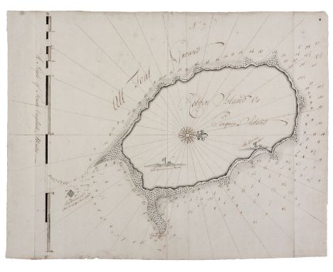
Lot 207
ROBBEN ISLAND OR PENGUIN ISLAND Ink and watercolour on laid paper with backing, paper watermarked with Strasburg Bend and Lily (shield with two diagonal bands surmounted by fleur-de-lis) above letters “LVG” and counter marked with “IV”, map edges unevenly trimmed, three vertical fold lines, modern repairs to fold lines, light soiling to edges Recto and verso with ‘No 7’ in contemporary ink, map oriented with north to the right, neat line on left side, scale in English miles, rhumb lines, compass rose with fleur-de-lis indicating north, hydrographic detail includes soundings and shipping hazards; small sketches of The Governor’s House and The Watchman’s House with flags approximately 53 (60 with margin) by 46 cm WEESSELS ISLAND OR CUNNY ISLAND [DASSEN ISLAND] Ink and watercolour on laid paper with backing, map edges unevenly trimmed, three vertical and one horizontal fold lines, pin pricks in rhumb line crossings, some damp marks with foxing on one edge, few spots of soiling Recto and verso with ‘No 6’ in contemporary ink, map oriented with north to the right, neat line on left side with rhumb lines continuing into margin, bar scale without units, fleur-de-lis indicating north, hydrographic detail includes soundings, shipping hazards and safe anchorage, two land based features identified, one with a watercolour profile approximately 53 by 64cm (2) Refer to Lot 205 for additional background on the manuscript maps.

Lot 445
A FRAMED MICHELIN MAP OF THE BRITISH ISLES NUMBER 6 depicting the route from Glasgow to Edinburgh, the map 113cm x 46cm unfolded, detached from cover and set within a black frame, the frame 123cm x 57.8cm overall At present, there is no condition report prepared for this lot This in no way indicates a good condition Please contact the saleroom for a full condition report
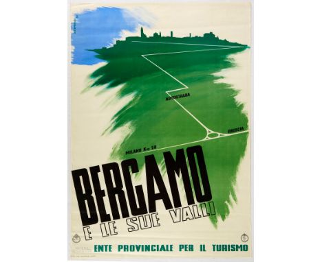
Lot 12
Original vintage travel poster for Bergamo and its Valleys issued by ENITprovincial body of tourism. Great Modernist design depicts a green city skyline with a map route marked with Milano, Autostrada and Brescia. Bold lettering appears below. Good condition, creasing, light staining. Country of issue: Italy, designer: Diego Santambrogio, size (cm): 100x68, year of printing: 1938
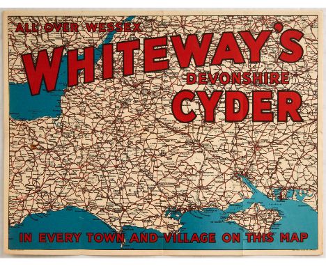
Lot 124
Original vintage advertising poster issued by the Whiteways Devonshire Cyder all over Wessex in every town and village on this map. Poster features a map of Wessex. The Whiteway family have made cider in Devonshire for generations and exported thousands of gallons of cider to America during the post-prohibition era. At the peak of production the apple orchards at Whimple were the most extensive in the world. The company ceased production in 1985 due to decline in sales. Good condition, folded as issued, light staining. Country of issue: UK, designer: Unknown, size (cm): 30.5x40.5, year of printing: 1930s
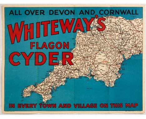
Lot 125
Original vintage advertising poster issued by the Whiteways Flagon Cyder all over Devon and Cornwall in every town village on this map. Poster features a map of Devon and Cornwall. The Whiteway family have made cider in Devonshire for generations and exported thousands of gallons of cider to America during the post-prohibition era. At the peak of production the apple orchards at Whimple were the most extensive in the world. The company ceased production in 1985 due to decline in sales. Good condition, folded as issued. Country of issue: UK, designer: Unknown, size (cm): 30.5x40.5, year of printing: 1930s
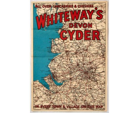
Lot 126
Original vintage advertising poster issued by the Whiteways Devon Cyder all over Lancashire and Cheshire, in every town and village on this map. Poster features a map of Lancashire and Cheshire. The Whiteway family have made cider in Devonshire for generations and exported thousands of gallons of cider to America during the post-prohibition era. At the peak of production the apple orchards at Whimple were the most extensive in the world. The company ceased production in 1985 due to decline in sales. Good condition, folded as issued, light staining. Country of issue: UK, designer: Unknown, size (cm): 40.5x27.5, year of printing: 1930s
Lot 198
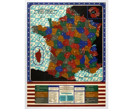
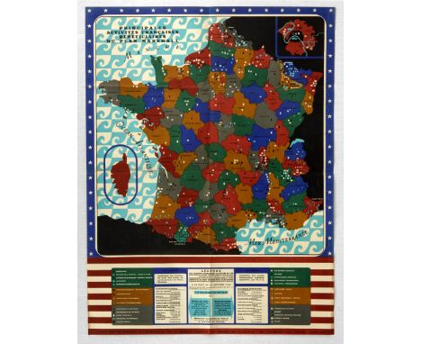
Original vintage propaganda poster for 'Main French activities benefiting from the Marshall Plan.', published by the Information Services of the Special Mission in France. The Marshall Plan (officially the European Recovery Program, ERP) was an American initiative passed in 1948 for foreign aid to Western Europe. The United States transferred over $12 billion (equivalent to over $128 billion as of 2020) in economic recovery programs to Western European economies after the end of World War II. Replacing an earlier proposal for a Morgenthau Plan, it operated for four years beginning on April 3, 1948. The goals of the United States were to rebuild war-torn regions, remove trade barriers, modernize industry, improve European prosperity, and prevent the spread of Communism. The graphic features a colour coded map of the various regions of France, indicating industrial and utilitarian improvements throughout the country. It is decored with a border of the American flag's stars and stripes. Very good condition, fold lines, small tears, scuffing. Country of issue: France, designer: Unknown, size (cm): 76.5x57.5, year of printing: 1950
Lot 199
Original vintage propaganda poster for 'Main French activities benefiting from the Marshall Plan.', published by the Information Services of the Special Mission in France. The Marshall Plan (officially the European Recovery Program, ERP) was an American initiative passed in 1948 for foreign aid to Western Europe. The United States transferred over $12 billion (equivalent to over $128 billion as of 2020) in economic recovery programs to Western European economies after the end of World War II. Replacing an earlier proposal for a Morgenthau Plan, it operated for four years beginning on April 3, 1948. The goals of the United States were to rebuild war-torn regions, remove trade barriers, modernize industry, improve European prosperity, and prevent the spread of Communism. The graphic features a colour coded map of the various regions of France, indicating industrial and utilitarian improvements throughout the country. It is decored with a border of the American flag's stars and stripes. Very good condition, fold lines, scuffs. Country of issue: France, designer: Unknown, size (cm): 76.5x57.5, year of printing: 1950
Lot 241
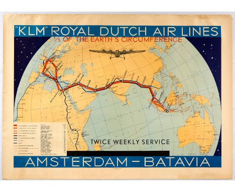
Original vintage poster - KLM Royal Dutch Airlines Amsterdam Batavia 1/3 of the earth's circumference Twice weekly service - featuring the air route on a map of the world marked in red with other routes for corresponding connections and combined services, Imperial Airways and Air France routes, and railway and steamship routes through Europe, Africa, Asia and Australia and across the Indian Ocean with an image of a propeller plane flying towards the viewer above and the legend on the lower left with services and distances marked, the main title text in bold white lettering against the top and bottom blue borders with white stars against the dark background behind the globe. Batavia became a Dutch colony in 1619 and the capital of the Dutch East Indies from 1800; located on the island of Java the city was renamed Jakarta after gaining independence in 1949 and is the capital of Indonesia (Djakarta from 1942-1972; Jakarta from 1972). KLM (Koninklijke Luchtvaart Maatschappij / Royal Dutch Airlines; since 1919) is the flag carrier of the Netherlands. Horizontal. Good condition, creasing, tears, staining, foxing, small paper losses. Country of issue: Holland, designer: Unknown, size (cm): 100x72, year of printing: 1934

Lot 27
Original vintage travel poster A Map of Yorkshire issued by British Railways - Great illustrated map by Estra Clark (1904-1993) features a map of the English county Yorkshire with towns and cities coat of arms, illustrated historical figures, landmarks, plants, wildlife, districts and rail travel routes. Published by the Railway Executive (Eastern and North Eastern Regions). Printed by Waterlow and Sons LTD London and Dunstable. Horizontal. Good condition, folds, tears on margin, water stain on right margin. Country of issue: UK, designer: Estra Clark, size (cm): 127x102, year of printing: 1949
Lot 272
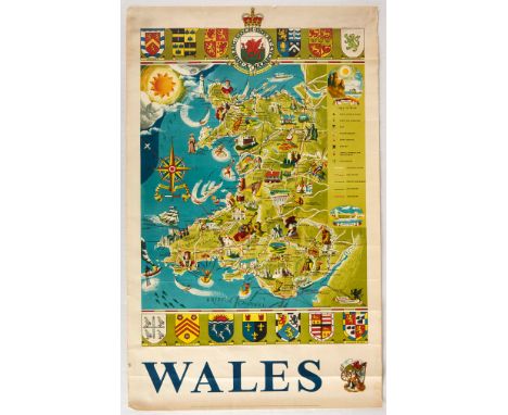
Original vintage travel poster featuring a pictoral map of Wales including great illustrations by Frederick Griffin such as places of interest, historical figures, tourist attractions, sporting activities, towns, cities, villages, ports, harbours, spas, seaside resorts, youth hostels, castles, religious sites, rail routes, roads, county boundaries sea and air routes. Coats of arms of local Welsh areas surround the illustrated maps. Published by the British Travel and Holidays Association. Good condition, creasing, tears, staining, browning. Country of issue: UK, designer: Frederick Griffin, size (cm): 101x63, year of printing: 1950s
-
109198 item(s)/page