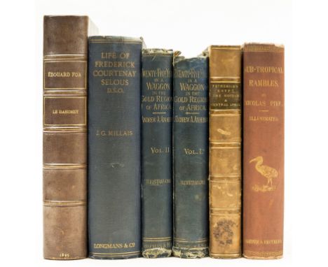

Africa.- Anderson (Andrew A.) Twenty-Five Years in a Waggon in the Gold Regions of Africa, 2 vol., first edition, 14 plates, 2 loose, occasional marginal pencil annotations, cracked hinges, ink inscription to front pastedown, original cloth, rubbed and worn, small loss to spine head (vol. 1), spotting to upper cover (vol. 1), [Hosken p.4], 1887 § Petherick (John) Egypt, the Soudan and Central Africa, first edition, large folding map backed on linen, small tear neatly repaired, ex-library with ink stamp to title, contemporary half-calf, a little rubbed, [Czech p.129], 1861 § Pike (Nicolas) Sub-Tropical Rambles in the Land of the Aphanapteryx, first edition, frontispiece, plates and illustrations, 4 folding maps, cracked upper hinge, original cloth, a little rubbed, small loss to spine extremities, New York, 1873 § Foà (Édouard) Le Dahomey, portrait frontispiece, plates, folding map at end, contemporary half-morocco, a little rubbed, Paris, 1895; and another, 8vo (6)
We found 109182 price guide item(s) matching your search
There are 109182 lots that match your search criteria. Subscribe now to get instant access to the full price guide service.
Click here to subscribe- List
- Grid
-
109182 item(s)/page
Oxford.- Pocket Companion for Oxford (A), 5 engraved plates, contemporary ink signature to blank, bookplate, contemporary calf, a little rubbed, cracked upper joint, Oxford, for R. Clements; and sold by R. Baldwin, 1756 § The New Oxford Guide: or, a Companion through the University, folding engraved map and 4 plates, occasional spotting, bookplate, contemporary half-calf, rubbed, Oxford, for J. Fletcher; W. Jackson; E. Newbery; and J. Bew, [1786] § A New Pocket Companion for Oxford: or, Guide through the University, folding engraved map & 8 plates, tiny marginal worm damage, bookplate, faded contemporary signature, cracked upper hinge, contemporary half-calf, rubbed, Oxford, 1803 § A Companion to the Guide, and a Guide to the Companion: being a Complete Supplement to all the Accounts of Oxford hitherto published, engraved illustrations, previous owners ink inscriptions to front free endpaper, bookplate, contemporary half-calf, rebacked, rubbed, Oxford, 1806, 12mo (4)
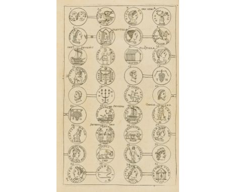
Greece.- Wheler (George) A Journey into Greece, first edition., 7 engraved plates (4 of coins, 3 smaller), numerous illustrations in text, lacking folding map, some spotting, occasional foxing, lightly browned, 19thc entury polished calf, gilt, joints split, but holding, corners worn, rubbed, [Atabey 1328; Blackmer 1786; Wing W1607], Printed for William Cademan, 1682; and 2 others, Greece, folio & 8vo (3)

London.- Brunel.- Teape & Son (Tower Hill-based publishers) The Thames Tunnel, advertisement for the opening of the Thames Tunnel to the public, with three sections of the tunnel, including a representation of the iron shield, a longitudinal section of the tunnel beneath the Thames and the two arched entrances from the shaft, with a map of the surrounding area below, wood-engraving and latterpress, on wove paper, sheet 290 x 290 mm. (11 1/2 x 11 1/2 in), folds and some minor loss, minor spotting and browning, extensive ink inscription verso, and small note recto, unfamed, [1843] § Beamish (Richard) Memoir of the Life of Sir Marc Isambard Brunel, second edition, with 3 pp. autograph letter from the author bound in, original green cloth, rubbed, 4to, 1862 (2)

Oxford.- Ingram (James) Memorials of Oxford, 3 vol., engraved frontispieces and 97 plates, illustrations, folding map, tissue-guards, 2 additional plates loosely inserted, occasional very faint spotting, previous owner's ink signatures to front free endpaper, bookplate, contemporary morocco, gilt spines, a little rubbed, 8vo, 1837.


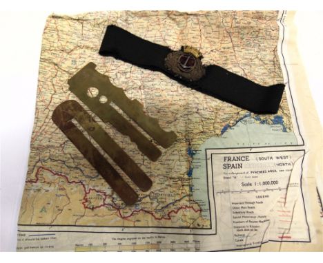
MILITARIA - A SECOND WORLD WAR R.A.F. SILK ESCAPE MAP 43A - France (North West), Belgium (West and Central), Holland (Part of) & The Pyrenees / 43B - France (South West), Spain (North), German-Swiss Frontier; together with a Merchant Navy bullion thread and metal and cap badge; and two brass button cleaning sticks, (4).

A large collection of antique maps and illustrative works, to include a print after Manesson Mallet (1630-1706), 18th century maps depicting Asia, Africa and a quantity of material regarding the geographical history of Israel and Palestine, with a number of plates depicting Jerusalem, a foldout map 'Betts's Map of Scripture Geography', an illustrated booklet (possibly 16th century), excerpts from 'Arias Montanus Benedictus', 1571, and others (qty loose in portfolio)

After Henry Burn, The Priory Park, Chichester 1852, coloured print, 12cm by 18cm, (a/f), a hand coloured print of Chichester, The Cathedral from the East, General View and Market Cross, 15.5cm by 21cm, a 19th century coloured print of Chichester Cathedral, 23cm by 16.5cm, and a map of Sussex after J Cary, 22.5cm by 27.5cm

EPHEMERA. Large box of Ephemera to include 19th century cheque books, late 19th early 20th century scrap books, coronation ephemera, telephone map reading file, Police regulations for the king and queen 1934 visit to Salford stating what time they would arrive and which constables would be on duty and where he would be placed, plus much more interesting paper work, please see accompanying image.


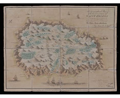
Read (Lieutenant R.P.) Saint Helena, pictorial map of Napoleon`s place of exile., title and dedication upper right 'This Geographical Plan of the Islands & Forts of Saint Helena is dedicated by permission to Field Marshal his R Highness the Duke of Kent and Strathearn', Napoleon`s facsimile signatures lower right with ships and spouting whales, the island with depictions of the topography, trees, roads and numerous buildings, formed from 16 panels mounted on a linen backing, 59.5cm x 45cm

John Speed , A new and accurat Map of the World. Drawne according to ye truest Descriptions, latest Discoveries & best Observations yt have beene made by English or Strangers, 1651, California as an island, celestial hemispheres, figural allegorical representations of Water, Earth, Air and Fire and diagrams of solar and lunar eclipses, hand coloured, 53cm x 41cm


Political interest papier mache snuff box, circa 1795, The lid decorated with four figures and a map of Polonia (Poland) probably depicting Catherine the Great, on the left a seated woman , next to her a man with star decoration to his chest and both wearing ermine and blue sashes, on the right two men , one possible their son, Paul of Russia, pointing at the map and conversing with a man wearing dark blue jacket and decoration to his chest. An angel flies above them, to the base a crown and staff, the Fourth annexation of Poland took place in the 1790s and this appears to commemorate this act


Guthrie (William). A New Geographical, Historical, and Commercial Grammar; and Present State of the several Kingdoms of the World..., 4th edition 1774, improved and enlarged; The Astronomical part by James Ferguson, folding double hemisphere world map frontispiece and interior folding maps, leather bound


Christopher Greenwood (1786-1855) and John Greenwood (fl. 1821-1840) Map of the County of Essex, from an actual Survey made in the year 1824, by C & J Greenwood, 13, Regent St. Pall Mall, London, corrected to the and published Jany 1st Present period 1831, with an image of Audley End House to the bottom right, 72cm x 63cm, framed and glazed


Tony Warr Collection, Postcards, a broad mixed subject selection of 82 cards inc. set of 6 comic cards for A B Velox Tyres signed A.P.F.R early write-away series. Also postally used on Xmas Day (5), fantasy, map cards of London, Mottos and poems, black humour, German military comic, early chromo, Boer War advert for Kitchener's Postcards, bicycles, Theatre Adverts, Year Dates etc (mainly gd)
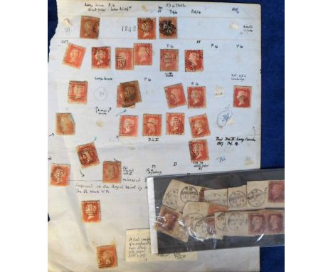
Stamps, Coins and Postal History, mixed selection inc. 3 margin GB 2d blue with black Maltese cross postmark, a quantity of 1d reds on album page and stockcard, early postal stationery items inc. scarce FPO postmark from Russia 1920, also some aviation related covers inc. one postmarked and overprinted with Pan-America First European Round Flight stamp with map, also some postal stationery, stamp cards, early Victorian 1d red on cover etc. Sold with a small quantity of GB and foreign coins inc. some modern crowns.


Peggy Coates, 'Uplands', Study of a bedroom interior with bed, standard chair, rug and chest of drawers etc. looking towards a Georgian sash window, signed, 'Coates, oil on board, 55 x 37cm, together with an unsigned still life study of hydrangeas, oil on board, 36 x 46cm and a reproduction map of Hampshire showing part of Southampton up to the Berkshire borders


TWO JOHN CARY COUNTY MAPS, Northumberland 1831 and Lancashire 1833, two J & C Walker maps, North Wales 1855 and Durham 1850, a map of Lincolnshire published with W. White's History and Directory 1841, all in original cases, together with a large fragment of Greenwood & Co. Northumberland 1844, comprising most of the Western sheet (7) (Est. plus 21% premium inc. VAT)


ROBERT MORDEN (1650-1703), The East riding or Yorkshire, hand coloured engraved map with title cartouche and scale, plate size 14" x 16 1/2", together with two maps by Richard Blome (1660-1705), The North Riding of Yorkshire 1672 and the West Riding of Yorkshire, both approx. 10" x 12" , Hogarth frames (3) (Est. plus 21% premium inc. VAT)


-
109182 item(s)/page