We found 109182 price guide item(s) matching your search
There are 109182 lots that match your search criteria. Subscribe now to get instant access to the full price guide service.
Click here to subscribe- List
- Grid
-
109182 item(s)/page


Lot 1452
Speede (John) - The Countie Westmoreland & Kendale, The Cheif Towne described, 1611-1631, George Humble, hand-coloured engraved map, 38 x 51cm; one other of The Countie Palatine of Lancaster, described and divided into Hundreds, 1610, hand-coloured engraved map, 38 x 51cm; and one other of The Countie Palatine of Chester, with the most ancient Citie described, showing coats of arms and inset town plan for Chester, hand-coloured engraved map, 38 x 51cm (3). Lancaster – minor tear to fold.Westmoreland – minor tear to fold.Chester – several major creases, approx. 4” tear at 4 o’clock.None appear to be stuck down.


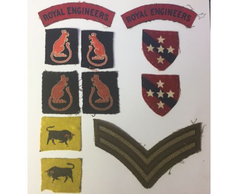
Lot 6289
WW2 British cloth formation signs and paperwork group: Pair 11th Armoured Division (Printed on felt, some moth) pair: Pair 7th Armoured Division, machine woven: pair 7th Armoured Division, machine embroidered: pair printed Royal Engineers shoulder titles: Pair of printed Southern Command Royal Engineers formation signs: single printed Clp's stripe: book "Taurus Pursuant: a history of the 11th Armoured Division, printed 1945: booklet the Eighth Army: 2nd Army Thanksgiving Service booklet: 13th Field Sqn RE Campaign in Europe map x 2: Colour Poster Formation Signs 1945: Illustrated Guide to the Tank Museum, 19th edition 1977: Paperback book "Monty" by Nigel Hamilton.


Lot 6362
WW2 British & US Paperwork, US Alberto Varga Pin up's from Esquire magazine some mounted, a folder of WW1/WW2 Australian fund raising badges, ARP Map of Twickenham, US Air Navigation maps, photographs, reprinted British weapons training posters on German weapons, Jon's "Two Types" Cartoon booklet, etc. (Q)


Lot 331
REVOLT IN THE DESERT BY T.E. LAWRENCE No.180 of a limited large paper edition of 300, Jonathan Cape, London 1927 with fold out map, The Tower of London by William Harrison Anisworth, London, 1840, The Works of Rabelais in two volumes, No.1660, London, 1927, Past and Present, Latter-Day Pamphlets both by T. Carlyle and A History of English-Speaking Peoples, The Birth of Britan by Winston S. Churchill (7) Condition Report: Available upon request


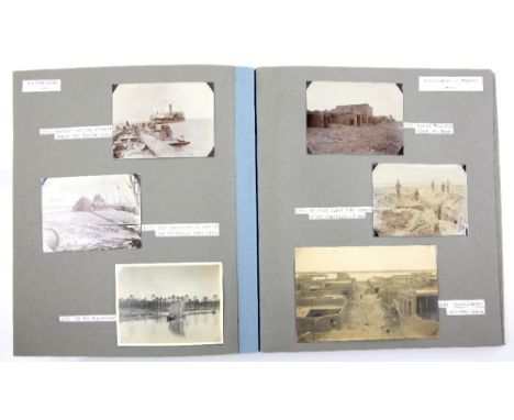
Lot 2203
Sir George Cunningham Buchanan (20 April 1865 - 14 April 1940) The Tragedy of Mesopotamia, with Map, 1938, album of photographic images with index, The Tragedy of Mesopotamia, Photographs, Basra, The Tigris, The Euphrates, Kut-el-Amara to Baghdad, the Karun River Persia, (many dated 1916) (45 in all), album of cuttings from his time in South Africa in 1923, together with other related documents.At the start of the First World War in 1914, Buchanan was working in India, until called to support the British Mesopotamian Expeditionary Force at Basra in Mesopotamia (now part of modern-day Iraq) with advice on improving shipping channels into the port. After many delays, he was finally able to design and supervise construction of a line of wharves complete with cranes, sheds, roads and railway lines. Approx number of photographs, Basra x12, Tigris x9, Euphrates x6, Baghdad x6, Karun river x10
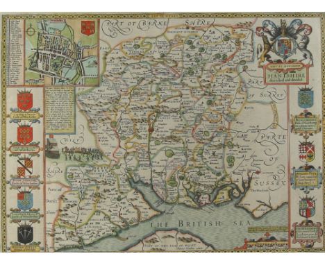
Lot 2204
First edition 16th century John Speede map of Hantshire, published I Sudbury and G Humbell, 39cm x 51cm.. Overall condition good. Good margins throughout. No major faults found. Colours slightly faded in parts. Area of wear visible on map side where the print verso is showing through, approximately 5cm x 5cm square.


Lot 2206
16th century map of Hampshire with Royal Coat of Arms, 39cm x 43cm . has been cut very close to the margin, has not been out of the frame, dos not look like it has been been stuck down, overall condition good no major faults found some slight stains/foxing due to age colures strong appear to be original


![Africa.- Fries (Lorenz) [Tabula I Aphricae], trapezoidal Ptolemaic map covering Morocco, Mauritania, the Western Sahara, Alge](https://cdn.globalauctionplatform.com/6f8681f1-25c8-4dbd-ac46-aa0800a57f0f/c79e22db-4157-47ac-8ab1-aa0800b69448/468x382.jpg)
Lot 1
Africa.- Fries (Lorenz) [Tabula I Aphricae], trapezoidal Ptolemaic map covering Morocco, Mauritania, the Western Sahara, Algeria and the western edge of Libya, with the Pillars of Hercules depicted on either side of the Straits of Gibraltar, and the Atlas Mountains covering large parts of the land, woodcut on laid paper with small indistinct watermark, sheet 400 x 510 mm. (15 3/4 x 20 in), Latin text verso with woodcut borders and decoration, central vertical fold, several small repairs to wormhole damage in the margins, minor surface dirt, handling creases and rough edges, unframed, [Strasbourg, circa 1535].

Lot 10
America.- Bowen (Emanuel) A New & Accurate Map of Louisiana, with Part of Florida and Canada, and the Adjacent Countries; A New & Accurate Map of the Islands of Newfoundland, Cape Breton, St. John and Anticosta, two maps from 'A Complete System of Geography', both with ornate rococo-style title cartouches, engravings on laid paper without watermarks, each platemark approx. 360 x 425 mm. (14 1/4 x 16 3/4 in), sheets approx. 410 x 450 mm. (16 1/8 x 17 3/4 in), central vertical folds, minor surface dirt and handling creases, unframed, [1747[ (2).
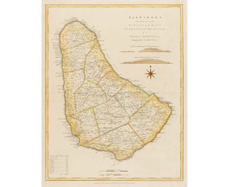
Lot 100
West Indies.- Barbados.- Jefferys (Thomas) Barbadoes, Surveyed by William Mayo, Engraved and Improved by Thomas Jefferys, large-scale map showing the eleven parishes of Barbados with their areas listed in a key below, with islands' ports, settlements, forts, churches, roads, and sugar plantations with landowners' names also listed, engraved map with hand-colouring on laid paper with watermark of a Strasbourg lily, platemark 650 x 490 mm. (25 1/2 x 19 1/4 in ), sheet 705 x 525 mm. (27 3/4 x 20 3/4 in), central horizontal fold, some spotting and browning, unframed, Robert Sayer, 1775.

Lot 102
World.- Stent (Peter) A New and Accurat Map of the World Drawne according to the best and Late Discoveries: Anno Domi. 1663, double-hemisphere world map elaborately embellished with top and bottom borders with allegorical vignettes of the four elements and seasons, one featuring an elephant, two smaller celestial spheres, Copernicus's heliocentric astronmical model of the solar system in the upper left, and portraits of Drake, Cavendish, Magellan, and Noort, engraving on laid paper with indistinct watermark, sheet 385 x 505 mm. (15 1/8 x 19 7/8 in), laid onto paper support, handling creases and folds, repair to section of loss at central right hand quadrant, several small areas of loss, particularly just above the southern hemisphere celestial sphere, rough edges, with publishers imprint in the lower margin that reads: 'London-Printed and are to be sould by Peter Stent at ye white horse in guilt spurr Street without Newgate: 1665', [circa 1660s].⁂ Scarce.

Lot 108
British Isles.- Camden (William) Britannia, decorative frontispiece only from the atlas of the same name, with decorative border featuring vignettes and figures surrounding a map of the British Isles, engraving on laid paper without watermark, platemark 265 x 165 mm. (10 1/2 x 6 1/2 in), sheet 325 x 215 mm. (12 3/4 x 8 1/2 in), repaired tear in the lower margin, but outside the platemark, surface dirt and light browning, unframed, [circa 1610].

Lot 11
America.- Guthrie (William) A Map of the United States of America Agreeable to the Peace of 1783, following the Treaty of Paris, showing the states of New York and Pennsylvania bordering Lake Ontario, with part of East Florida in the south, Louisiana to the West and Canada to the north, engraving with outline hand-colouring on laid paper with watermark of Strasbourg lily, sheet 365 x 400 mm. (14 3/8 x 15 3/4 in), vertical and horizontal folds as issued, central vertical fold with small area of splitting in the upper section, minor handling creases, unframed, [1786].

Lot 110
British Isles.- Jansson (Jan) Insularum Britannicarum Acurata Delineatio ex Geographicis Conatibus Abrahami Ortelii, map of the British Isles after Ortelius with north oriented to the right, featuring sea monsters, sailing ships, compass roses and rhumb lines, engraving with some hand-colouring, platemark 395 x 510 mm. (15 1/2 x 20 1/8 in), under glass, some repaired tears and areas of restored loss in the lower margin, surface dirt and some browning, framed, [1646].

Lot 111
NO RESERVE British Isles.- Chatelain (Henri Abraham) Cart Pour L'Introduction a L'Histoire D'Angleterre ..., decorative and elaborate map of the British Isles, with portraits of the British Kings and Emperors from 801 (Egbert) to 1702 (Anne) bordering the sheet, the map showing the routes of the Saxons in the 5th Century, engraving with hand-colouring, platemark 525 x 610 mm. (20 3/4 x 24 in), under glass, some minor surface dirt and light browning, framed, [circa 1720].
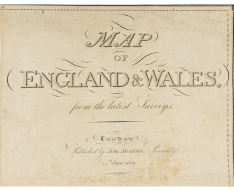
Lot 113
British Isles.- Stockdale (John) Map of England & Wales from the Latest Surveys, highly detailed 20 sheet map by Samuel Neele, engravings, loose and mounted on linen support, each sheet approx. 605 x 680 mm. (23 3/4 x 26 3/4 in), some minor worm hole damage, some occasional spotting and surface dirt, loose between early marbled boards with red morocco gilt label to upper cover, boards detached, lacking spine, worn, elephant folio, 1809.⁂ Scarce. An impressive large-scale map, which when joined measures well over 3 metres in height, and almost 2 and a half metres wide.

Lot 115
British Isles.- Lewis (Samuel, publisher) A Map of England and Wales, Divided into Counties, Parliamentary Divisions, & Dioceses, presented in four sections, covering the North East, South East, North West, and South West of England, with large decorative title upper right in the North East section, and large engraved view of The General Post Office London upper left in the North West, the view by Griffiths after Allom, engraved folding maps, drawn by R. Creighton, and engraved by J. Dower, each dissected and mounted on linen, all with hand-colouring, each approx. 1060 x 880mm., occasional surface dirt, browning and spotting, folding into original purple straight-grain morocco, gilt decorated borders, 8vo, rubbed, lacking spines, S. Lewis & Co., 1841 (4).
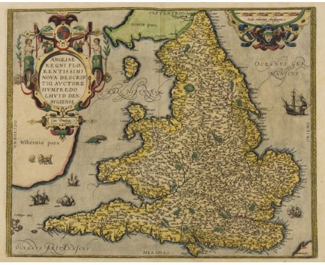
Lot 116
England and Wales.- Ortelius (Abraham) Angliae Regni Florentissimi Nova Descriptio, Auctore Humfredo Lhuyd Denbygiense, map of England and Wales compiled from Mercator's 1564 wall map of the British Isles and Lhuyd's manuscript map of 1568, with large decorative title cartouche in the upper left, many sailings ships and sea creatures in the surrounding waters, engraving with early hand-colouring, on laid paper with watermark of an indistinct armorial device, platemark 382 x 468 mm. (15 1/8 x 18 3/5 in), sheet 445 x 555 mm. (17 1/2 x 21 7/8 in), Latin text verso, central vertical fold, unframed [1601].Literature:VdB 19

Lot 118
England and Wales.- Chatelain (Henri Abraham) Nouvelle Carte du Gouvernement Civil d'Angleterre et de Celuy de la Ville de Londres, folio sheet containing a map of England and Wales, a plan of London, and two engravings with allegorical figures representing the empire, with panels of French text providing a detailed history of the civil governmental structure, engraving with some hand-colouring, sheet 445 x 490 mm. (17 1/2 x 19 1/4 in), central vertical fold with some splitting, several small tears in the margin, but not affecting the map, unframed, [circa 1708]; together with a French map of the British Isles by Delamarche, 1829, unframed, (2).

Lot 119
England and Wales.- Luffman (John) A New Pocket Atlas and Geography of England and Wales, Illustrated with fifty-five Copper plates shewing all the Great Post Roads with the Towns & Villages situated thereon..., engraved title, preface and fifty-four circular county maps with descriptive text below and a double page engraved map of England & Wales (complete), occasional toning to sheets, the map of England and Wales with splitting to folds, in early half morocco marbled boards, publisher's printed label to upper cover, rubbed and worn, 8vo, Lackington, Allen and Co., 1806.

Lot 12
America.- Rochefoucauld-Liancourt (François Alexandre Frédéric, duc de la) Map of the United States, Canada &c, intended to illustrate the Travels of the Duke de la Rochefoucault Liancourt, detailed map of the United States east of the Mississippi, with the short-lived state of Franklin, here described as 'Franklinia' just east of Tennessee, engraving on laid paper without watermark, sheet 440 x 350 mm. (17 1/4 x 13 3/4 in), central and vertical folds, some spotting and browning, handling creases, unframed, published by R. Phillips, 1799.⁂ Scarce.

Lot 120
Ireland.- Speed (John) The Kingdome of Irland Devided into Severall Provinces, and the againe Devided into Counties. Newly Described, decorative map with strapwork title cartouche flanked by putti, the Royal coat of arms, sea monsters, sailing ships, and a compass rose, with vignettes of people of the region at the lower left, including 'The Gentleman and Gentlewoman of Ireland', 'The Civill Irish man and woman', and 'The Wilde Irish man and woman', engraving on laid paper with indistinct watermark, sheet 410 x 530 mm. (16 1/8 x 20 7/8 in), central vertical fold, some areas of small loss, particularly in the upper left corner, handling creases, small nicks and tears, surface dirt, would benefit from restoration, unframed, Sudbury and Humble [1612].

Lot 122
Scotland.- Albrizzi (Giovanni Battista) Scozia, detailed map with title cartouche supported to two mermaids in the left corner, and with vignette of the Scottish coast in the upper right corner, engraving on laid paper with indistinct watermark, sheet 430 x 340 mm. (17 x 13 3/8 in), central and vertical folds, some minor spotting within the map, the edges of the sheet with acidic browning, unframed, [circa 1740].

Lot 123
Wales.- Ortelius (Abraham) Cambriae Typus Auctore Humfredo Lhuydo Denbigiense Cambrobritano, map of Wales, with details of mountain ranges, forests, and towns, strap-work title cartouche, sea monster, and ship off the coast, engraving with hand-colouring, on laid paper with postal horn watermark, platemark 375 x 495 mm. (14 3/4 x 19 1/2 in), sheet 425 x 510 mm. (16 3/4 x 20 in), Latin text verso, minor nicks to extremities, printers' crease to the centre right, some minor off-setting and surface dirt, unframed, [Antwerp, circa 1590s].Literature:VdB 21

Lot 128
London.- Fairburn (John) London and Westminster, detailed folding map of London by Mogg, extending from Knightsbridge to the The Isle of Dogs, and North to South from Pentonville to Kennington, with key and inset 'Plan of the Proposed Wet Docks', and decorative title with vignette depicting Father Thames in the upper right corner, engraving with some hand-colouring, 442 x 642 mm. (17 1/2 x 25 1/4 in), dissected and mounted on linen, minor surface dirt, folding into marbled slip-case with printer's label to upper cover, rubbed and worn, 8vo, 1796.Literature:Howgego 203 (2)

Lot 13
America, Mexico and Caribbean.- Bowen (Emanuel) A New & Accurate Map of Mexico or New Spain together with California New Mexico &c., with inset map of the Galapagos Islands, engraved map on laid paper, platemark 365 x 425 mm. (14 3/8 x 16 3/4 in), sheet 410 x 455 mm. (16 1/8 x 17 7/8 in), central vertical fold with repaired split in the lower section, some surface dirt and minor browning, unframed, [1747]; together with A New and Accurate Map of Terra Firma and the Caribbe Islands, showing most of the Caribbean from the southern part of Cuba through the Lesser Antilles and the northern part of South America to the Amazon Basin, engraving on laid paper without watermark, platemark 360 x 425 mm. (14 1/4 x 16 3/4 in), sheet 410 x 455 mm. (16 1/8 x 17 7/8 in), central vertical fold with fine splitting to lower central section, minor spotting and surface dirt, unframed, 1747 (2)

Lot 131
London.- Faden (William) A New Topographical Map of the Country in the Vicinity of London, Describing all the New Improvements, Second edition, showing from East Acton to Barking, and Beckenham to Upper Edmonton, with title in the upper margin, engraved map with hand-colouring on two sheets joined, platemark 835 x 810 mm. (32 7/8 x 31 7/8 in), sheet 920 x 840 mm. (36 1/4 x 33 in), minor off-setting, otherwise no condition issues of note, unframed, 1815 Literature:Howgego 250 (2)

Lot 132
London.- Wallis (J. & E.) The City of London, in the Time of the Saxons (about the Year 1000) Compiled from the Most Authentic Documents, historically speculative map showing London as it was imagined in Saxon times, engraving with hand-colouring, sheet 420 x 540 mm. (16 1/2 x 21 1/4 in), trimmed to borderline but includes publisher's letters, laid onto canvas support, some areas of loss, particularly centre left, some tears and splits with old folds visible, canvas on wooden stretchers, unframed, 1817.
-
109182 item(s)/page