We found 109198 price guide item(s) matching your search
There are 109198 lots that match your search criteria. Subscribe now to get instant access to the full price guide service.
Click here to subscribe- List
- Grid
-
109198 item(s)/page


Lot 780
Fine large folding map by C. and J. Greenwood - Map of London From An Actual Survey Made in the years 1824, 1825 and 1826, published by Greenwood, Pringle & Co. 13 Regent Street, Pall Mall, August 21 1827, engraved by James & Josiah Neele, linen-backed edged in silk, folding into brown leather slip case with gilt tooled title. (Removed from Heath House, Little Braxted) CONDITION REPORT Outer cover in the form of a book is in fair order. Wear commensurate with age and use. Damaged on corners and wear to gilt on fore edges area. Map itself is complete, edge binding is largely missing, there are a few small holes and patches of discolouration commensurate with age and use. Map is mounted on canvas

Lot 783
One volume - An Historical Account of Dunwich, Blithburgh, Southwold, by Thomas Gardner, London 1754, in later half calf binding CONDITION REPORT A pencil note on the inside page states 'Pages 177 - 184 numbered as 161 - 168. 5 full page plates and 1 folding plate, prospect of Southwold. No map. Occasional green biro page numberings etc'. Areas of foxing throughout, some heavy patches


![[GUTHRIE, WILLIAM] : [ATLAS TO GUTHRIE's SYSTEM OF GEOGRAPHY]. London C. Dilly & G. Robinson, 1785. Lacks letterpress title.](https://cdn.globalauctionplatform.com/d9433e90-632e-44bb-9c2e-a4bc00a577cd/109bd886-9bb4-41b3-891b-00b78459a22d/468x382.jpg)
Lot 32
[GUTHRIE, WILLIAM] : [ATLAS TO GUTHRIE's SYSTEM OF GEOGRAPHY]. London C. Dilly & G. Robinson, 1785. Lacks letterpress title. Folio. 25 engraved maps hand-coloured in outline, mostly double-page, a few folding, plus plate of armillary sphere. The map of Germany very worn, the chart of the world showing the tracks and discoveries of Captain James Cook very worn & torn, some damp marking. Old boards worn & crudely repaired


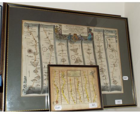
Lot 263
A John Ogilby map, The Road from London to Chichester, another similar, The Continuation of the Road from London to the Lands-End, and another, The Road from Bristol to Weymouth in Dorset-Shire (3) Condition report Report by RB Not modern reproductions. The road from Bristol to Weymouth in Dorsetshire: some browning and staining (small) The continuation of the road from London to Lands-End: generally good. The road from London to Chichester: generally good, with some very light browning.

Lot 204
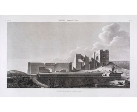
Egypt.- Commission de Sciences et Arts d’Égypte. - A good group of plates from Description de l’Égypte, both classical and modern Egypt at the time of the Napoleonic invasion, including ancient temples, mosques and street scenes, architectural elevations and perspective views, also a few natural history plates and a large map, a few from the second edition, 68 plates comprising 57 single folio plates, of which 5 are coloured, and 11 double or folding plates, of which the large map is coloured, v.s., the largest 430 x 1260mm., some spotting and surface dirt, some sheet edges frayed, 1800-1829 (68)

Lot 217
Kent.- Speed (John) - Kent with her Cities and Earles Described and observed, with inset plans of Canterbury and Rochester, lower left and right, respectively, title cartouche and coats-of-arms above, engraved map with hand-colouring, 380 x 510mm., English text verso with woodcut initial by William Godbid, central vertical fold, Bassett and Chiswell, [1676].

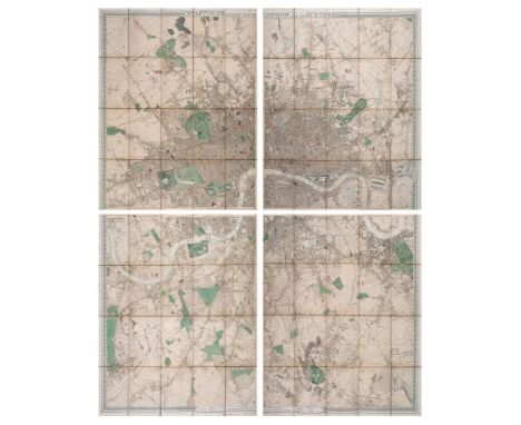
Lot 221
Stanford (Edward) - Stanford's Library Map of London and its Suburbs, large folding engraved map in 4 parts, each dissected and linnen-backed, hand-coloured in outline, light finger soiling and dusting, blue and gold paper covers with index map labels, each sheet measuring c.955 x 840cm, n.d. [pre-1868]. The 1868 edition appears to include additional docks and railwal lines, making this an earlier edition of Stanford's map.
Lot 45
Plinius Secundus (Caius) - Historiae naturalis libri xxxvii, 2 vol., engraved double-page map, 11 engraved plates of coins and head-piece to dedication, woodcut initials and ornaments, offsetting, contemporary blind-stamped vellum, vol.1 upper joint split at head, both vol. lightly soiled, Paris, A.-U.Coustelier , 1723; and 9 others, 16th and 17th century Continental, most defective, v.s. (10)
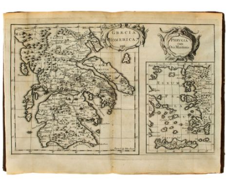
Lot 53
translator ) The Iliad, 6 vol. in 5, engraved portrait frontispiece translator ) The Iliad , 6 vol. in 5, engraved portrait frontispiece, folding map of Greece, plate of the siege of Troy, plate of the shield of Achilles, a further double-page plate, list of subscribers, 6 privilege ff., errata f., lacking half-title, vol. IV lacking 3A2 (supplied in later ink), water-stained, contemporary panelled calf, sympathetically rebacked, mostly modern morocco labels, corners worn, folio, W.Bowyer, for Bernard Lintott, 1715-1720; and 9 others, 4to editions, odd vol. or defective, 4to sold not subject to return (14)
Lot 55
Foulis.- Pope (Alexander, - The Iliad, 4 vol., half-titles, engraved folding map, occasional spotting, contemporary calf, spines gilt and with red morocco label (2 chipped), rubbed, [Gaskell 467], Glasgow, Robert and Andrew Foulis, 1767 ; and 18 others, Pope's Homer, including an 11 vol.12mo set, 1720-1726, the others odd vol., v.s. (22)
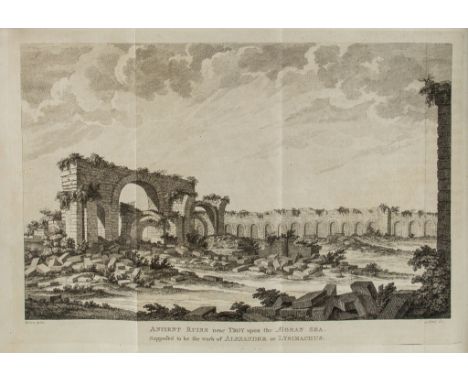
Lot 56
An Essay on the Original Genius and Writings of Homer An Essay on the Original Genius and Writings of Homer: With a Comparative View of the Ancient and Present State of the Troade , first trade edition (previously privately printed in only 7 copies), half-title, engraved portrait frontispiece, title vignette, folding map of Troy, two single-plate views of ruined bridges, folding view of ruins near Troja Nova, tailpiece vignette, offsetting, a few small marginal stains, occasional spotting, contemporary tree calf, rebacked, preserving original backstrip, corners chipped, [Blackmer 1836], by H.Hughs for T.Payne, 1775; and 3 others, by the same (a copy of the 1776 edition and 2 copies of the 1824 edition), 4to & 8vo (4) 'Wood's Essay is one of the most interesting of the 18th century works on Homer. He was one of the first to advance the theory that writing was unknown to Homer and to establish the concept of oral tradition' (Blackmer).
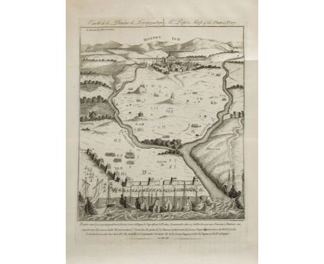
Lot 57
Description of the Plain of Troy. . . Translated from the Original not yet... Description of the Plain of Troy. . . Translated from the Original not yet published. . . with notes and illustrations, by Andrew Dalzel , first edition, first issue (with the map facing p.115), large folding engraved map of Ancient Troy dated 1 March 1792, 3 further folding maps, without half-title, offsetting to large map, occasional spotting, contemporary speckled polished calf, gilt, rebacked in modern calf, gilt, [Atabey 696; Blackmer 993], 4to, Edinburgh, for T.Cadell, 1791. 'Le Chevalier's survey of the Troad marks the beginning of modern archaeological exploration in that area' (Blackmer).
Lot 60
A Vindication of Homer and of the Ancient Poets and Historians A Vindication of Homer and of the Ancient Poets and Historians, who have recorded the siege and fall of Troy. In answer to two late publications of Mr. Bryant , first edition , aquatint folding map of the Troad and 5 views printed in sepia, plates trimmed at foot, affecting the printed captions to varying degrees, lightly browned, [Abbey, Travel, 398; Atabey 840; Blackmer 1157], York, W.Blanchard for T.Cadell , 1798 bound with Bryant (Jacob) Some Observations upon the vindication of Homer, and of the Ancient Poets and Historians, who have recorded the Siege and Fall of Troy, errata slip pasted on final f., Eton, by M.Pote and E.Williams, 1799 and Morritt (John Bacon Sawrey) Additional Remarks on the Topography of Troy, as Given by Homer, Strabo and the Ancient Geographers; In Answer to Mr. Bryant's Last Publications, half-title, lacking map, for T.Cadell, Jun. and W.Davies, 1800 and Francklin ( Captain William) Remarks and Observations on the Plain of Troy, Made During an Excursion in June 1799 by William Francklin, Captain in the Service of the East India Company, and Author of A Tour to Persia, engraved folding map, hand-coloured in outline, light offsetting to title, for R.Faulder, 1800, together 4 works in 1 vol., occasional spotting, some light browning, 19th century marbled boards, vellum , cornes, rebacked in modern calf, 4to A good selection of works on Troy and its place in Homer.
Lot 66
Ilios: The City and Country of the Trojans, first edition in English ( Dr. Henry) Ilios: The City and Country of the Trojans, first edition in English , frontispiece, folding map and 6 plans, plates, illustrations, original pictorial cloth, gilt, spine ends and corners rubbed and little frayed, 1880 § Maclaren (Charles) The Plain of Troy Described, first edition, presentation copy from the author , half-title, folding map and 3 folding plans, illustrations, occasional spotting, original pictorial cloth, gilt, rubbed, 1863; and small quantity of others, Archaeology and Topography, most 20th century, v.s. (Sm.Qty.)

Lot 74
English. [The Bible and Holy Scriptures conteined in the Olde and Newe... English. [The Bible and Holy Scriptures conteined in the Olde and Newe Testament], [translated by William Whittingham, Anthony Gilby, Thomas Sampson & others], 2 parts in 1, Geneva version, double column, roman letter, folding engraved plate (with loss of right hand part), 1 folding map (tears along fold), woodcut illustrations, lacks general title, and all to E1, NT and map laid down, large tears affecting O1, R5, 2C3, 2H4-2H6, 2M3, 01-2Q1, 2T1, 2T6, 2X6, 2Y3 & 4, 3B2-5, 3M2, 305, 5B6, 5L6, 5P1 & 2, numerous other small tears, a few margins with repairs, browned, margins trimmed, 17th century ink annotations of Thomas Lovedy of Shalford, Surrey, some other notes in shorthand, later endpapers, 19 century half calf, gilt, rubbed, upper cover working loose, upper cover detached, spine worn and lower joint broken, [Herbert 144; STC 2118], sm. folio, Christopher Barkar [sic], 1576; sold not subject to return.
Lot 84
Plot (Robert) - The Natural History of Oxford-shire..., first edition , imprimatur leaf, engraved title-vignette, large folding engraved map with border of coats-of-arms, 16 engraved plates, with errata leaf and final blank, a little browned, map foxed and soiled with short tear, contemporary calf, rubbed, rebacked, [Wing P2585; Nissen 3192], folio, Oxford, at the Theater, [1677].


Lot 642
A linen backed map of England by the Scarborough Co U.S.A. featuring all railways and steamship lines with distances between stations and landings. Geographical Counties and Boroughs. A 1908 Deed of Sale, shares in the Birmingham Coffee House Ltd, together with all 1815 Map of Estates of the Dove House Manor (with detail) hand drawn (3) good historical information.


-
109198 item(s)/page