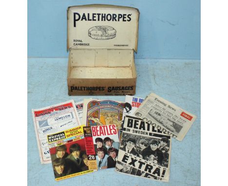
We found 109198 price guide item(s) matching your search

Refine your search

Year

Filter by Price Range
  • List
  • Grid
  • 109198 item(s)
    /page

Lot 19

Middle East.- Niebuhr (Carsten) Description de l'Arabie, 2 vol. in 1, third edition in French, half-titles, 25 engraved maps and plates, 6 folding including a large map of the Yemen, folding letterpress table, privilege leaf at end, occasional marginal soiling, otherwise an excellent clean copy, bookplate of William Tighe, contemporary mottled sheep, rubbed, some worming to lower cover, rebacked and edges repaired, [cf.Atabey 873], 4to, Paris, Brunet, 1779.

Lot 2

Americas.- [Davie (John)] Letters from Buenos Ayres and Chili, 6 hand-coloured aquatint plates, some light soiling, tear to one leaf repaired, contemporary half calf, spine gilt, 1819 § Gisborne (Lionel) The Isthmus of Darien in 1852. Journal of the Expedition of Inquiry for the Junction of the Atlantic and Pacific Oceans, half-title, 4 folding maps hand-coloured in outline, original cloth, spine very slightly faded, 1853 § Howard (Maj.-Gen. O.O.) My Life and Experiences among Our Hostile Indians, plates, some colour, original cloth, rubbed, rebacked in morocco, faded, Hartford, Conn., for subscribers only, 1907, first editions, both slightly rubbed; and an Stanford's map of South America, 8vo (4)⁂ The last concerns the Native American tribes of North America.

Lot 20

South America.- Bolingbroke (Henry) A Voyage to the Demerary..., second edition, folding engraved map, light spotting, modern morocco-backed cloth, spine faded, 1809 § Purdy (John, editor) Laurie's Sailing Directory for the Ethiopic or Southern Atlantic Ocean..., fourth edition, illustrations, a few stains, original cloth-backed boards, paper labels on upper cover and spine (latterdefective), rubbed and stained, 1855; and another, South America, 8vo (3)

Lot 23

Britain.- Coburn (Alvin Langdon) The Book of Harlech, 20 mounted plates, light spotting, original boards, spine and joints worn, Harlech, D.H.Parry, 1920 § Lewis (William, publisher) Lewis's New Traveller's Guide, and Panorama of England and Wales, 42 engraved maps (lacking map and text for Rutland), some staining, original cloth, paper label on upper cover, 1835 § Barber (Thomas) Picturesque Illustrations of the Isle of Wight, engraved vignette title, plates and double-page map, original blind-stamped cloth, [1834], rubbed; and 14 others, mostly British topography, 4to & 8vo (17)

Lot 24

NO RESERVE British Isles.- Camden (William) Camden's Britannia, Newly Translated into English with Large Additions and Improvements... by Edmund Gibson, engraved portrait frontispiece by R. White, 7 engraved plates of coins only (of 8, lacking plate VII) and 12 double-page and/or folding maps by Robert Morden only (of 50, lacking most of the county maps), the 3 general maps (Britannia Romana, Britannia Saxonica and England) and map of Rutland all with outline hand-colouring), engraved and woodcut illustrations, one or two full-page, title with pencil signature of M.A.Cook, plate IV of coins with contemporary manuscript "A Correct Table of ?Areas of Circles for Ale and Beer" in ink on verso, occasional light soiling or browning but generally very clean, plate IV of coins with small tear repaired, one or two other small tears or marginal defects, contemporary calf ruled in blind, rebacked, corners repaired, rubbed, [Wing C359], folio, by F. Collins for A.Swale...and A & J Churchill, 1695; sold not subject to return⁂ First edition of Gibson's translation and the first with Morden's maps

Lot 28

Somerset.- Speed (John) Somerset-Shire described, inset bird's-eye view of Bath, upper left, coats of arms lower left, royal arms and ships off the north coast, engraved map, 385 x 515 mm. (15 1/4 x 20 1/4 in), English text verso with woodcut initial by William Hall and John Beale, some small areas of restoration to central fold, some surface dirt and light browning, Sudbury and Humble, [circa 1611-12].

Lot 3

Americas.- Royal Geographical Society. A Selection of Papers on Arctic Geography and Ethnology, 2 folding maps, original cloth, spine very slightly faded, 1875 § Willis (Nathaniel P.) Canadian Scenery Illustrated, 2 vol. in 1, engraved map, additional vignette titles and 116 plates after W.H.Bartlett, some foxing, ex-library copy with stamps but plates unstamped, contemporary half red morocco, spine gilt, g.e., library label to upper cover, n.d. § Chappell (Lt. Edward) Voyage of His Majesty's Ship Rosamond to Newfoundland and...Labrador, first edition, lacking map and plates, title soiled, spotting, original boards, uncut, worn, 1818 § Picture of Philadelphia...being a Complete Guide for Strangers, engraved frontispiece, folding engraved map hand-coloured in outline, some foxing, contemporary half oan, spine faded, Philadelphia, E.L.Carey & A.Hart, 1835, rubbed; and 2 others, v.s. (6)

Lot 5

Asia.- M'Leod (John) Voyage of His Majesty's Ship Alceste, to China, Corea, and the Island of Lewchew, third edition, engraved portrait frontispiece, folding engraved map with vignette, 5 hand-coloured aquatint plates, frontispiece lightly offset on title, small marginal tear at fold of map, later ink inscription to front free endpaper, contemporary half calf, spine gilt with red roan label, rubbed, small worn patch to upper joint, 8vo, 1819.

Lot 6

Australasia.- Caire (Nicolas, photographer) Aborigines of Australia; Scenes on the River Murray; Melbourne Scenery, 3 albumen prints, each c.155 x 200mm., tipped to brown paper mounts with printed captions in gold or silver, all a little faded, South Yarra, Victoria, [?1880s]; with c.40 other photographs from an album featuring Australia (manuscript captions including "A Blackfellow's Camp", "A Ford on the Watts River" & "An Australian Country House"), Boston, Quebec, Niagara Falls and other subjects, most mounted on loose thick paper leaves, some captioned in manuscript, most rather faded, [?1880s] § Stevens Cox (James, editor) Australian Aborigines drawn from Life by Captain Tetley c.1805, one of only 30 specially-bound copies, plates, original morocco-backed boards, St. Peter Port, Toucan Press, 1977 § Domestic Scenes in New Zealand, folding map, illustrations, spotted, ex-library copy with labels and stamps, original cloth, label to upper cover, spine faded and chipped at head, 1857, v.s. (sm.qty)

Lot 60

NO RESERVE Railways.- Bradshaw (George) [Bradshaw's Railway Companion] Bradshaw's Railway Time Tables, and Assistant to Railway Travelling..., No.3, folding map of railways of England and Wales with routes supplied by hand in pink & yellow (detached), 4 double-page maps, one with routes in pink & yellow, 4 double-page plans of Birmingham, Liverpool, Manchester and Leeds, some light browning or soiling, original cloth with gilt-stamped viridian label on upper cover, a little rubbed and faded, one or two small stains, 10th Mo. 25th [25th October] 1839; and issue for 1842, 16mo⁂ Third issue of the eponymous railway timetables, the first of which appeared on the 19th October 1839, restricted to Northern railways, with a second for southern railways on 25th October. This third issue is a combination of the the two and is therefore the first covering all England.

Lot 66

[Misson de Valbourg (Henri)] Memoires et Observations faites par un Voyageur en Angleterre, first edition, additional engraved pictorial title, title in red and black, folding engraved map and 19 plates, most folding, lightly browned, contemporary ink signature of F.Jackson on front free endpaper, modern bookplate of K.T.Butler, The Hague, Henri van Bulderen, 1698 § [Bertels (J.) & others.] Respublica Lutzenburgensis, Hannoniae, et Namurcensis, engraved title (soiled and with small ink stains), Amsterdam, W.Blaeu, 1635, both a little browned, contemporary vellum, rubbed; and another, 8vo & 12mo (3)

Lot 8

Australasia.- Australia.- Labillardiere (Jacques Julien Houton de) Voyage in Search of La Pérouse, 2 vol., first English edition, large folding engraved map and 45 plates, advertisement leaf at end, with additional 6pp. publisher's catalogue advertising Chauchard's 'Map of Germany...' and long list of subscribers bound in at end, frontispiece foxed and offset onto title, one plate 'View of Admiralty Islands' water-stained at upper margin, other plates lightly offset but generally a good clean copy uncut in the original boards, rubbed, spine with orange paper label but stained and a little worn and defective, [Ferguson 309; Sabin 38421], 4to, for John Stockdale, 1800. ⁂ Account of the search for the Comte de La Pérouse and his ships which had disappeared in the Solomon Islands in 1788 during their expedition to explore the Pacific and Australasia. The voyage included extensive visits to the coast of Western Australia and Tasmania and contains information on the natives and their customs, implements and languages as well as important early contributions to Australian botany.

Lot 82

Boswell (James) An Account of Corsica, the Journal of a Tour to that Island..., first edition, half-title, engraved title-vignette, folding engraved map by Thomas Phinn in second state (with imprint), lacking final blank, D2 in first state with "John Home" affixed to first quotation, E2 in first state, Z3 in second state with "Mariani" corrected, some light soiling or browning, offsetting to map, modern half mottled calf, [Gaskell 473; Rothschild 442-445], 8vo, Glasgow, Robert & Andrew Foulis, 1768.

Lot 9

Canada.- Willis (Nathaniel P.) Canadian Scenery Illustrated, 2 vol. in 6 parts, first edition, engraved portrait, additional vignette titles, map and 117 plates after W.H.Bartlett, tissue guards, original roan-backed glazed pictorial viridian boards, spines gilt, rubbed, 4to, 1842.

Lot 245

RAF silk escape map of Northern Europe, dated June 1953.

Lot 246

RAF silk escape map of Northern Europe, dated June 1953. Approx. 62cm².

Lot 569

Falklands Campaign, Minefield map of Goose Green. A Veteran bring back.

Lot 570

WWII pattern Luftwaffe map of Turkey dated 1943.

Lot 574

WWII Nazi marked aluminium map tube. No lid.

Lot 586

WWII pattern RAF folder with flight map and radio paperwork.

Lot 173

EPHEMERA, selection, inc. posters (2) Victory Times Square 1945, 1953 National Savings map of the British Isles showing festivals and customs (30 x 40 and smaller); comics (17), inc. Fantastic Four, Iron Man, The Invaders, Black Panther, Claw, The Amazing Spiderman; Superman record by Power Records; railway selection, inc. modern postcards, photos, commemorative covers, Prescott-Pickup, beermats etc; booklets, inc. Blackpool, 2016 Scalextric catalogue, 1974 Piccolo Racing and Sports Cars etc; Hamlyn Walt Disney Classic Movie Poster Book; photos, Washington Photographs Beautiful Northwest, Benllech Bay, Mevagissey etc; Wills Wild Flowers incomplete (in sleeves) etc., G to EX, Qty

Lot 686

VINTAGE MAP CASE,GAS MASK CASE AND VINTAGE SAW IN CASE

Lot 3294

A George III silkwork map, A Map of England and Wales, embroidered by A. Baggley, Walton School, 1798, worked in coloured silk threads and delineated with counties, Scotland and Ireland, surrounding bodies of water, France to lower margin, Britannia and composition title to upper-right, signed and dated within the framework garland of bellhusks, laurels and foliage, the margin with indistinct ink manuscript inscription, oval, 52cm x 42cm, ebonised and gilt frame

Lot 3712

William Hole (d. 1624), after Christopher Saxton (c. 1540 - c. 1610), Universi: Derbienfis Comitatus [...] (sic), two-page map of Derbyshire, from William Camden's Britannia, presumably London 1637, copperplate engraving, later touches of hand-colouring, 31.5cm x 36cm

Lot 3730

A mid-20th century 'folio' map of Derby and its environs, 1 : 1250 or 50. 688 inches to 1 Mile, each page 53cm x 50cm, Printed and published by the Ordnance Survey Office, 1947, hinged wooden boards, 57.5cm x 54cm overall

Lot 3801

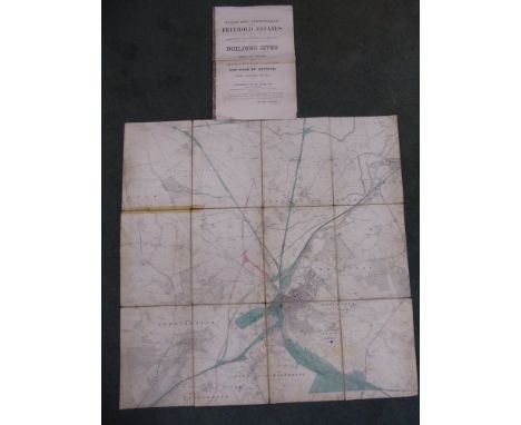
Messrs. Knight, Frank & Rutley:~ The Quenby Estate, Leicestershire [...], Including Quenby Hall, A perfect specimen of Jacobean Architecture, circa 1610 - 1620, By direction of The Lady Henry Grosvenor, To be Offered by Auction, in Three Lots [...] Friday, June 27th [1913], 2 o'clock, (Unless previously disposed of by Private Treaty), 43pp, illustrated throughout with reproduced photographic reproductions of the exterior of the house, its elevation and grounds, and also its interior complete with house contents, printed card covers as issued, floppy crown folio; loosely inserted related ephemera, including, after Robert Morden (c. 1650 - 1703), a two-page map, Leicestershire, from Camden's Britannia 1722, monochrome copperplate engraving, 39cm x 44cm, the front pastedown pasted with a map of Leicestershire/Rutland highlighting the circumference of the estate, carbon copies and letters relating to the Ashby of Quenby pedigree and their South Carolina branch, an early 19th century engraving of the front elevation from the Gentleman's Magazine, August 1814; b/w postcards of the house and its elevations (4); newspaper and magazine clippings, etc

Lot 3802

Milne (A.A.), Winnie-The-Pooh, Decorations by Ernest H. Shepard, first edition, Methuen & Co. Ltd., London 1926, xi, [5], 158pp, [2], gilt-embossed green cloth as issued, pictorial map endpapers, 12mo

Lot 3833

Virtue's Picturesque Beauties of Great Britain: Kent [...] in a Series of View, By the Most Approved Artists, Taken expressly for this Work, By Messr. G. Shepherd, H. Gatineau [...], Comprising the Principal Cities & Towns, Public Edifices & Dock Yards; Seats of the Nobility and Gentry; Hospitals, Churches, Castellated & Monastic Ruins, &c., Accompanied by Historical & Biographical Notices, Published by G. Virtue, London [1829], 130pp, [ii], pull-out six-fold copperplate engraved map of the county bound between half and full-title page, contemporary gilt-embossed calf, marbled endpapers, square 4to

Lot 5

An 18th century map of Nottingham, by Pieter Meijer 1767; an 18th century print, A Remarkable Ancient Ruin in Nottingham Park

Lot 48

Corum, Bubble GMT, ref. 383.250.20, a stainless steel wristwatch, no. 800651, circa 2001, automatic movement, cal. ETA 2893-2, black dial with map of the world, luminous square markers and Arabic numerals to the quarters, luminous baton hands, centre seconds hand, centre dual time zone hand, date aperture at 6 o'clock, bezel with Arabic numeral 24 hour track, screw down crown, screwed down glazed back with six screws, case, dial and movement signed , on a Corum black leather strap with double deployant clasp, width 45mm

Lot 331

A 19th century colour print, Henley Regatta, a map of Sussex and a number of other colour prints

Lot 344

A 19th century hand-coloured map of Buckinghamshire, in strip frame

Lot 345

An 18th century hand-coloured map, Britannicae Insulae, dated 1760, in washed strip frame

Lot 346

A French late 18th/early 19th century hand-coloured map, Le Royaume D'Angleterre, in oak strip frame

Lot 347

An 18th century hand-coloured map "An Historical Map of the Roman Empire and the Neighbouring Nations" by William Del Isle, dated 1709, unframed

Lot 348

Two hand-coloured maps of Italy, in strip frames, and a 19th century map of Berkshire, in Hogarth frame

Lot 351

Moll: a 17th century hand-coloured map of Berkshire, in strip frame

Lot 286

A quantity of The Beatles and Rolling Stones ephemera, together with an Evening News last edition, Illustrated London News and an Ordnance Survey map of Edinburgh

Lot 402

Two prints relating Southsea including a map of Albert Road in the style of a London underground map.

Lot 309

C & J Greenwood Map of the County of Lincoln, from an actual survey made in the years 1827 & 1828, engraved by Josiah Neale, 352 Strand, twelve fold cloth with marbled cover, published by Greenwood & Co, Regent Street, Pall Mall, London, Jany 26th 1831, 65.5cm x 79cm.

Lot 354

A John Ogleby map The Road from London to Boston in Lincoln, probably 1675 edition, hand touched in colours, No 36, 35cm x 42cm, a small quantity of other maps, one hand dated 1695 in pencil but possibly later, facsimile map of Lincolnshire, etc, (qty).

Lot 400

After John Speede (1552-1929) Map of the County of Warwickshire, with vignettes of the towns of Warwicke and Coventree, together with the Armes of such honorable famylies as have bene Earls of Warwick, hand coloured engraving, maple framed, 40cm x 53m.

Lot 410

Victorian plates and book illustrations, contained in two portfolios, and a 19thC map.

Lot 345

An old Ordnance Survey Folding Map of Doncaster in a scale of 6" to 1 statute mile, and a set of auction plans and particulars for various properties in Leeds, April 1863.

Lot 351

A large 19th century folding linen backed Map of France by Herisson, new edition, published 1815, 50" (127cms) x 77" (195cms) in leather case.

Lot 145

A folder of signed magazines and other autographs of famous racing drivers. Jason Plato, Fabrizio Giovanardi, Andy Rouse, Stuart Turner, Tim Harvey, Map signed by Bobby Unser & Colin Chapman, Book - A Century of Winning signed by Stuart Turner, Carrera Cu

Lot 284

SEGUR, General Count Philip De - History of the Expedition to Russia, Undertaken by the Emperor Napoleon in the Year 1812 : 2 vols, 3 plates, fold. map, half calf, 8vo, 1826 & 1825.

Lot 332

FIELD, Colonel Cyril - Britain's Sea Soldiers,: 3 vols, org. morocco backed cloth, 4to, together with the scare map volume 1924 (4)

Lot 354

ROSS BLADENSBURG, Lieut. Colonel Sir John - The Coldstream Guards, 1914-18,: 2 vols plus map. vol. org.cloth in d/w, 8vo, 1928., with 2 others relating to the Coldstream Guards.

Lot 385

COLERIDGE, William Hart - Charges Delivered to the Clergy of the Diocese of Barbados and the Leeward Islands : calf spine detached, frontispiece map, 3 folding hand tinted maps, 2 folding plates, 2 letters enclosed, 8vo, 1825.

Lot 401

FRANKLIN, John - Journey to the Shores of the Polar Sea, in 1819-20-21-22 : 4 vols, fold. map, 23 plates, half calf, small 8vo, John Murray, 1829. With - Parry, Sir W.E, Three Voyages for the Discovery of a North-West Passage : 4 vols. fold. map, 12 plates, half calf, small 8vo, John Murray, 1835. With 3 others similar.(11)

Lot 403

GILPIN, William - Three Essays : on Picturesque Beauty; on Picturesque Travel; and on Sketching Landscape : 7 tinted aquatint plates, half morocco, tall 8vo, 1794. Remarks on Forest Scenery : 2 vols, map, 31 aquatint plates, half morocco, tall 8vo, 1791. Observations, on Several Parts of England, Particularly the Mountains and Lakes of Cumberland and Westmoreland : 3 maps, 27 plates, half morocco, tall 8vo, 1808. Observations on Several Parts of the Counties of Cambridge, Norfolk, Suffolk, and Essex : 20 plates, half morocco, tall 8vo, 1809.* uniformly bound( 6)

Lot 406

HEDIN, Sven - The Silk Road : org. cloth, fold map, illust, 8vo, 1938. With a box of mainly travel books inc. Fiji.(box)

Lot 409

IZACKE, Samuel - Remarkable Antiquities of the City of Exeter : eng. frontis, fold, map, fold. plate, cuts in text, calf neatly rebacked, 8vo, third ed. 1734.

Lot 415

MARTYN, Thomas & LETTICE, John - The Antiquities of Herculaneum : Vol. One (all published), map, 50 engraved plates, calf rebacked, 4to, 1773. With 4 others on antiquities.(5)

Lot 421

PLOT, Robert - The Natural History of Stafford-Shire : (map), title-page, 26 double plates, 11 full page plates, cont. calf rebacked, folio, 1686.* the map is separated from the book, mounted on linen and folded

Lot 422

PULMAN, George P. R - The Book of the Axe : folding map mounted on linen, illustrated inc. 12 tinted lithograph plates, org. cloth rebacked, stout 8vo, 1854.

Lot 423

PULMAN, George P. R - The Book of the Axe : folding map, illustrated inc. 12 tinted lithograph plates, org. cloth rebacked, stout 8vo, 1854.

Lot 424

SANDYS, George - Sandys Travailes : Containing a History of the Original and Present State of the Turkish Empire : frontis, fold map, fold panorama plate, 3 plates, 44 plates in text, half calf front board detached, folio, 1652.

Loading...Loading...
  • 109198 item(s)
    /page

Recently Viewed Lots