We found 109182 price guide item(s) matching your search
There are 109182 lots that match your search criteria. Subscribe now to get instant access to the full price guide service.
Click here to subscribe- List
- Grid
-
109182 item(s)/page


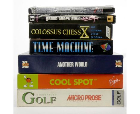
Lot 12
A collection of PC and Atari ST floppy disks and cds, to include Cool Spot (boxed, disk and manual), Another World (boxed, disk, game wheel and manual), Time Machine (boxed, disks and manual), Colossus Chess X (boxed, disks and manual), Microprose Golf (boxed, disks and manual), Grand Theft Auto (boxed, sleeve, map/poster, CDs and manual e.g. Tourist Guide), and Dungeon Lords (broken case, CD and manual)
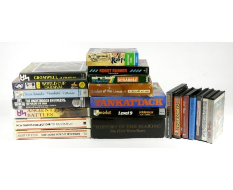
Lot 37
A collection of twenty one Sinclair Spectrum cassettes, seven boxed games to include The Reaper (manual), U.S Gold History In The Making (manual), Shadow Of The Unicorn (manual & interface), Tank Attack (manual, game board and pieces), Lancelot (map, prize form and manual), Computer Scrabble (manual) and Robot Runner (manual), fourteen cased cassettes to include Daley Thompson?s Decathlon (no manual), Gunfright (insert), Casino Royal (no manual), Trivial Pursuit Baby Boomer Edition (no manual), Trivial Pursuit Young Players Edition (no manual), Geoff Capes Strong Man (manual), Rocky (no manual), Cromwell At War1642-1645 (manual), Encyclopaedia Of War Ancient Battles (historical notes and manual), Best Of PCW Software For The Spectrum (manual), Brian Clough?s Football Fortunes (game pieces, money and cards), The Unorthodox Engineers : The Pen And The Dark (manual), PCW Games Collection (manual) and World Cup Carnival (wall chart, stickers, patch and manual) To be sold on behalf of Monkey World, Dorset


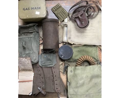
Lot 4135A
2695302 GDSMN. W. FRASER. S. GDS. General Service Medal with Palestine Clasp, 1939-1945 War Medal, Defence Medal, 1939-1945 Star, Africa Star, Oak Leaf Leaf Emblems with letter of issue Mention-in-Despatches in the Military Supplement to the London Gazette of 24/6/43 Middle East to Sgt W. Fraser. Camerons. Silk "Escape Map" of the Middle East, together with photographs and other items relating to his service in the Middle East, stop WD Mark I No. 300 stopwatch 1917, with silver chain and Masonic ball cross.


Lot 91
A group 20th century items including, a Doulton Lambeth Victorian jubilee jug, a Royal Doulton Winston Churchill Toby jug, other commemoratives, after Robert Morden, two maps of Yorkshire, and a third map of the East Riding of Yorkshire by Ellis; together with two 1980s spitting image rubber toys; and five boxes of 19th century and later Royal and other commemorative ceramics (qty)


Lot 675
Mappe mit Graphiken des 16. bis 20. Jhs. U. a. Karte von Deutschland XVI Blatt, Konvolut Ansichten, Stadtpläne von Rastatt, Mannheim, Karlsruhe, Heidelberg, Hildesheim, Utriusques Frisorium Regionis gefaltete Karte, Oldenburg Karte, Carte d'une Partie Hesse-Cassel sowie Map of Germania Antiqua. Kupferstiche, teilw. coloriert und sign., u. a. Merian, dazu diverse Drucke, 20 x 16 cm bis 56 x 46 cm.

Lot 2143
A map of Norway and a map of Greece both on silk.Lot 2143: Both are in good condition for the age with multiple folds. Norway- No visible dates or marks, reference box ID in English. Size 55cm x 41cm.Greece- 1:3,000,000Reverse side 1:1,750,000, reference in English. International boundaries, Austria March 1938, Hungary Sept 1938, Romania June 1940with the USSR august 21, 1940. Bulgaria Aug 30 1940, size 60 x 50 approximately. No visible makers marks or dates to either.
![[Situationists] Guy Debord, Le Jeu de la Guerre (Board game), 1977 Paris, Les Jeux stratégiques et historiques, 1977. White c](https://cdn.globalauctionplatform.com/22e31b51-3022-4a65-8d1e-aea0009b964b/5ea1a604-9448-4841-b194-aea000d12628/468x382.jpg)
Lot 6058
[Situationists] Guy Debord, Le Jeu de la Guerre (Board game), 1977 Paris, Les Jeux stratégiques et historiques, 1977. White cardboard box with black printed title, 37 x 29 x 3.5 cm. First commercial edition (in unknown, yet small number) produced by Debord and the French movie producer Gérard Lebovici, after a metal version was made in an edition of 3 or 4 copies.The box contains a game board consisting of a sheet of thin white felt printed with a map of black and white squares, letters and numbers, folding out to 49.5 x 55.5 cm; 34 round-shaped wooden game pieces printed with letters and a booklet with game rules, 21.5 x 26 cm, 23 pp. Aim of the game is to completely destroy the enemy and his arsenal, based on strategic war theories of Clausewitz. The box has moderate age toning, two corners are torn, else in good condition. Very rare. In 1987, Alice Becker-Ho and Guy Debord released the book Le Jeu de la Guerre that illustrates Debord's game, published by Editions Gerard Lebovici. Several versions including computer games have appeared since.
![[Situationists] Rumney and Psychogeography (1) Alan Woods, The Map is Not the Territory: Ralph Rumney. Manchester University](https://cdn.globalauctionplatform.com/22e31b51-3022-4a65-8d1e-aea0009b964b/6871428b-b307-45d2-ab5b-aea000d1a3ff/468x382.jpg)
Lot 6075
[Situationists] Rumney and Psychogeography (1) Alan Woods, The Map is Not the Territory: Ralph Rumney. Manchester University Press, 2000. Hardcover, black cloth gilt with title printed in gold, 24 x 19.5 cm, 204 pp. Very good copy. Biography of the British artist and wanderer Ralph Rumney (1934-2002), remarkably designed in collaboration with Alan Ward. As one of the co-founders of the London Psychogeographical Association, Rumney was involved in the founding of the Situationist International, though he was 'amically' expelled after seven months.(2) Ralph Rumney, Constats: 1950-1988. Exhibition catalogue England & Co, London 1989, 12 pp. (3) Ralph Rumney, Pourvu que ca dure. Pamphlet by the Bureau des Inspections Banalatiques, 1999, 18 pp, second edition of 200 copies. (4) Merlin Coverley, Psychogeography. Harpenden, Pocket Essentials, 2006. Hardcover, 158 pp. This book examines the origins of psychogeography in the Situationist Movement of the 1950s. Very good copy. (total 4)
![[Subculture] [Punkrock. Skateboarding] Maximumrocknroll (1) No. 1-2, 4, 6-8, 10-11, 30. Berkeley, late 1982- Nov. 1985. Apart](https://cdn.globalauctionplatform.com/22e31b51-3022-4a65-8d1e-aea0009b964b/7db4e18a-a5af-402e-b8ee-aea000dafafb/468x382.jpg)
Lot 6482
[Subculture] [Punkrock. Skateboarding] Maximumrocknroll (1) No. 1-2, 4, 6-8, 10-11, 30. Berkeley, late 1982- Nov. 1985. Apart from one, they each have the original paper covers.*9 issues of epoch-defining hardcore punkrock zine. Includes the rare first issue September 1983 skate special which put e.g. JFA, The Big Boys or Drunk Injuns on the map. Steve Caballero's comment in The Faction: 'Skating tends to be hard and fast and punk is hard and fast. That really boils down to what the connection is.' -and (2) 7 English and American punk/wave zines, late 70s, early 80s.Added: (3) Raymond Pettibon (design). 'Black Flag December 1980 Schedule'. Offset lithograph, 21.5 x 28 cm. Rare handbill for their first national tour. (total 17)


Lot 134
HARRY. A. FRANCK. 'Wandering in China', illustrated with photographs, pub London 1924, 1st edit, red cloth: F.S. SMYTHE. 'Kamet Conquered'; A. KRARUP-NIELSEN. 'The Dragon Awakes', with 84 illustrations and a map; G.N. ROERICH. 'Trails To Inmost Asia', 1931; WALTER EDGAR GEIL. 'The Great Wall of China', 1909. (5)

Lot 1294
1819 "Cary's New Pocket Plan of London, Westminster and Southwark, with all the adjacent Buildings in St.George's Fields, &c. &c. to which are annexed (from Authority) the exact Boundary of the Rules of the Kings Bench Prison, the situation of the receiving Houses of the General & Penny Post Offices references to the Public Buildings &c &c also a Correct List of upwards of 350 Hackney Coach Fares", folding linen backed map in slip case, W61.5cm H42cm


Lot 940
BOOKS - POLWHELE, Reverend Richard, 'The History of Cornwall' full leather gold tooled hardcover, Civil, Military, Religious, Architectural, Commercial, Biographical and Miscellaneous. Printed by T. Flindell, Trewman & Son, Michell & Co. 1803-16. Seven volumes, including folding map by J. Cary, list of prints and pedigrees, errata slip, forty one plates including a large folding plate of Mounts Bay, thirteen pedigrees including three folding tables. Two books but having all seven volumes. Full calf with contrasting Moroccan labels, marbled interior papers, height 28.5cm, width 22.5cm, depth 5cm. Comes with copy of Roger Collicott Books invoice.


Lot 194
A German aviator map of the Luftwaffe from July 1943. At the top, between 2 eagles on swastika, the title "Navigationskarte in Merkatorprojektion". The map comprises Italy with Sicily, the Greek peninsula, Asia Minor, Cyprus and the North of Africa. size: 124x104 cm on glossy paper unmounted. The map was probably executed when the Germans were preparing for the invasion of the allies in Sicily. They were tricked by the British in believing they were invading Greece - "Mincemeat Operation". The invasion took place in Sicily on the 10th July 1943.Γερμανικός χάρτης αεροπορίας του Β' Παγκοσμίου πολέμου.

Lot 4
Alfred Wallis (British, 1855-1942)Mount's Bay with St Michael's Mount signed 'A WALLIS' (lower right)oil on panel23.5 x 33 cm. (9 1/4 x 13 in.)Footnotes:ProvenanceBen Nicholson and Dame Barbara Hepworth, by whom gifted toMiss Misomé PeileWith Crane Kalman Gallery, London, May 1986, where acquired by the family of the present ownerPrivate Collection, U.K.ExhibitedLondon, Tate Gallery, Alfred Wallis, organised by the Arts Council of Great Britain, 30 May-30 June 1968, cat.no.34; this exhibition travelled to York, City Art Gallery, 6-28 July, Aberdeen, Aberdeen Art Gallery, 3-25 August, Kendal, Abbot Hall Art Gallery, 31 August-22 SeptemberMount's Bay with St Michael's Mount enjoys distinguished provenance having formerly been in the collection of Ben Nicholson and Barbara Hepworth. The duo were married in 1938 and moved to St Ives the following year just before the outbreak of war, at the invitation of Adrian Stokes and his wife Margaret Mellis. Nicholson however, together with Christopher Wood, had 'discovered' Wallis a decade prior and he was to become the elder artists greatest champion, both buying and promoting his work among some of the most progressive artists, intellectuals and collectors in 1930s Britain. Of that first encounter, Nicholson said 'In August 1928, I went over for the day to St Ives with Kit Wood: this was an exciting day, for not only was it the first time I saw St Ives, but on the way back from Porthmeor beach we passed an open door in Back Road West and through it saw some paintings of ships and houses on odd pieces of paper and cardboard nailed up all over the wall, with particularly large nails through the smallest ones. We knocked on the door and inside found Wallis, and the paintings we got from him then were the first he made.' (Exh.cat., Two Painters, Works by Alfred Wallis and James Dixon, Merrell Holberton London, 1999, p.105).Wallis's unique approach to perspective and the immediacy of his painting sparked a period of intense experimentation for Ben, clear in his exploration of material and proportion during this pivotal period. An inscription verso shows that the work passed from the Nicholson/Hepworth collection to that of Misome Peile. Peile was born in Hampshire into a naval family and studied art under Leonard Fuller at the St Ives School of Painting from 1939-43, where presumably she encountered the 'St Ives set'. She was an invited member of Newlyn Society of Artists and, in 1949, a founder-member of Penwith Society of Arts.The present lot depicts Mount's Bay, so named for the presence of St Michael's Mount, and is a stretch of coastline that features repeatedly in the artist's work. Wallis, as a seaman, would have held great appreciation for the bay, understanding the shelter it offered vessels in bad weather, then as it still does today. The location is identifiable by the Mount itself, upper centre, and the Lizard lighthouse, top right. A large ship with full sails dominates the composition whilst a gaff-rigged cutter bobs alongside in the choppy waters and the crew of both vessels can be seen working on board. Alfred Wallis went to sea at an early age and worked as an Ordinary Seaman on merchant sailing ships for at least sixteen years. Crew lists show that at 19 or 20 years of age he sailed from Penzance to Newfoundland on a Westcountry schooner, Pride of the West, and returned on a Devon ship 'Belleaventure' a brigantine similar to the sailing ship that is the main subject of this painting. Wallis was an experienced seaman. He knew the ropes. Climbing the rigging in all weathers, day or night to make sail adjustments and taking his turn at the ship's wheel were all part of his life aboard ship and he shows this in this painting.With its vivid hues of green and blue, painterly application and map-like composition, the present work is a tour de force by one of Britain's best loved artists, a fact endorsed by the eminent nature of the previous ownership.For further information on this lot please visit Bonhams.com
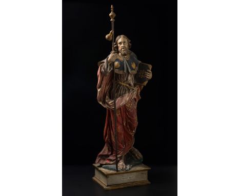
Lot 41
DOLORES RODEIRO BOADO (Galicia, 1853-1898)."Saint James the Apostle".Carved and polychrome wood.Measurements: 113 x 47 x 28 cm.The image of Saint James the Apostle, whom we recognise by his attributes such as the book, the wooden reed with the gourds and the shells on the front of his cloak. Aesthetically, the work follows the stylistic precepts of the Baroque, as can be seen in the treatment of the fabrics that make up the tunic, or the volume achieved by the artist in the waist area. However, the face and hair reveal that this is a 19th-century work. Little is known of Dolores Rodeiro Boado's biography. She was one of the youngest daughters of the Compostela sculptor Francisco Mª Rodeiro Permui, an artist who worked in the second and third thirds of the 19th century. Except for a pause in her training when she moved to Madrid in 1884, where she studied Antique Drawing and Antique Modelling at the School of Fine Arts, her artistic education was linked to her father. In 1875 he obtained an Honourable Mention at the Regional Exhibition in Santiago de Compostela, for a Crucifix and a Saint Ignatius of Loyola.James of Zebedee or James the Greater was one of the first disciples to shed his blood and die for Jesus. A member of a family of fishermen, brother of John the Evangelist - both nicknamed Boanerges ('Sons of Thunder') because of their impulsive temperaments - and one of the three closest disciples of Jesus Christ, the apostle James was not only present at two of the most important moments in the life of the Christian Messiah - the transfiguration on Mount Tabor and the prayer in the Garden of Olives - but was also part of the small group that witnessed his last miracle, his resurrection on the shores of Lake Tiberias. After Christ's death, James, passionate and impetuous, formed part of the initial group of the early Church in Jerusalem and, in his evangelising work, he was assigned, according to medieval traditions, the Spanish peninsular territory, specifically the northwestern region, then known as Gallaecia. Some theories suggest that the current patron saint of Spain arrived in the northern lands via the uninhabited coast of Portugal. Others, however, suggest that he travelled along the Ebro valley and the Cantabrian Roman road, and there are even those who claim that Santiago reached the Peninsula via what is now Cartagena, from where he set out on his journey to the western corner of the map.
Lot 16
INDIAANDERSON (JOHN CORBET) To India and Back by the Cape. By a Traveller... Subscriber's Copy, FIRST EDITION, AUTHOR'S PRESENTATION COPY, inscribed 'Joseph Menear from the Author, with very kind regards and best wishes for himself & family, Sutton, Surrey, October 7th, 1875' on the title-pages, list of subscribers, 19 lithographed plates with tissue guards, illustrations in the text including a map hand-coloured in outline, opening gathering working loose, light dampstain to one corner of approx. 10 plates, 3 with short marginal tear, publisher's blue pictorial cloth gilt, g.e., corners worn, some loss to spine [Abbey Travel 524; Mendelssohn IV, p.510], 4to, Croydon, John C. Anderson, 1859Footnotes:Author's presentation copy of his self-published guide book for travellers to India, dedicated to 'widows and orphans of English soldiers who have fallen... upon the plains of Hindostan', and illustrated with fine views including Ceylon, Madras, Calcutta, Bombay, Mauritius, Madeira and Tristan da Cunha.This lot is subject to the following lot symbols: •• Zero rated for VAT, no VAT will be added to the Hammer Price or the Buyer's Premium.For further information on this lot please visit Bonhams.com
Lot 17
INDIACRAWFURD (JOHN) Journal of an Embassy from the Governor-General of India to the Court of Ava, in the Year 1827... With an Appendix, Containing the Description of Fossil Remains, by Professor Buckland and Mr. Clift, FIRST EDITION, 5 aquatint plates (3 hand-coloured), 5 lithographed plates, one engraved plan, one large folding engraved map (short tears at fold), wood-engraved illustrations in the text, without half-title, modern half calf, spine tooled in gilt within raised bands, gilt morocco lettering label [Abbey Travel 405], 4to (270 x 202mm.), Henry Colburn, 1829Footnotes:John Crawfurd was sent as an envoy to Burma in 1826 with the aim of establishing a permanent British residency there, and forming good relations with the Court of Ava. Whilst he 'revealed little capacity as a negotiator... the book he wrote about his experiences, published in London in 1829, proved to be of exceptional value' (Howgego, Encyclopaedia of Exploration 1800 to 1850, 2004).This lot is subject to the following lot symbols: •• Zero rated for VAT, no VAT will be added to the Hammer Price or the Buyer's Premium.For further information on this lot please visit Bonhams.com
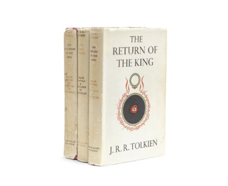
Lot 229
TOLKIEN (J.R.R.)The Lord of the Rings, 3 vol., FIRST EDITION, FIRST IMPRESSIONS, with 'sagging text' on p.49 of 'The Return', each with a folding map printed in red and black, publisher's red cloth ('Fellowship' slightly rubbed with a few spots on upper cover), dust-jackets (unclipped, age soiling to spines, 'Return' and 'Two Towers' with slight wear at extremities of spine and corners of folds, 'Fellowship' with spine soiled and frayed at extremities, split at lower joint, lower cover soiled with a couple of spots towards gutter margin, upper inner flap detached), 8vo, George Allen and Unwin, 1954-1955Footnotes:Provenance: Rachel Bromwich, ownership inscription dated 1954 on front free endpaper of The Fellowship; by descent to the present owner, with her name and short note beneath that of Rachel.This lot is subject to the following lot symbols: •• Zero rated for VAT, no VAT will be added to the Hammer Price or the Buyer's Premium.For further information on this lot please visit Bonhams.com
![TOLKIEN (J.R.R.)[The Lord of the Rings], 3 vol., FIRST EDITION, fourth impression of 'The Fellowship of the Ring', second im](https://cdn.globalauctionplatform.com/8371dcd4-571c-4dd7-83f9-aeae010c756c/b12a843b-3dfe-4e8e-be03-aeae0111e4cc/468x382.jpg)
Lot 230
TOLKIEN (J.R.R.)[The Lord of the Rings], 3 vol., FIRST EDITION, fourth impression of 'The Fellowship of the Ring', second impression of 'The Two Towers', first impression of 'The Return of the King', folding map at end of each volume, slight damp-stain to top edges and browning to endpapers of second and third books, publisher's red cloth (damp-stain to top and bottom of spine and adjoining corners of covers), dust-jackets (some staining, spines a little browned and chipped), 8vo, George Allen & Unwin, 1955This lot is subject to the following lot symbols: •• Zero rated for VAT, no VAT will be added to the Hammer Price or the Buyer's Premium.For further information on this lot please visit Bonhams.com

Lot 27
BRITISH ISLESLILY (GEORGE) Britanniae insulae quae nunc Angliae et Scotiae regna continet cum Hibernia adiacente nova descriptio, double-page engraved map, land masses hand-coloured, title cartouche and 2 other panels with descriptions of Ireland and Britain, borders trimmed with loss of the one-line border at right-hand margin, horizontal margins extended with old paper margins [Shirley 63; Tooley 271], 410 x 544mm., Rome, Sebastiano di Ré, 1558This lot is subject to the following lot symbols: •• Zero rated for VAT, no VAT will be added to the Hammer Price or the Buyer's Premium.For further information on this lot please visit Bonhams.com

Lot 28
BRITISH ISLESSPEED (JOHN) The Kingdome of Great Britaine and Ireland, hand-coloured double-page engraved map, inset views of London and Edinburgh, decorated with putti, ships, compass and scale, Royal coat-of-arms, and sea monsters, English text on verso, central vertical strengthened with paper strip on verso, a few small repairs, shaved close to printed rule border, 385 x 520mm., J. Sudbury and George Humble, 1610 [or slightly later]This lot is subject to the following lot symbols: •• Zero rated for VAT, no VAT will be added to the Hammer Price or the Buyer's Premium.For further information on this lot please visit Bonhams.com

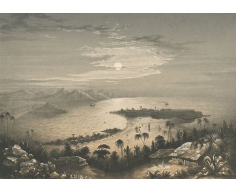
Lot 30
CHINA - BEIJINGCHUNG TUNG LITHO WORKS. Map of Peking, large colour lithographed map of Beijing/Peking, the title cartouche in Chinese and English, integral key in Chinese, a few place-names on map given in roman letters, framed and glazed by Wah-Cheong of Hong Kong [OCLC 961384049], sheet to view 760 x 525mm., Tientsin, Printed at Chung Tung Litho Works, 1914Footnotes:RARE MAP OF BEIJING, with a distinguished provenance.Provenance: George Ernest Morrison (1862-1920), or ''Chinese Morrison' or 'Morrison of Peking', as he was known, was one of the greatest newspaper correspondents of his age' (ODNB). In 1897 he was appointed as resident correspondent of The Times in Peking (Beijing), and during his twenty years in the post he visited every province of China; his youngest son, Colin G.M. Morrison, with typed label on verso of frame 'Private Property of C.G.M. Morrison, The Secretariat, Hong Kong, May 1957'; by family descent to current vendor.This lot is subject to the following lot symbols: •• Zero rated for VAT, no VAT will be added to the Hammer Price or the Buyer's Premium.For further information on this lot please visit Bonhams.com
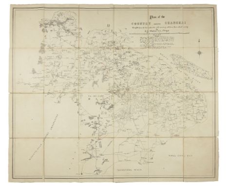
Lot 31
CHINA - SHANGHAIWATERS (THOMAS JAMES) Map of the Country Around Shanghai. Compiled from the Best Authorities with Numerous Additions from Actual Survey, large lithographed map, dissected into 20 sections laid on linen, a few waterways hand-coloured in blue ink, several place names added and others underlined in red pencil, map total dimensions 845 x 933mm., overall sheet 862 x 960mm., [?Shanghai, c.1880]Footnotes:Scarce map of Shanghai, OCLC citing only 2 copies, made by Thomas James Waters (1842–92), a civil engineer from Ireland who resided in Shanghai from 1878 to 1885, having previously worked extensively in Japan. A note records that the 'map extends to the limits of canal naviagation south of the Yangste river'.This lot is subject to the following lot symbols: •• Zero rated for VAT, no VAT will be added to the Hammer Price or the Buyer's Premium.For further information on this lot please visit Bonhams.com
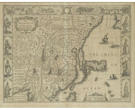
Lot 32
CHINASPEED (JOHN) The Kingdome of China, Double-page engraved map, 8 costumed figures in side borders, 4 scenes (including views of Macao and Quinzay) in upper margin, all over toning and light spotting, 395 x 510mm., Thomas Bassett, and Richard Chiswell, 1626 [but 1676, or later]Footnotes:Provenance: George Ernest Morrison (1862-1920), or ''Chinese Morrison' or 'Morrison of Peking', as he was known, was one of the greatest newspaper correspondents of his age' (ODNB). In 1897 he was appointed as resident correspondent of The Times in Peking (Beijing), and during his twenty years in the post he visited every province of China; his youngest son, Colin G.M. Morrison, with typed label on verso of frame 'Private Property of C.G.M. Morrison, The Secretariat, Hong Kong, May 1957'; by family descent to current vendor.This lot is subject to the following lot symbols: •• Zero rated for VAT, no VAT will be added to the Hammer Price or the Buyer's Premium.For further information on this lot please visit Bonhams.com

Lot 33
COLLINS (GREENVILLE)Great-Britain's Coasting Pilot: Being a New and Exact Survey of the Sea-Coast of England and Scotland, engraved pictorial frontispiece, title printed in red and black, 49 engraved charts (mostly double-page, 2 folding including Thames Estuary), one large engraved map in the text, damp-staining throughout, tears to several plates at lower fold (small loss of image to plate 15, Bristol Channel), 2 or 3 with old pencil annotations, nineteenth century manuscript index bound in before titles, paper tabs ('Chart' and numerals 1 to 49) pasted on verso of maps, contemporary calf over boards, defective [ESTC T166525, citing BL copy only; Shirley M.COLL-li], folio (525 x 330mm.), Mount and Page, 1785Footnotes:Scarce edition, ESTC citing the British Library copy only, of a collection of coastal maps, with a short introductory text, first published in 1693 and now expanded with additional charts including the Thames Estuary.Provenance: John Andrews, No.66, Church St., Broadway, Rotherhithe, eighteenth century ownership inscription on inside front cover. Pasted above this are two printed receipts issued to Andrews in his capacity as Master of the Ship Mary, signed by the collector at the Port of Newry (5 May 1782, the ship en route for Alicante), and the Trinity House for the Light House of the Needles Point & Hurst Beach, I.O.W. (10 March 1787, the ship en route from London to Virginia). Andrews was a Ship Master based in Staithes, Yorkshire; John White, ownership inscription 'This book was originally Capt Cooks, now John White 1851. Purchased at Southampton, Octr. 9 1851'; Thomas White Ratsey, Cowes, inscription dated 1890; T.C.Ratsey, inscription dated 1937. The Ratsey family of Cowes established a ship building and sail making business in 1790, still extant today. These last three inscriptions on the blank verso of the final plate.This lot is subject to the following lot symbols: •• Zero rated for VAT, no VAT will be added to the Hammer Price or the Buyer's Premium.For further information on this lot please visit Bonhams.com
![[GARDNER (THOMAS)]Pocket-guide to the English Traveller: Being a Compleat Survey and Admeasurement of all the Principal Roads](https://cdn.globalauctionplatform.com/8371dcd4-571c-4dd7-83f9-aeae010c756c/5bef162a-c34e-4aa0-8333-aeae010f1950/468x382.jpg)
Lot 34
[GARDNER (THOMAS)]Pocket-guide to the English Traveller: Being a Compleat Survey and Admeasurement of all the Principal Roads and Most Considerable Cross-roads in England and Wales, 2 parts in 1, FIRST EDITION, title printed in red and black, letterpress preface and index leaves cut to size and re-margined to match map sheet size, of maps approximately 50 shaved at fore-edge just touching printed border and approximately 10 with either upper or lower border shaved, 2 or 3 with the edges frayed, final plate 100 with small loss to map in upper right corner, without the title to second part (as often), lacks covers [Chubb CXXXVII], small oblong 4to (185 x 290mm.), J. Tonson, and J. Watts, 1719Footnotes:A first edition of Gardner's atlas of one hundred strip maps reduced from John Ogilby's Britannia, 1675.This lot is subject to the following lot symbols: •• Zero rated for VAT, no VAT will be added to the Hammer Price or the Buyer's Premium.For further information on this lot please visit Bonhams.com

Lot 35
GREAT BRITAIN - HEPTARCHYSPEED (JOHN) Britain as it was devided in the Tyme of the Englishe Saxons Especially their Heptarchy, hand-coloured double-page engraved map, 14 vignettes in the margins showing scenes from Saxon history, compass rose, English text on verso, 385 x 512mm., John Sudbury and George Humble, [1627, or later]This lot is subject to the following lot symbols: •• Zero rated for VAT, no VAT will be added to the Hammer Price or the Buyer's Premium.For further information on this lot please visit Bonhams.com
Lot 36
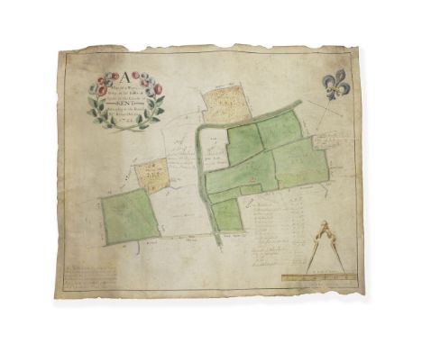
KENT – MANUSCRIPT ESTATE PLAN'A Map of a Farm lying in the Parish of Lydd in the County of Kent Belonging to the Reverd. Mr Richard Monins 1774.', manuscript map by Henry Maxted & Isaac Terry, surveyor, showing field names, footpaths, acreage and ownership, including 'A large wall leading out upon the Foreland', with additional list of acreages, further amendments showing adjacent land purchased by John Monins from neighbouring landowners in ink and pencil, calligraphic title within a floral cartouche in blue, pink and green, fleur-de-lis compass rose; a pair of surveyor's dividers with 'A Scale of Perches' at foot, framed with a black ruled border and embellished with green and yellow wash, on vellum, some dust-staining and loss to edges, rubbed, cockling, 480 x 585mm., 1744; together with a later manuscript map on paper of Dunspring Farm in the manor of Clayhall, Essex (2)Footnotes:The Monins family can trace their roots in the county of Kent to the time of the Conquest and through several marriages, became substantial landowners. The family rose in importance and office, providing several mayors of Dover and Lieutenants of Dover Castle as well as three MP's. The Reverend Richard Monins Easton was rector of Ringwould and Charlton in Kent, the son of Richard Monins, headmaster of King's School, Canterbury, from whom he inherited the living. He had died unmarried at the age of 36 in 1770 so our map would appear to have been commissioned at the bequest of his brother and heir, John Monins (b.1741), whose name also appears. A veteran of the American wars he retired from the army at the death of his brother and took up residence at Woodford in Essex where he had inherited property as well as the advowson of Ringwould. In 1777 he bought a property in Canterbury called the Archbishop's Palace on which he built a mansion called 'The Palace' (www.eastkenthistory.org.uk). The subject of our second map, Dunspring Farm was one of several farms comprising the manor of Clayhall in Essex which had passed into the Monins family through a distant relative, Miss Marland. The property remained in the Monins family until 1918.Provenance: John Monins (1741-1806); thence by descent.This lot is subject to the following lot symbols: ** VAT on imported items at a preferential rate of 5% on Hammer Price and the prevailing rate on Buyer's Premium.For further information on this lot please visit Bonhams.com
Lot 38
MOLL (HERMAN)Atlas Manuale: or, a New Sett of Maps of All the Parts of the Earth, as well as Asia, Africa, and America, as Europe... and the Coasts of all Countries are laid down, agreeable to Mr. Edmund Halley's Own Map, title printed in red and black, additional double-page engraved allegorical title, 32 double-page engraved maps (of 44), 3 partly hand-coloured, 3 with early manuscript notes in the margin, small loss to one corner of Brazil, piece of blank margin torn away from Italy, ink numerals on versos, occasional spot or small marginal stain, contemporary calf, rebacked [cf. NMM 395], rubbed, 8vo, J. Knapton, [and others], 1723--OWEN (JOHN) and EMANUEL BOWEN. Britannia Depicta: Or, Ogilby Improved. Being an Actual Survey of all the Direct and Principal Cross Roads of England and Wales, 273 engraved maps printed recto and verso, some shaved within the platemark but only touching printed area on map contemporary calf gilt, rebacked [Chubb CLVI], small 4to, Carington Bowles, 1764 (2)This lot is subject to the following lot symbols: •• Zero rated for VAT, no VAT will be added to the Hammer Price or the Buyer's Premium.For further information on this lot please visit Bonhams.com
Lot 39
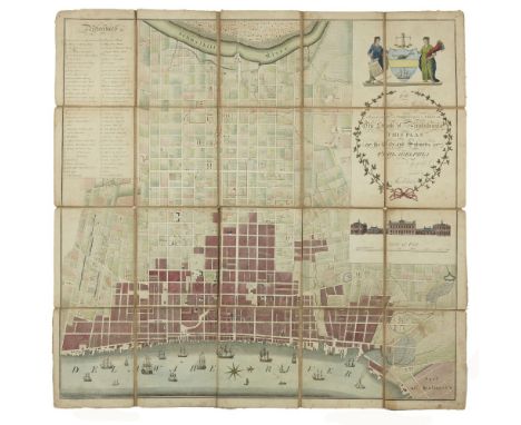
PHILADELPHIAFOLIE (A.P.) To Thomas Mifflin Governor and Commander in Chief of the State of Pennsylvania this Plan of the City and Suburbs of Philadelphia is Respectfully Inscribed by the Editor, 1794, engraved hand-coloured map by R. Scot and S. Allardice after Folie, dissected into 20 sections mounted on linen, title within decorative border of ivy leaves, index to points of interest, coat of arms held by two female figures, light surface soiling, a couple of sheets slightly loosened, inked 'Pensylvania, 1794' on verso, map 660 x 670mm., overall sheet size 680 x 690mm., [Philadelphia, 1794]Footnotes:The first large-scale map of Philadelphia, covering the area from the Delaware to the Schuylkill rivers. Major locations noted include the 'Jewish Synagogue', 'Jews Grave Yd.', 'African Meeting House', 'Bank of the United States' (and those of North America, and Pennsylvania), 'Peales Museum', 'Circus', 'State House, Congress Hall & City Courth House', 'Presidents House', and 'University'.This lot is subject to the following lot symbols: •• Zero rated for VAT, no VAT will be added to the Hammer Price or the Buyer's Premium.For further information on this lot please visit Bonhams.com
-
109182 item(s)/page