![Middle East.- Ruscelli (Girolamo) Arabian Felice Nuova Tavola [Arabian Peninsula], Ptolemaic map of the Arabian Peninsula bas](https://cdn.globalauctionplatform.com/b2e0cc76-940f-48a0-b6c7-ae3600f31b48/871f93c5-f0b4-42e4-90ba-ae3600f651d6/468x382.jpg)

Lot 143
Middle East.- Ruscelli (Girolamo) Arabian Felice Nuova Tavola [Arabian Peninsula], Ptolemaic map of the Arabian Peninsula based on the 1548 map of Giacomo Gastaldi, engraving with hand-colouring, on laid paper without watermark, platemark 192 x 265 mm (7 5/8 x 10 1/2 in), sheet 225 x 325 mm (8 3/4 x 12 3/4 in), Italian text verso, central vertical fold with careful repairs verso, minor surface dirt, unframed, [Venice, 1561-1599].


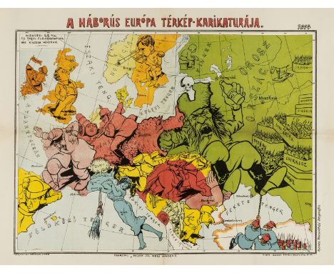
![Europe.- Hadol (Paul) A New Map Designed for 1870 [or] Carte Drolatique D'Europe Pour 1870 Dressee Par Hadol, serio-comic map](https://cdn.globalauctionplatform.com/b2e0cc76-940f-48a0-b6c7-ae3600f31b48/271f46a0-3c8c-45e6-a60b-ae3600f6268b/468x382.jpg)

![NO RESERVE Greece.- Visscher (Nicolas) Hellas [Greek] Seu Graecia Universa, engraving with original hand-colouring, 495 x 600](https://cdn.globalauctionplatform.com/b2e0cc76-940f-48a0-b6c7-ae3600f31b48/dbbe3989-a668-4925-8909-ae3600f6a48b/468x382.jpg)


![Middle East.- Ruscelli (Girolamo) Tabula Asiae VI [Arabian Peninsula], Ptolemaic map of the Arabian Peninsula engraving with](https://cdn.globalauctionplatform.com/b2e0cc76-940f-48a0-b6c7-ae3600f31b48/17dde0c7-cccb-46d4-9001-ae3600f5d184/468x382.jpg)


![Ireland.- [Bellin (Jacques Nicolas)] Carte Réduite des Isles Britanniques Cinquieme Feuille Contenant L'Irlande, large map an](https://cdn.globalauctionplatform.com/b2e0cc76-940f-48a0-b6c7-ae3600f31b48/16b89f85-900e-40c8-ad1e-ae3600f69d76/468x382.jpg)


![Europe.- War of the Spanish Succession.- [Plan of the Siege of Menen], broadside with large engraved plan showing the fortifi](https://cdn.globalauctionplatform.com/b2e0cc76-940f-48a0-b6c7-ae3600f31b48/11c6ac3b-bc98-4752-b9c4-ae3600f6a1a9/468x382.jpg)


