We found 109182 price guide item(s) matching your search
There are 109182 lots that match your search criteria. Subscribe now to get instant access to the full price guide service.
Click here to subscribe- List
- Grid
-
109182 item(s)/page


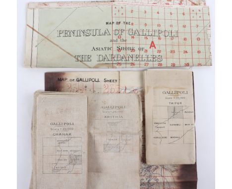
Lot 127
Important Collection of Original Gallipoli Maps, includes Gallipoli Sheet 1, 1:40,000 showing the Straits, the Forts, and Cape Helles together with a number of key locations c.80cms x 65cms, linen with some ink staining, (features and names still clear), Gallipoli Chanak, 1:20,000 dated 1915, shows Krithia and Chanak Kale and much detail, linen, Gallipoli, Taifur, 1:20,000, north section of Peninsular dated 1915, paper map, Excellent map of Gallipoli Krithia, 1:20,000 1915, shows Lancashire Landing, Gully Beach & Helles, c.75cms x 40 cms, linen, also Official map "Map of Peninsular of Gallipoli and Asiatic Shore of the Dardanelles" 1:63,000, showing whole Peninsular in colour dated War Office 1908, (updated as some point) stamped cancelled with map of Palestine 1918 on reverse. Slight loss at one fold (area of sea and section South of Straits), linen. Unusually good grouping of 5 original Gallipoli maps,
Lot 129
WWI Trench Linen Maps of Mesopotamia, Fat-hah, (GHQ) 3 inch to 1 mile with a large number of numbered Trenches shown both sides of the Tigris just below Fat-Hah, very detailed and in good condition. The second and third Trench maps show a similar area with a different scale of 1 inch to 1 mile, one dated 15-10-18 & the other 11-5-18. The fourth Trench map is of Tikrit (TC 199), 3 inches to 1 mile, very detailed showing trenches, artillery and MG's West of Tikrit on the Tigris, with pencil annotations. All very good condition (4)


Lot 178
Alfred Austin Lamia’s Winter-Quarters with colour plates 1907 first edition decorated cloth, Sacheverell Sitwell Golden Wall and Mirador 1961, G.W. Steevens In India with map 1909, A Second Book of South African Flowers 1936, The Ancient Explorers with maps 1929, Hard Road to Klondike 1962 etc (10)

![[Shropshire] Printed Maps of Shropshire AD 1577-1900 by Geoffrey Cowling, Robert Baugh’s Map of Shopshire 1808 with introduct](https://cdn.globalauctionplatform.com/1293449b-58d3-49c6-ba4e-ab6d0118aecb/2ddf992b-336d-4b04-8250-ab84011cc743/468x382.jpg)
Lot 216
[Shropshire] Printed Maps of Shropshire AD 1577-1900 by Geoffrey Cowling, Robert Baugh’s Map of Shopshire 1808 with introduction by Barrie Tinder the individual parts housed in slipcase, Shropshire Arms & Lineages by The Rev. Kittermaster 1869, Wenlock in The Middle Ages, All Round The Wrekin by Walter White 1860, A History of Tong Shropshire with Notes on Boscobel by George Griffiths Illustrated 1894 and a copy of Boscobel & Its Visitors 1910 (7)
![[William Morris & Merton Abbey] Rural Rides by William Cobbett published Reeves & Turner 1885 in 2 volumes with a fro](https://cdn.globalauctionplatform.com/1293449b-58d3-49c6-ba4e-ab6d0118aecb/e237fa2e-6e1e-412d-84dc-ab84011cddab/468x382.jpg)
Lot 234
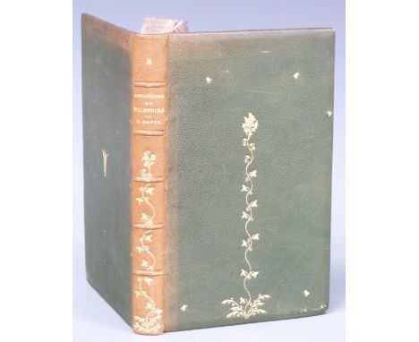
General View of the Agriculture of Wiltshire Drawn up and Published by Order of The Board of Agriculture by Thomas Davis 1811 first edition with portrait and a folding hand-coloured map bound in half leather with raised bands and gilt titles and decoration, The Flora of Wiltshire comprising the Flowering Plants and Ferns indigenous to the County by Thomas Bruges Flower (Parts 1-9) with several parts signed by author, bound in half leather with raised bands, gilt title and decorated spine (2)
![[Arabia] The Modern Traveller A Description Geographical, Historical and Topographical of the Various Countries of The Globe](https://cdn.globalauctionplatform.com/1293449b-58d3-49c6-ba4e-ab6d0118aecb/5293d4ea-f6c8-4077-b6f4-ab84011cf30c/468x382.jpg)
Lot 242
[Arabia] The Modern Traveller A Description Geographical, Historical and Topographical of the Various Countries of The Globe by Joshua Conder this being Volume the Fourth in the series on Arabia, published by James Duncan 1830 with folding map and plates, bound in half leather with gilt title labels & blind stamped decorated panels on spine, housed in slipcase, offered with an English-Arabic & Arabic-English Dictionary in cloth boards with gilt leather spine (2)

Lot 256
A New Map of The River Thames from Thames Head to London from entirely New Surveys made personally by the Author and corrected to the present time combined with guides giving every information required by The Tourist, The Oarsman and The Angler by Henry W. Taunt (c1880) Sixth Edition with folding maps and original photographs tipped-in bound in full leather with gilt illustrations and titling, Alfred Williams Round About The Upper Thames 1922 and Folk Songs of The Upper Thames 1923 (3)
Lot 257
General View of the Agriculture of the County of Devon with Observations on the Means of its Improvement drawn up for the consideration of The Board of Agriculture and Internal Improvement by Charles Vancouver, printed for Richard Philips 1808 first edition with folding hand-coloured map, tables and 28 engraved plates (some folding and hand-coloured), bound in boards with paper covered spine & printed label (binding worn) and Discourses Explanatory of the Object And Plan of the Course of Lectures on Agriculture and Rural Economy by Andrew Coventry 1808 in boards (2)
![[Exploration] Fighting The Polar Ice by Anthony Fiala illustrated from photographs by the author also eight from paintings, i](https://cdn.globalauctionplatform.com/1293449b-58d3-49c6-ba4e-ab6d0118aecb/6569fc17-928f-4e29-9f37-ab84011d0e14/468x382.jpg)
Lot 258
[Exploration] Fighting The Polar Ice by Anthony Fiala illustrated from photographs by the author also eight from paintings, in colour, published Hodder & Stoughton 1907 first English edition with folding map at rear in gilt cloth, Discovery of The North Pole by Dr. Frederick A Cook and Commander Robert E. Peary illustrated 1909 and Finding The North Pole illustrated 1909 publishers cloth (3)
Lot 260
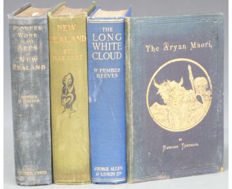
Pioneer Work in the Alps of New Zealand A Record of the First Exploration by Arthur P. Harper with Maps & Illustrations 1896, first edition in publisher's cloth, The Long White Cloud (Ao Tea Roa) by The Hon. William Pember Reeves Illustrated 1924, The Aryan Maori by Edward Tregear 1885 inscribed by author to Earl of Pembroke and New Zealand by Max Herz with 81 illustrations and map, publisher's cloth (4)
![[New Zealand] Ko Nga Mahinga A Nga Tupuna Maori He Mea Kohikohi Mai Na Sir George Grey Govenor in chief of The New Zealand Is](https://cdn.globalauctionplatform.com/1293449b-58d3-49c6-ba4e-ab6d0118aecb/e2432874-79be-477e-8db4-ab84011d1a67/468x382.jpg)
Lot 266
[New Zealand] Ko Nga Mahinga A Nga Tupuna Maori He Mea Kohikohi Mai Na Sir George Grey Govenor in chief of The New Zealand Islands, 1854 first edition, The Maori King by J.E. Gorst 1864 with folding map & portrait bound in leather, A Dictionary of the New Zealand Language by William Williams 1852 and An Old New Zealander, or Te Rauparaha by T. Lindsay Buick 1911 in gilt cloth (4)
![[Canals & Waterways Birmingham] Georgiii III Regis Anno Tricesimo Septimo, various Canal Acts for Dudley 1776, 1785, 1790](https://cdn.globalauctionplatform.com/1293449b-58d3-49c6-ba4e-ab6d0118aecb/c82d7806-cfae-4350-b8a5-ab84011d33a0/468x382.jpg)
Lot 283
[Canals & Waterways Birmingham] Georgiii III Regis Anno Tricesimo Septimo, various Canal Acts for Dudley 1776, 1785, 1790, 1793, Act for 1767 a Canal from Hawford to Claines, Droitwich Canal Junction 1852, Acts for Stourbridge Extension 1837, Act 1858 for the Birmingham Canal to Raise Money, Act of 1854 to make New Canals in Birmingham, Act of 1846 London & Birmingham Arrangement, Act 1844 for borrowing money etc etc. the Acts bound into 4 volumes, The Late Francis Duke of Bridgewater A Collection of the Several Acts relating to The Canals in boards (worn) with a Folding Map of Canals and Navigable Rivers in England & Wales Engraved for Potts' New Gazetteer

Lot 305
The Hobbit or There and Back Again by J.R.R. Tolkien Illustrated by the Author, published George Allen & Unwin 1955 7th impression with colour frontispiece and several black & white illustrations bound in publisher's decorated cloth with map endpapers and in original colour illustrated (split) dust-wrapper
Lot 323
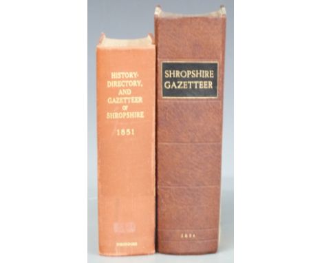
The Shropshire Gazetteer, with an Appendix Including A Survey of The County and Valuable Miscellaneous Information, with plates printed & published by T. Gregory 1824 first edition with various engravings and a folding map by John Cary, bound in recent half-leather with History, Gazetteer and Directory of Shropshire by Samuel Bagshaw 1851 rebound and lacking map (2)
Lot 326
Travels Through The States of North America And The Provinces of Upper And Lower Canada, During The Years 1795, 1796 and 1797 by Isaac Weld Junior, Illustrated and Embellished with Sixteen Plates of Maps & Views printed for John Stockdale, Piccadilly 1799 first edition rebacked in leather with raised bands over original leather boards, lacking one plate and with several tears to folding hand-coloured map
Lot 328
General View of the Agriculture of Wiltshire Drawn up and Published by Order of The Board of Agriculture by Thomas Davis, printed for Richard Phillips 1811 first edition with portrait, folding hand-coloured map and engraving of a Wiltshire ram and bound in full morocco with raised bands, gilt decorated floral designs on cover and spine with gilt title
![[Geology] The Geology of England And Wales with Notes on the Physical Features of the Country by Horace B. Woodward, publishe](https://cdn.globalauctionplatform.com/1293449b-58d3-49c6-ba4e-ab6d0118aecb/593d8948-f675-42d2-a451-ab84011c5348/468x382.jpg)
Lot 342
[Geology] The Geology of England And Wales with Notes on the Physical Features of the Country by Horace B. Woodward, published 1887 second edition with map and illustrations, in original gilt lettered cloth with two signed letters from the author dated 1879 & 1887 acknowledging receipt of an unknown specimen, he discusses a new publication to include cliff-sections. In the other letter he is unsure if a survey will ever publish his notes on the county around Chelmsford, Billericay etc (one tipped-in at rear & other loose)
![[India] Narrative of a Journey Through The Upper Provinces of India from Calcutta to Bombay 1824-1825 (with Notes upon Ceylon](https://cdn.globalauctionplatform.com/1293449b-58d3-49c6-ba4e-ab6d0118aecb/61b188e3-cf74-4597-9a43-ab84011c6f2d/468x382.jpg)
Lot 356
[India] Narrative of a Journey Through The Upper Provinces of India from Calcutta to Bombay 1824-1825 (with Notes upon Ceylon) An Account of a Journey to Madras and the Southern Provinces 1826, and Letters Written in India by the Late Right Rev. Reginald Heber, published John Murray 1828 first edition in 2 volumes with 9 (of 10) plates, wood engravings and folding map, bound in half leather with ornate gilt decorated spine & title (2)


![[Fantasy] Prince of The Blood by Raymond E. Feist 1989 signed copy, The Druid of Shannara by Terry Brooks 1991 signed copy, T](https://cdn.globalauctionplatform.com/1293449b-58d3-49c6-ba4e-ab6d0118aecb/1a095fba-893e-4fe3-b09f-ab84011c3d68/468x382.jpg)
Lot 141
[Fantasy] Prince of The Blood by Raymond E. Feist 1989 signed copy, The Druid of Shannara by Terry Brooks 1991 signed copy, Terry Pratchett Unseen Academicals 2009, Night Watch 2002, and The Wee Free Men 2003, J.R.R. Tolkien The Silmarillion 1977 with map, Anya Seton Avalon 1966, Preiss & Reaves Dragonworld 1979, Brian Jacques The Long Patrol, L.E. Modesitt The Order of War and 2 others, most in dust-wrappers (12)


Lot 270
Anglesey, Speed (John), Anglesey Antiently called MONA, Described 1620, with decorative title cartouche upper left and plan of Beaumaris upper right, Thomas Bassett & Richard Chiswell, hand coloured engraved map,[1676 or later], mounted, Hogarth framed and glazed with text verso, 57 x 71cm overall

Lot 273
Breconshire, Speed (John), Breknoke Both Shyre And Towne described, with decorative title cartouche upper left and plan of Breknoke (Brecon) upper right, Sudbury & Humble, [1616 or later] hand coloured engraved map, mounted, Hogarth framed and glazed with text verso, 57 x 71cm Provenance: Previously the Parker Gallery, with old paper label verso

Lot 453
Germany, Speed (John); A Newe Mape of Germany, newly augmented, a hand coloured engraved map, bordered by eight city views above and with ten characters in costume flanking, decorative cartouche lower left, published by G. Humble, Pops-Head alley, London, [bearing date 1626] mounted, framed and glazed and with English text verso, 44cm x 55cm overall


Lot 184
Ɵ Three various Hardy's Anglers' Guides, 50th, 55th & 61st Editions; The Oarsman's and Angler's Map of the River Thames, cloth bound; five various unused Fishing and Game records, and various other small books and fishing related journals etc.The estate of Christopher and Rosemary Warren Condition Report: Much worn. Potential purchasers must establish the exact condition in person.Condition Report Disclaimer

Lot 335
PAINTINGS AND DRY POINT ETCHING, to include 'Clay-Next-The-Sea, Norfolk' by James Priddey, signed and titled to lower margin, watercolours of Houses of Parliament, landscapes and riverscape, indistinct signature with paintings by Grace Scurlock, various subjects, nude female study initialled R.J and a map of the World, published by James Galt, 1966 (all framed)

-
109182 item(s)/page