We found 109182 price guide item(s) matching your search
There are 109182 lots that match your search criteria. Subscribe now to get instant access to the full price guide service.
Click here to subscribe- List
- Grid
-
109182 item(s)/page


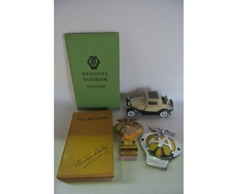
Lot 627
A selection of automobile related items to include a vintage brass Automobile Association badge and a further plated example, a vintage publication of The AA Members Handbook Ireland, and a further book This Motoring - Being the romantic story of the Automobile Association by Stenson Cooke, an AA route map of Barnstaple, AA membership card dated 1946 and a die cast model Ford Three Window 1932 Coupe

Lot 732
A collection of prints and engravings, relating to Bristol and its history including an 18th century black and white engraving showing Bristol High Cross by Samuel and Nathanael Buck and dated 1734, 48 x 30 cm, a reproduction 19th century lithograph showing Clifton with the Suspension Bridge, by Newman & Co and produced as a limited edition in 1973 by Alexander Gallery to commemorate the Bristol 600 anniversary of the granting of the City Charter, 36 x 49 cm, 19th century lithograph showing the Avon and Severn from Clifton Downs, by S C Jones, further topographical views, etc together with an 18th century map of France by T Bowen from Middleton's Complete System of Geography, 21 x 29 cm (all framed)

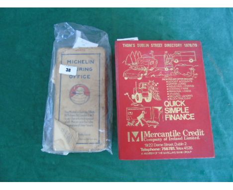
Lot 38
Irish Interest: Thom's Dublin Street Directory for 1978/79. Gilt-decorated red cloth covers. Containing many advertisements. Michelin Map of Ireland (Scale 3.15 Miles to 1 Inch) - Dublin - Birr (No. 28). And Michelin Map of the British Isles (Scale 3.15 Miles to 1 Inch) - Tipperary - Waterford (No. 30). Both coloured maps, cloth-backed, fold-out. No dates, circa early to mid-20th century. (3).
Lot 49
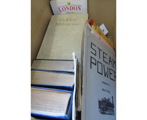
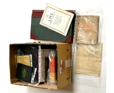
Irish Railways Today by Brendan Pender & Herbert Richards. Dublin: Transport Research Associates, 1967. The ABC of Irish Locomotives by R.N. Clements and J.M. Robbins. London: Ian Allan Ltd., 1949. Corus Iompair Eireann - Regulations for Train Signalling on Double and Single Lines (1952). And Silvermines Railtour, a souvenir brochure written by D. Donaldson. Also a Volume of Bradshaw's July 1922 Railway Guide (Published 1985), Handbook of Stuart Models, Two Volumes, October 1974 & July 1979. Both well-illustrated throughout. Both with fold-out Price List of Stuart Models. Locomotive Model Building & Similar Interest: Hornby Railways Magazine (no date, circa mid 20th century), Bassett-Lowke Model Railways and Their Equipment Catalogue (1938), Model Car Manual by G.H. Deason (1949), Model Equipment by W & H Models Catalogue, The Railroad Catalog From Microscale #10, Simple Cardboard Models by G.H. Deason (1969), Steam Power compiled by Alan King, Working Instructions & Price List of Spare Parts for Badmfords' Petrol Enginers, and Walthers 50th Anniversary Decal Catalog. Six Volumes of the Royal Automobile Club Guide & Handbook, The Earliest 1926-27, also 1949-50, 1950-51, 1953, 1958 & 1981. All containing advertisements, coloured and black & white scaled maps. Alao Golden Milestone - 50 Years of the AA, edited by David Keir and Bryan Morgan (London, 1955, first edition). The AA Conversation Handbook for Tourists, no date, circa 1950. Two Ordnance Survey (Scale 1/4 Incl to 1 Mile) Maps of Ireland - South East. A Shell Road Map of Ireland (Scale 1 Inch to 6 Miles). An iarnród éireann Distribution Fastrack Network Map of Ireland (Scale 1 to 350,000). And an AA Guide to London - What to See - Where to Stay.(Box)

Lot 74
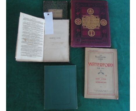
Irish Topographical, Maps & Guides: A Map of the County of Wicklow, Engraved by Sidney Hall from an original survey for Baldwin, Cradock & Joy. London October 15th 1822. Linen backed, in sleeve. 20.75 x 16.5ins., together with a larger linen backed Map of Wexford: Index to the Townland Survey of the County of Wexford. Pub. & Sold for her Majesty's Government by Hodges & Smith, Grafton St., Dublin. The Illustrated Guide to Waterford for 1917 (with a new Guide to Dungarvan). Oub. The Waterford News. Views of Wicklow & Killarney by W.J. Loftie. London: Marcus Ward 1876 Shamrock Leaves or The Wicklow Excursion with Notes. London: Longman, Hurst (etc) 1823. SCARCE (5). €80-120

Lot 76
Irish Topographical & Guides: Dublin and Its Environs: With a Map of the City. Dublin: James McGlashan 1846. Publishers inscription to fly leaf 'Eliza Bull, 37 Mt. Pleasant Avenue, With the Publishers Compliments'. SCARCE. Dublin's Hidden Wonders! by Sean Moynihan. Dublin Powell Press. N.d., Signed by the author and dedicated 'With the Compliments of the Author to Constance Fowers - a very kind and cultured lady indeed. Sean Moynihan'. Notes of a Trip to Ireland by Edwin Trueman. Newark: S. Whiles 1890. Irish Local Names Explained by P.W. Joyce. Dublin: Ed. Co. of Ireland 1923. Black's Guide to Galway, Connemara and the Shannon, and Lough Erne. With plan of Limerick. Edinburgh: Adam and Charles Black 1873. McComb's Guide to Belfast, The Giant's Causeway and Co. Down....... Belfast: McComb 1861. Photographic Album of Cork, Blarney and Queenstown, 24 Views. Sold W. Lawrence. Inscribed to back 'To Sweet Edith, In remembrance of my visit to the Isle of man, the pleasure of which was so much enhanced by her presence there. King of ire land, The Palace, Cork. 19/8/1891' Kilkenny - Kilkenny Junior Chamber. Kilkenny and the Black Abbey. Third Ed. (9).


Lot 51
Bradshaws Guides 1875 and 1940 together with an early 20th Century volume and a reprint of 1914; Railway Clearing House Map of England and Wales (Small Edition); York Newcastle & Berwick Railway Reid's Monthly Timetable 1849; Reid's Railway Guide (Jubilee Edition) 1899; NER Foolscap Memo Book; Locomotive Engineering and the Mechanism of Railways Vol 1 & 2 and a few other items

Lot 57
Railway Clearing House Map 1926 England (L&NER - GN Section) stamped 'LNER Southern Area' 48x58'', 122x147cm (F, some tears and staining) LNER Running Line Diagrams between Woodhouse & Cleethorpes and Clarboro Jnc & Lincoln (G-E) LM&SR General Instructions 'Curves', L&NER List of Lines with the Acts of Parliament Authorising Them, LNER Address book; together with a collection of Timetables flyers and a few other paper items (qty)

Lot 58
Railway Clearing House Official Hand Book Of Railway Stations &c, 1904 with two hand written inscriptions ''District Cashier's Office North Eastern Railway York, March 1912'' (G, some wear to cover) together with Official Railway Map of East of England with hand annotations 47x30'' 120x76cm and Midland & Great Northern Railways Joint Committee Map of Joint Lines 55x28'', 140x71cm (3)

Lot 62
Railway Publications A Collection Of Numerous Pre And Post BR Examples together with a small selection of railway related books, including Railwayman's Yearbooks, Official Guide to London and South Western Railway (also to GER, SECR and GNR); Timetables, Phillips New Railway Map, Royal Trains booklet, The Railway Centenary, Letters from the Baltic, The Coronation and other famous LMS trains and others (qty)

Lot 63
Railway Publications including Maintenance of Joint Lines containing numerous line maps, Joint Railways And Joint Stations LNER Southern Area, Hull and Barnsley Railway Working Time Table 1907 (with hard cover, Block Regulations 1903 (NER), NER Supplementary Appendix 1906-07, NER Quarterly Programmes 1903-04, GNR Proposed Widening Grantham to Doncaster with hand annotated map and GNR Loop & E L Section (8)

Lot 64
Railway Publications including NER Gradient Sections 1905 (two copies), GER List of Principal Gradients 1896, GER Lowestoft Harbour and Fish Markets General Bye-Laws and Regulations with map 1915, GER Diagram of Gradients and NER Distant Tables 1904 (condition varies, some F showing signs of wear) (6)


Lot 77
Various Railway Related Paperwork including L&NWR Diagrams of Private Sidings (Manchester to Leeds and Branches), M&GN Private Owner Sidings, Newcastle and District Key Plan (two part map) Railway Clearing House Map of England and Wales 1926 and a contemporary album of NER assorted paperwork including various letters and notices

Lot 329
W E Johns; Gimlet Lends A Hand; Gimlet Bores In; Gimlet Goes Again; Gimlet Off The Map; Gimlet Mops Up; Gimlet Gets The Answer and Gimlet's Oriental Quest, all first edition with dust wrappers, 12mo, together with King Of The Commandos, first edition with dust wrapper, 12mo, published by University of London Press, Bickley, Kent 1943. (8)

Lot 191
Ernest Herbert Whydale (1886-1956): drypoint etching of 'The Load', signed lower left, 26 by 30cm, together with a Richard Blome map of Warwickshire hand coloured, a pastel on paper portrait of an Airedale, two engravings showing Battle of the Boyne and Battle of Minden pub 1785 for Harrison's Editions of Rapin, a portrait of a man, and miscellaneous framed prints. (q)

Lot 1092
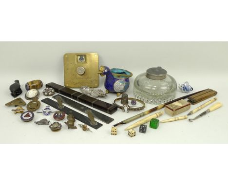
A quantity of collectibles, comprising; a hat rule, map measures, silver thimble, two ivory bobbins and button hook, a champleve vase in the form of a bird, a quantity of military badges, a brass Victorian trumps counter, a glass inkwell and quill, a cameo brooch, a miniature blue and white tea pot in the form of an elephant, a micro-mosaic brooch, and a pin cushion depicting West Cliff, Ramsgate.

Lot 146
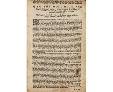
English . The Holy Bible , 2 parts in 1, titles in woodcut borders English . The Holy Bible , 2 parts in 1, titles in woodcut borders, royal arms on general title verso, without Apocrypha, Genealogies or map, small hole to title and next f., affecting border, upper corner frayed at start, touching title border, [Herbert 503], Robert Barker & Assignes of John Bill, 1636 bound with Whole Book of Psalmes (The), title in border, G.M. for the Companie of Stationers , 1636, in 1 vol., upper margin little trimmed, occasionally touching head line or pagination, some marking or browning, family information of the Elkingtons of Bath on fly-leaves and additional ff, contemporary black morocco, decorated in blind, gilt initials 'I G' on covers, later silver corner-pieces, rubbed, ends of spine worn, 8vo § Caxton (William, printer and translator ) - [Voragine (Jacobus de) Golden Legend], fragment only of a single column, one column only, of two, 55 lines, with part of the head-line, little marked, c 30 x 10 cm., [1483] § Reutsch (Antonius) Vade, & Mane Mecum Clericorum Saecularium, seu Varia Pia Exercitia, 9 engraved plates only, of 10, without no 1, bookplate of Alfred Edward A lston, contemporary black morocco, gilt, 12mo, Freiburg im Breisgau , 1746 (3).
Lot 167
A Collection of Theological Tracts , 6 vol (Richard, Bishop of Landaff ) A Collection of Theological Tracts , 6 vol., engraved map frontispiece, bookplate to front pastedown, contemporary half calf, Cambridge, 1785 § Huntington (William) The Select Works of the Late Rev. William Huntington, 6 vol., engraved portrait frontispiece, ink inscription to front free endpaper, hinges split and a couple of gatherings loose, contemporary half calf, 1837, some foxing and browning, extremities rubbed ; and a quantity of others, English Literature and Religion, v.s. (5 boxes)
Lot 181
Jones (William) - A Dictionary of Religious Opinions, top right corner of title removed, not affecting text, later half calf, 1815 § Newcome (William) An Attempt towards An Improved Version of the Prophet Ezekiel, ink signature partially removed from head of title, original cloth backed boards, printed paper label to spine, joints cracked but firm , 1836 § Witsius (Herman) and William Crookshank. The Economy of the Covenants , 2 vol., new edition, ink inscription to title and bookplate to front pastedown, contemporary cloth backed boards, spines torn with loss, joints split, 1837 § Mimpriss (R.) A Harmony of the four Gospels, second edition, engraved map hand-coloured in outline , original cloth, 1845 § Huntington (William) God The Guardian of the Poor, and the Bank of Faith, ink inscription to front free endpaper, contemporary half calf, 1846 § Philpot (J.C.) Memoir of the late William Tiptaft, ink inscription to title and bookplate to front pastedown, lower hinge broken, original cloth, gilt, faded , 1867, spotting and browning, extremities rubbed ; and a large quantity of others, on Religion, v.s. (10 boxes)
Lot 183
A Report on the Agriculture of Eastern and Western Flanders A Report on the Agriculture of Eastern and Western Flanders , hand-coloured engraved folding map, 11 engraved plates, some folding, offsetting, contemporary calf, covers detached, corners worn, rubbed, 1819 § [Lawrence (John)] The New Farmer's Calendar; Or, Monthly Remembrancer, for all Kinds of Country Business: Comprehending all the Material Improvements in the New Husbandry, with the Management of Live Stock, folding engraved frontispiece, offsetting on to title, library buckram, spine gilt, 1800 § Addresses Delivered on Different Public Occasions by His Royal Highness the Prince Albert, President of the Society for the Encourgament of Arts, Manufactures, and Commerce, advertisement f. at end, library buckram, 1857; and a quantity of others, 19th century Agriculture, ex-library copies, v.s. (Qty.)
Lot 242
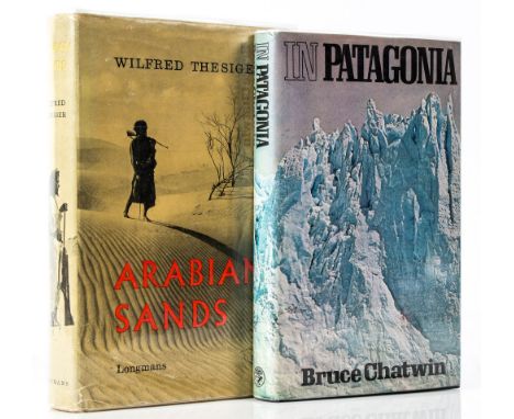
Chatwin (Bruce) - In Patagonia, first edition, first issue , map endpapers, photographic plates, original boards, lightly faded along upper edges, dust-jacket spine faded, 1977 § Thesiger (Wilfred) Arabian Sands, first edition , illustrations, small ownership sticker to front free endpaper, original boards, dust-jacket lightly rubbed and creased, 1959, 8vo (2)
Lot 27
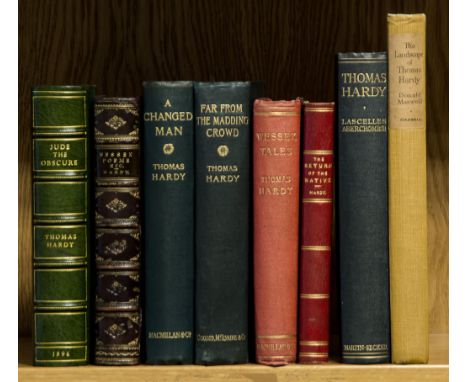
Hardy (Thomas) - Jude the Obscure, etched frontispiece, map at end, modern half green morocco, spine gilt and very slightly faded, 1896; Wessex Poems, [one of 500 copies], frontispiece, plates and illustrations by the author, contemporary half calf, spine gilt, rubbed, 1898; A Changed Man, photogravure frontispiece, double-page map and advertisement leaf at end, original green cloth, gilt, slight fading to lower cover, 1913, first editions ; and 5 others by or about Hardy, 8vo (8) The second is the author's first book of poetry.
Lot 306
Ransome (Arthur) - Coot Club, first edition , frontispiece and illustrations, including some full-page, errata slip, map endpapers (spotted), original cloth, dust-jacket, spine slightly faded, a little chipped at head and foot with a few short closed tears, light surface soiling, 1934; and a thrid impression of Pigeon Post, 8vo (2)
Lot 353
Minton (John).- Ross (Alan) - Time was away: a notebook in Corsica, first edition , map frontispiece, illustrations and plates, some colour, by Minton, map offsetting slightly onto title, bookseller's contemporary invoice loosely inserted, dust-jacket by Minton, a few closed tears with repairs to verso, some darkening and rubbing, wear to corners, small 4to , 1948.
Lot 365
Lewis (C. Day, translator) - the Aeneid of Virgil, signed limited edition 120/150, contemporary calf, gilt, slip case, marked and chipped, The Hogarth Press, 1952 § MacGillivray (William) The Natural History of Dee Side and Braemar, Presentation Copy, folding frontispiece map, text illustrations, contemporary half morocco, rubbed, Printed for Private Circulation, 1855, plus 1 other vol., 8vo (3)
Lot 422
Ireland.- Taylor (George) and Andrew Skinner. - Taylor and Skinner's Maps of the Roads of Ireland, surveyed 1777 , large folding engraved map or Ireland, engraved title and dedication, index, 288 engraved road maps on 144 leaves, list of subscribers at the end, large map lightly browned and offset with closed tear along lower margin, a few contemporary ink inscriptions to some of the road maps, light scattered spotting and light soiling, contemporary calf, boards detached, rubbed and worn, large 8vo, Dublin, W.Wilson, 1778.
-
109182 item(s)/page