We found 109198 price guide item(s) matching your search
There are 109198 lots that match your search criteria. Subscribe now to get instant access to the full price guide service.
Click here to subscribe- List
- Grid
-
109198 item(s)/page


![[Jansson (Jan)] Aegypti Recentior, Descriptio; Aegyptis & Turcis, Elchibith Arabibus Mesre and Misri, Hebraeis Mitsraim,](https://cdn.globalauctionplatform.com/48fedd08-502d-4726-bdca-acc2010be491/0ff9e605-8e00-4a6c-b40a-acda00de7187/468x382.jpg)


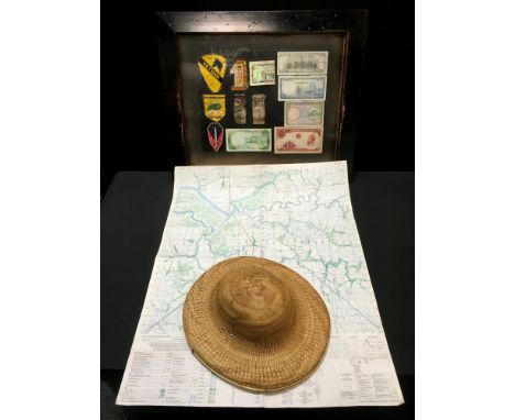
Lot 148
Pardoe (Miss) The Beauties of the Bosphorus; ....Illustrated in a Series of Views of Constantinople and its Environs, George Virtue, 1838, quarto, portrait frontis, engraved title with vignette, seventy-eight engraved plates as called for, engraved map (1839), all edges gilt, decorative morocco gilt (rebacked retaining original backstrip); Leon (Henri M.), Sheikh Haroun Abdullah, A Turkish Poet and His Poetry, being the Life of Sheikh Haroun Abdullah, Chief of the Mevlevi Dervishes ..., 1916, original cloth gilt [an interesting on-line article by Yahya Birt reveals that Leon was a pseudonym for Abdullah Quilliam]; with three others (5)
Lot 150
Sandys (George) A Relation of a Journey Begun An Dom: 1610. Foure Bookes Containing a Description of the Turkish Empire, of Aegypt, of the Holy Land, of the Remote Parts of Italy, and Ilands Adjoyning, W. Barrett, 1615, first edition, small folio in sixes, engraved title, folding map (torn with loss) with full facsimile map, facsimile dedication leaf, engraved text illustrations throughout, inscription to rear flyleaf, later endpapers, contemporary calf with blindstamped panels, joints worn with repairs to head and tail of spine

Lot 152
Simpson (G.C.) Scott's Polar Journey and the Weather, being The Halley Lecture delivered on 17 May 1923, Oxford: Clarendon Press, 1926, 31 pages, text illustrations including map frontis, original wraps (upper detached) [Rosove 310 A1] Quartermain (L.B.), Two Huts in the Antarctic, Wellington: Owen, 1963, plates as called for, original card wraps (2)
![Sheringham (H.T.) An Open Creel, Methuen, 1910, first edition, original cloth; 'Silver Doctor' [Lewis Smith], Angling from Ma](https://cdn.globalauctionplatform.com/48fedd08-502d-4726-bdca-acc2010be491/86d4af18-c41e-490c-b5fe-acda00de7747/468x382.jpg)
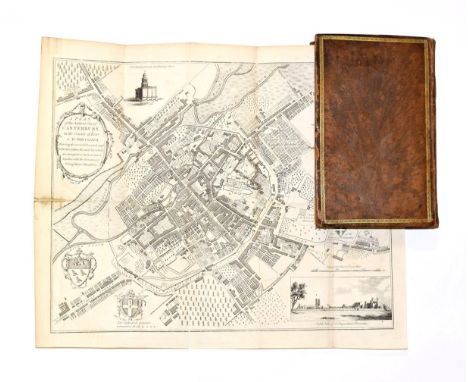
Lot 156
Sheringham (H.T.) An Open Creel, Methuen, 1910, first edition, original cloth; 'Silver Doctor' [Lewis Smith], Angling from Many Angles, privately published by the author's widow, plates as called for, original cloth; Watson (John), The English Lake District Fisheries, Lawrence and Bullen, 1899, plates as called for, folding map, original cloth; Reid (John), Clyde Style Flies and their dressings, David & Charles, 1971, first edition, illustrations as called for, dust wrapper; with twenty-five others on fishing (29)
Lot 21
Dale (Harrison) Ireland, A&C Black, 1927, 32 colour plates of illustrations by A. Heaton Cooper, map in text, dust wrapper (price-clipped); Palmer (W.T.), The English Lakes Painted by A. Heaton Cooper, Adam & Charles Black, 1905, numbered limited edition of 250, signed by the artist, quarto, seventy-five colour plates with printed tissue guards, top edge gilt, original cloth; Kelly (R. Talbot), Burma, Painted and Described, Adam and Charles Black, 1905, first edition, seventy-five colour plates with printed tissue guards, folding map, top edge gilt, original decorative cloth gilt; with thirty-six others published by A. & C. Black, eight in dust wrappers. (39)

Lot 036
Map of Paraguay, a copy by A. Van. Krevelt, 16cm x 38cm, 1773, together with Map of the World, Bonne, 1780, 25cm x 42cm also A map of Tahiti from an Edition of Cook's Voyages, dated 1769, probably published circa 1774, overall size 17cm x 43cm, together with a map of Greece and Balkans by De Lamarche overall size 22cm x 28cm and An antique amethyst and pearl set pendant, length excluding drop 27mm.


Lot 96
First edition (1934) of The Cambridgeshire's 1914-1919 by Brigadier-General E. Riddell & Colonel M. C. Clayton. Published by Bowes and Bowes. Blue cloth cover with gilt embossed detail. No dust jacket. Foxing to both front and back inside covers. Discolouration to back inside cover and to first pull out map. Pencil marks and ink smudge mark to page 59. All photo printed pages and both maps complete.
Lot 933
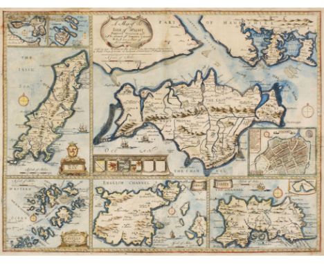
RICHARD BLOME - LINCOLNSHIRE, ENGRAVED MAP, C1673, HAND COLOURED, 33 X 27.5CM, A MINIATURE SPEED MAP OF WESTMORLAND AND CUMBERLAND AND A SIMILAR MAP OF THE ISLE OF MAN, AND SEVERAL UNFRAMED 18TH AND EARLY 19TH C, MAPS OF SCANDINAVIA AND A VANITY FAIR PRINT (11) Condition reportFirst map browned, the others in generally good condition, several with some faults


Lot 1
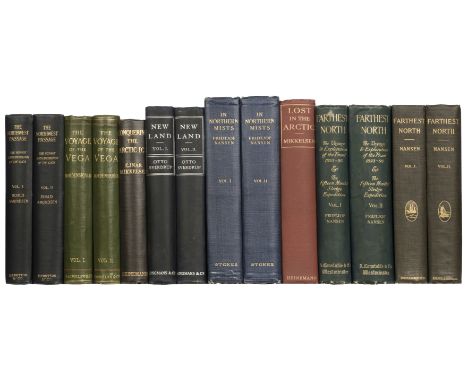
Amundsen (Roald). "The North West Passage", being the Record of a Voyage of Exploration of the Ship "Gjöa" 1903-1907, 2 volumes, 1st US edition, New York: E. P. Dutton and Company, 1908, frontispiece, 3 maps (2 folding), illustrations throughout, one folding map loose, tape residue to free endpapers, top edges gilt, original dark blue pictorial cloth gilt, short split to head of volume 1 front joint, 8vo, together with: Nordenskiöld (Adolf Erik). The Voyage of the Vega round Asia and Europe, with a Historical Review of Previous Journeys along the North Coast of the Old World. Translated by Alexander Leslie, 2 volumes, 1st edition in English, London: Macmillan and Co., 1881, half-titles, 5 steel-engraved portrait plates including frontispieces, 10 lithographic folding maps, one map (no. 10) with closed handling tear, numerous wood-engravings (many full-page), bookplate of Kenn Back, original green decorative cloth, 8vo, Mikkelsen (Ejnar). Conquering the Arctic Ice, 1st edition, London: William Heinemann, 1909, half-title, frontispiece, folding map, 2 maps and numerous further illustrations in text, Signet Library plate and inscription to front pastedown, manuscript call number to title-page verso, bookplate of Kenn Back to front free endpaper, tape residue to free endpapers, top edge gilt, original grey cloth, titles gilt to spine, polar bear vignette to front board, 8vo, Sverdrup (Otto). New Land. Four Years in the Arctic Regions. Translated from the Norwegian by Ethel Harriet Hearn, 2 volumes, 1st edition in English, London: Longmans, Green, and Co., 1904, half-titles, frontispieces, numerous illustrations (mainly photographic, including many full-page 'plates' counted in pagination), 40 pp. advertisements, 3 folding maps (2 in end-pocket), text-blocks toned, browning to half-title and final text-leaf of each volume from endpapers, volume 1 inner hinges cracked, volume 2 inner hinges neatly repaired, original blue cloth, vignette of the Fram to front boards in silver, library markings effaced from spines, headcaps refurbished, 8vo, and 4 others, all in original cloth (not collated): Nansen, In Northern Mists, 2 volumes, 1st US edition, New York, 1911, Farthest North, 2 volumes, 1st edition in English, London, 1897, Farthest North, 2 volumes, 1st US edition, New York, 1897; and Mikkelsen, Lost in the Arctic, 1st edition in English, London, 1913Qty: (14)NOTESTHE POLAR AND SOUTH AMERICAN LIBRARY OF BRITISH ANTARCTIC SURVEY METEOROLOGIST KENN BACK Arctic Bibliography 12443 (Nordenskiöld, misdating the translation 1882), 11421 (Mikkelsen, Conquering the Arctic Ice), 17322 (Sverdrup); cf. Arctic Bibliography 402 (Amundsen, first UK edition, Constable, 1908).
![[Stukeley, William]. An Account of a Roman Temple, and other Antiquities, near Graham's Dike in Scotland, 1st edition, [Londo](https://cdn.globalauctionplatform.com/77bc0ec2-9b7d-4928-a674-acd400a80e4f/0c52d854-69b4-4fdf-ab67-acd400ecabb3/468x382.jpg)
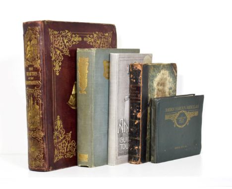
Lot 100
[Stukeley, William]. An Account of a Roman Temple, and other Antiquities, near Graham's Dike in Scotland, 1st edition, [London, 1720], 2 folding engraved plates, folding engraved map, all dated 1720, 27 pp., drop-head title, some light spotting and toning, blank leaves bound front and rear, binder ticket of Manderson, Brighton, all edges red, nineteenth century green half morocco, spine faded to brown and a little rubbed, some fading and light spotting to upper cover, 4toQty: (1)NOTESESTC T108883. Rare. William Stukeley's first published work. William Stukeley (1687-1765) was a pioneer in the field of British archaeology. He initially studied and practised medicine before being elected as a Fellow of the Royal Society in 1718, befriending Sir Isaac Newton among others (later writing Newton's biography in 1752 with the anecdote about the falling apple forming Newton's theory of gravity). He became interested in Roman Britain and undertook several field studies of Stonehenge and Avebury, linking their construction to the druids as opposed to the Romans (ancient field monuments were all supposed to have been built by the Romans in his day) and believing that the druids followed an earlier Abrahamic religion 'Patriarchcal Christianity'. The architect Andrews Jelfe (1690-1759) made the drawings from which the plates were engraved in 1719 on behalf of Stukeley at Arthur's O'on in Stenhousemuir in Scotland.
Lot 101
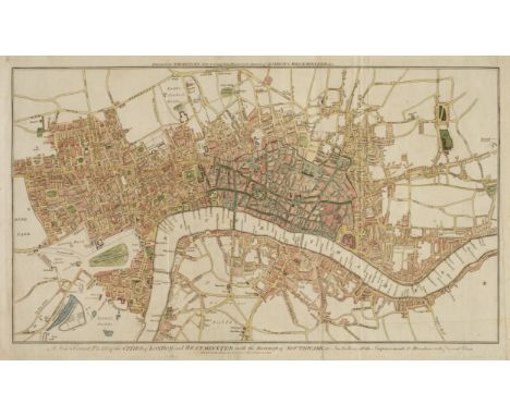
Thornton (William). The New, Complete, and Universal History, Description, and Survey of the Cities of London and Westminster, the Borough of Southwark, and the Parts adjacent, London: Alex. Hogg, and sold by all Booksellers in Great Britain, Ireland, France, America, East and West Indies, etc., [1784], 532 [4] pp., engraved frontispiece, 103 engraved plates (including maps, portraits and views), 2 engraved folding maps ('A New & Correct Map of the Countries upwards of Twenty Miles Round London' and 'A New & Correct Plan of the Cities of London and Westminster, with the Borough of Southwark', both hand-coloured), list of subscribers, toning, date effaced from title-page, maps creased and the first with repairs verso, contemporary manuscript genealogy to front free endpaper, related ownership inscription to title-page, contemporary calf, rebacked with original spine laid down, label renewed, worn overall, folio (38.2 x 23.2 cm), together with: Brand (John). The History and Antiquities of the Town and County of the Town of Newcastle upon Tyne, 2 volumes, 1st edition, London: B. White & Son, and T. and J. Egerton, 1789, xvi 676 [4], 723 [9] pp., engraved frontispiece and title-page to each volume, folding map, 30 engraved plates (including the plate at volume 1 p. 277, not listed; several folding), plates variably spotted and offset, contemporary diced russia, joints cracked at head, loss to head of spines, 4to (30.8 x 23 cm), Burlington (Charles, & others). The Modern Universal British Traveller; or, a New, Complete, and Accurate Tour through Scotland, and the Neighbouring Islands, London: J. Cooke, at Shakespeare's-head, 1779, pp. 836 [20], engraved frontispiece, 2 folding maps, 103 engraved plates (of 105: apparently without 'View of Shrewsbury' and 'Loch-Ranza Bay in Scotland'), one plate (St. Paul's Cathedral) folding, list of subscribers (cropped along fore edges), contemporary calf, rebacked with original spine laid down, worn, folio (35.5 x 22 cm), and 2 others, not collated (Lysons, Magna Britannia, volumes 2 and 4 [Cambridgeshire/Cheshire, and Cumberland], 1810-16)Qty: (6)NOTESProvenance (Brand): John Patrick Crichton-Stuart, 3rd Marquess of Bute (1847-1900), with his bookplates. ESTC T56039 (Thornton), T144797 (Brand), T110011 (Burlington); Howgego, Printed Maps of London (1979) 178 (1) and 179 (1) for the two maps in Thornton's work.
Lot 108
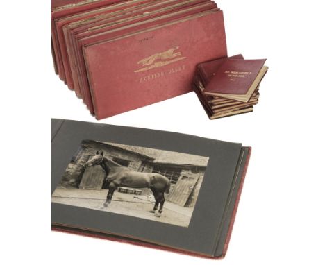
Pytchley Hunt. A comprehensive collection of 18 Sampson's Hunting Diaries created by William Wroughton, for the years 1879-1908, covering meets which took place between October 27th 1879 and April 6th 1908, including copious manuscript details of dates, locations, horses & pack hounds present and also general remarks regarding weather, location of hunt & foxes caught and also quality of the day in general, some volumes also containing numerous mounted/tipped-in & inserted newspaper clippings, a few related letters and photos, original maroon & red cloth, some soiling to covers of few volumes, oblong 8vo, with a card folder containing a few related booklets, letters and cuttings, including an interesting letter signed by Earl Spencer at Althorp to Harry Cazenove, dated 1st January 1971, together with: Foxhound pedigree record books, 14 foxhound pedigree books, 1898-1907, including one for Mr A. Mackenzie's Foxhounds, 1898, 10 foxhound pedigree books for Mr. Wroughton's Foxhounds 1899-1907 and two for Pytchley Hounds 1901 & 1903, and one other undated early 20th century puppy breeder's record book belonging to William Wroughton of Sudborough House, Thrapston, many of the pedigree books with manuscript additions, original maroon or dark brown morocco or sheep, mostly with titles in gilt to upper cover, bindings for 1904 & 1905 worn, 24mo (9.5 x 8 cm), with Hunt map, An early 20th century pocket folding hunt map covering the area of Pychley Hunt, supplied by Sifton, Praed & Co., Ltd., Mapsellers of St. James' Street, London, printed in colour, sectionalised & mounted to both sides on linen, cloth covered boards with ink stamp of H de L Cazenove to pastedown, printed paper label 'Pytchley Hunt' to upper cover, with a photograph album, A photograph album containing photographs of foxhounds, kennels, kennel hands and hunt members on horseback etc. (believed to be the Pychley Hunt and William Wroughton's Foxhounds), circa 1910, 18 mounted monochrome photographs (dimensions approximately 16 x 21 cm), original red cloth, oblong folioQty: (a carton)NOTESThe Pytchley Club was formed in 1750, the first Master being Earl Spencer of Althorp, Northamptonshire (the original pack having been established at Althorp in 1635). From 1819 to 1873 the Althorp and Pytchley countries were hunted by one pack with a second pack established at Brigstock and until 1920 the master of the Pytchley was in charge. The Hunt had a succession of Masters, including William M. Wroughton who was Master of the Pytchley Hunt from 1894-1902 and compiler of these diaries. The Pytchley country used to include areas of the Rockingham Forest but was split to form the Woodland Pytchley Hunt in 1931. Today, it covers an area of western and central Northamptonshire characterised by rolling hills, hedgerows and small areas of woodland. The country in which the Pytchley Hunt takes place is described in Baily's Hunting Directory 1939-1949, London: Vinton & Co. Ltd., 1948 as "the country, which lies in Northants and Leicestershire, extends some 20 miles N. to S. and 25 miles E. to W. On the N. it adjoins the Fernie, the Woodland Pytchley, and Atherstone; on the W. the Atherstone, N. Warwickshire, and Bicester; on the S. the Grafton and Oakley, and on the E. the Woodland Pytchley. It is impossible to describe its characteristics in a sentence. It is a very strongly fenced, often undulating country, and, as a whole, it normally consists of almost uninterrupted pasture. However, due to present agricultural policy, there is a considerable increase in arable land. A "bad horse cannot get over the country at all, and a second-class one will only spoil your pleasure and ruin your nerve" ("Brooksby"). He must be the best hunter bred; bold, fast, a big jumper, temperate, and able to stay... “. A copy of this volume is included in the lot.


Lot 118
Asia. Munster (Sebastian), Asia wie es Jetziger Zeit nach den Furnemesten Herrschafften Abgetheilet und Beschriben ist, S. Petri, Basel, circa 1588, uncoloured woodblock map, central fold toned, 325 x 365 mm, German text and an ornate woodblock design on verso,Qty: (1)NOTESPublished in the 'Cosmographia'.

Lot 119
Asia. Vandermaelen (Phillipe Marie Guillaume), Seven maps of Asia (nos. 98, Partie de la Chine, 106, Partie de la Cochinchine, 97, Tonquin, 99, Partie de la a. Chine, 105, Camboge et Anami, 47, Partie de l'Empire Chinois [&] 48, Partie de la Chine), circa 1825, together seven lithographic maps with contemporary outline colouring, each approximately 470 x 540 mmQty: (7)NOTESThe first map shows part of Southern China with Hainan, Canton and Macao, Lantau and Lamma Islands. Hong Kong is not named but appears as two islands. Originally published in Vandermaelen's 'Atlas Universel'.

Lot 12
FitzRoy (Robert). Narrative of the Surveying Voyages of His Majesty's Ships Adventure and Beagle, between the Years 1826 and 1836, describing their Examination of the Southern Shores of South America, and the Beagle's Circumnavigation of the Globe. Appendix to Volume II [i.e. one volume only, of 4], 1st edition, London: Henry Colburn, 1839, retaining the 6 engraved plates but without the 2 maps folding in end-pocket '(Track Chart' and 'Low Islands'), partly unopened, damp-staining to front free endpaper and to margins of title-page, light spotting to plates, bookplate (J. R. Minnitt of Annabeg), original blue fine-diaper cloth, spine faded, pale discolouration to lower inner corner of front board, 8vo, together with: Hooker (Joseph Dalton). Handbook of the New Zealand Flora, 1st edition, London: Reeve & Co., 1867, bookplate of Kenn Back, original cloth, short split to head of front joint, a bright copy, 8vo, Gilder (William H.). Ice-Pack and Tundra. An Account of the Search for the Jeannette and a Sledge Journey through Siberia, 1st UK edition, London: Sampson Low, Marston, Searle, & Rivington, 1883, wood-engraved frontispiece, plates and vignettes, 3 maps (1 folding), folding map spotted, original green pictorial cloth gilt, recased and relined, spine rolled, 8vo, and 7 others, 19th-century travel and sea voyages, including Dundonald, The Autobiography of a Seaman, 2nd edition, 1860 (original cloth, recased), Low, Report on the Dominion Government Expedition to Hudson Bay, 1st edition, 1906, and similarQty: (11)NOTESTHE POLAR AND SOUTH AMERICAN LIBRARY OF BRITISH ANTARCTIC SURVEY METEOROLOGIST KENN BACK

Lot 120
Austen & Co., Chicago (publishers). A Safety Guide for those contemplating a trip on the Sea of Matrimony, Chicago, 1906, two used postcards (with a 1908 post stamp) containing a photolithographic folding allegorical map, one map with a short split along old fold, each retaining the folding outer boards, each with a tongue and slit fastening, old folds, slight soiling to upper boards, each map 220 x 270 mmQty: (2)NOTESTwo early 20th-century comic matrimony maps, published as novelty postcards.

Lot 121
Azores & Atlantic Islands. Ogilby (John), Insulae Promontorii Viridis Hispanis Islas de Cabo Verde, Belgis De Soute Eylanden, circa 1670, hand coloured engraved map, large allegorical strapwork cartouche supported by Neptune and sea nymphs, central fold strengthened and repaired on verso, 250 x 315 mm, together with Bellin (Jacques Nicolas). Carte des Isles du Cap Verde, 1746, Paris, 1746, uncoloured engraved map, slight creasing, 230 x 300 mm, plus Bonne (Rigobert). Isles du Cap-Verd, Paris, circa 1780, hand-coloured engraved map, inset map of 'Plan de la Rade de la Praya', one small rust hole, repaired on verso, 245 x 360 mm, and Blanchford (Robert). A New Chart of the Azores or Western Islands from the best Authorities, Jany. 1st 1809, uncoloured 'blue-backed' chart engraved by S. Stockley, inset maps of the islands of St. Michael, Terceira and Fayal, four horizon profiles, toned overall, some creasing, long repaired closed tear affecting image, slight spotting, 560 x 740 mm, plus Don Vincente Tofino de San Miguel. Carta Esferica de Las Islas de los Azores ò Treceras..., 1788, uncoloured engraved sea chart, some ink annotations and the pencil addition of rhumb lines, slight creasing, 545 x 870 mm, with another 8 engraved maps, including examples by Mallet, Bonne, Bellin and Moll, various sizes and conditionQty: (13)

Lot 122
Barbauld (Anna Laetitia). A New Map of the Land of Matrimony drawn from the latest surveys, J. Johnson, 22nd August 1772, hand-coloured engraved miniature allegorical map, old folds, one repaired tear affecting the printed image, slight staining, 110 x 135 mm, together with Robaut (F. lithographer). Carte du Voyage Sur la Mer du Monde, circa 1860, an uncoloured allegorical lithographic map depicting a youthful voyage on the "Sea of the World", old folds, slight staining, 120 x 170 mm, with another copy similarQty: (3)NOTESThe first map described was published in two sizes - this being the smaller - and is sometimes found bound in with copies of Barbault's poem of 1775 "To Mr Barbauld, with a Map of the Land of Matrimony".

Lot 123
Blaeu (Johannes). Hantonia sive Southantonensis comitatus vulgo Hant-shire, Amsterdam, circa 1648, engraved map with contemporary hand-colouring, some worming to margins but not affecting image, 420 x 505 mm, French text on verso, together with Cantium vernacule Kent, Amsterdam, circa 1645, engraved map with contemporary hand-colouring, slight spotting and toned overall, 385 x 530 mm, with Middle-Sexia, Amsterdam, circa 1648, engraved map with contemporary hand colouring, stained, 390 x 405 mm, Latin text on versoQty: (3)
Lot 125
British Islands. Lea (Philip), A Map of the Isle of Wight Portsea Halinge, also the Islands of Jarsey & Garnsey which are part of Hampshire, George Willdey at the Great Toy Shop, Spectacle, China ware & Print Shop, circa 1730, hand-coloured engraved map of the Isle of Wight, inset map of Newport, surrounded by another six maps comprising of Jersey, Guernsey, The Scilly Isles, The Isle of Man, Holy and Farne Island, slight staining, repaired closed tears, some affecting image, central fold repaired on verso, the whole backed with archival tissue, 375 x 490 mm, together with Schenk (P. & Valk G.). Mona Insula vulgo Anglesey, Mona Insula vulgo The Isle of Man [and] Vectis Insula Anglice The Isle of Wight, Amsterdam, circa 1690, three engraved maps of one sheet (as published), contemporary hand-colouring and some later enhancement, some oxidisation to old watercolour causing the paper to crack, 445 x 545 mmQty: (2)
![British Isles. Mercator (Gerard), Anglia Scotia et Hibernia, Thomas Cotes, [1637], uncoloured engraved map, 180 x 135 mm, Eng](https://cdn.globalauctionplatform.com/77bc0ec2-9b7d-4928-a674-acd400a80e4f/4a67e38c-ae54-4072-ad6e-acd400ecbfa2/468x382.jpg)
Lot 127
British Isles. Mercator (Gerard), Anglia Scotia et Hibernia, Thomas Cotes, [1637], uncoloured engraved map, 180 x 135 mm, English text on verso, bound with another 16 maps and descriptive text of regions and countries comprising the British Isles, pages 45 - 120, lacking boards and spineQty: (17)NOTESPublished in the "Historia Mundi or Mercator's Atlas". R. W. Shirley, Early Printed Maps of the British Isles, 1477 - 1650, 476.

Lot 129
Cambridge. Braun (Georg & Hogenberg, Franz), Cantebrigia opulentissimi Anglie Regni urbs celeberrimi nominsis ab Academie conditore Cantabro cognominata..., [1575 or later], engraved map with contemporary hand colouring, large strapwork cartouche, slight fraying to margins but not affecting image, 335 x 450 mm, German text on versoQty: (1)NOTESOriginally published in 'Civitates Orbis Terrarum'.

Lot 131
Cheshire. Swire (W. & Hutchings W. F.), A Map of the County Palatine of Chester divided into Hundreds & Parishes from an accurate Survey made in the years 1828 and 1829, Henry Teesdale & Co. 1830, large scale engraved map with bright contemporary outline colouring, sectionalised and laid on linen, calligraphic cartouche, compass rose, table of explanation and an uncoloured vignette of the South West View of Chester Cathedral, slight offsetting and spotting, edged in green silk, silk a little frayed and detached in places, marbled endpapers, 965 x 1325 mm, contained in a contemporary calf book-box, box worn and frayedQty: (1)

Lot 132
China. Dorn (Frank), A Map and History of Peiping: formerly known as Peking..., 1st edition, Peiyang Press Ltd., Peiping, 1936, colour lithographic pictorial map of Peking, old folds, split along some folds, bound with the explanatory booklet within the publisher's paper slipcase, paper wrapper with closed tears and some fraying, 820 x 720 mmQty: (1)NOTESA pictorial and illustrative map showing the principal sites and occupations of the inhabitants, within a border giving a pictographic introduction to Chinese history from 1100 B.C. to 1927. The whole map is crowded with amusing vignettes of the life and sights of Peking ranging from the Forbidden City and the Old Execution Ground through to Pigeon Thieves, the Eunuchs' Cemetery, the Dog Temple, the Temple of Eighteen Hells and the Spider Pagoda. Frank 'Pinky' Dorn was an American artist, 'old China hand,' and military officer. Born in 1901 in San Francisco, he studied at West Point from where he was commissioned into the Field Artillery. He served in the Philippines from 1926 to 1929 and became an instructor at the Field Artillery School from 1930 to 1933. He moved to Beijing in 1934 where he studied Chinese. In WW II he was an aide to Brigadier General 'Uncle Joe' Stilwell in Burma from 1939 - 1942. From 1944 to 1945 he was the commander of the China Training and Combat Command. He retired in 1953 with the rank of Brigadier General and returned to San Francisco where he devoted the remainder of his life to painting. Dorn died in 1981 and was buried with full military honours at Arlington National Cemetery.

Lot 133
Conder (Thomas). The Journey of Life, or An Accurate Map of the Roads, Counties, Towns &c. in the Ways of Happiness & Misery, J. Buckland & W. Otridge, 18th Jany. 1773, hand-coloured engraved allegorical map after George Wright, old folds, one long repaired tear affecting image, 320 x 180 mmQty: (1)NOTESA rare allegorical map of the Journey of Life, which originally appeared as an addendum bound into George Wright's "Walking Amusements for Chearful Christians". The map has a high moral tone illustrated by two roads. One leading through Indifference, Obduracy and Impenitence to Hell, the other through Repentance, Faith and Perseverance to Heaven.
Lot 135
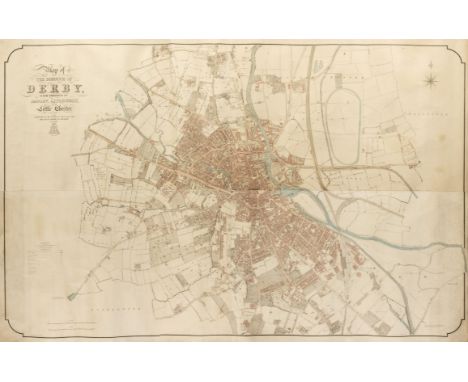
Derby. Standidge & Co., (lithographers), Map of the Borough of Derby, with portions of Darley, Litchurch and Little Chester, published for the Derby Board of Health by the Board of Ordnance, 1852, very large lithograph with contemporary outline colouring, on four conjoined sheets, laid on later canvas, slight staining and dust soiling, 1230 x 1910 mmQty: (1)NOTESA monumental plan of the city of Derby produced on the very large scale of 24 inches to the mile. A scarce plan of an expanding Victorian city shown in immense detail.

Lot 136
Dorset. Greenwood (C. & J.), Map of the County of Dorset from an actual survey..., Greenwood, Pringle & Co., 1826, large scale engraved map with bright contemporary hand colouring, sectionalised and laid on linen, uncoloured vignette of Weymouth, calligraphic cartouche, compass rose and table of explanation, slight staining and offsetting, edged in green silk (a little frayed), 1170 x 1570 mm, contained in a modern calf gilt book boxQty: (1)

Lot 138
England & Wales. Ortelius (Abraham), Angliae Regni Florentissimi nova Descriptio auctore Humfredo Lhuyd Denbygiense, circa 1595, hand-coloured engraved map, large strapwork cartouche and mileage scale, some marginal water staining, short split to central fold, 380 x 470 mm, Latin text on versoQty: (1)NOTESMarcel van den Broecke. Ortelius Atlas Maps, 19. Second state with the corrected mileage scale. R. V. Tooley, Early Printed Maps of the British Isles 1477 - 1650, 185.

Lot 139
England, Ireland & Wales. Speed (John), The Invasions of England and Ireland with al their Civill Wars since the Conquest, Thomas Bassett & Richard Chiswell, [1676], hand-coloured map engraved by Cornelius Danckerts, decorative cartouche, compass rose and numerous rhumb lines, slight creasing and some marginal water staining, closed tears affecting image but skillfully restored, 385 x 525 mm, English text on versoQty: (1)

Lot 14
Franklin (Sir John). Narrative of a Journey to the Shores of the Polar Sea, in the Years 1819-20-21-22, 2 volumes, 2nd edition, London: John Murray, 1824, half-titles, 4 engraved folding maps, volume 1 retaining final leaf (blank except for name of printer), volume 2 retaining directions to the binder leaf, upper fore corners of title-pages torn away, bookplates of Kenn Back, uncut in original boards, rebacked and relined, 8vo (22.6 x 13.4 cm), together with: McClintock (Sir Francis). The Voyage of the 'Fox' in Arctic Seas. A Narrative of the Fate of Sir John Franklin and his Companions, Twelfth Thousand, London: John Murray, 1860, 3 folding maps, all plates as called for 32 pp. advertisements, one folding map loose (originally in end-pocket), bookplate of Kenn Back, recent blue crushed half morocco by Period Binders of Bath, 8vo (22.1 x 13.5 cm), De Long (George W.). The Voyage of the Jeanette. The Ship and Ice Journals, 2 volumes, 1st edition, Boston: Houghton, Mifflin and Company, 1883, all plates and maps as called for, bookplate of Kenn Back, recent half calf by Period Binders of Bath, 8vo (23 x 13.5 cm), and 4 others, leather-bound (not collated): Franklin, Narrative, 2nd edition, 1824 (3 maps only, of 4); McClure, The Discovery of the North-West Passage, 1854 (ink-stamps; title-page loosening); Marryat, The Pirate, and the Three Cutters, 1836; Ross, Narrative of a Second Voyage in Search of the North-West Passage, Paris, 1835Qty: (10)NOTESTHE POLAR AND SOUTH AMERICAN LIBRARY OF BRITISH ANTARCTIC SURVEY METEOROLOGIST KENN BACK Arctic Bibliography 5195 (Franklin), 10557 (McClintock), 3839 (De Long, with date 1884).

Lot 140
English Channel. Jacobsz (Jacob, pseud. Lootsman), De Cust van Normandie en Picardie..., Amsterdam, circa 1644, engraved sea chart with early hand-colouring, orientated to the south, strapwork cartouche, compass rose and numerous rhumb lines, slight overall toning, together with another slightly later uncoloured example, each 430 x 530 mm, together with Seller (John). An untitled chart of the English Channel, circa 1680, uncoloured engraved chart of the eastern end of the Channel from Portsmouth to Dover, also showing the Normandy coastline, inset map of the Isle of Wight, one printer's fold, slight dust soiling, 525 x 415 mm, with Blaeu (W. J.). De Custen van Engelandt tusschen de droochte van Weembrugh en Poortlandt, circa 1623, uncoloured engraved sea chart centred on the Isle of Wight and showing the English coast from Portland Bill to Selsey, trimmed with slight loss to vertical margins, 265 x 35 mmQty: (4)

Lot 141
Estate plan. Singer (Joseph, Land Surveyor), A Plan of an Estate lying in the Parish of Frome Selwood and County of Somerset belonging to Mrs S. Haynes, 1779, large pen and watercolour estate plan laid on near-contemporary textured cotton, strapwork cartouche with a pen and ink vignette of a watermill, compass rose, table of explanation and a scale of chains and furlongs, the map is reticulated with an alphabetised key in the margins, some later pencil annotations, old folds, some creasing, slight surface abrasion but largely confined to margins, 875 x 970 mmQty: (1)NOTESAn unusually large estate plan centred on Keyford and Frome.

Lot 143
Europe. Munster (Sebastian), Europa Prima Nova Tabula, Basel, circa 1550, uncoloured woodblock map of Europe orientated to the south with a large galleon in the Atlantic ocean, central fold skillfully repaired on verso, 275 x 345 mm, Latin text within an ornate woodcut border on versoQty: (1)

Lot 146
Gillet (R., publisher). Allegorical Map of the Tract of Youth to the Land of Knowledge, 1st Feby. 1796, uncoloured engraved map, old folds, slight staining, 145 x 185 mmQty: (1)NOTESA scarce late 18th century allegorical map illustrating a young man's journey through life. Published in Robert Gillet's philosophical work "The Pleasures of Reason" [1796].

Lot 147
Greenwood (Charles & John). A collection of nine county maps comprising: Map of the County of Gloucester, Map of the County Palatine of Lancashire, Map of the County of Cambridge, Map of the County of Buckingham, Map of the County of Rutland, Map of the County of Huntingdon, Map of the County of Lincoln, Map of the County of Berks [and] Map of the County of Bedford, C. & J. Greenwood, [1834], together nine engraved maps with contemporary hand colouring, each with an uncoloured topographical vignette, calligraphic cartouche, compass rose, reference to the hundreds and table of explanation, the map of Lancashire with some offsetting and trimmed to neatline on the horizontal margins, the remainder are clean and bright with good margins, each approximately 620 x 700 mmQty: (9)NOTESThe maps were originally published in the 'Atlas of the Counties of England, from Actual Surveys, made from the years 1817 to 1833'.

Lot 150
Holy Land. Speed (John), Canaan. Begun by Mr John More continued and finished by John Speede, 1651, Thomas Bassett & Richard Chiswell, [1676], hand-coloured engraved map, inset plan of Jerusalem, central fold and lower margin strengthened and repaired on verso, slight toning to central fold, slight creasing, 390 x 525 mm, English text on verso, mountedQty: (1)NOTESThis highly decorative map was first published in 1627 in John Speed's 'Prospect of the World'. A meandering hatched path shows the exodus route taken by Moses as he led the Israelites out of Egypt, including an illustration of the parting of the Red Sea.
![India & Pakistan. Fries (Laurent), Tabula IX Asiae [title on verso], circa 1535, uncoloured woodcut map on a trapezoidal](https://cdn.globalauctionplatform.com/77bc0ec2-9b7d-4928-a674-acd400a80e4f/1cddc069-7946-480e-ab6f-acd400ecd285/468x382.jpg)
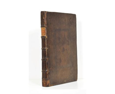
Lot 151
India & Pakistan. Fries (Laurent), Tabula IX Asiae [title on verso], circa 1535, uncoloured woodcut map on a trapezoidal projection, slight toning to central fold, some worming affecting printed image, 310 x 390 mm, Latin text on versoQty: (1)NOTESA Ptolemaic map of Pakistan and Western India, taken from Lorenz Fries' edition of Ptolemy's 'Geographia'. The map is derived from an earlier version of 1513 by Martin Waldseemuller.


Lot 154
Lancashire. Hennet (G.), A Map of the County Palatine of Lancaster Divided into Hundreds and Parishes from an accurate survey made in the years 1828 and 1829, Henry Teesdale and Co. May 1st. 1830, large scale engraved map with bright contemporary outline colouring, sectionalised and laid on linen, calligraphic cartouche, compass rose, table of explanation, uncoloured vignette of the New Custom House Liverpool, some offsetting and staining, marbled endpapers, edged in green silk, 1615 x 1130 mm, contained in a contemporary calf book-box with contrasting morocco gilt label to spine, box worn and rubbedQty: (1)

Lot 157
London. Lotter (Tobias Conrad), Delineatio ac Sinitima Regio Magnae, Brittaniae, Metropoleos Londini ad novissimam Norman repraesentata et exusa..., circa 1740, engraved map of London and its environs with contemporary hand-colouring, central fold crudely repaired at base, slight staining but largely confined to margins, one additional vertical crease, 500 x 580 mmQty: (1)
Lot 158
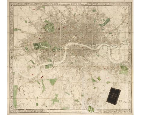
London. Stanford (Edward, publisher), Stanford's Map of Modern London and the Suburbs, May 9th, 1870, large engraved map with contemporary outline colouring, sectionalised and laid on linen, displayed on two sheets, uncoloured decorative floriate border, northern sheet 900 x 1730 mm, southern sheet 685 x 1730 mm, slight dust and finger soiling to margins, marbled endpapers, contained in a contemporary morocco gilt slipcase, worn and frayed with slight loss to the bottom panel.Qty: (1)NOTESA large scale and dramatic plan of London.

Lot 159
Maps. A collection of 30 British county, regional and country maps, town plans and charts, 17th - 19th century, including Speed (John). The Kingdome of Ireland devided into severall Provinces and then againe devided into Counties newly described, Roger Rea, 1662, hand-coloured engraved map, decorative strapwork cartouche and six costumed figures to the lower left margin, frayed and worn with some loss to the printed image, laid on later thin card, 385 x 505 mm, together with Bowen (Emanuel). An Accurate Map of the County of Kent devided into its Lathes and subdivided into Hundreds..., Robert Sayer & Carington Bowles, circa 1765, engraved map with contemporary outline colouring and some later enhancement, trimmed to neat line re-margined, some wear and closed tears, torn with slight loss and replaced in facsimile, 520 x 700 mm, with Ogilby (John). The Road from the City of Salisbury com. Wilts to Campden..., [and] The Road from London to Southampton, circa 1676, one coloured and one uncoloured engraved strip road map, The road from Salisbury to Campden worn and frayed with some loss to the printed surface, laid on later thin card, the road from London to Southampton trimmed to neatline on vertical margins with slight loss to the printed surface, margins extended, each approximately 315 x 465 mm, plus Blaeu (Johannes). Hantonia sive Southantonensis comitatus vulgo Hantshire [and] Vectis Insula, Anglice The Isle of Wight, Amsterdam, circa 1645, two engraved maps with contemporary hand-colouring, worn and frayed with some loss to the printed surface, crudely repaired on verso, 415 x 505 mm, French text on verso with another 34 maps, including examples by Cary, Lodge, Moule, Bowen, Bartholomew, Kitchin, Rocque, Baker, Archer, Weller, Seller/Grose, Henshall, Morden, Munster and Murdoch Mackenzie, various sizes and conditionQty: (40)

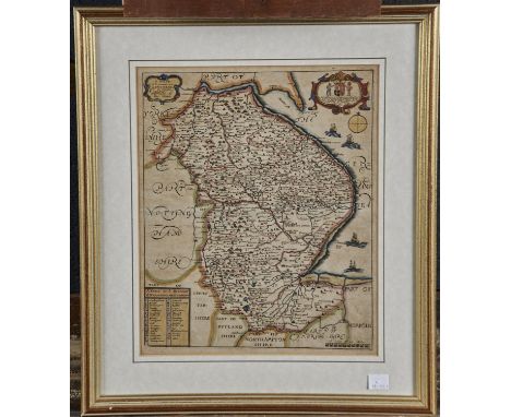
Lot 165
Nottinghamshire. Overton (H.), A New Map of Nottingham-Shire with the Post and Cross Roads and other remarks according to ye latest and best observations, 1714, engraved map with contemporary outline colouring, inset map of Nottingham, slight oxidisation to old watercolour, central fold strengthened and the verso backed with archival tissue, 355 x 505 mm, mountedQty: (1)NOTESUncommon.

Lot 166
Ogilby (John). A collection of 6 maps, The Road from Tinmouth in Northumberld to the City of Carlisle in Cumberld, The Continuation of the Road from St Davids to Holywell, The Road from St Davids com Penbroke to Holywell com Flint, The Road form Prestaine in com. Radnor to Carmarthen, The Road from London to St Neotts in com Hunt, continued to Oakeham in com. Rutland & The Continuation of the Road from Chester to Cardiff com Glamorgan, [1676 or later] , six uncoloured engraved strip road maps, some staining and spotting, each approximately 335 x 455 mmQty: (6)NOTESThe map sheet numbers are: 86, 67, 66, 84, 45 & 64.
-
109198 item(s)/page