We found 109198 price guide item(s) matching your search
There are 109198 lots that match your search criteria. Subscribe now to get instant access to the full price guide service.
Click here to subscribe- List
- Grid
-
109198 item(s)/page


![Antique map of Renfrew - Praefectura Renfroana by Timothy Pont and Joan Blaeu published 1654 [46x70cm]](https://cdn.globalauctionplatform.com/9f5f5c02-02c0-41b2-ba0c-af9000afdb7e/66321230-c342-4500-80d6-af92013b8768/468x382.jpg)
![[ Shipping ] A mid 20th Century Blue Funnel Line wall map, linen backed between pine battens, by Thomas Forman and Sons Ltd,](https://cdn.globalauctionplatform.com/dc205598-1f9c-4848-8f60-af8e010d4016/033f32c0-14ca-408f-8b85-af9000f13e95/468x382.jpg)

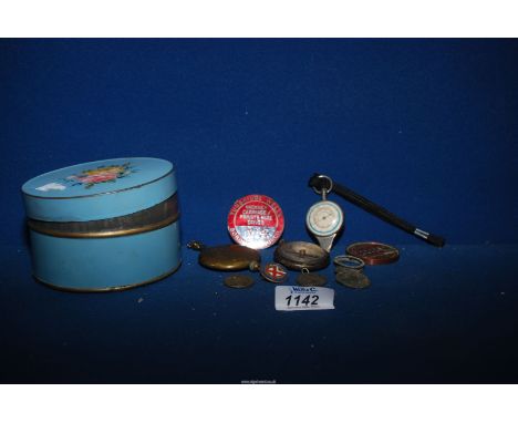
Lot 1147
A New and General Map of the Southern Dominions belonging to The United States of America, viz. North Carolina, South Carolina and Georgia; with The Bordering Indian Countries and the Spanish Possessions of Louisiana and Florida, watercolour tinted engraving, published by R H Laurie, 53 Fleet Street, London, 1823, bearing Graphic Arts Gallery label verso, in card mount and gilt frame under glass, 67 cm x 81 cm overall

Lot 1148
After John Senex (British, 1678 - 1740) "South America corrected for the observations communicated to the Royal Societys of London and Paris", an early 18th Century map of South America detailing the routes of various explorers with dedication to "Edmund Halley, Savilian Professor of Geometry in Oxford and fellow of the Royal Society", watercolour tinted engraving, engraved by Henry Hulsbergh, in fabric covered card mount and parcel craquelure gilt frame under glass, 84 cm x 117 cm overall


Lot 1152
After John Speed (British, 1551 - 1629) "A Mapp of the Sommer Ilands, Bermuda", a map detailing the division of the islands into tribes, polychrome print, originally engraved by Abraham Goos (c.1590 - 1643), 20th Century, in card mount and moulded oak frame under glass, 53 cm x 66 cm overall

Lot 1153
John Rapkin (British, 1813 - 1888) "Isthmus of Panama", a late 19th Century map of Panama including "The proposed railway and canal communications" and includes vignettes "The Fort at Charges" and "Gold seekers on their way to the Cordilleras" by Henry Warren, watercolour tinted engraving, published by John Tallis & Company, London & New York, engraved by John Rapkin and J Wrightson, in pen line card mount and Hogarth frame under glass, 48 cm x 41 cm overall


Lot 75
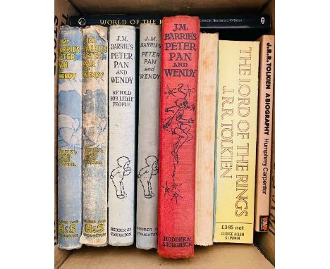
Tolkien, J. R. R. A collection of 11 books by or about Tolkien, to include The Father Christmas Letters, first edition, London: George Allen & Unwin, 1976, hardcover, plus The Silmarillion, by Christopher Tolkien, second impression, London: George Allen & Unwin, 1977, octavo, publisher's blue cloth, folding map at rear, price-clipped dust-jacket. Together with Barrie, J. M. Peter Pan and Wendy, illustrated by Mabel Lucie Attwell, five copies, various editions, earliest c. 1928, and Peter Pan in Kensington Gardens, illustrated by Arthur Rackham, 12th impression, 1948, London: Hodder & Stoughton. Condition varied, sold with all faults (18)


![[Defoe (Daniel)] The Life, And Strange Surprizing Adventures of Robinson Crusoe of York, Mariner...Written by Himself, fifth](https://cdn.globalauctionplatform.com/d4a463ec-c9f8-4a51-8059-af810104b01f/caffbbd9-e477-40ef-b052-af8101076b11/468x382.jpg)
Lot 132
[Defoe (Daniel)] The Life, And Strange Surprizing Adventures of Robinson Crusoe of York, Mariner...Written by Himself, fifth edition, engraved frontispiece, folding map of the world, 4pp. publisher's advertisements at end, 1720; The Father Adventures...Being the Second and Last Part, second edition, lacking map, 4pp. publisher's advertisements at end, 1719; Serious Reflections during the Life and Surprising Adventures...with his vision of the Angelick World, first edition, engraved folding plan of the island (substantial portion cut away and replaced with later paper), 2pp. publisher's advertisements at end, with catchword "The" on p.270, 1720, woodcut title vignettes, initials, head- and tail-pieces, book-label or ink ownership inscriptions to pastedowns, some light foxing or staining, contemporary panelled calf, vol. 1 & 2 uniform but vol. 3 differing slightly, worn at spine ends and corners (repaired in vol. 3), rubbed, [Moore 412; 417 & 436], 8vo, Printed for W. Taylor (3)⁂ A complete set of Defoe's classic tale of shipwreck and survival, often hailed as the first novel in the English language.
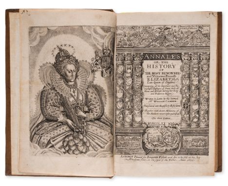
Lot 160
Camden (William) Annales, or the Historie of the Most Renowned and Victorious Princesse Elizabeth, third edition, engraved portrait frontispiece and additional title, lacking Z2 (but with duplicate of Z1) and final blank, [STC 4501], Printed by Thomas Harper, 1635, bound with Ligon (Richard) A True & Exact History Of the Island of Barbadoes, second edition, engraved map, 6 plates of natural history, 2 folding plates of sugar processing only (of 3) with the accompanying explanatory leaf bound at end, map and 1 folding plate torn and repaired with minor loss, some paper repairs with early ink manuscript visible to verso, 1 plate chipped at fore-margin with tiny loss to image, [Wing L2076], by Peter Parker...and Thomas Guy, 1673, together 2 works in 1 vol., bookplate of Vane Londonderry, a few instances of near contemporary ink marginalia, the odd small hole or short tear, occasionally affecting text, some light spotting or staining, particularly to plates, attractive later panelled calf, rubbed, joints starting with upper joint repaired at foot, folio.
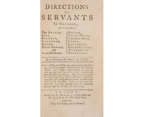
Lot 170
Swift (Jonathan) Directions to Servants in General, first London edition, final leaf soiled and with short tear affecting text (no loss), [Rothschild 2178; Teerink 785], R.Dodsley, 1745; Three Sermons..., second edition, variant with "Subordination" in final line of p.32, [Rothschild 2176; Teerink 70], R.Dodsley, 1744 bound after Kane (Richard) Campaigns of King William and Queen Anne..., first edition, with folding engraved map but lacking the plates, J.Millan, 1745 and Froissart (John) A Paralel of Times and Events..., first edition, C.Corbett, 1746, together 4 works in 1 vol., occasional soiling, contemporary mottled calf, rubbed, upper cover detached, 8vo⁂ Sammelband containing two works by Swift, most notably his celebrated satire on the behaviour of servants, published posthumously.

Lot 181
Irish binding.- Connellan (Owen) The Annals of Ireland, translated from the Original Irish of The Four Masters, chromolithographed additional pictorial title, heightened in gold, lacking folding map, some foxing, occasional staining, mint gilt floral endpapers, handsome contemporary dark green morocco, richly gilt, covers with shamrock centre-piece within ornate swirling tendrils, terminating in bird's heads or leaves, including shamrock, medieval church and cross corner-pieces at foot, all within triple filet borders, the outermost wider than others, spine in compartments and with red morocco label, profusely decorated with shamrocks and swirling tendrils, all within triple gilt filet borders, spine slightly faded, some staining, rubbed and marked, attractive gilt and dark green gauffered edges with shamrocks and tendrils, 4to (binding 284 x 236mm.), Dublin, Bryan Geraghty, 1846.

Lot 227
Le Carré (John) The Honourable Schoolboy, light scuffing to joints of dust-jacket, 8vo, 1977; Smiley's People, ink ownership name to pastedown, 1979, first editions, both copies signed by the author on titles, plain endpapers, original boards, light bumping to spine ends, dust-jacket, small nicks to spine ends, still very excellent overall, 8vo (2)⁂ The second and third titles in the Karla trilogy. There are two issues of The Honourable Schooboy with either map or plain endpapers, seemingly without any established primacy.
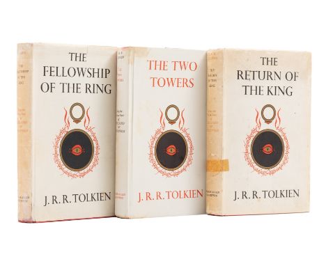
Lot 238
*** Please note, the description of this lot has changed. Tolkien (J.R.R.) The Lord of the Rings, 3 vol., comprising The Fellowship of the Ring, tape staining and browning to endpapers, cloth soiled, jacket faintly spotted with nicks to extremities and spines, tape repairs to spine recto and verso, jacket spine browned, 1954; The Two Towers, cloth rather soiled, jacket upper panel with two soiling marks and nick to corner but without general toning, extensive damp-soiling to lower panel and spine, with discolouration, mottling, and tears along joint with portion of loss, affecting endpapers and map at rear, spine hinge starting, 1954; The Return of the King, issued with signature mark '4' and text block sagging, cloth remarkably clean, jacket faintly spotted with nicks to extremities and spines, dark tape repair to spine, light shelf lean, 1955, first editions, first impressions, folding maps, original cloth, dust-jackets, 8vo.
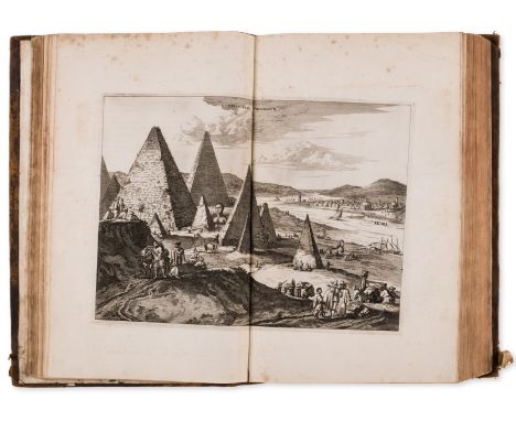
Lot 261
Africa.- Ogilby (John) Africa: being an accurate description of the regions of Ægypt, Barbary, Lybia, and Billedulgerid, the land of Negroes, Guinee, Æthiopia, and the Abyssines, first edition, engraved allegorical frontispiece, title in red and black, large folding double-page map of Africa, 43 engraved double-page maps, views, scenes and plans, 8 single-page plates, 9 sheets of letterpress tables (misbound), engraved initials, head-pieces and numerous illustrations to text, additional folding plate titled "Teneo te Africa" bound in at front, 2 facsimile maps bound in at rear, lacking half-title, map of Africa with tear at foot of inner margin and along horizontal fold, latter repaired but with small loss to image, several double-page plates with tear at foot of inner margin, most neatly repaired with paper to verso, slight creasing to a few plates, some light foxing or browning, armorial bookplate of William East, contemporary calf, rebacked, covers worn, rubbed, [Wing O163], folio, Printed by Tho. Johnson for the author, 1670.⁂ First edition of this important work on Africa, the most comprehensive work on Africa in English published in the seventeenth century, largely based on the work of Olfert Dapper. The letterpress tables, rather than being bound at the end of the preliminaries (as called for by Wing), are interspersed throughout the text.
Lot 262
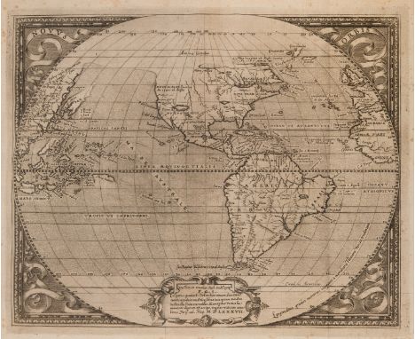
δ America.- Martyr d'Anghiera (Peter) De Orbe Novo, edited by Richard Hakluyt, collation: a⁸, A-Z⁸, Aa-Rr⁸, woodcut printer's device to title, woodcut head-pieces and initials, with the exceedingly rare engraved folding map of the New World, monogrammed 'LG' in ligature in lower left corner, possibly the French engraver Leonardo Gaultier, an excellent fine impression printing with light plate tone on 16th century laid paper with small spherical watermark [similar to Briquet 14056 and 14057, French, dateable to 1550s or slightly later], italic type, contemporary marginal annotation to leaf D1, some light foxing and browning, map with some light scattered spotting, mostly marginal, later parchment boards, ink title to spine, some soiling, spine darkened, 8vo (170 x 105mm.), Paris, Guillelmum Avvray, 1587.⁂ Peter Martyr's authoritative chronicle of the Spanish conquest of the Americas, edited by Richard Hakluyt as part of an ongoing enterprise to encourage England's competitive expansion into the New World. Published the year before the Armada, the work is dedicated to Sir Walter Raleigh, an apparent promotion for Hakluyt's cause. The Latin text is drawn from the 1530 edition of Martyr's text, the first to be published with all eight "Decades". The folding map, known as the Hakluyt-Martyr map, is a remarkable piece of cartography, exceedingly rare to find in its original situation. We cannot trace a copy appearing at auction with the map present in over a century. It covers North and South America, including part of Africa, Europe, and Pacific islands. New Guinea and Japan are shown partially blank. The overall shape of the coastline of America is greatly improved, eliminating the bulge to western South America commonly found in maps of the period. Most remarkable is the inclusion of "Virginea 1584", the first appearance of the name Virginia on a printed map. An area entitled "Nuevo Mexico" with a large inland lake is also the first use of this term on a printed map.Literature: Adams M753; Sabin 1552; Burden 63 for the Hakluyt-Martyr map. δ This lot is sold subject to Artists Resale Rights, details of which can be found in our Terms and Conditions.
Lot 263
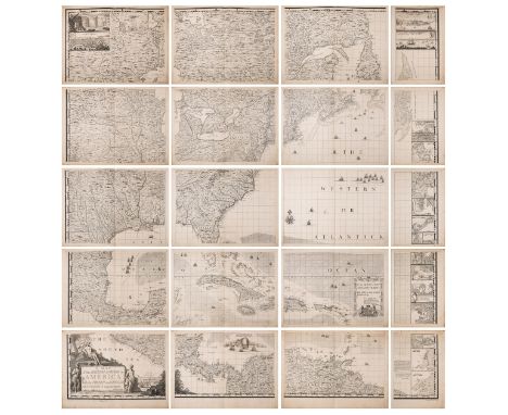
America.- Popple (Henry) A Map of the British Empire in America with the French and Spanish Settlements Adjacent thereto, engraved folding key map [Babinski state 4; showing the track line of Spanish Galleons], with large engraved wall map on 15 engraved double-page and 5 single-page map sheets, page numbers present, Harding and Toms imprint on map sheet 17 [Babinski state 7], with Tom's imprint present on map sheet 20 without Searle's name, all on cream laid paper with large Strasbourg Lily watermarks, wide margins, mounted on stubs, double page sheets each approx. 535 x 730 mm (21 x 28 3/4 in), single sheet maps each approx. 535 x 370 mm (21 x 14 1/2 in), some minor spotting and browning, occasional surface dirt throughout, minor toning to extremities of some sheets, printer's crease to sheet 17, minor marginal wormhole damage to a few sheets in the lower centre, well outside the platemarks, key map with some early marginal ink inscriptions, minor splitting to foot of fold, front free endpaper with ink gridlines, contemporary quarter calf and marbled boards, spine with losses, rubbed and very worn, folio, S. Harding and W. H. Toms, 1733 [but circa 1740]Provenance:Probably purchased by a Scottish merchant in the 1740s;Thence by descent to the present ownerLiterature:Babinski, Henry Popple's 1733 Map, 20-sheet map state 7⁂ One of most important large scale English maps of North America published in the 18th Century.Henry Popple's Map of the British Empire in America was originally intended as a means of refereeing the competing claims of the English, French and Spanish colonists and delineating their respective territories on North American soil. Popple lacked any formal training or experience as a mapmaker prior to this, his only known cartographic work. Accordingly, he made use of any available printed and manuscript maps he could get his hands on, consulting a variety of English and French sources; most notably Delisle's Carte de la Louisiane et du Cours du Mississippi, 1718, Guillaume Delisle's Carte du Canada, 1703 and the maps of Herman Moll. The resultant, monumental map - nearly eight feet squared when joined - bears witness to the rapidly growing knowledge of the interior of North America, with copies of Popple's map being sent to the governors of each English colony for official use."A fundamental centerpiece of any serious collection of North American maps" (Babinski, Henry Popple's 1733 Map, 1998, p. 151).

Lot 275
Middle East.- Speed (John) The Kingdome of Persia with the cheef Citties and Habites described, carte-de-figures map of the Persian Empire, with vignettes of Isphan, Hormuz, Tabris, and Tehran along the upper edge, with side panels of eight noblemen and citizens of Persia, engraving with full hand-colouring and heightened with gold, on laid paper, platemark 390 x 512 mm (15 1/4 x 20 1/4 in), under glass, minor handling creases and surface dirt, framed, George Humble, 1626.

Lot 277
Turkey.- Sandys (George) Sandys Travailes: containing a History of the Original and present state of the Turkish Empire: their Laws, Government, Policy, Military Force, Courts of Justice and Commerce, sixth edition, additional engraved title, folding engraved map, short split to fold, folding engraved panorama plate, illustrations, some full-page, engraved initials and head-pieces. manuscript notes in an early hand to title and margins with occasional fingerposts, trimmed, K2 repaired and strengthened at gutter, T1 with short closed vertical tear through text, spotting and staining, previous owner's ink name to early blank, upper hinge strengthened, near contemporary calf, faint remnants of text in manuscript to upper cover, repairs to corners, rubbed and worn, [Wing S678] folio, by R. and W. Leybourne, and to be sold by John Sweeting, 1658.

Lot 278
World.- Montgomery (Robert) Tallis's Illustrated Atlas and Moder History of the World, engraved frontispiece of the Great Exhibition (loose), engraved vignette title, 2 engraved comparative plates of rivers and mountains in the eastern and western hemispheres and 81 engraved maps with vignette illustration, all hand-coloured in outline, heavy spotting and surface dirt to frontispiece, otherwise some scattered spotting and surface dirt, minor toning, letterpress text accompanying map of Scotland with large tear, not affecting map, half calf, spine with black morocco labels, gilt, spine splitting with upper part of spine almost completely loose, lower cover detached, worn, small folio, 1851.
Lot 279
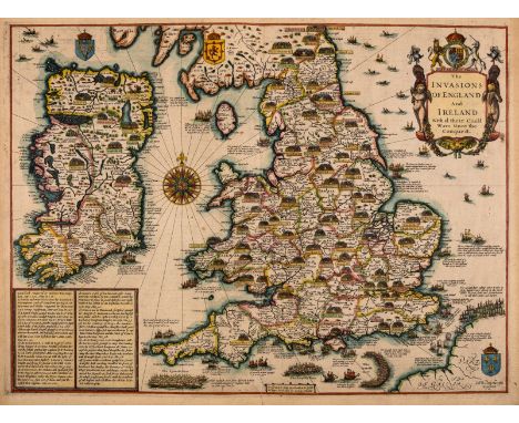
British Isles.- Speed (John) The Invasions of England and Ireland with al their Civill Wars Since the Conquest, First edition, decorative title cartouche surmounted by royal arms, upper right, naval battles in the Channel and North Sea, numerous land battles, large compass rose, arms of Scotland, Ireland and France, a text panel lower left, engraved map by Cornelius Danckerts, with hand-colouring, platemark 390 x 520 mm (15 1/4 x 20 1/2 in), sheet 413 x 557 mm (16 1/8 x 21 7/8 in), English text verso, central vertical fold with careful repairs to splitting verso, marginal nicks and tears, small marginal loss to upper left, some even toning with light exposure lines outside of borderline, unframed, George Humble, [1627-1632]
Lot 280
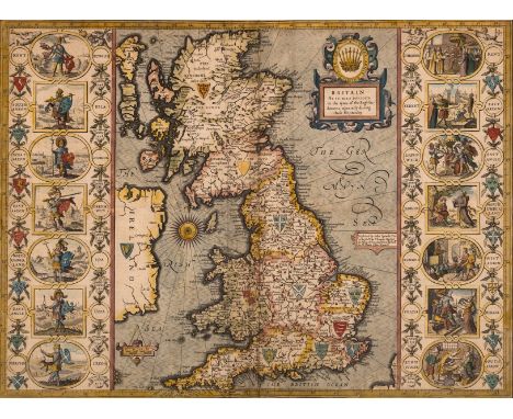
British Isles.- Speed (John) Britain as it was devided in the tyme of the Englishe Saxons especially during their Heptarchy, decorative map of the British Isles with compass rose and numerous rhumb lines, fourteen engraved vignettes of historical scenes and Saxon kings to the vertical margins, engraving with hand-colouring, on laid paper with watermark of fleur-de-lis, 385 x 510 mm (15 1/4 x 20 in), under glass, English text verso, central vertical fold with careful repairs and parallel creasing visible, marginal nicks and tears repaired verso, surface dirt, framed, Bassett & Chiswell, [1676].

Lot 281
Hampshire.- Saxton (Christopher) Southamptoniae Comitatus preter Insulas Vectis Jersey et Garnsey quae sunt partes eiusdem comitatus cum suis undigs consinibus Oppidis pagis villis et fluminibis Vera descriptio, county map centred on Winchester, showing part of the Isle of Wight, engraving with contemporary hand-colouring, platemark 405 x 440 mm (16 x 17 1/4 in), sheet 420 x 480 mm (16 1/2 x 18 3/4 in), loosely mounted on old thin paper support, scattered minor pin holes in places, minor surface dirt and even browning, [circa 1574-1578].

Lot 288
Birds.- Cosway-style Binding.- Meinertzhagen (Colonel R.) Birds of Arabia, letter "G" of only 10 lettered copies, from a de luxe edition limited to 305, tipped-in photographic and colour plates, large folding map at end, superb Cosway-style binding of emerald green morocco, gilt, by Henry Sotheran, the upper cover incorporating a fine watercolour circular miniature of a falcon framed by a gilt foliate border, spine gilt in compartments with bird and palm tree with crossed swords motifs, ivory watered-silk doublures and endpapers, preserved in cloth slip-case, g.e., folio, 1980.


Lot 68
Britain.- Vices of the Cities of London and Westminster, (The). Trac'd from their Original Being. Being an impartial detection of the true cause and source of the present growth of immorality, and the prodigious number of thefts and robberies daily commiteed in the streets, &c. of this metropolis, first edition, browning to half-title and final p., light marking and finger-soiling, modern wrappers with autograph label to front cover, fading, for Charles Corbett, [?1750] § Guidott (Thomas) A Discourse of Bathe, and the Hot Waters there, first edition, engraved additional title with explanatory leaf, engraved folding map (small tear, small repair), 3 plates, illustrations, some light foxing, 19th century half calf, rubbed, for Henry Brome, 1676; and another on water treatment, 8vo (3)⁂ The first is a scarce pamphlet dealing with drinking, prostitution, gambling and muggings in the capital.


Lot 35
A complete box of vintage 1980s (1988) ex shop stock / trade box of Matchbox boxed diecast models, all models being MB-04 London Taxi (Limited Edition). On the side drivers side door, badge reads “ The Great Taxi Ride London to Sydney “, route map enclosed in each box. Contents appearing unused, boxes are unpunched, quantity of 72. Housed in original transport / trade box.


-
109198 item(s)/page