We found 109182 price guide item(s) matching your search

Refine your search

Year

Filter by Price Range
  • List
  • Grid
  • 109182 item(s)
    /page

Lot 63

Jodocus Hondius (1563-1612) Hispaniae Nova Describtio de Integro Multis in Locis, Secundum Hydrographicas Desc. Emendata, hand-coloured double-page engraved map by Peter van der Keere, decorative cartouche, 17th century. 37½ x 51cm (14 x 20in)

Lot 315

LLOYD (LLEWELLYN) The Game Birds and Wild Fowl of Sweden and Norway, Frederick Warne, 1867, large 8vo, chromolithograph plates, lacking map, original cloth gilt; The Museum of Natural History, two vols., c.1880, fine hand coloured and black and white plates, half morocco (3)

Lot 195

Chippenham (near Newmarket) Folding coloured pen and ink folding plan by Stanford, bound with a coloured dissected linen backed map of the country round Chippenham, c.1882, 115 x 121cm, in morocco gilt binding and damaged leather wallet

Lot 66

After Robert Morden (1650-1703) North Wales, South Wales, Lancaster; all unframed and laid down; together with a 17th century map of Denbigh after C. Saxton, framed (4)

Lot 64

Georg Braun and Frans Hogenberg. Granata, hand coloured engraved plan, 40 x 54cm; a map of Spain after Jansson (browned); and a map of the Orkneys and Shetland (3)

Lot 151

A John Speede antique map, of Worcestershire, 15ins x 20ins

Lot 591

Martin Boyde, nine pottery tiles, hand painted to form a map of Australia, with animals, fish, figures and wind cloud formed as a face, each tile 6ins x 6ins

Lot 143

An antique map, the New & Correct Map of the Counties of Gloucester & Monmouth by E Sudlow, 14ins x 16.5ins

Lot 141

A antique map, of Bishoprick of Durham, with map and text, 6ins x 6ins, together with another similar map of Worcestershire, 6.25ins x 5.75ins and an antique road map of Worcester to Bishop Castle in Shropshire, 7ins x 5ins

Lot 142

An 18th century Robert Morden hand coloured map, of Comitatus Rotelandiae Tabula Nova and Aucta, 11.5ins x 14.75ins

Lot 103

A collection of maps to include 'Plan of the Lines of Brabant' (unframed) and four framed maps 'Le Globe Celeste', a strip map etc

Lot 54

A George III silk work map of ENGLAND AND WALES, Finished Oct 21st 1802, detailing the counties and the surrounding seas, in an oval gilt composition frame and glazed, 59cm x 51cm overall; and five various silk work miniature landscape pictures by C. Olive Parnell, first half 20th century, framed (6)

Lot 285

Cigarette Cards, Scotland, various part sets/duplicates to include Mitchell's Scotland's Story, Clan tartans A & 2nd Series, Famous Scots, A Road Map of Scotland (various sets) together with Ardath Photocards set D Football Clubs of Scotland, (mixed conditions some vg, viewing recommended)

Lot 598

Motoring-Sign, a "Associated Motorways" route map sign. In green orange and black with central map design and charabanc to bottom. Ten mounting holes , some paint loss, chipping to holes and edges.76cm x 50.5cm

Lot 431

Mixed lot of mounted prints featuring mostly birds , 1 framed Ltd print of Godshill Church Isle Of White and a framed and glazed vintage map of Hertfordshire.

Lot 3139

John Keble. The Christian Year, 16mo, gilt tooled morocco, published by Methuen & Co, London 1898, together with Crackley's Reduced Ordnance Map of London, and eight further books, (10).

Lot 3138

Bonnechose Emile De Histoire Sacree Ou Precis Historique De La Bible Paris, pressed leather with gilt stencilled and marbled boards, 720 pages with foldout map and Theatre Complete De J Racine, 1894. (2)

Lot 3011

*Leicestershire. Parishes of Hungarton, Rothley and Twyford; Osborne's Drainage Improvement; Absolute Order of the Inclosure Commissioners 22nd July 1875, folding Vellum with enclosed folding map.

Lot 3125

Alexander Gross. General Reference Map of England & Wales, seven fold, 8vo, green cloth, published by Georgaphia Ltd.

Lot 3008

*Bourne. A small group of 19thC legal documents relating to Bourne, particularly the development of land and building including a map, hand coloured, (a quantity).

Lot 331

MACQUOID (PERCY), THE HISTORY OF ENGLISH FURNITURE [COMPRISING] THE AGES OF MAHOGANY, WALNUT, OAK AND SATINWOOD, COLOUR ILLUSTRATIONS, RED CLOTH GILT, 1925-28 AND WHITE'S DIRECTORY OF NOTTINGHAMSHIRE, SECOND EDITION WITH MAP, GREEN CLOTH GILT, 1885 AND CORNELIUS BROWN, HISTORY OF NEWARK, LARGE PAPER EDITION, TWO VOLS, ONE OF ONE HUNDRED NUMBERED COPIES SIGNED BY THE AUTHOR AND INSCRIBED TO MASTER THOMAS EARP WITH THE AUTHOR'S VERY KIND REGARDS AND BEST WISHES, NEWARK SEPT 1ST 1904, HALF CALF (3)

Lot 128

'Catalogue of The Library from Stowe House, Buckinghamshire', S Leigh, Sotheby & Co 1849, 'The History of Guy, Earl of Warwick', 12th edition, poor condition, 'Notorial Signatures and Seals', and 'Geographia, Map of Southern Scotland and Adjacent English Counties'

Lot 186

ST ALBANS: 1. Newcome, Rev. Peter: History of the Ancient and Royal Foundation, Called the Abbey of St. Albans. Nichols, 1795; with a frontis, large folding colour map and two folding plans; 4to. Half leather, rebacked with new spine; occasional foxing; 2. Gibbs, Ernest: The Corporation Records Of St. Albans. St. Albans, 1890, original cloth gilt. VG; 3. Plus: seven others

Lot 282

A Robert Morden map of Dorsetshire, a 19th century map of the Isle of Wight published by T Baker, and a Japanese silk work embroidery of two birds

Lot 284

A Robert Modern map of Essex, 38 x 45cm

Lot 111

A Robert Morden map of Cumberland, hand tinted (37cm x 42cm)

Lot 440

The Trials of the R.H.Lord George Sackville at A Court-martial Held at Horse Guards, February 29, 1760 (London, W.Owen) half leather boards, complete with map and overlays

Lot 579

A framed map of Herefordshire by Cary 1787 (26cm x 21cm), together with a similar period framed view of Hereford

Lot 37

A large collection of tourism books to include Hove, Brighton, Worthing, Falmouth, Midland Red etc many from the 1950s, together with The Caravan Journal Road Map of England and Wales and catalogues for Berkeley Upholstery

Lot 995

A large filing drawer of electrical/amateur radio components, box of books on amateur radio, hand built/bespoke radio equipment, precision Avometer, on all world collection of cards from amateur radio enthusiasts and stations and an RSG Great Circle DX map

Lot 148

A George III Jigsaw map of the world 1809, published by William Darton and Co, London

Lot 120

A Richard Blome hand-tinted map of Gloucestershire (33 x 28cm)

Lot 140

A linen map of Sutgrove, Lypiatt Farm etc near Miserden, Stroud Gloucestershire, probably late 19th/20thC

Lot 112

A John Speede framed map of Merionethshire, Montgomeryshire, part of Denbigh, Cardiganshire etc, described 1610 (39cm x 51cm)

Lot 875

A leather cased WWI (1918) marching compass together with an Aston & Mander 1909 map board in canvas case

Lot 225

A pair of six Indian white metal and blue enamel coffee spoons, decorated with sights of major cities and a map of India, stamped sterling silver, cased.

Lot 658

Huntingdonshire, coloured engraved map, 19thC, 45cm x 35.5cm.

Lot 648

J E C Walker, Map of the County of Northampton, coloured engraving, published by Greenwood & Co, London 1830, 62.5cm x 77.5cm.

Lot 69

After William Saxton, map of Northamptonshire, hand coloured engraving by William Kip, with title vignettes, 29cm x 37cm.

Lot 366

A box of misc items to include: A map of Gloucestershire, candlestick and fans.

Lot 390

A large framed and glazed print of map of Wymondham 81cm c 87cm

Lot 400

John Speede, 'The Countie of Radnor, Described', sparsely coloured original map, framed and glazed.

Lot 624

An antique engraved map of Northumberland, by William Hole, after Christopher Saxton - a map of Durham; and two other maps. (4)

Lot 622

An antique engraving with hand-colouring, by Richard Blome - a map of Northumberland; antique prints; and sundry pictures, to include: "The Port of London", by C. Martyn; etc.

Lot 301

A box of ephemera, including: a 1940 map of the German Occupation of France; postcard; etc.

Lot 307

A Cary's reproduction map of England and Wales, with parts of Scotland, published 1830, with card slip case, retailed through Thurman, Carlisle.

Lot 176

A boxed geographical map readers compass labelled Spencer & Co 1905.

Lot 363

First Signed Editions Chatwin (Bruce) In Patagonia (Cape, 1977) (True First, map to endpapers), "For Philip Murray / best wishes / Bruce Chatwin, Mar. '88", v.g., d.w. in protective glassine, price on flap is partly erased in pencil, top edge dusty, otherwise a lovely copy of this scarce volume; The Viceroy of Ouidah (Cape, 1980), inscribed "For Philip Murray / best wishes / Bruce Chatwin, March '88"; The Songlines (Cape, 1987), inscribed "for Philip Murray / Bruce Chatwin, March '88"; Utz (Cape, 1988), v.g., cloth, d.w., some offsetting to d.w. flaps verso; What Am I Doing Here (Cape, 1989), v.g., cloth, d.w.; On The Black Hill (Cape, 1988), v.g., cloth, d.w., inscribed "For Philip Murray / best wishes / Bruce Chatwin, March '88"; The Songlines (Viking, 1987) First US Edn. Signed, v.g., cloth, d.w, with acs, agreeing to sign books. laid in.; Patagonia Revisited (Houghton Mifflin, 1986) First US Edn., v.g. in cloth d.w.; On The Black Hill (Viking, 1982) First US Edn. Signed, v.g., cloth, d.w. in protective glassine, some lines in biro to margins - probable review copy, top edges of all volumes are dusty. (9)

Lot 24

An exceeding large antique map of the Isle of Wight, together with an Ordnance Map of East Cowes

Lot 719

An early 19th century oval needlework map of Britain and Wales: with named counties and principal cities and towns, worked in coloured silks of black and browns, enclosed by a foliate meander border, by Caroline Osborne, and dated 1805, 49 x 41cm.

Lot 794

CUT THROAT RAZOR,MAP SCALER,ADVERTISING PLAYING CARDS ETC

Lot 165

Robert Rowe, A map of the United Kingdom of Great Britain and Ireland, 1810, a folding map on linen.

Lot 208

British Electric Motors stopwatch, in box, plus two map readers, spoons, etc.

Lot 260

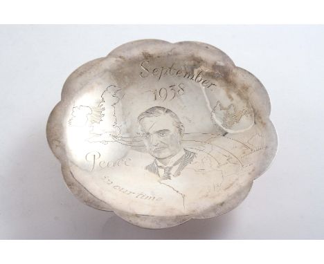
A SMALL HISTORICAL POLYFOIL DISH on compressed circular pot, engraved with the portrait of Neville Chamberlain and a map of Western Europe & Great Britain, made to commemorate the events of September 1938 (Chamberlain & Hitler's agreement) and Chamberlain's "Peace in our Time" address, by R. E. Stone, with facsimile signature & Sponsor's mark of Asprey & Co.Ltd., London 1938; 4.9" (12.5 cms) diameter; 3.7 oz

Lot 776

QTY OF BOSCASTLE MANOR ESTATES MAP/PLANS

Lot 75

WW1 'EDISWAN' OFFICERS MAP TORCH, 1917, SERIAL NUMBER 164166

Lot 450

A watercolour study entitled 'Black Backs And Terns' together with a coloured map of Suffolk

Loading...Loading...
  • 109182 item(s)
    /page

Recently Viewed Lots