We found 109182 price guide item(s) matching your search

Refine your search

Year

Filter by Price Range
  • List
  • Grid
  • 109182 item(s)
    /page

Lot 796

Original Robert Morden Hand Coloured Engraving Map of Gloucestershire

Lot 160

A Western National Omnibus Company Limited "Route Map of S. Devon & E. Cornwall Area" printed by Wheaton of Exeter, 28 3/4 x 20".

Lot 619

An early 20th Century wall hanging Ordnance Survey map of Sevenoaks and the surrounding area, 1910 edition, backed on linen.

Lot 300

A mid-19th century Craven & Co Directory Map of Bedfordshire, an early 19th century hand coloured map of Bedfordshire after Roper, another Bedfordshire map and one other item relating to John Bunyon's, Bedfordshire.

Lot 321

A small mixed lot of framed and glazed maps, including: a map of Buckinghamshire after Towley.

Lot 1111

A John Speede Map of Leicestershire circa 1610 - 1627, by Humble and Sudbury, 20 1/2'' x 15''

Lot 1217

A framed Map of the British Isles, including title Cartouche, compass rose, sailing ships and sea monster 19 1/2" x 15 1/2".

Lot 1218

A framed Print of a Street Map of Ross-on-Wye by Geoff Gwatkin, a framed Map of Hereford published by Pigot & Co. London, along with ''The Road from Bristol to Westchester'

Lot 1219

A large framed Map of the County of Hereford from an actual survey made in the year 1831, published by Greenwood & Co., London, engraved by J & C Walker. 29'' x 24''

Lot 1220

A large and mounted Map of Herefordshire by Emmanuel Bowen geographer to His Majesty. 27 1/2'' x 20 3/4''

Lot 1221

A framed and mounted Map of Herefordshire divided into Hundreds, exhibiting it roads, rivers, parks etc., by John Carey Engraver 1801. 20 1/2'' x 24''

Lot 1222

A framed and mounted Map of Gloucestershire in the scale of Myles with the Royal Coat of Arms for the Monarch of United Kingdom. Dieu et Mon Droit (God and my right), 20 1/2'' x 15 1/2''

Lot 1223

A framed John Speede Map of Herefordshire described with the true plot of the City of Hereford with Armes of the Noble that have been instituted with that dignitye. 20'' x 15''

Lot 1224

A small Map of Hereford, Frugiferi Ac Ameni Herefordie, 12'' x 11 1/2''

Lot 1226

A double sided framed and mounted hand coloured Map of Hereford having oats of arms being held up by cherubs, one cartouche being empty, 21 1/2'' x 17''

Lot 1227

A framed and mounted hand coloured double sided Map of Gloucester 'Glocestria Dvcatvs Vulgo Gloucestershire'', complete with coats of arms in top left corner being held up with cherubs, two cartouches being empty, 20'' x 16 3/4''

Lot 1232

A Gall and Inglis Map and Guide to London, mounted on cloth.

Lot 1332

An early Map of Staffordshire by William Kip, 12'' x 15 1/2'' in an Oak frame.

Lot 1338

A framed, two sided Map of The Mediterranean from the 1940's, 21'' x 18 1/2''.

Lot 391

Unknown - A circa 1945 cigarette cased with lighter, decorated with a silvered map titled 'Brit Zone' showing part of post war Germany controlled by the British over a marbled black and blue enamel ground, unmarked.

Lot 104

A good quality map of Cheshire mounted and framed under glass image size 20cm x 26cm, an aerial photograph of Halton including the Runcorn / Widnes bridge, an Ordnance Survey map of Runcorn and one other (4)

Lot 1652

An 1818 map of Linlithgow from actual survey by William Forrest

Lot 1327

An 1829 folding map 'New map of England and Wales' drawn from latest surveys, London, I Bumpus

Lot 439

A mixed lot of books including Observer's, Mrs Beeton, 1930's AA handbook, 1966 Police Procedure, A Geographia Contour Road Map etc

Lot 78

An 18th Century Coloured Map of Surrey, the road from London to Chichester, 19 x 12 cms

Lot 89

A Hand Coloured Map of Hampshire by H. Moll, together with four coloured engravings of the Isle of Wight and a continental school oil on board 'River Scene'

Lot 411

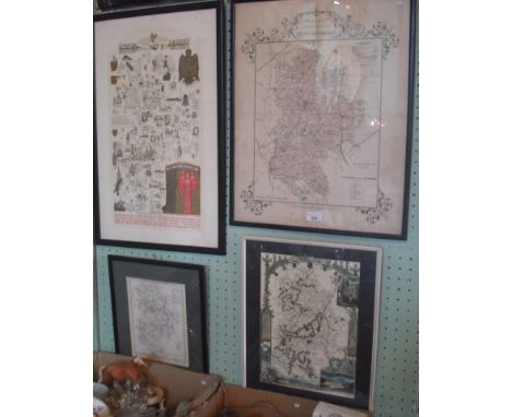
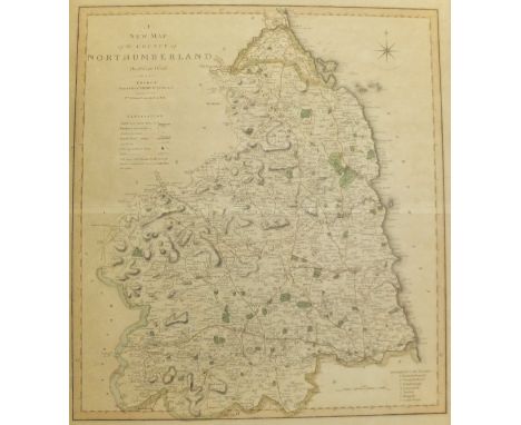
WILLIAM KIPP AFTER GEORGE OWEN "Penbrok Comitatus Olim Pars Demetarvm", a map of Pembrokeshire, black and white engraved map, later coloured, together with a further modern framed map of Northumberland CONDITION REPORTS Various crease marks all over. Unsure if stuck down. Is written in pencil on the bottom. Has various foxing, discolouration. Can see print through the back. Map of Northumberland is stuck down, discoloured and foxed and has crease to the centre, various scratches and marks all over, frame is chipped and has losses. Both with general wear and tear.

Lot 380

SINIA DE BENEDICTUS "Head and shoulder study of a young boy", oil, a folio containing a collection of various still life studies, etc, and various framed prints to include one of Great Yarmouth, a map of Norfolk, etc

Lot 361

A box of various pictures and prints, to include five framed fashion prints, framed map, six various framed botanical coloured plates, etc

Lot 276

A 19th Century map of Canaan The map fragment with text "Canaan, drawn, printed and coloured, Richard Lewis, Mr Rushbys, Farn Hill School, Nr Chester, May 1858", 63x50cms, together with a printed map of North Wales, 34x45cms.

Lot 102

A Model stationary engine, blue and white meat plates, old stoneware bottles, boxed nursery tea set, wall hanging map, vintage doll , Edwardian 2 handled tray , reproduction map and assorted pictures.

Lot 257

A Boxed " Hewlett Packard" financial calculator, an ivory handled cane and an un framed map " Cheshire Hunt". (3)

Lot 268

A Framed map " Plan of the city and suburbs of Worcester ".

Lot 482

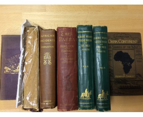
Books - Africa - travel. BAKER (S.W.) The Albert N'Yanza Great Basin of the Nile, two vols., 1866, 8vo, plates, two maps (one folding), original cloth, signs of use; MOUNTENEY- JEPHSON (A.J.) Emin Pasha, 1890, folding map and plates, worn cloth; WALLER (H) The last Journals of David Livingstone, 1874, two vols., folding map, vol. II damaged; THRUSTON (Major A.B.) African Incidents, 1900; one other (7)

Lot 891

Books, two boxes including some odd leather bound, Stanford's Road and Railway Map of England and Wales 1874 folding hand coloured map in cloth case, various other books

Lot 459

A John Speed map of Huntington, framed in a fire screen

Lot 559

Continental school, 19th century, bust portrait of a lady, pencil and watercolour, oval, 16 x 12 cm, a Robert Morden map of Hertfordshire, and three other pictures (5)

Lot 589

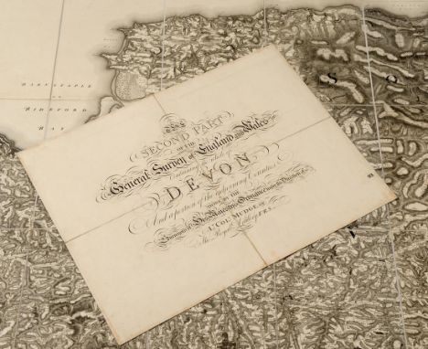
The Second Part of the General Survey of England and Wales Containing the Whole of Devon and a portion of the adjoining Counties Done By The Surveyors of His Majesty's Ordnance under the Direction of Lt Col Mudge of The Royal Artillery, FRS, linen backed, the map in two halves, each 123 x 184 cm, with a separate linen backed title sheet, 47 x 61 cm, contained in a contemp. calf book box with gilt crest of the Ordnance Board to the front panel See illustration

Lot 2579

John Speed, 'Stafford Countie and Towne, with the ancient Citie Lichfield described', map etching, by John Sudbury and George Humble, circa 1620, 36cm high, 49cm wide, framed and glazed

Lot 3029

An unusual printing 'Robin Hood and Little John' a first edition printed and published by William and Webster, White Hart St, Mansfield (Sherwood Forest), possibly late 19th Century early 20th Century together with a 1902, edition of Alice in Wonderland with 48 coloured plates by Margaret W Tarrant, an Edwardian edition, horses, dogs, birds, cattle (Ellimans); an 1880 edition of Mrs Beetons Household Management etc, and an old Motoring Map and a barley twist hall table (14)

Lot 3123

'The Perrier Map' motor map of England and Wales

Lot 4170

A Stamford wall hanging fabric map of 'Fox Hunting of Great Britain' published for 'The Field' showing which hunts cover with areas, with a bound book of the field, Feb-April 1932 (2)

Lot 1026

Postcards, Military, mixed selection including A.S.C 1916 (RP), Naval Camp at Blandford, (RP), Camp at Wool (RP), Church Parade Bovington (RP), Officer's Funeral 1916, German Retreat Soignies, 1918, Map card etc (one poor, rest gen gd)

Lot 1089

Postcards, a remaindered collection of Tuck Oilette cards from Germany (part-sets), modern map cards, WW1 Military maps, approx 200 cards mostly published by JWS, Queens Dolls House sets 4500-4505, in original packets, also some printed ephemera, Liebig cards, Canadian photo's (Cobalt, Ontario), souvenir silk handkerchief (Belgium) and also a few bookmarks and Victorian Greetings (mixed condition)

Lot 1160

Postcards/photos/ephemera, P Jones Collection, an interesting range of Novelty ephemera including map card, bookmark postcard, hold to the light, embossed 'in memoriam' cards, stereo cards, folded trade cards, midget cards, (Bairnsfather), giant cards, embroidered silk, appliqué, scraps and cut-outs, fantasy heads (skulls etc) (mainly vg) (60+)

Lot 794

Railwayana, a double sided Great Western Railway Map, produced by George Philip & Son, London, one side showing the full company region, the other side showing individual districts, 63cm x 49cm, (one side of glass cracked)

Lot 945

Postcards, a mixed Foreign selection of approx 600 cards including Ceylon, North Africa, Sudan, USA, Canada, Japan, Eastern Europe, Holland, SE Asia etc also topless, ships, ethnic, street scenes, Latvia map, stations etc (mixed condition)

Lot 562

WW2 1942 Philips War Map of The Far East, colour, opens out, good condition, cpl faults in selvedge

Lot 76

A folder of assorted postcards, together with a framed map of Devonshire and a small group of rice paper Chinese tortures

Lot 99

A Bartholomew New Plan of West London folding linen backed map, circa 1900, partially coloured, signs of use; Legion of Frontiersmen, three note books of hand written  lecture notes dated circa 1916, with illustrations; and an East Cheshire Squadron handbook with general orders

Lot 476

A coloured map of Hertfordshire, framed to show pages from a book to the reverse

Lot 475

A Robert Modern hand coloured engraved map of Essex, framed

Lot 1

18TH CENTURY ANTIQUARIAN SURVEY MAP OF CANDLEWICK WARD NO. 41 (ACT OF PARLIAMENT 1754 FOR STOWS SURVEY) 37CM X 30CM APPROX F/G

Lot 112

ANTIQUARIAN MAP ENGRAVING OF NORTH WALES ENGRAVED FOR WALPOOLES NEW COMPLETE BRITISH TRAVELLER F/G 35.5CM X 23CM APPROXIMATELY

Lot 3

TWO 19TH CENTURY ANTIQUARIAN MAP PRINTS OF WARWICKSHIRE BY MOULE 20CM X 26CM APPROX F/G AND DERBYSHIRE CIRCA 1848 B MOULE 19CM X 26CM APPROX F/G

Lot 5

THREE 19TH CENTURY ANTIQUARIAN MAP PRINTS BY MOULE OF BUCKINGHAMSHIRE 20CM X 26CM APPROX F/G, DURHAM CIRCA 1840 26CM X 20CM F/G AND ONE OTHER OF DURHAM CIRCA 1835 IN MOUNT 27CM X 20CM APPROX

Lot 1017

SEVEN VARIOUS FRAMED PICTURES, including a map of Derbyshire

Lot 240

A LARGE BOX CONTAINING A QUANTITY OF WWII ERA MILITARIA, to include helmets, water bottles, German gas mask and case, SMLE, magazine, belts, webbing, kitbags etc, also silk escape map No.4 MKII spike bayonet

Loading...Loading...
  • 109182 item(s)
    /page

Recently Viewed Lots