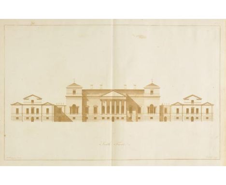

Brettingham (Matthew). The Plans, Elevations and Sections, of Holkham in Norfolk, the Seat of the Late Earl of Leicester, 1st ed., 1761, 23 sepia-engraved plates and plans only (of 28), lacking dedication and preface leaves, folding plate with small marginal loss and reinforcements, some scattered spotting, near contemporary half sheep, rubbed, folio, (Harris 46. Provenance: The Earl of Leicester, presentation inscription (and later inscription) to title),together with Ainsworth (William), Researches in Assyria, Babylonia, and Chaldaea; Forming Part of the Labours of the Euphrates Expedition, 1st ed., 1838, tinted lithographed frontispiece (with blindstamp), title with wood-engraved vignette, folding map, three hand-coloured folding geological sections at end, publisher's catalogue, scattered light spotting, endpapers renewed, original green blindstamped cloth, spine darkened and re-adhered with old shelf numbers, small splits and chips, 8vo, plus Macdonald (Capt. R.J.), The History of the Dress of the Royal Regiment of Artillery, 1625-1897, Sotheran, 1899,25 colour plates, scattered light spotting, original cloth-backed boards, edges a little rubbed, a few light marks, 4to Limited edition, 67/300 signed by the author. (3)
We found 108737 price guide item(s) matching your search
There are 108737 lots that match your search criteria. Subscribe now to get instant access to the full price guide service.
Click here to subscribe- List
- Grid
-
108737 item(s)/page
Cary (John). Cary's Survey of the High Roads from London to Hampton Court, Ware, Bagshot..., Richmond, On a Scale of one Inch to a Mile; wherein Every Gentleman's Seat, situate on, or seen from the Road, (however distant) are laid down, with the name of the Possessor; to which is added, the Number of Inns on each separte Route; also, The different Turnpike Gates shewing the Connection which one trust has with another, 1st edition, 1st July, 1790, title page and table of explanation, folding engraved general map of the environs of London showing the turnpike roads with sparse contemporary outline colouring, another map showing the turnpike gates with contemporary wash colour and eighty double page engraved strip road maps (complete) on forty sheets, all with contemporary hand colouring, some staining throughout, contemporary sheep 'envelope style' binding, worn and frayed, 8vo (1)
Cooke (William). A New Picture of the Isle of Wight, Illustrated..., to which is prefixed, an Introductory Account of the Island, and a Voyage Round its Coast, 1808, Extra Illustrated containing engraved frontispiece and fifty-four engraved & uncoloured aquatint plates (36 plates called for), hand-coloured engraved map, plus five others loosely inserted, occasional spotting, contemporary calf gilt, upper joint and spine torn at head, rubbed, 4to, together with Britton (J., & Brayley, E.W.), Devonshire & Cornwall Illustrated, from the Original Drawings by Thomas Allom, WH. Bartlett..., with Historical and Topographical Descriptions, 1832, two engraved maps and two engraved titles, 138 engraved views on 69 plates, some spotting, all edges gilt, contemporary half morocco, covers detached and spine torn with loss, worn, 4to, plus two other Isle of Wight related (4)

Coxe (William). An Historical Tour in Monmouthshire; Illustrated with Views by Sir R. C. Hoare, Bart. A New Map of the County, and Other Engravings, 2 vols., 1st ed., Printed for T. Cadell, Jun. and W. Davies, 1801, half-titles present, Extra Illustrated containing a total of 221 plates, plans & maps, mostly 18th/19th century (some window mounted), comprising 10 maps (3 folding) including the Countye of Monmouth by John Speed [1627], County of Monmouth by Robert Morden [1695] and Monmouthshire by N. Coltman, one pencil drawing, 17 double-page & two folding plates & plans, numerous engraved illustrations to text, occasional spotting, top edge gilt, cloth hinge repairs, later 19th century panelled calf, gilt decoration, contrasting morocco labels to spines, neatly rebacked, 4to Upcott, pp.933-939. (2)
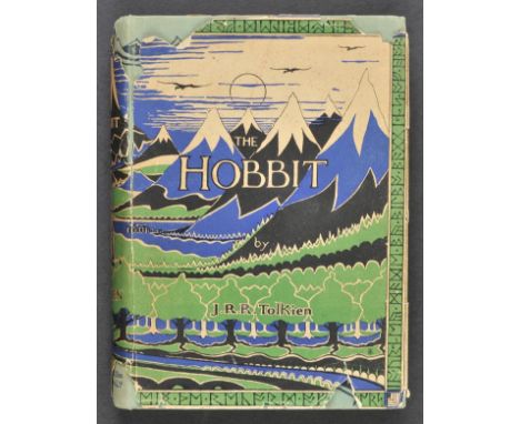
Tolkien (J.R.R.). The Hobbit or There and Back Again, 1st ed., 2nd impression, 1937, four colour plates by the author, black and white illustrations, advertisement leaf at end, map endpapers, neat presentation inscription to front endpaper, original green pictorial cloth, small lightly faded patch at foot of spine, d.j., vertical split along upper joint (just attaching), some chips and losses, spine and flaps a little toned, 8vo The second impression, published in the same year as the first and is the first edition with the colour plates. (1)
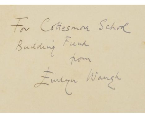
Waugh (Evelyn). When the Going Was Good, 1st ed., 1946, colour frontispiece, folding map, light spotting front and rear, original yellow cloth, price-clipped d.j. (spine ends and folds strengthened with white tape to verso), 8vo Presentation copy, inscribed to front endpaper: "For Cottesmore School Building Fund, from Evelyn Waugh". (1)
Waugh (Evelyn). Labels. A Mediterranean Journal, 1st ed., 1930, half-tone illustrations, one or two spots, original cloth, spine faded, d.j. tears and losses, mainly to spine, 8vo, together with When the Going Was Good, 1st ed., 1946, colour frontispiece, folding map, original yellow cloth, d.j., a few chips and tears to spine and front panel, 8vo, plus A Tourist in Africa, 1st ed., 1960, illustrations, original cloth, d.j., spine and rear panel a little toned, 8vo, with three others: Remote People, 1931, Waugh in Abyssinia, 1936, and Wine in Peace and War [1947], all lacking d.j.s (6)
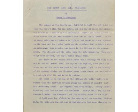
*Williamson (Henry, 1895-1977 ). The Fight with Orca Gladiator, unpublished typescript short story, circa 1930s, 18 leaves of single-sided cyclostyled typewritten text, tear with some text loss to left margin of page 4, final leaf chipped and frayed without loss of text but with some toning and lightening of two lines of text, two small manuscript corrections (? by Williamson) to last page, 4to, together with On Foot in Devon or Guidance and Gossip, Being a Monologue in Two Reels, 1st edition, 1933, 8 photographic plates, map endpapers, author's signed presentation inscription to front free endpaper, inscribed for Betty Radford and dated at Lydford, 18 September 1933, written on cloth in dust jacket, spine browned and split at foot of upper joint, 8vo The climax of this short story concerns a dramatic sea battle between a killer whale and four sea lions named Princess, Berserk, Daggoo and Ra. (2)
Moule (Thomas). The English Counties Delineated; or a Topographical Description of England..., 2 volumes, published George Virtue, 1837, additional decorative title, portrait frontispiece of William IV, folding decorative engraved map of England & Wales, trimmed with slight loss, four sheet map of England & Wales, a 'comparison' plate, one engraved plate of Canterbury Cathedral and forty-nine decorative engraved maps, several trimmed with slight loss, slight spotting throughout, near contemporary half calf, re-backed but retaining original spines, marbled sidings a little rubbed, 4to, together with, Aikin (John), England Delineated; or a Geographical Description of every County in England and Wales..., 3rd edition, 1795, folding engraved map of England & Wales and forty-two uncoloured engraved county maps, occasional pencil annotations to text, some staining to rear of atlas affecting maps and text, modern half calf gilt, 8vo (3)
Pennant (Thomas). A Journey from London to the Isle of Wight, 2 vols. in one, 1801, hand-coloured engraved folding map frontispiece to each volume, 47 engraved plates (of 48, lacking plate of St. Augustin's Monastery, one plate folding), occasional minor spotting, dampstain to fore-edge margins, together with Some Account of London, 4th edition, 1805, additional engraved title, 15 engraved plates including 3 folding (of 16), one plate repaired to fore-edge margin, some dampstaining, offsetting & spotting, plus A Tour from Downing to Alston-Moor, 1801, half-title, 27 engraved plates, bound with A Tour from Alston-Moor to Harrowgate, and Brimham Crags, 1804, 9 engraved plates, some dampstaining mostly to margins, uniform contemporary tree calf, each volume neatly rebacked, Alston Moor volume with some staining at foot of boards, 4to Provenance: From the library of Frederick Morrell, Black Hall, St. Giles, Oxford, with his bookplate. (3)
Prout (John Skinner). The Castles and Abbeys of Monmouthshire, 1838, tinted lithograph title, lithograph dedication and 29 tinted lithograph plates, spotting throughout (particularly to title), contemporary red half morocco gilt, spine and extremities rubbed, damp mottling to lower board, large folio, (56.7 x 38cm), together with a folding engraved map of Gloucestershire by Saxton Kip [c.1637] with relevant text leaves from Camden's Britannia, repair to central fold with slight loss, few closed tears and fraying, engraved map of Monmouthshire by Pigot & Co. (hand-coloured in outline) Abbey Scenery 538. (1)
Skelton (Joseph). Engraved Illustrations of the Principal Antiquities of Oxfordshire from Original Drawings by F.Mackenzie, published J.Skelton, 1823, decorative calligraphic title, uncoloured engraved map, fifty uncoloured engraved plates, numerous engraved chapter headings, some spotting throughout, near contemporary half morocco gilt, rubbed and worn at extremities, large 4to, together with, Westall (William), Great Britain Illustrated, A Series of Original Views, published Charles Tilt, 1830, additional decorative title, 118 uncoloured engraved views on fifty-nine sheets, some spotting throughout, contemporary gilt decorated calf, upper board detached, worn and frayed, 4to, with, Allom (Thomas, Noble T. & Rose T.), The Counties of Chester, Derby, Leicester, Lincoln and Rutland, published Fisher Son & Co., circa 1850, additional decorative title with contemporary dated ownership signature, seventy-two engraved plates on thirty-six sheets, slight spotting, a.e.g., publisher's cloth gilt, spine near detached and partially lacking, worn and frayed, 4to, plus, Jaffray (James), Graphic Illustrations of Warwickshire, published Birmingham, 1862, thirty-two uncoloured engraved plates, very slight spotting, a.e.g., contemporary half morocco gilt, worn at extremities, 4to, and Dugdale (William), Curiosities of Great Britain. England & Wales Delineated..., 3 volumes, published J.Tallis, circa 1845, decorative title, engraved frontispiece to each volume, a few of the front leaves detached, 225 engraved topographical views, eighteen portraits and fifty-eight double page engraved maps, some offsetting to maps, slight spotting thoughout, hinges and joints weak, contemporary marbled calf, gilt decorated spines, spine on volume two split, spines faded, worn, 8vo (7)
Abbot (Charles). Flora Bedfordiensis, Comprehending such Plants as Grow Wild in the County of Bedford, According to the System of Linnaeus with Occasional Remarks..., published Bedford by W.Smith, 1798, title page with author's manuscript presentation inscription, six uncoloured engraved plates, indexes bound at rear, ownership signature to front endpaper, 19th-century half calf gilt, a little bumped, 8vo, together with Druce (George Claridge), The Flora of Berkshire... , Oxford, 1897, later inscription to front endpaper, The Flora of Buckinghamshire... , 1926, black and white frontispiece, both original cloth, boards slightly marked, spines lightly rubbed to head and foot, 8vo, (2 volumes in total), plus Mansel-Pleydell (John Clavell), The Flora of Dorsetshire..., 2nd edition, 1895, 1 colour folding map frontispiece, 1 colour folding map to p. 1, 1 extra colour folding map disbound to rear, some light spotting, contemporary inscription to front endpaper, original gilt-decorated red cloth, boards and spine slightly marked, 8vo, and Jones (J.P. & Kingston, J.F.), Flora Devoniensis..., 1829, contemporary inscription to half-title, worming to top right corners from front pastedown to p. 16 of 'Part II. Arrangement of The Plants According to the Natural Method', some light spotting, contemporary half calf boards and spine rubbed, hinges cracked, 8vo, plus other county flora reference, generally in good condition, 8vo/4to (approx. 70)
Burton (Richard F.). The Lake Regions of Central Africa. A Picture of Exploration, 2 vols., 1st ed., 1860, twelve chromoxylographed plates, folding map, wood-engraved illustrations, advertisement leaf at end of volume 2, a few minor spots, bookplate and previous owner inscription to front pastedowns, original violet blindstamped cloth, rebacked with original spines relaid (faded), 8vo Penzer pp. 65-66. A classic work on East Africa, in which Burton describes his journey from Pemba and Zanzibar to the western shore of Lake Tanganyika. Amongst his party was John Hanning Speke who Burton attempts to discredit from the outset, by stating in the Preface that he was no more than a subordinate. (2)
Holt (John). General View of the Agriculture in the County of Lancaster: with Observations on the means of its Improvement. Drawn up for the Consideration of the Board of Agriculture and Internal Improvement from the Communications of Mr John Holt of Walton, near Liverpool; and the additional Remarks of several respectable Gentlemen and Farmers in the County, 1795, folding engraved county map, five engraved plates (one folding), two folding tables, and few wood engraved illustrations, bookplate of North of Thurland Castle, contemporary half calf, lower board detached and upper board loose & near detached, spine and extremities worn, 8vo, together with The Commercial and Agricultural Magazine, vols. 1-10, pub. 1799-1804, few engraved plates and maps (some folding), volume 1 title with short tear & printing fault to imprint, contemporary half calf, lacking title labels, worn with some leather lifting, marbled sidings torn with loss and some lifting or lacking, 8vo Sold with all faults, not subject to return. (11)
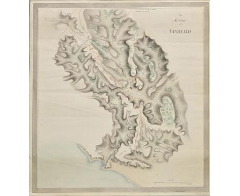
Battle plans. Smith (Malcolm), The Action of Vimiero, circa 1808, pen and watercolour manuscript battle plan of the battle of Vimeiro, occasional marginal closed tears, 540 x 510 mm The battle of Vimeiro was a resounding victory for General Arthur Wellesley (later the Duke of Wellington) against the French during the Peninsular war; fought in Portugal near Lisbon. Its significance was that it effectively ended the first French invasion of Portugal. Captain Malcolm Smith of the 83rd (County of Dublin) regiment whose signature appears lower right, appears to be the author of the map but it is an historical observation as his regiment did not arrive in Portugal until April 1809, some seven months after the battle. (1)
Bedfordshire. Speed (John), Bedford Shire and the Situation of Bedford described with the Armes of thos Honorable Familyes that have borne ye titles of Dukes and Earls thereof, published Roger Rea, [1662], uncoloured engraved map, inset plan of Bedford, small library blindstamp to margin, slight staining largely confined to margin, 380 x 510 mm, English text on verso (1)
![Berkshire. Speed (John), Barkshire Described, published Roger Rea, [1662], uncoloured engraved map, large engraved panorama o](https://cdn.globalauctionplatform.com/e6986aac-6ee6-4136-8dcf-a56700bd94e2/a4b737ca-6848-4e5c-dd25-00ff176b6397/468x382.jpg)

Bohemia. Speed (John), Bohemia Newly Described, published George Humble, circa 1627, uncoloured engraved 'carte a figures' map, ten costumed figures to vertical margins and seven oval vignettes along upper horizontal margins, lower margin trimmed to neatline with slight fraying, 410 x 525 mm, English text on verso (1)
*Cheshire. Blome (Richard), The County Palatine of Chester with its Hundreds, circa 1673, hand coloured engraved map, 260 x 320 mm, framed and glazed, together with, Simmons (Matthew), Cheshire, circa 1643, hand coloured minature engraved map shown below a triangular mileage table, engraved by Jacob Van Langeren, 110 x 110 mm, mounted, framed and glazed, with, Ramble (Reuben), Cheshire, circa 1845, engraved map with contemporary colouring, with coloured lithographic vignettes to the borders, overall size 190 x 150 mm, mounted, framed and glazed, plus, Moll (Herman), The County Palatine of Chester, circa 1724, hand coloured engraved map, the vertical margins decorated with uncoloured engravings of antiquities, 200 x 320 mm, framed and glazed, and, Kitchin (Thomas & Jeffreys Thomas), A Map of Cheshire, circa 1749, engraved map with contemporary hand colouring, 190 x 145 mm, mounted, framed and glazed (5)
China. Russell (J.), China Divided into Provinces Drawn from the best Authorities, published C.Dilly and G.G. & J.Robinson, 1799, engraved map with contemporary outline colouring, slight offsetting, 405 x 460 mm, together with, Rollos (George), An Accurate Map of the Empire of China, circa 1770, uncoloured engraved map, 265 x 335 mm, with, Rapkin (J.), China and Burmah, published J & F Tallis, circa 1850, engraved map with contemporary outline colouring, 265 x 340 mm, with four other similar maps, together with approximately 130 engraved illustrations set in text relating to China, originally published in The Illustrated London News and The Graphic, each sheet 380 x 260 mm, plus two aquatints with contemporary hand colouring published by W.Miller of Chinese topographical views, each approximately 220 x 260 mm, plus a 20th century watercolour of junks at anchor, signed 'Ling' 345 x 515 mm, with original receipt (dated 1952), and a Chinese newspaper and a late 18th century uncoloured engraving of a Chinese fishing cormorant by W.Skelton, 305 x 360 mm, mounted (approx 140)
![Cornwall. Speed (John), Cornwall, published Roger Rea, [1662], uncoloured engraved map, inset view of Launceston, slight fray](https://cdn.globalauctionplatform.com/e6986aac-6ee6-4136-8dcf-a56700bd94e2/f8172de9-fe42-45e5-bc5c-0f5b1ee039db/468x382.jpg)
Cornwall. Speed (John), Cornwall, published Roger Rea, [1662], uncoloured engraved map, inset view of Launceston, slight fraying to margins not affecting image, small library blindstamp to margin, central fold partially split and strengthened on verso, slight staining, slight creasing, 385 x 510 mm, English text on verso (1)
*Derbyshire. Saxton (Christopher & Hole William), Universi Derbiensis Comitatus qui olim Coritanorum suit Descriptio, circa 1610, hand coloured engraved map, large strapwork cartouche and compass rose, slight creasing, 285 x 310 mm, mounted, framed and glazed, together with, Saxton (Christopher & Hole William), Staffordiae Comitatus pars olim Cornauiorum, [1637], hand coloured engraved map, 275 x 375 mm, mounted, framed and glazed, with, Moll (Herman), Staffordshire, [1724 or later], hand coloured engraved map, horizontal borders decorated with antiquities, 315 x 185 mm, mounted, framed and glazed (3)

Essex. Speed (John), Essex devided into Hundreds with the most Antient and fayre Towne Colchester Described and other Memorable Monuments Observed, published Roger Rea, [1662], uncoloured engraved map, inset town plan of Colchester, repaired marginal closed tears, small library blindstamp to margin, 385 x 510 mm, English text on verso (1)


Europe. Speed (John), A New Mappe of the Romane Empire, published George Humble, circa 1627, uncoloured engraved 'carte a figures' map, ten costumed figures to vertical margins and six oval vignettes of principal cities to upper horizontal margin, partial split to central fold, strengthened on verso, 395 x 505 mm, English text on verso (1)


86 Zatta, Antonio. Atlante novissimo, illustrato ed accresciuto sulle osservazioni, e scoperte fatte dai più celebri e più recenti geografi. Venezia, Antonio Zatta, 1775-85. In 2° (385 x 282 mm); XVI, 50, [8]; [2]; [2]; [2] pagine. Antiporta a doppia pagina disegnata da Novelli ed incisa da Zuliani con la personificazione della Serenissima in trono, 4 frontespizi con il titolo entro bordura incisa in rame, grande testata alle armi di Carlo Spinola dedicatario dell’opera, 219 tavole calcografiche a doppia con vivida coloritura coeva (pochi piccoli difetti, sporadiche arrossature sulla piega di alcune carte.) Legatura coeva in mezza pergamena con angoli, titolo manoscritto al dorso, tagli rossi (sciupata, qualche mancanza). Tassello e scheda della libreria Bourlot di Torino. Splendido esemplare della prima edizione, uno dei più affascinanti ed esaustivi atlanti prodotti nel Settecento veneziano, con le sue belle carte geografiche disegnate prevalentemente da Giovanni Pitteri e incise da Zuliani, comprese le 12 carte delle Colonie Unite dell’America Settentrionale di John Mitchell, e le 3 carte con le Nuove scoperte de’ Russi, Nuove scoperte nel Mare del Sud e la Nuova Zelanda. Cremonini pagg. 117-119; Phillips, Atlases, 650. (4 volumi) € 8.000,00 ERRATA CORRIGE LA CARTA GEOGRAFICA DEL CHILE è RESTAURATA - MAP OF CHILE RESTORED


George MontgomeryChart of Lough Erne and Donegal Bay This is a navigational chart in three separate sheets mounted on cloth, The title is in the upper centre, unframed, and reads “A Chart of Lough Erne and Donegal Bay, in the Counties of Cavan, Fermanagh and Donegal, with a Map of the adjacent country, delineated from a trigonometrical survey A.D. MDCCCXVIII, by G. Montgomery & Sons. Residence Lifford, Posttown Strabane. Neele & Son sculp. 35 Strand, London. Published as the Act directs March 20th 1821 by Edwd. Duffy, Enniskillen.”There are large headings for Scales and Explanation, but no insets. 2,190 x 790mm.
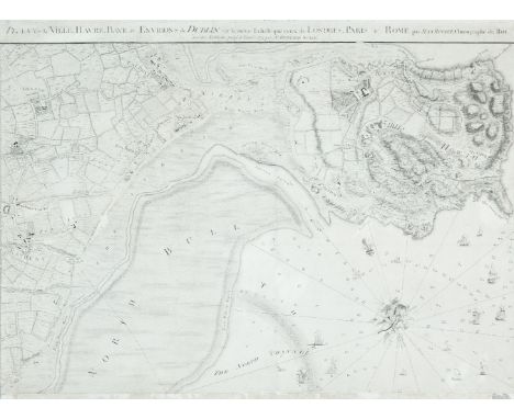
John Rocque (1705-1762)Chart of Dublin Bay and Plan of Dublin and Environs This is on four sheets, the bottom left sheet of which can be regarded as a town-plan of Dublin and the remainder as a map of the surroundings and a chart of Dublin Bay. The town-plan is a later state of No. 2 described in the Introduction, with the addition of river depths and the outer administrative boundary of the city.It shows the coast from Scotchman's Bay, Dalkey, northwards to include all of Howth Head, and inland to the centre of Phoenix Park and Finglas. The title is printed above the top of the two northern sheets and reads A Survey of the City Harbour Bay and Environs of Dublin on the same scale as those of London Paris & Rome By John Rocque Chorographer to his Royal Highness the Prince of Wales. Plan de la Ville, Havre, Baye & Environs de Dublin sur la meme Echelle que ceux de Londres, Paris & Rome par Jean Rocque chorographer du Roi avec des additions jusq a l'année 1773 par Mr Bernard Scalé. In the top left, in an irregular frame with the royal arms, is the dedication To His Royal Highness Prince Edward This Plan is most humbly inscribed by His Most Obedient Humble Servt. John Rocque. Below the left half of the frame are four scales: A Scale of an Irish Mile 320 Perches [= 168 mm.] A Scale of Yards 1000 [= 83 mm.] Echelle de Toises 500 [= 93 mm.] A Scale of an English Mile 320 Perches [= 132 mm.]. Alongside the scales is Published according to Act of Parliament and J.J. Perret Sculpt. Below the right half of the frame is an Explanation of the many symbols of boundaries and types of land use on the map. The bay has an indication of sand-banks and coastline with many soundings and 75 ships extending up the river Liffey. There is a decorative compass indicator of fish, nets and cornucopia showing true and magnetic north to the top left.There are three insets in the top left corner:1. Kildare House (120 x 210 mm.) showing the house and frontage on to Kildare Street, with various types of carriages arriving.2. The Barracks (120 x 208 mm.) with ladies and gentlemen strolling in front.3. The Royal Hospital (105 x 133 mm.) at Kilmainham, viewed from across the river.There is also an inset in the bay (195 x 197 mm.), depicted as if on a sheet, showing Dublin Anno 1610 Dublin comme il etait en 1610. The plan is flanked by two notes The Figures of the surroundings are Dotted thus . to distinguish them from those of the References. this Plan is Copyed from that Taken in 1610 and the Spelling the Same as at that Time. There are 69 numbers and a key for streets and buildings. Four sheets when joined. 1,395 x 1,010 mm. (4) For a full description see Abl Printed maps of Dublin R2. 1-4

Ralph William Seale 1732-1775The Irish Sea This occurs in The Universal Magazine of 1757 (Vol. 21, opposite p. 49.)The title in the lower left corner in an ornate scalloped frame, reads A New and Accurate Map of the Parts of England, Scotland & Ireland, Bordering on St. George`s Channel, &c. Below the frame is Univers. Mag. J. Hinton, Newgate Street and below the right corner of the frame is R.W. Seale del. et sculp. 265 x 365 mm.
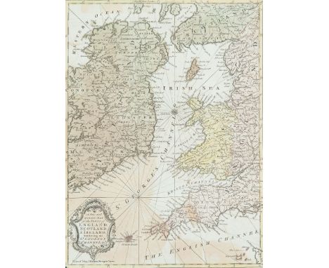
Ralph William Seale 1732-1775 II The Irish Sea This occurs in The Universal Magazine of 1757 (Vol. 21, opposite p. 49.)It shows a similar area to the previous chart except that it omits the west coast of Ireland. There are fewer markings round the coast, but there are again the rhumb lines, without soundings. The title in the lower left corner in an ornate scalloped frame, reads A New and Accurate Map of the Parts of England, Scotland & Ireland, Bordering on St. George`s Channel, &c. Below the frame is Univers. Mag. J. Hinton, Newgate Street and below the right corner of the frame is R.W. Seale del. et sculp. There is no scale of length, but latitude and longitude west from London are marked along all four sides, and there is one compass rose. 265 x 365 mm.
![Thomaso Porcacchi (1530-1585)A Map of IrelandFrom his L'Isole Pio Famose de Mondo [1572] published in Venice in 1572. 150 x](https://cdn.globalauctionplatform.com/e735d6ad-4cf0-4f70-b2a0-a56400ca6cae/bddd7b64-f35a-47f3-8535-ad0fa9156248/468x382.jpg)


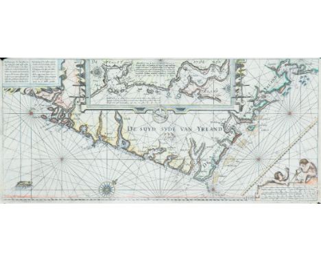
Janssonius, Johannes (1588-1664)Bookseller and publisher, produced his version of Blaeu`s Het Licht der Zeevaert in 1620. He also, with others, produced the Atlas Novus in 1650, in many languages, the fifth volume of which contains his chart of Ireland and the Irish Sea.A Chart of the South-east Coast of Ireland (1650)“Beschrijvinge der Zeecusten vande Suijd-sijde van Ierlant …..” and “Description des costes marines meridionales et Orientales d`Irlande ….”; long title in Dutch and French for this chart based on Blaeu`s chart of south-east Ireland. There is a large meridian bar above the scales and map number “16” in the lower right corner. From Het Licht der Zeevaert (1620). Verso blank. 540 x 250.
-
108737 item(s)/page