

British Isles. De Fer (Nicolas), Les Isles Britanniques ou se Trouvent Les Royaumes D'Angleterre, D'Ecosse et D'Irlande, Paris, 1706, hand-coloured engraved map, large decorative cartouche, slight dust soiling, 460 x 485 mm, together with Cassini (Giovanni Maria). le Isole Britanniche O Seino Li Tegni di Inghilterra, Scozia ed Irlanda..., Rome, 1796, engraved map with contemporary outline colouring, inset map of the Shetland Islands, 495 x 355 mm, with Duval (Pierre). Carte des Isles Britaniques où sont les Royaumes d'Angleterre et d'Escosse que nous appellons Grande Bretagne et celui d'Irlande..., Paris, 1665, engraved map with contemporary outline colouring, large margins, 475 x 350 mm, plus De Wit (Frederick). Nova Totius Angliae, Scotiae et Hiberniae.., circa 1675, engraved map with contemporary outline colouring, 485 x 570 mm, and De Lisle (Guillaume). Cartes des Isles Britanniques..., Paris, circa 1710, uncoloured engraved map, old folds, some creasing, 405 x 360 mm, with, Von Euler (Leonhard). Tabula Geograph. Magne Britanniae, engraved map with contemporary outline colouring, small ink collector's stamp to the lower left corner, some water staining, 310 x 365 mmQTY: (6)
We found 109182 price guide item(s) matching your search
There are 109182 lots that match your search criteria. Subscribe now to get instant access to the full price guide service.
Click here to subscribe- List
- Grid
-
109182 item(s)/page
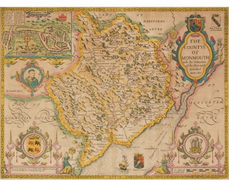
* Monmouth. Speed (John). The Countye of Monmouth with the situation of the Shire-towne Described, Thomas Bassett & Richard Chiswell [1676], hand-coloured engraved map, inset town plan of Monmouth, very slight text show through, 385 x 510 mm, mounted, framed and glazed, together with Blaeu (Johannes). Monumethensis comitatus vernacule, Monmouth Shire, Amsterdam, circa 1645, engraved map with bright contemporary hand colouring, elaborate cartouche and mileage scale, 380 x 495 mm, mounted, framed and glazedQTY: (2)
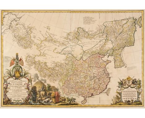
China. D'Anville (Jean Baptiste Bourguignon), Carte la plus Generale et qui Comprend La Chine, La Tartarie Chinoise et le Tibet Dressée sur leas cartes Particulieres des RR PP Jesuites, Paris, 1734 - [37], large engraved map with contemporary outline colouring and some later enhancement, large decorative cartouche and mileage scale, good margins, 495 x 705 mmQTY: (1)NOTE:The Qing Emperor Kangxi commissioned Jesuit surveyors to chart his kingdom from 1708 to 1716. The resulting maps were published as the Kangxi Atlas (1718-19), and the information contained in its woodcut maps would not be superseded for well over a century.The French cartographer Jean-Baptiste Bourguignon D'Anville (1697-1782), acquired copies of the Kangxi maps and devised his own interpretations, first printed in Jean-Baptiste Du Halde's "Description Geographique historique...de l'Empire de la Chine et de la Tartarie Chinoise". The cartouche reflects this connection, showing Emperor Kangxi seated above the strapwork borders of the title, presiding over the surveying parties, where two Jesuit priests, with an armed mounted escort, are investigating a settlement, with its houses, sheep and cattle.
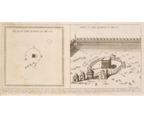
Sale (George, translator). The Koran, Commonly called the Alcoran of Mohammed, Translated into English immediately from the Original Arabic; with explanatory notes, taken from the most approved commentators. To which is prefixed a Preliminary Discourse, 1st edition in English, London: C. Ackers for J. Wilcox, 1734, title printed in red and black, folding engraved map of Arabia by R.W. Seale (small reinforcement to verso), 3 genealogical tables (2 folding), folding engraved plan and view of Mecca, water stain throughout, small bookplate of William Vickers jun. all edges red, later blindstamped calf gilt, sympathetically rebacked with red label, a little rubbed with small wormtrack at head of upper cover, 4toQTY: (1)NOTE:ESTC T146975; Rothschild 1811. The first edition in English directly translated from the Arabic. There was a 1649 translation in English by Alexander Ross but this was taken from the poor French translation by André du Ryer in 1647.
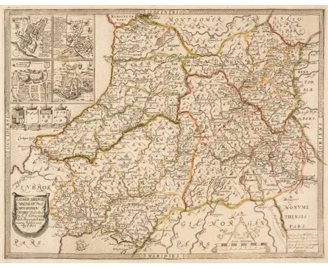
Wales. Saxton (Christopher & Lea Philip), Radnor, Breknoke, Cardigan and Carmarthen, Discribed by C. S. Corrected and Amended with many Additions by P. Lea, circa 1693, engraved map with contemporary outline colouring, inset town plans of Carmarthen, Brecknock, Radnor and Cardigan, mount stained, 365 x 465 mm, together with Kitchin (Thomas). An Accurate Map of Carmarthenshire drawn from an actual survey..., [and] An Accurate Map of Glamorganshire drawn from an actual survey..., J. Tinney 1754, two engraved maps on one sheet (as published), both with contemporary outline colouring, slight spotting, overall size 705 x 540 mm, with An Accurate Map of Cardiganshire drawn from an actual survey..., [and] An Accurate Map of Pembroke Shire drawn from an actual survey..., J. Tinney, 1754, two engraved maps on one sheet (as published), both with contemporary outline colouring, slight spotting, overall size 705 x 540 mm, plus Blaeu (Johannes). Monmethensis comitatus vernacule Monmouth Shire, Amsterdam, circa 1645, engraved map with contemporary outline colouring, decorative cartouche and mileage scale, slight dust soiling, 380 x 495 mm, French text on verso, and Cary (G. & J.). Untitled map (Sheet 16) of South Wales, 1832, engraved map with contemporary outline colouring, slight mount staining, 530 x 635 mmQTY: (5)
Thomson (John & Co.). A collection of nine maps, West India Islands, West Indies, Remote British Islands, Martinico & Dominica (on one sheet), Jamaica, Guadaloupe Mariegalante etc. & Antigua (on one sheet), Porto Rico and Virgin Islands & Haiti Hispaniola or St Domingo (on one sheet), Grenada Tobago Curacao & Trinidad (on one sheet), St Christophers St Lucia and Nevis (on one sheet) [and] St Vincent & Barbadoes (on one sheet), circa 1830, together nine engraved maps with contemporary outline colouring, each with an ink library stamp affecting the printed image, heavily stained, together with Speed (John). Midle-Sex described with the most Famous Cities of London and Westminster, Thomas Bassett & Richard Chiswell [1676], hand-coloured engraved map, inset town plans of Westminster and London and inset views of St. Peters and St. Pauls, dust-soiled and stained, central fold and upper margin worn and torn with slight loss, repaired, the whole backed with later thick paper, 385 x 515 mm, with Bowen (Emanuel). Dorset Shire Divided into its Hundreds..., Carington Bowles and Robert Sayer, circa 1762, engraved map with contemporary outline colouring and some later enhancement, originally published in "The Large English Atlas", 540 x 705 mm, framed and glazed, plus Klint (Gustaf). Charta Öfver Upgående Grunden jemte Öpningarne till Saint Georges, Bristols soch Engelska Canalerne, Stockholm, 1801, uncoloured engraved sea chart of Cornwall, Devon, The Scilly Isles, Southern Ireland and the Western Approaches, 650 x 950 mm plus another six maps, including examples by or after Rapkin, Pigot, Russell, W. & A. K. Johnston, J. & C. Walker and Cary, various sizes and conditionQTY: (18)
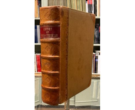
Williams (David). The History of Monmouthshire; illustrated and ornamented by views of its principal landscapes, ruins, and residences; by John Gardenor, Vicar of Battersea, engraved by Mr Gardenor and Mr Hill, London: printed by H. Baldwin, 1796, engraved map, 36 uncoloured aquatint plates, adhesive tape repairs to half title, to a few plates and leaves and at gutter and margins of plates, a few plates detached, map with frayed outer margin and repair to verso, some light spotting and stains, detaching front endpaper with previous owner inscriptions, later half calf, red label to spine, edges a little rubbed, 4toQTY: (1)NOTE:Abbey Scenery 537.
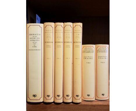
Richardson (Thomas Miles). Memorials of old Newcastle upon Tyne ... comprising forty etchings from original drawings of the towers, gateways, churches, streets and ancient buildings of Newcastle upon Tyne in the early part of the present century, nearly all of which have been removed, Edinburgh: Thos. Gray & Co.; Newcastle on Tyne: James Garland, [1880], lithograph title with signature J.H. Horsley to upper margin, 42 etched & engraved plates, occasional light spotting, original cloth, rebacked, few marks, folio, together with:Richardson (Thomas Miles), Antiquities of the Border Counties from original drawings by T. M. Richardson, Senr. with descriptive letterpress to which is added a reprint of Grey's Chorographia, Edinburgh: T. Gray & Co.; Newcastle on Tyne: J. Garland, 1881, lithograph portrait frontispiece, illustrated title and 20 mounted etched plates (two plates frayed to margins and detached), occasional light spotting and minor dust-soiling, all edges gilt, original cloth, light fraying to extremities, folio,Surtees (Robert). The History and Antiquities of the County Palatine of Durham, 4 volumes, facsimile reprint, Wakefield: E.P. Publishing, 1972, numerous monochrome illustrations, original cloth in dust jackets, folio, together with other facsimile reprints including Drake (Francis), Eboracum: or, the History and Antiquities of the City of York, facsimile reprint, Wakefield: E.P. Publishing, 1978, monochrome map & plates (some folding), illustrations, original cloth in dust jacket, folio, and Nicolson (Joseph & Burn, Richard), The History and Antiquities of the counties of Westmorland and Cumberland, 2 volumes, facsimile reprint, Wakefield: E.P. Publishing, 1976, two monochrome folding maps, original cloth in dust jackets, 4toQTY: (a carton)NOTE:Provenance: Sir William Whitfield CBE (1920-2019), one of the most significant British architects of the second half of the 20th century, notable for his ground-breaking designs for major public projects including Glasgow University Library, the Hunterian Art Gallery (1960-1968), Richmond House in Whitehall (1982-1984), recently selected as one of London’s ten most iconic Postmodern Buildings, Hereford Cathedral’s Mappa Mundi Library (1996), and Hawksmoor’s Baroque masterpiece Christ Church Spitalfields, slowly and carefully restored over three decades from 1970 to 2000 under his direction. He was Surveyor of the Fabric of St Paul’s Cathedral between 1985 and 1990.
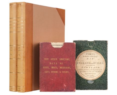
Lewis (Samuel). A Topographical Dictionary of Wales..., 2 volumes, 1834, title page to each volume, folding map of Wales and 12 uncoloured engraved county maps by J & C Walker, some offsetting, contemporary presentation inscription to first front blank, later endpapers, modern half calf gilt, large 4to, together with Kelly & Co. (& The Post Office Directory, publishers). Essex, Hertfordshire, Middlesex, Kent, Surrey & Sussex, circa 1875, together six lithographic maps with bright contemporary outline colouring, sectionalised and laid on linen, each approximately;y 650 x 1000 mm, contained in a contemporary red gilt cloth slipcase, slight wear to extremities of the case, with Cary (John). Cary's Reduction of his Large Map of England and Wales with part of Scotland..., circa 1830, engraved map with contemporary outline colouring, sectionalised and laid on linen, marbled endpapers, 765 x 630 mm, contained in a contemporary marbled calf slipcase with publisher's circular label to the upper cover, slight wear to extremitiesQTY: (4)

Aikin (John). A Description of the Country from thirty to forty miles round Manchester, London: John Stockdale, 1795, engraved frontispiece and additional title, two large folding engraved maps (including one hand-coloured map of country around Manchester few with closed tears and the other of Manchester), 43 engraved plates and 18 single-page maps and plans, one plate with long repaired closed tear, occasional light spotting, contemporary half calf, blind decorated spine, extremities rubbed, large 4toQTY: (1)
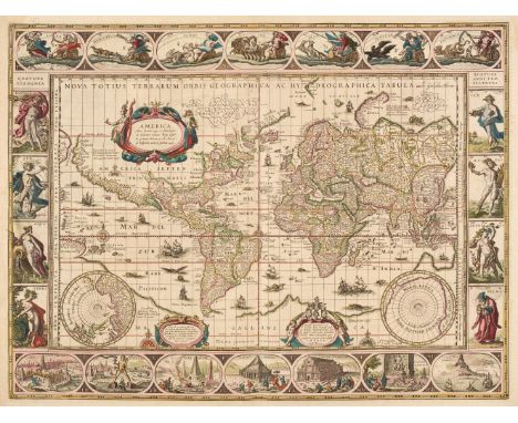
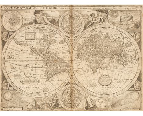
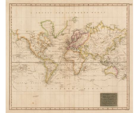
World. Blaeu (Willem Janszoon), Nova Totius Terrarum Orbis Geographica ac Hydrographica Tabula auct: Guilelmo Blaeuw, Amsterdam [1635 - 58], engraved map with contemporary hand-colouring, the upper margin with allegorical representations of the planets, the lower margin with the seven wonders of the world and the vertical margins with - on the right - the four seasons and on the left, the four elements, left-hand border trimmed to the plate mark and extended, very slight creasing, 410 x 540 mm, Latin text on verso QTY: (1)NOTE:R. W. Shirley. The Mapping of the World, number 255, state 4. One of the finest and most famous world maps to appear in an atlas during the Golden Age of Dutch cartography.
Kane (Richard). Campaigns of King William and the Duke of Marlborough; with remarks on the stratagems by which every battle was won or lost, from 1689, to 1712. Also a new system of military discipline, for foot in action, with the most essential exercise for cavalry, 2nd edition, London: printed for J. Millan, 1747, folding engraved map frontispiece (with closed tear and frayed margin), 18 engraved plates (one folding with split along one fold), a little light soiling and a few annotations, contemporary mottled calf gilt, a little rubbed, 8vo, together with Jones (Captain L.T.) An Historical Journal of the British Campaign on the Continent, in the Year 1794; with the retreat through Holland in the Year 1795, Birmingham: printed for the author by Swinney & Hawkins, 1797, subscribers' list, folding engraved map with outline colour (with tear, and repair to verso), 4 folding engraved plans, some light spotting and offsetting, hinges tender, bookplate of John Stewart, contemporary half calf, upper joint splitting, some edge wear, 4to, plus Hinde (Robert). The Discipline of the Light-Horse, 1st edition, London: printed for W. Owen, 1778, 2 engraved plates of light dragoons, 3 folding diagrams (two repaired), errata leaf at end, some light soiling, modern calf, 8vo, and Campaigns of 1796-97 between France and Austria... written exclusively for the officers reading at Sunbury, for the Staff Examination of July, 1866QTY: (4)

Capell Brooke (Arthur de). Travels through Sweden, Norway, and Finmark, to The North Cape, 2nd edition, London: J. Rodwell, 1831, 22 lithographs, 11 vignettes, occasional light spotting, contemporary calf, rebacked with original spine laid down (endpapers renewed), rubbed, 4to, together with:Hooker (William Jackson). Journal of a Tour in Iceland, in the Summer of 1809, London: Longman, Hurst, Rees, Orme, and Brown, 1813, half-title to volume 1, frontispieces to each (folding map to volume 2), 6 plates to rear volume 1, lightly spotted, original green cloth, some wear, 8vo, withMetcalfe (Frederick). The Oxonian in Norway; or, notes of excursions in that country in 1854-1855, 2 volumes, 1st edition, London: Hurst and Blackett, 1856, frontispiece to each, publisher's advertisements to rear of volume 1, library stamps to titles, lightly spotted, original brown blindstamped cloth gilt, library shelf numbers & stickers to spine bases, rubbed with some wear, 8vo, with 9 other travel volumes, including a 1st edition of Whymper's A Guide to Chamonix and the range of Mont Blanc in the original pictorial wrappers (1896)QTY: (13)

China. Jansson (Jan), China Veteribus Sinarum Regio nunc Incolis Tame dicta, Amsterdam, circa 1636, engraved map with contemporary outline colouring, very slight staining, central fold strengthened on verso, 410 x 500 mm, French text on versoQTY: (1)NOTE:The map depicts the eastern part of China (bounded in the northwest by the Great Wall), Korea is erroneously shown as an island together with the three main islands of Japan. The map also clearly illustrates the fictitious Chaimay Lacus with its numerous rivers flowing south into India and Siam.
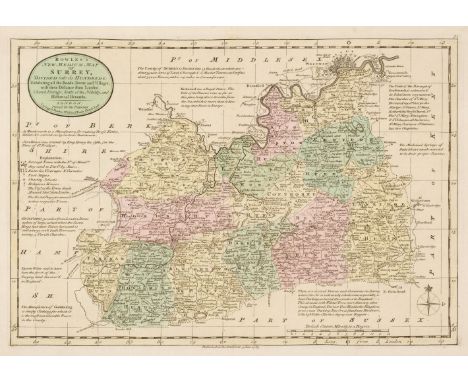
Surrey. Bowen (Emanuel & Kitchin Thomas), Bowles's New Medium Map of Surrey, Divided into its Hundreds..., 1785, engraved map with contemporary wash colouring, 230 x 335 mm, together with Lodge (John). A New Map of Surrey from the Latest Authorities, circa 1795, uncoloured engraved map published in the "Atlas of Great Britain and Ireland", 270 x 340 mm, with Darton (William). Surrey 1819 - [22], engraved miniature map with contemporary wash colouring, 75 x 115 mm, supplied with its page of contemporary descriptive text, plus Green (William). Surrey, [1804], engraved map with contemporary outline colouring, originally published in Green's scarce "Picture of England", 140 x 90 mm, and Johnson (Thomas). Surrey, published Manchester [186]3, lithographic map with bright contemporary wash colouring, small stain to the lower margin, 160 x 230 mm, with another seven small format county maps of Surrey, with examples by or after Smith, Teesdale, Phillips, Darton & Harvey, Morden Kitchin and Owen & Bowen, various sizes, good conditionQTY: (12)
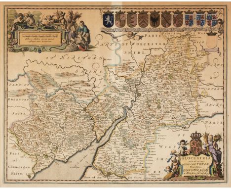
* British County Maps. A Collection of 40 maps, 17th - 19th century, including Valk (G. & Schenk P.). Glocestria Ducatus cum Monumethensi Comitatu Glocester Shire & Monmouth Shire, Amsterdam, circa 1700, engraved map with contemporary outline colouring, elaborate cartouche and mileage scale, some staining, 404 x 505 mm, mounted, framed and glazed, together with Ogilby (John). The Road from Bristoll to Worcester, [1676 or later], hand-coloured engraved strip road map, toned overall, 310 x 440 mm, mounted framed and glazed, with Morden (Robert). Cambridge, Somerset [and] Worcestershire [1695 or later], three engraved maps, one uncoloured (Worcestershire), each approximately 420 x 360 mm, mounted, framed and glazed, plus Blome (Richard). A General Mapp of the County of Hereford with its Hundreds..., circa 1673, uncoloured engraved map, old folds, some worming to the left-hand margin but not affecting the printed image, 310 x 285 mm, mounted, framed and glazed, with another 34 county, canal and road maps of Herefordshire, Worcestershire, Hampshire, Cornwall and Somerset, with examples by or after Cary, Wallis, Hall, Kitchin, Archer, Senex, Owen & Bowen, Gardner, Gibson, Rocque, Moule, Fullarton, The Gentleman's Magazine, Moll, Blome, Bowen/Meijer, Pigot and Lewis, various sizes and condition, all framed and glazedQTY: (40)
![China. Ortelius (Abraham), Chinae olim Sinarum regionis nova descriptio, auctore Ludovico Georgio, Antwerp [1603], hand-colou](https://cdn.globalauctionplatform.com/b3fbe50d-aae6-4645-8127-afcd00d44353/95c643f4-c585-4dd8-bc88-afcf00c987fa/468x382.jpg)
China. Ortelius (Abraham), Chinae olim Sinarum regionis nova descriptio, auctore Ludovico Georgio, Antwerp [1603], hand-coloured engraved map, orientated to the west, large strapwork cartouche and mileage scale, good margins, 370 x 470 mm, Latin text on versoQTY: (1)NOTE:Marcel van den Broecke. Ortelius Atlas maps, number 164. The first European map of China. The Second state, with "Les Philippinas" inserted above "Sinus Magnus".

Gorton (John). A Topographical Dictionary of Great Britain and Ireland..., 3 volumes, Chapman and Hall, 1833, additional half-titles, 54 double-page and folding maps by Sidney Hall, slight offsetting, hinges weak, bookplate of Sir William Bowyer Smith Bart., contemporary half calf gilt, contrasting labels to spines, slight wear to extremities and fraying to spines, 8vo, together with Kelly & Co. (publishers). The Post Office Directory of the Six Home Counties, Volume II contains Kent, Surrey & Sussex..., 1878, addenda tipped in before the title, three uncoloured lithographic maps, Kent torn with loss and crudely repaired, Surrey and Sussex with long closed tears repaired on verso, advertisements before each map and also to endpapers and pastedowns, the counties names stamped on the foredge, publisher's red blind-stamped cloth, stained and worn, spine torn with loss and repaired, large 8vo, with Post Office Directory of Cambridge, Norfolk and Suffolk with Essex, Herts, Kent, Middlesex, Surrey and Sussex, The Maps Engraved Expressly for the Work..., 1853, title page and preface, nine uncoloured double-page county maps, some trimming to the vertical margins, advertisements bound at rear, later endpapers with the original cloth gilt label attached to the front pastedown, modern cloth with the original title label to spine, large 8voQTY: (5)
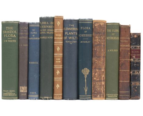
Flora. White (James Walter). The Flora of Bristol, 1st edition, Bristol: John Wright and Sons, 1912, folding colour map, 3 black & white plates, preliminary & rear leaves spotted, a few preliminary leaves trimmed with loss to outer margins, contemporary pencil ownership inscription to title upper margin, original green cloth gilt, lightly rubbed, 8vo, together with:Marquand (Ernest David). Flora of Guernsey and the Lesser Channel Islands, 1st edition, London: Dulau & Co, 1901, 5 maps, partially uncut, endpapers toned, original green cloth gilt, lightly rubbed, 8vo, withGreen (C. Theodore). The Flora of the Liverpool District, Abroath: T. Buncle, 1933, portrait frontispiece, black & white illustrations throughout, small library stamp to front free endpaper, original pictorial blue cloth gilt, library shelf sticker to spine base, marked, 8vo, with approximately 200 other floras on areas like Herefordshire, Dorset, Norfolk, Wiltshire, Lake District, Surrey, Gloucestershire etcQTY: (approx. 200)
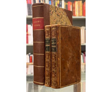
Anson (George). A Voyage Round The World, in the years MDCC, XL, I, II, III, IV, 2 Volumes in one, Glasgow: J. & M. Robertson and J. & W. Shaw, 1790, folding engraved map frontispiece showing California as an island (few discreetly repaired closed tears), browning and spotting to text, modern half sheep, 12mo, together with Voltaire, Poëmes, épitres et autres poésies, Londres [i.e. Paris: printed by Valade], 1779, engraved portrait frontispiece, and Voltaire, Contes et poésies diverse, Londres [i.e. Paris: printed by Valade], 1780, half-title with early signatures, all edges gilt, contemporary uniform mottled calf, gilt decorated spines with green morocco labels, extremities lightly rubbed, 12mo QTY: (3)

Africa. Blaeu (Willem Janszoon), Africae nova descriptio. auct: Guiljelmo Blaeuw. Amsterdam, circa 1640, engraved carte-a-figure map with contemporary hand-colouring heightened with gold, ten costumed figures to the vertical margins and nine oval vignettes of principal cities along the upper margin.410 x 550 mm, Dutch text on versoQTY: (1)NOTE:R. V. Tooley. Collector's Guide to the Maps of the African Continent and Southern Africa, page 29, plate 18. One of the most decorative and popular of all the early maps of Africa.
Speed (John). The Theatre of the Empire of Great Britaine. Presenting an Exact Geography of the Kingdomes of England. Scotland and Ireland and the Isles adjoyning..., Thomas Bassett & Richard Chiswell, 1676 bound with The Prospect of the most Famous parts of the World, viz. Asia, Africa, Europe, America with these Empires and Kingdoms therein contained..., Thomas Bassett & Richard Chiswell, 1676, engraved armorial frontispiece and additional decorative title (detached), letterpress general title printed in red & black, part titles to books two, three and four printed in black (Wales, Scotland and Ireland) and letterpress title to 'Prospect' also printed in black, preliminary text leaves including dedication present, 'A New and Accurat Map of the World...,' erroneously bound in after the contents page of 'The Theatre', ninety-six (complete) uncoloured engraved maps (68 in the Theatre and 28 in the Prospect), several maps trimmed with slight loss to the strapwork margin, very occasional marginal closed tears and staining, lacking the maps of Berkshire, Derbyshire and Shropshire, but replaced with examples from the first edition of 1611, map of Derbyshre stained and toned, Spain torn with loss to the upper right corner, Denmark torn with small area of loss to the right hand margin, each map with descriptive text to the verso, index bound at rear, additional armorial frontispiece and decorative title trimmed to neatline and attached to recto and verso of blank leaf at front of the volume, additional title page loosely inserted, 18th-century bookplate of James Norman and old auction catalogue entry to the front pastedown, front free endpaper with ink stamp of I. Pickersgill, hinges and joints weak and cracked, rear board near-detached, 18th-century sheep, rubbed and worn, folioQTY: (1)NOTE:Chubb, XXVII. John Speed's 'Theatre' is regarded as a landmark in the history of British topography. It was the first English attempt to produce a grand scale atlas, including the first maps of the provinces of Ireland. The 'Theatre' evolved into a world atlas with the addition of the 'Prospect' in 1627. The 1676 edition of the Prospect includes seven new maps which were not present in the 1627 edition: Virginia and Maryland, New England, Carolina, Jamaica and Barbados, East India, Russia and Canaan.
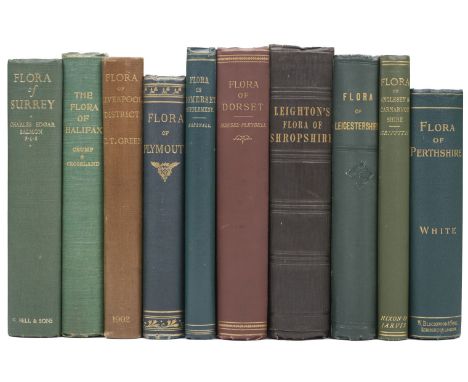
Flora. Salmon (Charles Edgar). Flora of Surrey, 1st edition, London: G. Bell & Sons, 1931, portrait frontispiece, 8 black & white illustrations, 2 folding maps to rear, original green cloth gilt, 8vo, together with:Crump (William B, & Charles Crossland). The Flora of the Parish of Halifax, 1st edition, Halifax: Halifax Scientific Society, 1904, half-title, vignette title, original green cloth gilt, lightly rubbed, 8vo, withGriffith (John E). The Flora of Anglesey & Carnarvonshire, 1st edition, Bangor: Nixon and Jarvis, [1895], folding map in colour, original blindstamped green cloth gilt, 8vo, withBriggs (T. R. Archer). Flora of Plymouth: An Account of the Flowering Plants and Ferns, 1st edition, London: John Van Voorst, 1880, colour folding map frontispiece, ALS from author & newspaper cutting mounted to front blanks, bookplate of John Shelley to front pastedown, spotting, original green blindstamped cloth gilt, lightly rubbed, 8vo, with Chater (A.O). Flora of Cardiganshire, Aberystwyth, A.O. Chater, 2010, colour frontispiece, illustrated throughout (many in colour), original blue paper boards, 4to, withPurton (T). A Botanical Description of British Plants, in the Midland Counties, 3 volumes (including appendix), Stratford-Upon-Avon: J Ward, 1817-21, half-titles, hand-coloured engraved plates throughout, light occasional toning, endpapers renewed, modern blue buckram gilt, 8vo, with approximately 150 other floras, including works on Oxfordshire, Middlesex, Derbyshire, Cheshire, Buckinghamshire, Sussex, Shropshire, Leicestershire, Yorkshire etcQTY: (approx. 150)
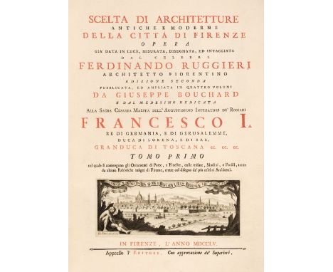
Ruggieri (Francesco). Scelta di Architetture Antiche e Moderne della Citta di Firenze, Opera gia date in luce, misurata, disegnata, ed intagliata dal celebre Ferdinando Ruggiero, Architetto Fiorentino, Edizione Seconda, pubblicata, ed ampliata in quattro volumi da Giuseppe Bouchard, 4 volumes bound in two, Florence, Appresso l'Editore, 1755, four additional engraved titles, four printed titles in red and black, with engraved vignette to each, large folding engraved map of Florence, three unnumbered engraved portraits of Nelli, Michelangelo and Rossi, and 279 fine copper engraved plates, including many double-page, engraved head-pieces, etc., engraved bookplate of Joseph Augustin Brentano to front pastedown of each volume, and later printed bookplate of Leo S. Olschki, Firenze to upper outer corner of front pastedown of first volume, short closed tear to lower margin of engraved title to first volume, fine contemporary marbled full calf, gilt-decorated spines, rubbed and joints partly cracked at head and foot, with minor wear to extremities, large folio (49 x 37 cm)QTY: (2)NOTE:Provenance: (1) Joseph Augustin Brentano (1753-1821), Dutch merchant and art collector of Italian descent, who traded with both the Dutch East India Company and Dutch West India Company. His large art collection included paintings by Rembrandt, Rubens and Hals, as well as Italian painters including Titian, Raphael and Annibale Carracci. He founded an old people's home (Brentano's Steun des Ouderdoms), funded by the posthumous sale of his collection of 400 paintings, as well as books and other rarities, in 1824. (2) Leo Olschki (1861-1940), bookseller and publisher, who founded the Leo S. Olschki publishing house in Verona (later Venice and Florence) in 1886.Millard Architectural Collection (Italian and Spanish Books) 118. Berlin Katalog 2690. Cicognara 639.A fine copy, lavishly printed on thick paper, of this monumental work on the architecture of Florence. The second edition was published by the Frenchman Joseph Bouchard, using the original copper plates from the first edition of 1722-28. This edition is the first to combine three separately published works by Ruggieri: the three volumes of Studio d'architettura civile sopra gli ornamenti di porte, e finestre... (1722-1778), V descrizione e studi della insigne fabbrica di S. Maria del Fiore... (1733), and La Libreria Mediceo-Laurenzinia Architecttura di Michelagnolo Buonarroti... (1739).Ruggieri's map of Florence included in this work, was the first original plan of the city since Buonsignori's Plan of 1584.Born in 1687, Ruggieri studied under Giovanni Battista Forggini in Florence and became a member of the Florentine Accademia del Disegno in 1718. The most distinguished architect of Florence of his day Ruggieri, best known for his facade of the Church of San Firenze.

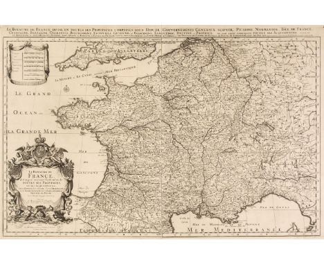
* France. Jaillot (Alexis-Hubert). Le Royaume de France Distingué Suivant l'Estendue de Toutes ses Provinces, et ses Acquisitions dans l'Espagne, dans l'Italie, dans l'Allemagne, et dans la Flandre, l'Artois, le Haynaut, Le Namur, et Le Luxembourg, Provinces des Pays-Bas, Paris, 1692, large uncoloured engraved map based on an earlier map by Nicolas Sanson, printed on two conjoined sheets, large decorative cartouche and mileage scale, additional title to the upper margin, near-contemporary manuscript number '4' to the upper right margin, 585 x 895 mm, mounted, framed and glazed, together with Le Compté D'Artois..., Paris 1693, large uncoloured engraved map on two conjoined sheets, large decorative cartouche and mileage scale, additional title to the upper margin, 550 x 850 mm, mounted, framed and glazedQTY: (2)NOTE:Pastoureau, M. Jaillot I-D, 11. The date of 1692 indicates that this map is from the counterfeit edition, published in Amsterdam by Pierre Mortier.

* Chatelain (Henry Abraham). Nouvelle Carte d'Angleterre, d'Ecosse, et d'Irlande, avec des Instructions pour Connoitre les Differents Etats de la Couronne d'Angleterre en Europe, Asie, Afrique, et Amerique, circa 1719, uncoloured engraved map of the British Isles, two inset circular maps of the western & eastern hemispheres, old folds, 475 x 630 mm, mounted, framed and glazed, together with Nouvelle Carte pour servir a L'Histoire de L'Empire D'Occident depuis les Premiers Empereurs Romains..., circa 1719, uncoloured engraved map of Europe, two large inset tables, old folds, slight creasing, 505 x 600 mm, mounted, framed and glazed, with De L'Isle (Guillaume), Theatrum Historicum ad annum Christi quadringentesimu in quo tum Imperii Romani tu Barbarorum..., Paris, 1780, engraved map with contemporary outline colouring, inset circular map of the Americas, 490 x 655 mm, mounted, framed and glazedQTY: (3)
Badeslade (Thomas & William Henry Toms). [Chorographia Britanniae. Or a set of Maps of all the Counties in England and Wales, London, 1741], lacking printed title, four engraved general maps of England & Wales, 5 pages of tables and 42 (complete) uncoloured double-page maps, slight spotting throughout, text block broken, a few leaves detached, contemporary diced calf, boards detached, rubbed and worn, 8vo, together with Wallis (James). Wallis's New Pocket Edition of the English Counties or Travellers Companion in which are carefully laid down all the Direct & Cross Roads, Cities, Townes, Villages, Parks, Seats and Rivers with a General Map of England & Wales published J. Wallis and sold by Davies & Eldridge, Exeter [1810], letterpress title and contents list, forty-two (of 43, lacking Somerset) engraved maps with contemporary hand colouring, including 1 double-page (Yorkshire), plus a small map of the Isle of Wight, some dust soiling throughout, occasional spotting, near contemporary signatures and annotations to the verso of several maps, some pencil juvenile scribbling to rear endpapers and pastedown, text block broken and split, contemporary half morocco, boards detached, lacking spine, heavily worn and rubbed, small 12mo, with Owen (John & Bowen Emanuel). Britannia Depicta: or Ogilby Improved..., 1764, title page and 91 (only) engraved county maps and strip road maps (printed back-to-back), each sheet approximately 190 x 140 mm, disbound, lacking preliminaries, endpapers, boards and spineQTY: (93)NOTE:The first volume described Chubb CLXX. The second Chubb. CCCXLIV. Sold as a collection of maps, not subject to return.
Wales. Jansson (Jan), Principatus Walliae pars Borealis vulgo North Wales, Amsterdam circa 1650, engraved map with contemporary outline colouring, short splits at the base and head of the central fold, slight staining and dust soiling, 405 x 515 mm, German text on verso, together with Blaeu (Johannes). Montgomeria comitatus et Comitatus Mervinia, Amsterdam, circa 1645, uncoloured engraved map, decorative cartouche and mileage scale, slight staining to the margins but not affecting the image, 385 x 500 mm, Latin text on verso, with Comitatus Brechiniae; Breknoke, Amsterdam circa 1645, engraved map with contemporary outline colouring, decorative cartouche and mileage scale, slight staining to the margins but not affecting the image, central fold repaired on verso, 380 x 505 mm, Latin text on verso, plus Speed (John). Breknoke both Shyre and Town described, Thomas Bassett & Richard Chiswell [1676], uncoloured engraved map, inset town plan of Brecknock, large strapwork cartouche, central fold frayed, toned and worn with slight loss, slight marginal staining, 385 x 510 mm, English text on versoQTY: (4)
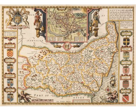
Speed (John). Suffolk, Suffolke Described and Divided into Hundreds, The Situation of the fayre towne Ipswich shewed, with the Armes of the most noble families that have bene either Dukes or Earles both of that Countie as also of Clare, 1st edition, George Humble, circa 1611, hand-coloured engraved map, inset town plan of Ipswich, right-hand margin frayed with some loss to the strapwork border, vertical margins professionally repaired and extended, central fold repaired on verso, the whole backed with archival tissue, 385 x 515 mm, English text on verso, together with The Countie of Warwick The Shire Towne and Citie of Coventry Described, Thomas Bassett & Richard Chiswell [1676], hand-coloured engraved map, inset town plans of Warwick and Coventry, frayed and worn with some loss to the printed image, repaired on the verso, the whole backed with archival tissue, 385 x 510 mm, English text on verso, with Stafford Countie and Towne with the ancient Citie Lichfield described, Thomas Bassett & Richard Chiswell [1676], hand-coloured engraved map, inset town plans of Stafford and Lichfield, central fold and lower margin strengthened and repaired on verso, some faded near-contemporary manuscript text to the margins on the recto and verso, 385 x 515 mm, English text on verso, plus The West Ridinge of Yorkeshyre with the most famous Citie Yorke described, Henry Overton circa 1710, hand-coloured engraved map, inset town plan of York, large margins, toned overall and laid on later card, 385 x 515 mmQTY: (4)
![London. Lewis (Samuel). [Atlas to the Topographical Dictionary of England] circa 1844, lacking title and preliminaries, uncol](https://cdn.globalauctionplatform.com/b3fbe50d-aae6-4645-8127-afcd00d44353/544af73b-4e4a-43d0-a004-afcf00c99168/468x382.jpg)
London. Lewis (Samuel). [Atlas to the Topographical Dictionary of England] circa 1844, lacking title and preliminaries, uncoloured folding engraved map of England and Wales and London and 42 (only) engraved county maps, some folding, some spotting throughout, some maps detached, upper hinge broken, contemporary cloth, lacking spine, 4to, together with Tegg (T. T. & J. publishers). New Plan of London &c. with 360 references to the Principal Streets etc. circa 1832, engraved map with contemporary outline colouring, sectionalised and laid on linen, slight staining, short split along one old linen fold, 440 x 625 mm, contained in a contemporary marbled card slipcase with publisher's green & black label to the upper cover, some wear to the extremities of the slipcase, with Crutchley (G. F.). A New & Improved Map of the Environs of Windsor extending from 14 to 18 Miles round the Castle, J. B. Brown, Book & Print Seller to the Royal Family Windsor, circa 1830, engraved map with bright contemporary wash colouring, sectionalised and laid on linen, 300 x 240 mm, bound in contemporary green gilt cloth boards, plus another approximately 75 late 19th & 20th-century folding maps of London and its environs, with examples by or after Bacon, Ordnance Survey, Philips, Gall & Inglis, Smith & Son, W H Smith, "Geographia", Kelly, Bowen and Stanford, various sizes and conditionQTY: (approx. 80)NOTE:The second item described. Howgego number 295, state 8.
Scotland. Bartholomew (John), Black's New Large Map of Scotland compiled from the Ordnance, Admiralty & other Surveys, A & C Black, 1862, twelve colour lithographic map sheets, each sectionalised and laid on linen, very slight staining, endpapers with near-contemporary manuscript annotations, each sheet approximately 490 x 500 mm, contained in a contemporary green cloth slipcase, some wear to extremities of the case, together with Blackwood (William). Blackwood's Atlas of Scotland: Containing Twenty-Eight Separate Maps of the Counties, together with the Orkney, the Shetland and the Western Isles and a General Map of Scotland, 1847, printed title with some damp staining, folding map of Scotland and thirty engraved maps (lacking Kincardineshire), all with contemporary outline colouring, some staining and spotting throughout, hinges and joints weak and cracked, contemporary black morocco gilt 'envelope style' binding, rubbed and worn, 8vo, with Wilson (Rev. James Marius). The Imperial Gazetteer of Scotland; or Dictionary of Scottish Topography..., 2 volumes, A. Fullarton, 1854 - 57, additional decorative half-title, folding map of Scotland with handling tears, crudely repaired with sellotape on verso, 31 engraved county maps by Archibald Fullarton, all with contemporary outline colouring, 7 plans and numerous coloured topographical plates, slight staining throughout, contemporary half calf gilt with contrasting morocco gilt labels to spines, bumped and with slight wear, large 8vo, plus Philip (George & Son). Philip's Atlas of the Counties of Scotland; A Series of Twenty-Seven Maps, 1858, title page with near-contemporary ownership signature, contents list, 27 engraved county maps and a folding general map of Scotland (complete as list), contemporary blind stamped cloth with gilt title to the upper siding, some wear to extremities, small 8vo, QTY: (5)

Genoa. Carte Particuliere de Genes et de ses Environs, circa 1720, uncoloured, separately published and unattributed engraved map of Genoa, key to both of the vertical margins and an inset map of the port to the lower left corner, an ornate crest of the Doge within the title banner, some creasing and dust soiling, slight spotting, right-hand vertical border extended, old adhesion scaring to the verso, 405 x 550 mmQTY: (1)NOTE:A scarce separately published plan of Genoa. WorldCat lists only two institutional copies.

Said-Ruete (Rudolph). Said bin Sultan, 1st edition, London: Alexander-Ouseley, 1929, 6 black & white illustrations, folding map to rear, ex-library with stamps throughout (including to title, plate versos), original green cloth gilt, ex-library blindstamp to front board, library gilt shelf mark to backstrip, rubbed, 8voQTY: (1)
Asia. Coronelli (Vincenzo Maria), Asia Divisa nelle sue Parti secondo lo stato presente.., Venice, circa 1690, hand-coloured engraved map on two conjoined sheets, large decorative cartouche and mileage scale, slight marginal staining, 610 x 890 mmQTY: (1)NOTE:Originally published in the "Atlante Veneto, nel quale si contiene la descrittione...,". The map details the discoveries of Abel Tasman around Australia and those made by Maarten de Vries to the north of Japan

* Pennant (Thomas). Journey to Snowdon, London: Printed by Henry Hughes, 1781, engraved title, 20 plates (including supplementary plates, one folding), occasional spotting and toning, endpapers renewed, contemporary speckled calf, rebacked, 4to,Pennant (Thomas), A Tour in Wales, London: Printed by Henry Hughes, 1778, engraved title with armorial bookplate of the Hon. James Yorke to verso dated 1808, 26 engraved plates (some folding), some scattered spotting and occasional offsetting, contemporary calf, joints split and some wear to extremities, 4toPennant (Thomas), The View of India Extra Gangem, China, and Japan (Outlines of the Globe, volume III only), London: printed by Luke Hansard, sold by John White, 1800, half-title, folding engraved map frontispiece (few short closed tears to folds), occasional small ink stamps to text & one to verso of map, modern brown morocco, 4to, plus a defective copy of Caradoc of Llancarvan, [The History of Wales: Comprehending the lives and succession of the Princes of Wales, from Cadwalader the last king, to Lhewelyn the last prince, of British blood..., 1697], lacking title, following preliminary leaf and final eight leaves at rear, few marginal notes and pencil notes to rear free endpaper (possibly in the hand of Thomas Pennant(?), refer to early 20th-c. bookseller's catalogue entry to front pastedown), dust-soiling throughout, early 19th-century half sheep, worn, 8voQTY: (4)
![British Isles. Blaeu (Johannes), Insulae Albion et Hibernia cum minoribus adjacentibus [1654], engraved map of the British Is](https://cdn.globalauctionplatform.com/b3fbe50d-aae6-4645-8127-afcd00d44353/a7bd2187-7162-4366-9758-afcf00c9812a/468x382.jpg)
British Isles. Blaeu (Johannes), Insulae Albion et Hibernia cum minoribus adjacentibus [1654], engraved map of the British Isles on a Ptolemaic projection with contemporary outline colouring, large margins, 380 x 445 mm, Latin text on verso, together with Mercator (Gerard). Tab. I. Europae Continens Albion Britanniam et Hiberniam [1578 but 1730 edition], hand-coloured engraved reticulated map, 340 x 405 mm, no text on verso, with Ruscelli (Girolamo). Tabula Europae I, 1564, uncoloured engraved map on a trapezoidal projection, slight staining, 190 x 265 mm, with another slightly later coloured example of the second state from circa 1598, plus two other Ptolemaic projections of the British Isles by John Seller and John Horsley, various sizes, good conditionQTY: (6)

Black's Colour Guides. Younghusband (Francis). Kashmir, London: Adam and Charles Black, 1911, colour frontispiece, colour illustrations (with captioned tissue-guards), folding map to rear, publisher's advertisements to rear, lightly spotted, original red cloth gilt, top edge gilt, lightly rubbed, 8vo, together with Kelly (R. Talbot). Egypt, painted and described, London: Adam and Charles Black, 1902, colour frontispiece, colour illustrations (with captioned tissue-guards), lightly spotted, original blue cloth gilt, top edge gilt, lightly rubbed, 8vo, with Palmer (W.T). The English Lakes, London: Adam and Charles Black, 1908, colour frontispiece, colour illustrations (with captioned tissue-guards), lightly spotted, original grey cloth gilt, lightly rubbed, 8vo, with 72 other A. & C. Black colour guides and similarQTY: (75)
Ogilby (John). The Road from London to Aberistwith on the Sea Coast com. Cardigan, The Continuation of ye Road from London to Aberistwith Plate ye Second commencing at Islip com. Oxford..., The Continuation of the Road from London to Aberistwith, The Extended Road from Oakham to Richmond in Yorkshire, The Continuation of the Road from York to Wets-Chester [and] The Road from Glocester to Montgomery North Wales [1676 or later], together six uncoloured engraved strip road maps, the first map described with a cartouche showing a surveyor using a waywiser, some creasing, slight marginal fraying and spotting, each approximately 315 x 435 mmQTY: (6)NOTE:The map sheet numbers are 1, 2, 3, 48, 90 & 71.

Symes (Michael). An Account of an Embassy to the Kingdom of Ava, sent by the Governor-General of India in the Year 1795, 1st edition, London: printed by W. Bulmer and Co., 1800, half title, 2 folding engraved maps, 26 engraved plates (plates 16 & 24 biopredated with some loss), a few plates repaired towards end, pp. 477-78 with marginal biopredation, some plates with water stains, some offsetting and marginal stains, endpapers renewed, original drab boards, rebacked, some stains and edge wear, 4to, together with Kinloch (Alexander A.A.) Large Game Shooting in Thibet, the Himalayas, and Northern India, 1st edition, Calcutta: Thacker, Spink & Co., 1885, folding map (with closed tears), photogravure illustrations, 16 pp. publisher's catalogue at end, occasional light spotting, small presentation and excised signature to front endpaper, original cloth gilt, joints and edges a little rubbed, 4toQTY: (2)
Thomson (John). A New General Atlas, consisting of a series of geographical designs on various projections, exhibiting the form and component parts of the Globe; and a collection of maps and charts, delineating the natural and political divisions of the empires, kingdoms, and states in the World. Constructed from the best systematic works, and the most authentic voyages and travels. With a memoir of the progress of geography, a summary of physical geography, and a consulting index to facilitate the finding out of places, Edinburgh: Printed by George Ramsay and Company, for John Thomson and Company, Edinburgh; Baldwin, Cradock, and Joy, London; and John Cumming, Dublin, 1817, printed title with some spotting, dedication to Alexander Keith of Dunottar and Ravelston, list of maps and charts, 23 pages of introductory text and 22 pages of a consulting index, double-page comparison plate, 76 (of 74 engraved double-page and folding maps with duplicates of the maps of the Prussian Dominions and of Arabia), all with contemporary outline colouring, some off-setting and slight spotting, some staining throughout, a few maps frayed at the margins, chart of the North Atlantic Ocean with closed tear, each map with a small contemporary paper numeral pasted to the upper right corner, marbled endpapers, contemporary half morocco gilt, scarred and worn, folio (555 x 435 mm) QTY: (1)NOTE:The largest atlas published in Scotland at the time, Thomson's atlas is distinguished by its map of Europe in four sheets, the several sheets devoted to the major islands of the West Indies, as well as fine detailed maps of the Arabian peninsula, Japan and Korea, and Australia.
Railton (John). The Army Regulator: or, the Military Adventures of Mr. John Railton; giving an account of his particular services in the Horse Grenadiers, the Dragoons, the Foot, and the Train of Artillery, London: printed for W. Warner, O. Payne, J. Jackson & J. Vokes, 1738, woodcut head-and tail pieces and initials, occasional slight soiling, modern calf, 8vo, together with:[Bever, Samuel]. The Cadet. A Military Treatise, 1st edition, London: printed for W. Johnston, 1756, folding engraved plate (one fold reinforced to verso), front blank bound after title, light toning front and rear, modern calf 8vo, plus two others: An Essay on Defensive War, and a Constitutional Militia... [by Michael Dorset], 1st edition, 1788, and Campaigns of King William and the Duke of Marlborough, by Brigadier-General Richard Kane, 2nd edition, 1747, with map and 16 plates only (of 18)QTY: (4)NOTE:ESTC T22423 (a re-issue of the first printing from the same date); T134343; T144289; T124053 respectively.
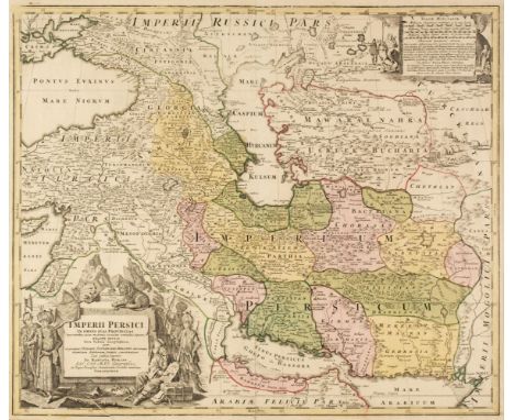
* Persia. Homann (Johann Baptist), Imperii Persici in Omnes suas Provincias..., Nuremberg, circa 1720, engraved map with contemporary outline colouring, large allegorical cartouche and mileage scale, one short printer's fold, 490 x 580 mm, mounted, framed and glazed, together with Schenk (Petrus) Imperii Persici Delineatio ex Scriptus Potissimum Geographicis Arabum et Persarum Tentata ab Adriano Relando, Amsterdam, 1705, engraved map with contemporary outline colouring, large allegorical cartouche, 490 x 570 mm, mounted, framed and glazedQTY: (2)
![Bible [English]. The Holy Bible, containing the Old Testament and the New: Newly Translated out of the Originall Tongues: and](https://cdn.globalauctionplatform.com/b3fbe50d-aae6-4645-8127-afcd00d44353/a6850694-0775-4c0a-a37c-afcf00c9f001/468x382.jpg)
Bible [English]. The Holy Bible, containing the Old Testament and the New: Newly Translated out of the Originall Tongues: and with the former translations diligently compared and revised, by his Maiesties special commandment. Appointed to be read in Church, Imprinted at London by Bonham Norton and John Bill, 1622, general and New Testament titles within woodcut borders (NT title omits the words 'Appointed...'), Apocrypha present, colophon dated 1623, some close trimming to few running titles (mostly to leaves in New Testament), bound with at front The Genealogies recorded in the Sacred Scriptures, according to every Family and Tribe. With the line of Our Saviour Jesus Christ, observed from Adam to the Blessed Virgin Mary, by J[ohn] S[peed], [London, 1623?], woodcut genealogies incorporating woodcut illustration of Adam and Eve in the Garden of Eden, including double-page woodcut map of the Holy Land, title to genealogies guarded, some light dust-soiling and few minor marks, marbled endpapers, 18th-century marbled calf gilt, maroon morocco title label, joints cracked, rubbed with some wear to extremities, 4to (21.6 x 15.5 cm)QTY: (1)NOTE:Herbert 388; Darlow and Moule 298; STC 2265.Both titles dated 1622, but colophon dated 1623.
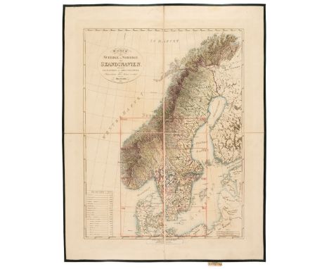
Scandinavia. Forsell (Carl Gustaf), Karta ofver Sodra Delen af Sverige och Norrige eller det fordna sa Kallade Skandinavien..., Stockholm 1815 - 26, large scale engraved map of southern Scandinavia on eight sheets, contemporary outline colouring, sectionalised and laid on linen, all edged in green silk, slight offsetting, together with a key plate map, each map sheet with a map seller's label (James Wyld) to the verso, each sheet approximately 610 x 850 mm, key map 550 x 420 mmQTY: (9)NOTE:An uncommon large-scale map of Southern Scandinavia.
![Asia. Ortelius (Abraham), Asiae Nova Descriptio, [1575 or later], engraved map with contemporary outline colouring, large st](https://cdn.globalauctionplatform.com/b3fbe50d-aae6-4645-8127-afcd00d44353/68728298-f98e-4a13-9816-afcf00c97dd2/468x382.jpg)
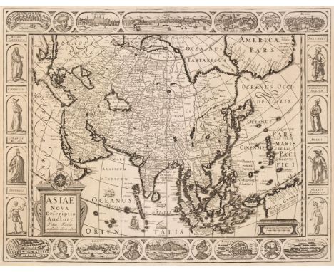
Asia. Ortelius (Abraham), Asiae Nova Descriptio, [1575 or later], engraved map with contemporary outline colouring, large strapwork cartouche, large margins, slight dust soiling to the margins, 370 x 490 mm, Latin text on versoQTY: (1)NOTE:Marcel van den Broecke. Ortelius Atlas Maps, number 7. An example of the second plate (of 2), which is distinguished by the lowercase 'f' in farfana in the top right corner, to the east of Japan, the lack of 'cum privilegio' in the lower-left corner and the disappearance of the town of Ara, to the north-west of Aden.

Asia. Mercator (Gerard), Asia ex Magna Orbis Terre Descriptione Gerardi Mercatoris Desumpta, Studio et Industria G.M. Iunioris [1604 or later], engraved map with bright contemporary outline colouring, large and ornate strapwork cartouche, slight staining, one small closed tear affecting the image, repaired on verso, 375 x 465 mm, French text on versoQTY: (1)

Camden (William). Britain, or a Chorographicall Description of the Most Flourishing Kingdomes, England, Scotland, and Ireland, and the Islands adjoyning, out of the depth of Antiquitie: Beautified with Mappes of the Several Shires of England..., William Aspley, 1637, frontispiece of a decorative map of the British Isles with repaired closed tear, letterpress title, 8 engraved plates of coins, 57 (complete) engraved folding maps by G. Hole and W. Kip, 54 with contemporary outline colouring (Cornwall, Surrey and Gloucestershire uncoloured), small hole affecting the printed image of Wiltshire, Durham and Berkshire, index bound at rear, later endpapers, modern calf with contrasting gilt calf label to spine, slight wear and staining to sidings, folio. QTY: (1)NOTE:Chubb XX. Uncommon to find a copy with contemporary colouring.

Leicestershire. Darton (William & Dix Thomas). Leicestershire Divided into Hundreds and the Parliamentary Divisions, William Darton & Son, circa 1819, engraved map with contemporary outline colouring, sectionalised and laid on linen, uncoloured inset vignette of Belvoir Castle, slight offsetting, 370 x 455 mm, contained in a contemporary cloth slipcase with publisher's printed label to the upper siding, together with another later copy (circa 1840), with the 'new' railways added to the map, bound in contemporary red cloth gilt boards with the title "The Post Office Map of Leicestershire Dedicated to Rowland Hill Esqr." to the upper siding, with Bickham (George). Leicestershire, [Laurie & Whittle, circa 1796], uncoloured engraved pictorial view of the county, published in "A Curious Antique Collection of Birds-Eye Views of Several Counties", slight marginal chipping, 230 x 155 mm, plus Bowen (Emanuel). An Accurate Map of the Counties of Leicester and Rutland Divided into their respective Hundreds..., J. Tinney, R. Sayer, T & J Bowles & Son, 1756, engraved map with contemporary outline colouring, sectionalised and laid on linen, 540 x 700 mm, contained in a contemporary marbled card slipcase with printed label to the upper cover, some wear to the slipcaseQTY: (4)

Northern Pacific Ocean. Zatta (Antonio), Nuove Scoperte de' Russi al Nord del Mare del Sud si nell' Asia, che nell' America, Venice 1776, engraved map with contemporary outline colouring, 315 x 410 QTY: (1)NOTE:A good - if a highly speculative piece of cartography - of Zatta's rendition of a map of the northwest passage and the Bering Straits. Clearly shown are two broad seaways leading from the Pacific Ocean into Hudson's Bay; they are based upon the mythical voyages of Admirals Cluny and de Fonte. The chart shows the northwest coast of North America and the northeast coast of Asia, but it is scattered with several cartographic anomalies. Alaska is broken up into a group of islands and the coastline of North America is dissected by fictitious rivers and waterways. Clearly annotated is 'Fou-Sang Colonia de Chinesi', a fictional colony, based on the theory that the Chinese colonised North America in the 5th century. The map is dominated by a large cartouche of an island, incongruously populated by creatures more usually found in Africa, including an ostrich, a rhinoceros an elephant and a crocodile.
![British Isles. Muster (Sebastian). Tabula Britanniae, Basle [1578 but a 1621 edition], an uncoloured woodblock 'Ptolemaic' ma](https://cdn.globalauctionplatform.com/b3fbe50d-aae6-4645-8127-afcd00d44353/797ab8e1-17f6-4847-bf89-afcf00c983a0/468x382.jpg)
British Isles. Muster (Sebastian). Tabula Britanniae, Basle [1578 but a 1621 edition], an uncoloured woodblock 'Ptolemaic' map on a trapezoidal projection, 280 x 360 mm, Latin text on versoQTY: (1)NOTE:R. W. Shirley. Early Printed Maps of the British Isles. 27 - 378 (a). A scarce late variant of Munster's Ptolemaic map of the British Isles, published in Strabo's 'Strabonis rerum geographicarum libri septemdecim'.
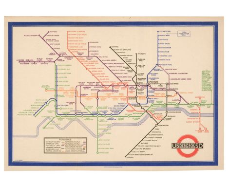
London Underground. Beck (H. C.). Map of London's Underground Railways, (750M 1-33), 1st edition, Waterlow & Sons Ltd. London, Dunstable & Watford, 1933, colour photolithographic map of the London Underground in pocket format, the first edition of Beck's iconic map, old folds, list of 'theatres' and 'places of interest' to the verso, 160 x 225 mm, together with another five later editions of the same map (4th edition 1933, 1st edition 1935, 1st edition 1936, 2nd edition 1936 & 1st edition 1937), all with old folds and the same size, with thirteen further issues dating from 1938 to 1958, plus another nineteen examples from 1961 to 1979 and a further forty-nine examples from the 1970s to the early 2000s, and another 20 later editions and ephemera, all contained in a modern sleeved ring binder, plus a box containing approximately 210 further editions from the 21st century and approximately 90 publications and maps relating to London and London Transport, some duplicates, various sizes, good conditionQTY: (approx. 400)NOTE:The cover of this first edition states "A new design for an old map. We should welcome your comments”. A cautious and uncertain note for a map that was to become one of the most innovative and successful designs of all time. Beck's design was initially rejected when it was first presented to the Underground Group's Publicity Department in 1931 and the cover note reflects that they were still uncertain as to how the public would react to such a revolutionary representation.Beck was only 29 years old and temporarily employed as a draughtsman, but he understood that passengers didn't need a geographically accurate map whilst travelling underground and would simply need to know the sequence of stations and where to change. Beck abandoned geographical accuracy for schematic rules similar to those found on electrical circuit diagrams. It is a reflection on the genius of Beck's design that it has stood the test of time, becoming one of the world's most famous cartographic designs and profoundly changed the relationship between the travelling passenger and the city. For this transformational design - that would change transport mapping across the world - Beck was paid 10 guineas - the equivalent of a week's wages and London Transport had secured one of the greatest pieces of 20th-century cartography for little more than loose change.
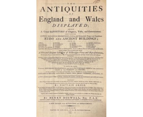
Boswell (Henry). The Antiquities of England and Wales Displayed..., new edition, with alterations and improvements, London: Alex Hogg, 1795, engraved frontispiece, 21 engraved maps only (some detached), numerous engraved plates, contemporary marbled calf, boards detached, worn, folio, together with:Wood (John George), The Principal Rivers of Wales illustrated; consisted of a series of views from the source of each river to its mouth..., part 2 only, London: Printed for the author, by T. Bensley, 1813, two hand-coloured double-page folding maps, 68 sepia soft-ground etched plates (including 27 coloured including 8 double-page), some damp staining at foot of some leaves, contemporary black half calf, gilt decorated spine, joints split and with old repairs, folio, and Newbery & Carnan (Publishers), A description of England and Wales containing a particular account of each county, volumes 2-4 & 6-10 only, London, 1769-70, numerous engraved plates, wood engraved vignette illustrations, contemporary calf, maroon morocco title label to spine of each, wear to extremities, 12mo, and a folding hand-coloured engraved map of England & Wales by J. & C. Walker, circa 1840, sectionalised on linen, heavily varnish to printed surface, plus Bacon's "Excelsior" Memory-Map Atlas, 1906QTY: (12)

* Middlesex. Speed (John), Midle-sex described with the most famous Cities London and Westminster, Thomas Bassett & Richard Chiswell, [1676], hand-coloured engraved map, inset town plans of Westminster and London, inset views of Saint Peters and Saint Pauls, central fold repaired, repaired marginal closed tears, light overall toning, 385 x 510 mm, mounted, framed and glazed, together with Morden (Robert). Midlesex [1695 or later], hand-coloured engraved map, 370 x 430 mm, mounted, framed and glazedQTY: (2)

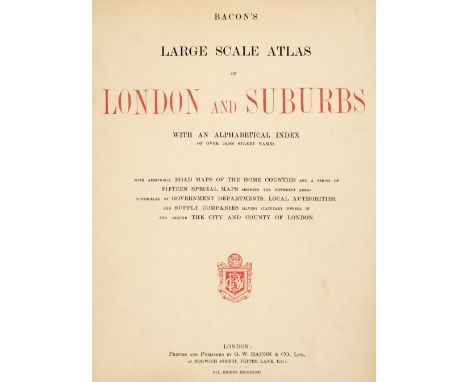
Bacon (G. W. publisher). Bacon's Large Scale Atlas of London and Suburbs..., with an Alphabetical Index..., circa 1930s, title and contents list, contents page with long closed repaired tear, 7 lithographic double-page county maps, 25 maps of London, index maps and 34 sheet map of London, publisher's half morocco, worn and rubbed, hinges and joints weak and cracked with the upper board near detached, folio, together with Commercial and Library Atlas of the World with Index-Gazetteer, circa 1890, additional half-title, title page with some spotting, preface and index, frontispiece of 'The Flags of all Nations' and 100 colour lithographic maps and diagrams, slight dust soiling, index bound at rear, later endpapers, modern half morocco but retaining the contemporary boards, slight staining to the sidings, folio QTY: (2)

* Persia. Seutter (Matthaus), Opulentissimi Regni Persiae juxta suas Provinicias, circa 1730, engraved map with contemporary outline colouring, large allegorical cartouche, 505 x 585 mm, mounted, framed and glazed, together with Cluver (Philip). Persia sive Sophorum Regnum cum Armenia Assyria Mesopotamia et Babilonia [1697], hand-coloured engraved map, originally published in "Introductionis in Universam Geographicam", slight creasing, 205 x 255 mm, mounted, framed and glazedQTY: (2)
Asia. Van den Keere (Pieter), Asiae Nova Descriptio Auctore..., Amsterdam, 1614, uncoloured engraved carte-a-figure map with costumed figures to the vertical margins and oval vignettes of principal cities and monarchs to the horizontal margins, slight mount staining, 440 x 565 mm, no text on versoQTY: (1)NOTE:A rare map of Asia in its first edition before the plate was acquired by Visscher.
![Malta. Blaeu (Johannes), Melite Insula, vulgo Malta, Amsterdam, circa 1662 - [67], engraved map with contemporary hand colour](https://cdn.globalauctionplatform.com/b3fbe50d-aae6-4645-8127-afcd00d44353/199c9853-71a6-46cd-be17-afcf00c99318/468x382.jpg)
![Bible [English]. [The Holy Bible, Imprinted at London: by Christopher Barker, printer to the Queenes Maiestie, 1584], New Tes](https://cdn.globalauctionplatform.com/b3fbe50d-aae6-4645-8127-afcd00d44353/953bb7af-de9f-4c48-8fae-afcf00c9eb30/468x382.jpg)
Bible [English]. [The Holy Bible, Imprinted at London: by Christopher Barker, printer to the Queenes Maiestie, 1584], New Testament title within woodcut border bound in at front of volume (with early signature to upper margin and verso with inscription "Mordecay Mouse his book", bound without general title and following eight leaves, text for Common Prayer present, double-column black letter text throughout, Apocrypha present, woodcut map to first leaf 4A2, few woodcut decorative initials, large woodcut Royal armorial to verso of 2A3, title before Psalter (fo. 215), final colophon leaf with large woodcut Royal armorial and early inscription to verso "Look well into thy house in every decree; an as thy getting are so let thy spending be. For here is the gallhouse: John Mouse 1690" written within a pen & ink sketch depicting gallows, short tear to 3I3, closed tear to 4H2, occasional minor damp staining to few margins, bound with at rear Book of Psalms, The Whole Booke of Psalmes, collected into English meter by T. Sternhold, I. Hopkins, and others..., London: Printed by John Daye, 1584, printer's woodcut device to title, incomplete lacking all after H6 and some leaves damp stained and partially adhered together to upper outer corners, some light dust-soiling throughout volume and few minor marks, front free endpaper with 18th/early 19th century inscription "Ann Clarke the Gift of her Father", late 17th century blind panelled calf, head of upper cover faintly inscribed "Mordecay Mouse his Book", rebacked, extremities slightly rubbed, 4to (20.5 x 15.2 cm)QTY: (1)NOTE:Herbert 186; Darlow and Moule 142; STC 2142; ESTC S1496.The Bishops' version. Apparently the last quarto edition. "No general title-page is known" - British and Foreign Bible Society, Historical Catalogue.
-
109182 item(s)/page