We found 108737 price guide item(s) matching your search
There are 108737 lots that match your search criteria. Subscribe now to get instant access to the full price guide service.
Click here to subscribe- List
- Grid
-
108737 item(s)/page


Lot 347
Commemorative Medals, Medals of the Z.A.R, Paul Kruger (1825-1904; President 1883–1900), Visit to Utrecht, bronze plaquette, 1902, by Henri Dubois, struck at the Paris mint, bust of Kruger l., in ex. LE PRESIDENT KRÜGER and above, UTRECHT JUIN 1902, rev. draped Fame walks in clouds over aerial panoramic map of South Africa, 70.5 x 47mm. (CMZAR 165), much as struck with matt surface, extremely fine


Lot 794
Sale Item: MAP NORTH PART OF SCOTLAND Vat Status: No Vat Buyers Premium: This lot is subject to a Buyers Premium of 15% + Vat @ 20% Additional Info : Lots purchased online with the-saleroom.com will attract an additional charge for this service in the sum of 3% of the hammer price plus VAT @ 20%
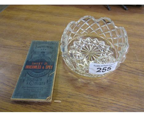
Lot 255
Sale Item: INVERNESS / SPEY MAP & CRYSTAL BOWL (AF) Vat Status: No Vat Buyers Premium: This lot is subject to a Buyers Premium of 15% + Vat @ 20% Additional Info : Lots purchased online with the-saleroom.com will attract an additional charge for this service in the sum of 3% of the hammer price plus VAT @ 20%


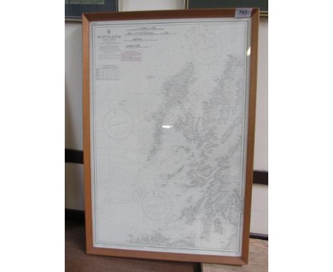
Lot 793
Sale Item: SCOTLAND WEST COAST MAP (AF) Vat Status: No Vat Buyers Premium: This lot is subject to a Buyers Premium of 15% + Vat @ 20% Additional Info : Lots purchased online with the-saleroom.com will attract an additional charge for this service in the sum of 3% of the hammer price plus VAT @ 20%


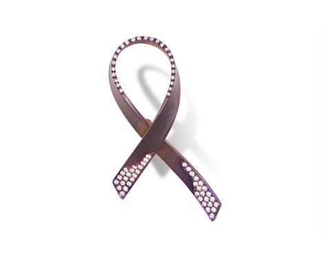
Lot 117
A DIAMOND AND TITANIUM RIBBON BROOCH, BY MARGHERITA BURGENERThe very light purplish-pink titanium crossover ribbon, accented to the front and back by round brilliant-cut diamonds, mounted in titanium, diamonds weighing 0.62ct total, signed and cased Margherita Burgener, 'Ribbon #1', length 5.6cmAll proceeds will be donated to the European Institute of Oncology based in MilanEmanuela Burgener founded ‘Ribbon for Hope’ in 2017 after her personal fight and recovery from breast cancer. The inspiration of the project is the symbol of the ribbon universally understood as the fight against cancer. Estée Lauder was the first to use the pink ribbon as the emblem of the fight against cancer which, today is seen in many different colours representing many different diseases.Ribbon for Hope is a handmade titanium and diamond brooch, as many of Margherita Burgener jewels.Twwwhis piece also embodies many concepts. Firstly, the ribbon is a message of hope in the advances of research and technology for the treatment of cancer. Secondly, it is a symbol that represents a large community of people in the fight against cancer including doctors, researchers, volunteers and patients. Finally and above all else, Ribbon for Hope is an important fundraising means for pivotal research that should never stop. Therefore, all the proceeds of Ribbon for Hope sales are entirely donated to the Institute of European Oncology Foundation based in Milan. The European Institute of Oncology (IEO) provides patient-centred care and guarantees patients access to innovative therapies and to early clinical trials. The SHARP research programme, a GPS in metastatic breast cancer is an achievement of the strategic interest in early clinical trials. SHARP aims to identify ‘breakdowns’ (genetic mutations) and map the routes that cancer cells take to invade other organs. Clinical data and biological samples from participating patients will allow experts to examine the DNA using the latest molecular screening techniques and devise an appropriate cancer treatment plan.(www.ieo.it - Doctor Curigliano)


Lot 186
French Dinky 32AB Panhard ‘SNCF’ articulated lorry, dark blue cab and trailer, tinplate tilt with SNCF and French map logo to sides, blue concave hubs, excellent to mint condition, slight factory paint bubble to cab roof, in yellow picture box, fair to good condition, some rubbing and creases, hole/tear to one picture side, pen mark to one end flap.


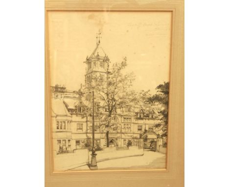
Lot 730
A pencil drawing of Cardiff Royal Infirmary signed top right, Marie Preis? dated 1933, 30 x 22cm together with an early 20th century black and white photograph of a mineral traffic locomotive on the Barry railway, inscribed to mount, R & W Hawthorn, Leslie & Co Ltd Engineers Newcastle-Upon-Tyne dated 1914, 25 x 37cm in oak frame, also together with a hand drawn map of South America inscribed drawn by Maria Edwards October 1878, Royal British Schools, Thames aged 11 years in carved oak Oxford type frame


Lot 885
Abraham Ortelius/Lorraine (Lotharingiae) 1587/Touraine (Turonensis) 1592/Anjou (Andegaben) 1579/Gallia 1590/Britanniae et Normandie 1594/Regionis Biturigum/six hand-coloured maps, 44.5cm x 55cm and another, Fessae et Marocchi Regna Africae Celeberr 1595/coloured map laid onto card, 40.5cm x 52.5cm


Lot 292
Original Normandy Invasion Aerial Photograph scale 1:25000 (3718 SE ) Covers area from Arromanches les Bains in the west to Bernieres sur Mer in the East, going as far inland as Creully. On reverse stunning aerial views just above shoreline with gun positions, houses and key references points shown, three sectional views. Linen backing marked, photographs in very good condition, tipped-in letter from Imperial War Museum describing coverage of map.


Lot 300
Two German Photograph Collections, The first Finland 1941. Interesting and well captioned collection providing a detailed account of the work of a bridge building unit in Finland. Of particular interest is the bridge "B-300" built at Kemijarvi in Lapland, which is illustrated stage by stage. A visit by Generaloberst V.Falkenhorst to the bridge and the unit is well illustrated. Other images show a Mark III tank being ferried over, air raid damage and other projects, supported by a slightly stained hand drawn map of the area NW of Oulu 103 photographs with pages laced together. The second a stapled photographic report of a bridge building unit part of Pioneer Regiment 4 illustrating the rebuilding of a railway bridge in 1941 at " Platy-Tschiflik" Bulgaria? very good images well captioned 36 photographs. The two collections/albums.

Lot 241
Great War Maps Belonging to Major-General W.H.Greenly. Interesting and in some cases important original maps used by General Greenly, who commanded the 2nd Cavalry Division. It was while in this command that Greenly was involved in the cavalry aspects of the planning of the great Tank attack at Cambrai with its expected breakthrough and one map shows all the bridges and crossing points from Havarincourt and to the West and North West of Cambrai marked in his hand with numbers and descriptions supported by a marginal key, the front of the map shows Greenly's signature. Various other maps show front lines and what appear to be objectives. Note Greenly was keen to take over a more active command than the cavalry and in the crisis of March 1918 took over the 14th Division under Gough only to be relieved having suffered something of a breakdown. 17 maps in all.


Lot 20
Body Map 1980s jersey mythical print red cotton dress, long oversized sleeves and irregular relaxed fit with open neck line. Size UK 10. Measuring 16 inches across bust and 42 inches length. Together with a Body Map Irregular shaped punk era t shirt. Measuring 19 inches across chest and 24 inches length, sleeves measure 30 inches from shoulder to cuff. 21.


-
108737 item(s)/page