We found 109198 price guide item(s) matching your search

Refine your search

Year

Filter by Price Range
  • List
  • Grid
  • 109198 item(s)
    /page

Lot 156

Christopher Weigel AFRICA VETUS Nuremburg, c.1720 Copperplate, hand coloured, number ‘XXVIII’ in upper left corner, ‘18’ in upper right corner; verso: map secured to window mount with masking tape at top and part sides, some paint show through, pencil number, two small damp marks in opposite margins, framed41 by 33cm

Lot 153

Jacques Nicolas Bellin COSTE OCCIDENTALE D’AFRIQUE Paris, 1757 Copperplate, hand coloured, ‘Afrique Occidentale No. 3’ in upper right corner, bottom right ‘Tome 3 in 80. Page 307’, bottom left ‘Tome I in 40. No. 16’, 1,5 cm oily spot in lower right corner, light toning with tanning behind window mount; verso: map secured to window mount with masking tape at top and part sides, 1cm closed tear perpendicular to centerfold repaired with masking tape, tanning behind window mount, pencil note in margin, white paper tape on centerfold, evenly tanned with some white foxing, framed 26,5 by 24,5cmLITERATURENorwich #321

Lot 147

Johann Matthias Christoph Reinecke CHARTE DER SÜDSPITZE AFRICA’S UND DER COLONIE VOM VORGEBIRGE DER GUTEN HOFFNUNG Weimar, 1804 Copperplate, hand coloured, light foxing with some darker spots; verso: map secured to window mount with masking tape at top and part sides, pencilled number on edge, some paint show through, framed59 by 39cm

Lot 148

Jan Barend Elwe L’AFRIQUE DIVESÉE EN SES EMPIRE ROYAUMES ET ETATS Amsterdam, MDCCXCII [1792] Copperplate, hand coloured, some foxing, corrected fold in left lower corner and along centerfold, tanning in margins, thin strip of paperloss at bottom 4 cm of centerfold; verso: map secured to window mount with masking tape at top and sides, pencil notes, centerfold repaired with tape for 15cm section at bottom with some deterioration of tape, some paperloss due to chips in bottom margin and one shallow triangular portion in right corner, two tears in bottom margin which one is 4cm long, top corners rounded from loss, brown paint show through, framed59 by 46cmLITERATURENorwich #109

Lot 154

Robert de Vaugondy L’AFRIQUE DIVISÉE EN SES PRINCIPALES PARTIES Paris, 1748 Copperplate, hand coloured, green tinged laid paper, ‘75’ in ink in upper right corner margin, 1,5 cm oily spot in lower right corner of map, brown line corresponding to window mount; verso: map secured to window mount with masking tape at top and sides, pencilled number, framed19 by 16cmLITERATURENorwich #90 (variation)

Lot 157

Johann Baptist Homaan TOTIUS AFRICAE NOVA REPRAESENTATIO QUA PRAETER DIVERSON IN EA STATUS ET REGIONES, ETIAM ORIGO NILI Nuremberg, [1715] Copperplate, hand coloured, foxing, some wrinkling along centerfold; verso: foxing, pencil notes, map secured to window mount with masking tape at top and part sides, paper tape in 4cm high T-shape to repair bottom of centerfold, tear in margin repaired with tape, small stamp, light paint show through, framed58 by 49cmLITERATURENorwich #72

Lot 143

Henry Teesdale AFRICA London, [1831] Copperplate, uncoloured, ‘33’ top and bottom right, pencil notes in central southern Africa, thin tan line corresponding to mounting window edge; verso: map secured to window mount with masking tape at top, centerfold ends, one bottom cornerand middle; remains of paper tape covering centerfold, ink number in bottom left corner, light paint show through, framed33,5 by 41cmLITERATURENorwich #133

Lot 151

Rigobert Bonne CARTE DU CANAL DE MOSAMBIQUE, CONTENANT L’ISLE DE MADAGASCAR AVEC LES CÔTES D’AFRIQUE, DEPUIS LE CAP DE BONNE ESPÉRANCE JUSQU À MELINDE Geneva, [1780] Copperplate, hand coloured, ‘Livre I, II, III, IV.’, ‘Andre sculp.’ bottom right, top right hand corner ‘No. 11’, 2,5cm wide tanned strip along centerfold, top left hand corner; verso: two parallel tears from top either side of centerfold repaired with 5cm tape, light tanning with white foxing, yellowed cellotape used to secure map to window mount, framed32 by 21,5cmLITERATURENorwich #173

Lot 163

BUNGEN KAIHO ON'EDO EZU (SCALED POCKET PLAN OF EDO) Suharaya, Mohē, 嘉永五 [Kaei5 –c.1852] Woodblock, hand coloured, two censorships stamps, wear along original folds, slight misalignment of extension, one foxing spot, hinged onto mount, framed86,5 by 57,5cm and extension 43,8 by 14,5cmPROVENANCEPurchased in Tokyo in 1960sA practical, yet decorative map of Edo (now Tokyo) just before the end of Japanese isolation. The map has no directional orientation and texts radiate from the centre. This is because the map is designed to be read on a low table or Tatami, allowing the reader to move around it while maintaining readability. Temples, shrines and Edo castle are illustrated on the map. The red dots with clan symbols (mon) surround the castle and indicate the houses of the elite and the ruling class. The large mon inside the castle precinct confirms that it was still occupied by the Tokugawa Shogunate when the map was produced. - L.R.Rotolo, P., Mapping social hierarchies onto the city of Edo, Osher Map Library: Smith Center for Cartographic Education, 2013 (http://www.oshermaps.org/exhibitions/ map-commentaries/social-hierarchies-edo)

Lot 161

Homann Erben [Homann Heirs] ABBILDLICHE GESCHICHTE DER AUSLÄNDISCHEN LAND THIERE I. BLAT, DARINNEN DIE ELEPHANTEN NACH IHREN FÜRNEHMSTEN VERRICHTUNGEN Nuremberg, 1746 Copperplate, hand coloured, some foxing and tanning; verso: map secured to window mount with masking tape at top and part sides, tanned, pencil notes, light paint show through, 1,5cm oily spot in lower left corner, some marks, framed57,5 by 49cmOne of three pedagogical broadsides of terrestrial animals by the German engravers and publishers Homann, the heirs of the famous Nuremberg cartographer Johann Baptist Homann (1664 - 1724). These broadsides were one of the first attempts to introduce accurate scientific depictions of ‘exotic’ animals to a Central Europeanaudience. - L.R.Nissen, C, Die Zoologische Buchillustration Ihre Bibliograhie und Geschichte Band I: Bibliographie, Stuttgard: Hierseman, 1974

Lot 162

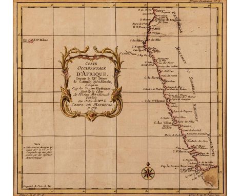
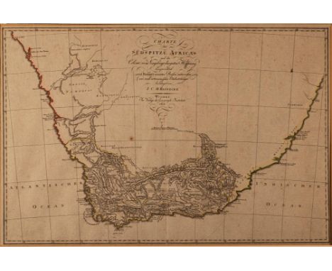
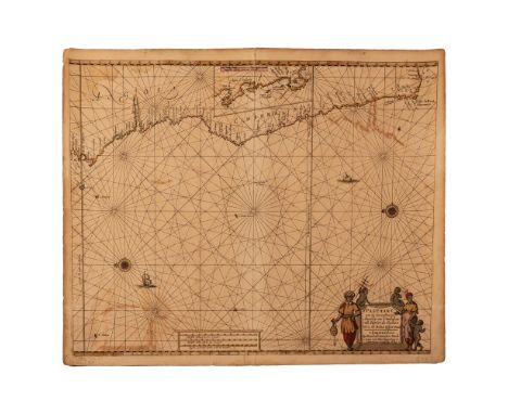
Hendrick Doncker TWO HENDRIK DONCKER CHARTS, 17TH CENTURY PASCAART VAN DE ZEE-CUSTEN VAN ANGOLA EN CIMBEBAS VAN RIVIER DE GALION TOT C. DE BONA ESPERANCAAmsterdam, 1659Copperplate, hand coloured, offsetting, pencil notes in bottom margin, 1cm tear in left margin, two small tears in bottom margin, top and bottom of centerfold opening in margin, some foxing; verso: 5cm tear repaired with tape, brown paint show through, 53,5 by 43cm; and PAS-CAERT VAN’T WESTELYCKSTE DEEL VAN OOST INDIEN EN DE EYLANDEN DAER ONDER BEGREPEN, VAN C. DE BONA ESPERANCA TOT C. COMORIN Amsterdam, c.1670Copperplate, hand coloured, one 5mm hole and two 2mm hole on left edge of map, penciled number in bottom margin, tanning on outer edge, some foxing, offsetting; verso: tanned, paint show through, white lines along top and bottom margins from previous framing, pencil note at top, 52 by 42cmExamples of maritime cartography from the Dutch Golden Age are rare. This was the age when the Dutch Republic was a major European trading power and dominated the oceans through the VOC (Vereenigde Oost-Indische Compagnie) and the WIC (West-Indische Compagnie). Not only trade flourished, but also art, science and a combination of the two, cartography. Of the cartographers and sea atlas publishers working in Amsterdam in the second half of the seventeenth century, Hendrik Doncker’s atlases were regarded as of particularly high quality. He was known to carefully and constantly revise his work and did not rely on previously published maps.The first Doncker chart shows the West Coast of Africa, from the Equator to the Cape of Good Hope and Cape Agulhas. It also includes an inset of the coast from St. Martin’s Bay (Velddrif/ Paternoster area) to the Cape of Good Hope. The map of the East Coast of Africa, in smaller scale, overlaps the other and the coastline starts at Monte dos Bramides, rounds southern Africa and continues up the coast to the Horn of Africa. It also includes Arabia, the Malabar Coast of India and Madagascar.Both maps use the Mercator projection with vertical meridians. The bar scales include Dutch, Spanish and French and English miles. The charts are crisscrossed with rhumb lines meeting at central points, with some adorned with compass roses. On the compass roses a fleur-de-lis points North and there is a Christian cross pointing East, denoting the position of Jerusalem in relation to Europe.The title of cartouche on the western chart is surrounded by depictions of the inhabitants of the area holding a sounding lead, a cross staff and a chart, all navigation tools of the period. Another decorative element on this chart is the depiction of Dutch East Indiamen sailing in the Atlantic. The eastern chart’s cartouche is decorated with a tortoise, lizards, snakes, and surmounted by an open winged bat. - L.R.Howse, Derek, The Sea Chart: An Historical Survey Based on the Collections in the National Maritime Museum, New York: McGraw-Hill, 1973

Lot 158

Pierre van der Aa LE CAP DE BONNE ESPERANCE SUIVANT LES NOUVELLES OBSERVATIONS DE MESSRS. DE L'ACADEMIE ROYALE DES SCIENCES Leiden, [1713] Copperplate, hand coloured, inked number ‘42’ in bottom right corner, no top margin, shifted strike in bottom left corner; verso: map secured to window mount with masking tape at top and sides, tanning lines from corrugated cardboard used in mounting, inked number in upper corner, some lighter toned areas, framed38 by 26cmLITERATURETooley p.3 Norwich 212

Lot 291

Moshekwa Langa ( -) ABSTRACT WITH TOPOGRAPHICAL MAP signed and dated 1996 on the reverse pencil, colour pencil and white correction fluid on paper 29,5 by 21cm

Lot 149

William Guthrie AFRICA, FROM THE BEST AUTHORITIES London, c.1790 Copperplate, hand coloured, ‘Dutch Ft’ at Table Bay, tanning along original fold lines, some foxing; verso: map secured to window mount and backing with double-sided tape on margin outside map frame, pencil numbers, small damp mark in lower left margin, tanning on edge, framed22,5 by 18,5cm

Lot 160

Matthäus Merian NOVA DESCRIPTIO AFRICAE Frankfurt, [1637] Copperplate, uncoloured, ‘11’ in upper right corner, overall tanning with lighter 2cm strip along fold line, a few foxing spots on map with darker spot center top, some white foxing in margin; verso: map secured to window mount with masking tape at top and part sides, linen strip on centerfold, tanned, framed35,5 by 27cmLITERATURETooley p.76, plate 57; Norwich #33

Lot 152

Tobias Conrad Lotter AFRICA, CONCINNATA SECUNDUM OBSERVATIONES MEMBROR Augsburg, [1760] Copperplate, hand coloured, some foxing, pencil note in bottom margin, 1,5 cm oily spot in southern Atlantic ocean, two small elongated holes in central Africa; verso: ‘149’ ink number in margin, map secured to window mount with masking tape at top, remains of paper strip along centerfold, small pigment spots, framed57 by 44cmLITERATURETooley p.70

Lot 159

Nicholas Visscher CARTE DE L'AFRIQUE MERIDIONALE OU PAYS ENTRE LA LIGNE & LE CAP DE BONNE ESPERANCE ET L'ISLE DE MADAGASCAR Amsterdam, [1710] Copperplate, hand coloured, ‘12’ in upper right corner, pencil notes in margin, two 2mm holes in interior of map, narrow tan line along edge of window mount; verso: ‘135’ in ink in top right corner, map secured to window mount with masking tape at top and part sides, pencil numbers and name on back, aged double sided tape along outside of margins, bottom 9cm of centerfold secured with masking tape, surface paperloss along the centerfold line, paint show through, framed58,5 by 51cmLITERATURETooley plate 89, Norwich #180

Lot 110

A late 18th/early 20th century map of Britain, with tables of the direct and cross roads, by I.V.Kircher, 60 x 100cm

Lot 61

Early 20th century Sheffield City map by L. R. Roberts & Co.

Lot 73

A framed print, map of the British Empire.

Lot 789

A Third Pattern FS fighting knife in sheath (elastic AF); an uncut pair of printed combined operations shoulder flashes; an Air Ministry printed sheet of five reconnaissance panoramic photographs of the Dutch coast headed “I.S.T.D for Force II” (folded and creased); 4 “Emergency Printing” maps of Arnham East, Arnhem West (2) and Renen (2), 1944 War Office map of Rotterdam, 1943 War Office map of Walcheren Amsterdam; an “Officer’s Aide Memoir” from HMS King Alfred (Brighton); three other booklets; and several wartime newspapers; all contained in a military map case. Basically GC (some of the maps and newspapers worn and discoloured) Note:These items were the property of the vendor’s father, who served in the Royal Marine Commandos

Lot 563

A Third Reich NSKK pressed aluminium plaque, 2½” x 3½”, depicting a motorist and motorcyclist looking at a map, NSKK eagle, legend “Markische Orientierungsfahrt Motorbrigade Berlin Brandenburg” and date 10.3.1935; an RAD armband with overlaid printed device (new condition); and 3 other items.

Lot 233

Boxed brass captain cabin map reader

Lot 1453

A framed map of England by Robert Morden 46cm x 40cm

Lot 1462

A collection of boat lithographs and a map

Lot 1650

An Early 20th century folding map. Walker’s Map of Geology Railways Roads Rivers and Canals.

Lot 513

A large, framed 'Royal Geographical Society Silver Map'.Approx 51x70cm

Lot 1460

A coloured map of Venice and two prints

Lot 845

A quantity of pictures and prints to include a framed map of Northamptonshire

Lot 504

An early 17th century "Breeches" Bible: The Bible: That is, The Holy Scriptures Conteined in the Old and New Testament, Translated according to the Ebrew and Greeke, and conferred with the best translations in others Languages... London, The deputies of Robert Barker, printer to the Queenes most excellent Maiestie, 1601, woodcut title page, in text woodcuts and map, leather bound, top board loose.Condition: Not collated

Lot 496

John Speede, a hand coloured map of Denbighshire, dated 1610, image 37cm x 50cm, mounted, framed and under glass.

Lot 494

A leather cased set of four fold-out motoring maps of England & Wales together with ten various Barthomews "Road Map of England & Wales", in remains of leather case, (2)

Lot 433

A hard stone map of the world, 63 x 97cm Condition Report: Available upon request

Lot 1187

A framed copy of Map of Wales after Johan Blaeu, printed by John Bartholemew

Lot 1186

A framed copy of Map of Worcestershire after Christopher Saxton

Lot 1132

An old John Cary Map 'A New Map of England' 1821, with original sleeve.

Lot 1180

An antique roller Map of the Holy Land before the formation of the State of Israel, a/f.

Lot 1131

An old Map, 'A new Map of the County of Hereford' corrected to 1827

Lot 1156

A Leatherman micra, folding penknife, map measure, Bill Mills lemonade bottle, pencil box etc.

Lot 1031

Assorted pictures and prints, to include county map of Essex, being a hand-coloured 18th century bookplate, later maps, pair of Willilam Wyllie prints etc

Lot 1037

W. Hollingsworth - Farmhouse in a landscape, oil on canvas, signed lower right, 40 x 60cm; together with a reproduction map print (2)

Lot 1029

Robert Morden - engraved county map of Suffolk, later hand coloured with the Hundreds, 36x42cm

Lot 81

A quantity of prints and engravings, including Batevia's Palace in the East Indies; Vue de la Riviere D'Endeavour; Baie de la Praya; Port du Roi Georges; Chinese merchants; Edinburgh; A bull tossing a dog; Cricket; Six chromolithographs of native scenes; A print after Redoute; A watercolour botanical study; A map dans la mer pacifique, all unframed, various sizes. (qty) CAB

Lot 241

A quantity of assorted pictures and prints, including; a hand coloured engraving of Stoke Bridge, Ipswich (from the collection of the late Sir John Mills); Lady Godiva; A map of Suffolk; and various chromolithographs and engravings. (qty) E1

Lot 273

Travel and Tourism posters, comprising; Picturing the South 1860- present, Exposition Nationale Suisse Lausane, 1964 High museum of art, Ski poster, 16-18th century costumes exhibition 2008, Island of Poros Greece, Bruges, Wonders of the Past tutankhamen, V&A power of the poster, Capitals of the common wealth, Aviators quick reference map, Swinbourne Railway, (a.f.), Alpes de France, (a.f.), The Famous London Transport Poster by E.Mcknight., (14). S4M

Lot 1459

Unknown artist; 'Finland Suomi' vintage tourism map/poster, 1949, lithograph in colours, 84cm x 47cm, rolled.

Lot 3326

James Bond paper ephemera, loose and in an album, including various sets of collectors cards, poster reproductions, photographs, Honor Blackman signed photograph with certificate, Ian Fleming Thriller map, limited edition Storyboard, postcards, newspapers etc Condition Report Click here for further images, condition, auction times & delivery costs

Lot 7484

A reproduction map of Nottinghamshire, framed and glazed, 35cm x 45cm

Lot 7044

A Robert Morden coloured map of Huntington Shire, framed and glazed, 37cm x 43cm

Lot 439

CRUCHLEY, (G.F.) - CRUCHLEY'S POSTAL MAP OF LONDON 1866, along with various vintage postcards and cards, along with a vintage bridge game card marker

Lot 1459

Sidney Hall, Map of England and Wales, approximately 49.5 x 38.5cm, published by Longman, Rees, Orme, Brown and green. Lyndon Jones 1980, fifteen black and white prints of WWII planes.

Lot 1360

Vintage Map Measures, barometer, plated cutlery, bottle stopper, cruet, napkin, rings, lighter, whistle, trinket pot, etc:- One Tray

Lot 339

The Railway Bell and Illustrated London Advertiser Map of London 1845 Published at 335 Strand Opposite Somerset House. This 19th Century Victorian paper railway map mounted on linen roll. Measures 71cm x 93cm.

Lot 481

A collection of assorted WWII Second World War (and related period) British Army uniform webbing. Including various belts, pouches, water canteen, map case and other items. 

Lot 532

An original WWI First World War folding Trench map of Le Sars, France. Map dated to 1916. The map showing trench lines throughout the region, bomb craters, and sites of interest etc . Linen backed, as issued. Measures approx; 66cm x 90cm. Rare period map.

Lot 511

An original WWI First World War folding Trench map of Zonnebeke, Belgium. Map dated to September 1917. The map showing trench lines throughout the region, many named The Paschendaele Terhand Line noted. Linen backed, as issued. Measures approx; 66cm x 90cm. Rare period map. 

Lot 344

A rare WWI First World War British Army issued Somme ' Trench Map '. Dated January 1917 the map shows an area of France, with the British trenches mapped for reference. ' Trenches Corrected To 1-1-17 ' to top. Some added pencil markings, presumed to be those marking bomb craters are also present. Linen backed as issued. Fragile - upper left section torn at seam, but still attached. Measures approx 68cm x 90cm when opened.

Lot 209

An original WWI First World War British issued Trench Map of Ypres, France. Dated 1916. Some hand annotations to border and hand drawn trenches in red. Linen backed (as issued) and in used, but physically complete condition. Rare.  

Lot 56

A rare original WWII Second World War RAF Royal Air Force dated silk escape map of Europe. Dated 1943, the map shows areas of Germany, Holland, Belgium and France to one side and a view of Germany to the other. Measures approx; 72cm x 72cm.

Lot 433

An original WWII Second World War Chindit silk ' escape and evade ' double sided map. The first side showing Siam, Malaya and Sumatra, and the other side showing an extended view of Siam and Sumatra. Rare period map. Measures approx; 63cm x 99cm. 

Loading...Loading...
  • 109198 item(s)
    /page

Recently Viewed Lots