We found 109182 price guide item(s) matching your search
There are 109182 lots that match your search criteria. Subscribe now to get instant access to the full price guide service.
Click here to subscribe- List
- Grid
-
109182 item(s)/page


Lot 280
A pair of 18th century needlework maps worked by Eliza Seccombe, 1775: one depicting Europe, Africa, Asia and New Holland with 'Northern', 'Eastern', 'Indian' and 'Southern' Oceans, the other of North and South America with 'Pacific or Oriental Ocean' and 'Western or Atlantic Ocean', both titled 'At Mrs Harvey's Marybone (sic) by Eliza Seccombe, 1775' and signed in ink 'E Seccombe' lower corners, framed and glazed, 33x36.5cm.*Notes- 'New Holland' was first applied to the Western Coast of Australia during the Golden Age of Dutch Exploration in 1644 by the Abel Tasman. The territory remained largely unexplored as it was considered too dry and infertile to support colonisation. In 1770 James Cook claimed the Western Coast of New Holland as British Territory and initially renamed it New Wales which was revised to New South Wales and officially recognised with the establishment of a settlement at Sydney in 1788. The term New Holland was often used to describe the unexplored eastern territories which is why the area is marked as 'Conjectural Coasts'. North Asia is also marked as ' Terra Incognita' for unexplored parts. The map of the Americas is interesting for the inclusion of both Hudson Bay and Baffin Bay in the period prior to the discovery of the Northwest Passage in 1850 by the McClure Arctic Expedition whilst searching for the lost Franklin Expedition of 1845.

Lot 79
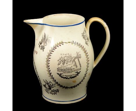
Large English creamware admiral Lord Nesleon commemorative jug, in black transfer with touches of colour highlights, with Nelson portrait, and 'Battle off Trefalgar' [sic] panels, named J Rogers below the spout, old restorations, 26cm.Condition report:Old restoration, no clearly discoloured to the crest of the handle, spout, and various areas to the baseline.Chipped glaze loss and flaking to the exterior, particularly behind where the handle joins the body at the top, rim, two filled patches to the side with map transfer, two areas affecting the portrait transfer, and heavy glaze flaking and loss to the interior.A horizontal hairline across the map transfer which can be seen on the interior as well as exterior.A shallow chip to the underside of the baseline, and another shallow chip elsewhere on the baseline which is underglaze.Fine crazing throughout.


Lot 126
Cook (James), River Thames and Mercury Bay in New Zealand, Bay of Islands in New Zealand, Tolaga Bay in New Zealand, seventeenth-century engraved map, hand-coloured, London: Strachan and Cadell, 27 x 43cm, framed and glazed, bearing Altea Gallery label to the reverse. Provenance: From Munstead Wood. The contents of the property are being sold by the former owners of the important country house which has now been purchased by the national trust. Munstead Wood is a Grade I listed house and gardens in Godalming Surrey. The garden was created by garden designer Gertrude Jekyll and became very well-known through her designs, and her books and articles in magazines such as Country Life. The Arts and Crafts style house was built for Jekyll and she lived there until 1932, Munstead Wood was designed by the architect Edwin Lutyens to compliment the garden with Jekylls influence on the original design. Munstead Wood was the first, and perhaps therefore the most important, collaboration between Jekyll and Lutyens in garden and house design. These collaborations number around 120, with other well-known examples including Deanery Garden in Berkshire and Hestercombe House in Somerset. Jekyll transformed the site over the years, first meeting Lutyens at Munstead Wood in 1889 when the collaboration began, and she lived there until her death in 1932. Prior to the sale to the National Trust, Munstead Wood was the vendors family home for more than 50 years, the owners over this time were Sir Robert Clark and Lady Clark who were responsible for the house and gardens regeneration to return it to its original concept.

Lot 125
Blaeu (Willen and Jan), 'Tabula Magellanica', seventeenth-century hand-coloured engraved map depicting South America, double-sided, with French text to the reverse, 40 x 53cm, framed and glazed. Provenance: From Munstead Wood. The contents of the property are being sold by the former owners of the important country house which has now been purchased by the national trust. Munstead Wood is a Grade I listed house and gardens in Godalming Surrey. The garden was created by garden designer Gertrude Jekyll and became very well-known through her designs, and her books and articles in magazines such as Country Life. The Arts and Crafts style house was built for Jekyll and she lived there until 1932, Munstead Wood was designed by the architect Edwin Lutyens to compliment the garden with Jekylls influence on the original design. Munstead Wood was the first, and perhaps therefore the most important, collaboration between Jekyll and Lutyens in garden and house design. These collaborations number around 120, with other well-known examples including Deanery Garden in Berkshire and Hestercombe House in Somerset. Jekyll transformed the site over the years, first meeting Lutyens at Munstead Wood in 1889 when the collaboration began, and she lived there until her death in 1932. Prior to the sale to the National Trust, Munstead Wood was the vendors family home for more than 50 years, the owners over this time were Sir Robert Clark and Lady Clark who were responsible for the house and gardens regeneration to return it to its original concept.


Lot 94
Australia Shaped Jig Map With Place Name Quiz by John Waddington Ltd 1970s outer box is slightly deformed Jig Saw puzzle is untested, good condition. All autographs are genuine hand signed and come with a Certificate of Authenticity. We combine postage on multiple winning lots and can ship worldwide. UK postage from £5.99, EU from £7.99, Rest of World from £10.

Lot 91
Scandinavia Shaped Jig Map With Place Name Quiz by John Waddington Ltd 1970s outer box is slightly deformed Jig Saw puzzle is untested, good condition. All autographs are genuine hand signed and come with a Certificate of Authenticity. We combine postage on multiple winning lots and can ship worldwide. UK postage from £5.99, EU from £7.99, Rest of World from £10.
Lot 12
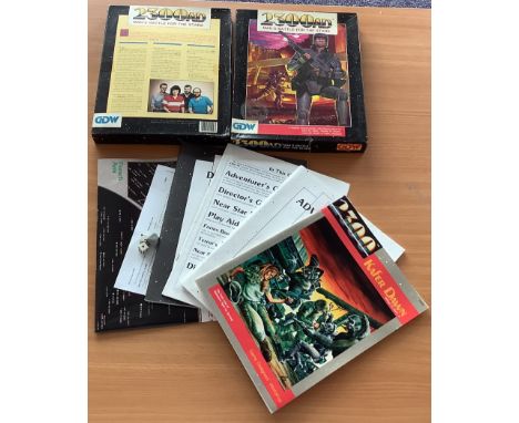
2300AD Man`s Battle for the stars 1988 Science fiction role playing game by Marc W Miller, Timothy B Brown, Lester W Smith, Frank Chadwick. Includes star map, 3 dice, Directors Guide, Instructions, Adventurers guide, Game designers workshop. Good Condition. Box Slightly damaged. All autographs are genuine hand signed and come with a Certificate of Authenticity. We combine postage on multiple winning lots and can ship worldwide. UK postage from £5.99, EU from £7.99, Rest of World from £10.

Lot 93
South Europe Shaped Jig Map With Place Name Quiz by John Waddington Ltd 1970s outer box is slightly deformed Jig Saw puzzle is untested, good condition. All autographs are genuine hand signed and come with a Certificate of Authenticity. We combine postage on multiple winning lots and can ship worldwide. UK postage from £5.99, EU from £7.99, Rest of World from £10.

Lot 92
North Europe Shaped Jig Map With Place Name Quiz by John Waddington Ltd 1970s outer box is slightly deformed Jig Saw puzzle is untested, good condition. All autographs are genuine hand signed and come with a Certificate of Authenticity. We combine postage on multiple winning lots and can ship worldwide. UK postage from £5.99, EU from £7.99, Rest of World from £10.


Lot 1235
Gefotografeerd en beschreven door Ellen Thorbecke. Photographed and depicted by Ellen Thorbecke. Met teekeningen van Schiff. The Hague, H.P. Leopold, 1937. (54) p. Incl. map. Orig. wr. 4to. Finely des. bilingual ed. Presented by the Java-China-Japan Lijn. Good copy. Added: (2) E. Thorbecke. Hong Kong. (Ills. Schiff). Shanghai, Hong Kong & Singapore, Kelly & Walsh, (1939). Sm. 4to. Half tone and col. ills. and dec. Orig. col. pictorial boards. Edges sl. worn. Fine copy. Dutch photogr. Ellen Thorbecke-Kolban (1902-73) was active in China from 1931 to 1941 (Leijerzapf 1999). (total 2)


Lot 1369
Ergebnisse seiner Reisen in den Jahren 1894, 1896-97 und 1898-1900. Leiden, E.J. Brill, 1904/ 1907. 2 vols. XV,(1),493,(2); XIII,(1),557,(2) p. Facsimile of large fold. map and many (fold.) (col.) plates. Orig. unif. gilt and dec. leather. 4to. Covers and spine sl. worn, occas. foxing. Good set. (total 2)

Lot 1901
Incl. a.o.: (1) A brochure for Algeria w. a cover des. after Pierre Collot. (2) Var. brochures for South Africa, ca. 1900-50, incl. a brochure des. by Noel Jinling and another advertising a travel route "Cape to Cairo". (3) 2 for Tunisia, incl. an ill. tourist map. (4) Several for Egypt. (5) Many for other North African countries. (total 38)

Lot 1902
for Belgium and Luxembourg. Early to mid 20th cent. Incl. a.o.: (1) 2 pamphlets for Ostende, Belgium, 1 that folds out into an ill. view of the beach, the other a tourist map of the coast. (2) A fold. pamphlet for Knocke-le-Zoute, Belgium. (3) A booklet advertising the history and the medicinal advantages of Spa, Belgium. (4) Var. brochures advertising tourist sites in Luxembourg. (total approx. 100)
Lot 1903
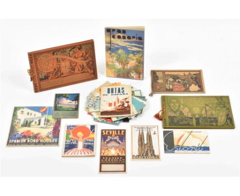
Early to mid 20th cent. Incl. a.o.: (1) 2 booklets advertising for Portugal's Costa do sol, 1 w. covers des. by "Luiza XXIX", the other publ. by the Sociedade Propaganda da Costa do sol. (2) A German booklet about Grand Canary Island w. fold. map. (3) A brochure w. map of the Spanish-American Exposition of 1929-30 w. a cover des. by Jimenez and w. a plan of the exposition. (4) A fold. tourist map of Lisbon. (5) A booklet advertising for "Spanish Road Houses. Run by the Spanish State Tourist Department". (total 25)
Lot 1904
Early to mid 20th cent. Incl. a.o.: (1) A brochure for the Côte d'Azur w. a cover after Roger Broders (stamp on front cover). (2) A brochure for Touquet w. covers des. by F. Commarmond (stamp on front cover). (3) A brochure for French beaches along the Mediterranean w. cover des. by Naurac. (4) A 1937 metro map of Paris. (5) Les Cinq Capitales, publ. by Société Kléos in 1929. (6) A brochure advertising different routes from Paris to South America. (total approx. 75)

Lot 1905
Ca. 1920-60. Incl. a.o.: (1) A German brochure about Milan w. fold. tourist map of the city. (2) A booklet of photos of Venice. (3) A booklet on Parma w. a sm. tourist map. (4) A pamphlet on Lake Como w. fold. map of the region. (5) A booklet on skiing in St. Moritz. (6) A fold. tourist map of Florence. (total approx. 100)


Lot 1907
for Norway, Sweden, Finland and Denmark. Ca. 1920-60. Incl. a.o.: (1) A German brochure for summer travel in Finland w. cover des. by Ingrid Bade. (2) A fold. tourist map of Oslo. (3) A fold. tourist map of Jutland. (4) A tourist map of Norway, 1936. (5) 10 sm. b/w photogr. of Copenhagen. (total 56)

Lot 1908
Ca. 1900-60. Incl. a.o.: (1) A brochure for Crikvenica. (2) A pamphlet on Dubrovnik. (3) A Dutch brochure on Hungary w. cover des. by Marianne Lechner. (4) A pamphlet on Shkodra in Albania. (5) A brochure on the healing properties of the St. Luke bath in Budapest. (6) A fold. tourist map of Budapest. (total 42)

Lot 1909
Early to mid 20th cent. Incl. a.o.: (1) A Travel & Leisure brochure on Canaima, Venezuela w. cover des. by Rombola. (2) A booklet on Montana (USA) publ. by the Montana State Highway Commission. (3) A booklet on the Cathedral of Commerce in New York, "The Highest Building in the World". (4) A fold. tourist map of the USA and Mexico (stamp on front cover). (5) A brochure on Cuba w. photogr. (6) A booklet advertising the Canadian National Railway system. (total 57)

Lot 1918
Ca. 1900-60. Incl. a.o.: (1) Breslau und Schlesiens Berge. Map in ill. cover by G. Wystrup, ca. 1935. (2) Rhein-Main Frankfurt, ca. 1950. (3) Führer duch Dresden und Umgebung Vereinigte Dresdner Rund-u. Gesellschaftsfahrten bis her Hofmanns Rundfahrten, ca. 1930. 36 p. (4) La Bavière sous la neige et le soleil, Allemagne, 1936 -and 86 similar brochures/ leaflets on the Alpes, Rhine-Moezel, and cities/ regions all over Germany. (total 90)

Lot 2059
Printed by C. Chevalier in Rott. for Verkoopassociatie ENCI-CEMY N.V. in Amst., n.d. (1938), 80 p., w. fold. map, num. (photogr.) ills., typography and photomontage comb-bound wr. by Paul Schuitema, 4to. Map foxed. Backwr. stained, frontwr. creased in corners. (2) Paul Schuitema. Waar Nederland trotsch op is. Hoe we tegen het water vochten en wat we ermee deden. Vol. 1. Leyden, A.W. Sijthoff, 1940, (51) p., (col.) photogr. and photomontage ills. by P. Schuitema, C. Oorthuys, E. Besnyö, E. Andriesse and P. Zwart, orig. clothbacked photomontage boards by Schuitema, 4to (minimal imperfections). -and 3 others, incl. a mediocre copy of the dustwrappers of Balans only. (total 5)

Lot 2233
1930s and 40s. (1) Abyssinië in vogelvlucht gezien, w. photos of the most important leaders of the time. Des. by W. H. Seghers. Antwerp, Patria N.V., 1935. 55 x 88 cm. (2) Wat Deutschland hebben wil. Large map of the countries Germany wanted to occupy. London, Stanford's Geographical Establishment, 1930s. 76 x 112 cm. (3) Informative 2-sided poster about the Indian army in 1945. London, Fosh and Cross LTD, (1951?). 76 x 100 cm. All fold., a few sm. tears, but in good condition. An interesting and unique set, rare. (total 3)

Lot 2437
zu dem Handbuch für specielle Eisenbahn-Technik (...). Leipzig, W. Engelmann, 1871. 2 vols. Num. double-p. plates. Cl. 8vo. -and the same work in 2 other eds. (2) Platen Waterbouwkunde XV. B. Spoorwegen. (s'Gravenhage, Van Cleef, 1899). Plate book of train des. Hcl. Sm. folio. (3) Hollandsche Ijzeren Spoorweg-Maatschappij 1839-1889. Amst., Ellerman, Harms & Co. 119 p. Num. fold. plates. Orig. ill. cl. Sm. folio. -and 1 other and a map, "Spoor- en tramwegkaart van Nederland", 1919. Books sl. worn, map fold. (total 8)

Lot 2782
Omdat mijn huis daar stond. 24 maart 1975. Een verslag in fotos van de gebeurtenissen die dag in de Amsterdamse Nieuwmarkt. 1st ed., 1975. (2) De Metro demonstratie en hoe't Gezag er 'n rel van maakte. Amst., Lont, 1975. 128 p. Cover soiled. (3) H. Nijman. Autocratie. De lastige Amsterdammer, 1972. (4) Geen Metro in de binnenstad. C. Jongens, M. Bierman, W.F. Heinemeyer. Photography by Aart Klein. Amst., Bezige Bij, 1968. Incl. Amring map. (5) Nieuwmarkt Nieuwskrant no. 1, 2, 5, 6 and 9, 1974. -and 10 more. (total 19)
Lot 350
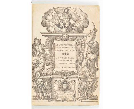
Venice, Gabriel Giolito de Ferrarie Fratel, 1553. 1st ed. (12),309,(1) p. Large 8vo. Rebound in green leather w. gilt title on spine. Title in woodcut historiated architectural border, 93 woodcut text ills. (some duplicates), historiated letters beginning each canto, half p. woodcut zonal world map incl. the Americas, last leaf w. printer's device, printed in italics in 2 columns. Rare, beautiful 1st ed. of Dolce's Italian transl. of Ovid's Metamorphoses in ottava rima. Ex libris G. Fumach upper pastedown. Sl. foxing/ staining, some early paper repairs throughout esp. last few pages, last p. w. printer's device sl. dam./ reinforced. Good condition.
Lot 358
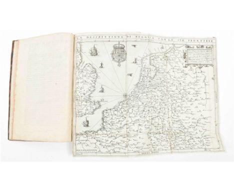
Autrement dict La Germanie Inferieure, ou Basse-Allemaigne. Lodovico Guicciardini (..) avec diverses cartes Geographiques dudit pais (..) Anvers. Guillaume Silvius, 1567. [1st French ed.] 4to., Leather, gilted title on spine. Rebound w. new endpapers, title w. vignette and typographic ornaments foll. by 2 other pages w. typographic ornaments, coat of arms and portrait of Philips II, (20),389 p. and index, folded gen. map, Brabant, Louvain, Brusselles, Anvers, Curia Antverpiana (washed copy), Bolduc, Malines, Hollande, Amsterdam, Flandres, Gendt, Brugae, Yprae, Hainault, Liege. Complete w. all maps and plans, mostly in woodcut. The Antwerp townhall was later inserted and originally not meant for this first French ed, Ref. Guicciardini Illustratus. Deys a.o. Utrecht. 2001. p. 30-31. New endpapers, title page w. name in ms., last pp w. water stains, ex-libris on last endpaper, binding w. a few scratches as usual. This 1st. Fr. ed. was preceded by an Italian ed., in the same year 1567.
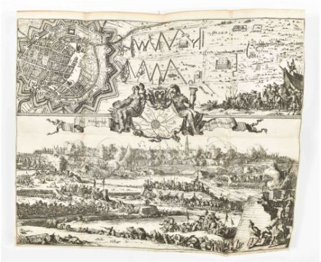
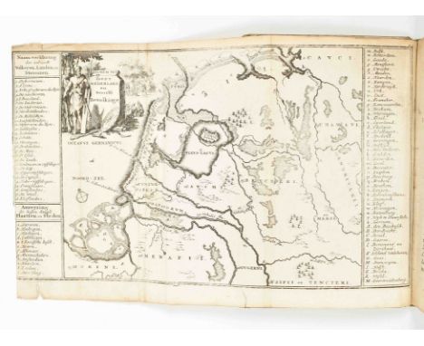
Lot 404
Door de Wapenen des Konings van Vrankryk, Dat is Een Waarachtigh Verhaal Van den Fransen, Engelsen, Keulsen, en Munstersen Oorlogh, Tegen de Vereenigde Nederlanden, Met desselfs Binnelandtse Beroerten. Amst., M.W. Doornik, 1674. (6),528,(22) p. engr., frontisp. and 6 large fold./ double-p. plates (incl. 1 map of United Provinces and 1 w. incorporated bird's eye plan of Groningen) by a.o. R. de Hooghe, 14 engr. portraits, contemp. calf, gilt and ribbed spine, sm. 4to. Owner's entry on upper flyleaf. Covers sl. worn, some waterst. along edges (not affecting text), foxing, and some plate folds worn. Overall in good condition. W. added chapter on the murder of the De Witt brothers bound between p. 344 and p. 345. A 2nd vol. was publ. in 1676, not present here.
Lot 435
Rott., Dirk Smits, 1750. (14),(38),(4),179,(3) p. Sm. 4to. Modern half linen. Ill. frontisp., ill. dedication and title-p. vignette by J. Punt, fold. portrait of Willem IV and full-p. portrait of the author by P. Tanjé after G. Sanders and D. à Nijmegen, 3 full-p. title engr. Lacks fold. map, spine and boards sl. dam.

Lot 441
Zynde d'eerste opkomst van Holland, Zeeland, 't Sticht Utrecht, Overyzel, Vriesland, Braband, Vlaanderen, enz. Amst., Gerrit Tielenburg, 1756. 5th ed. Sm. 8vo. Hcalf, ribbed spine w. marbled paper boards. Engr. allegorical title from the J. Goeree ed., fold. map, 17 full-p. engr. (2 fold.), 7 in-text engr. Binding sl. worn, mild foxing, endpapers sl. waterst. Good copy.
Lot 442
Amst., J. van Royen, 1701. 2nd ed. (16),224,(16) p. 16mo. Contemp. vellum w. manuscript title on spine. Engr. title, fold. map, 14 plates (many with 2 views), 6 in-text ills. Some marginalia upper flyleaf and lower pastedown. A few plates and pages with water stains, but overall in fair condition.
Lot 465
Staat- en aardrijkskundige beschrijving van het koningrijk der Nederlanden, of der XVII. Nederlandsche provincien, benevens het Groot-Hertogdom Luxemburg. Haarlem, heirs F. Bohn, 1827. 2nd ed. XVI,478 p. 8vo. Hcalf w. marbled paper boards and gilt title on spine. Handcol. fold. engr. map. Spine sl. worn. (2) Geschiedenis van de Fransche heerschappij in Europa. The Hague, J. Allart, 1815-23. 8 vols. 8vo. Hcalf w. marbled paper boards and gilt title on spine. Engr. frontisp. by R. Vinkeles after M.J. van Bree. Foxed. (3) Idem. Verkorte geschiedenis der Nederlanden (...). Haarlem, heirs F. Bohn, 1827. 2nd ed. 2 vols. 8vo. Hcalf w. marbled paper boards and gilt title on spine. 6 engr. plates and 3 large fold. letterpress charts. Excellent condition. -and 9 other titles by Van Kampen in 28 vols., all unif. bound. (total 39)

Lot 506
van veele en nooit meer gehoorde voorvallen, die geschiet zyn in verscheide harde winters, inzonderheid van den Jaare 1709 en 1740. Behelzende zeer veele aanmerkenswaardige zaken, die in de meeste gewesten van Europa en voornamentlyk in ons vaderland, door de felle koude gebeurt zyn (...). Amst., A van Huyssteen and S. van Esveldt, n.d. (1741), (6),100,(1) p., w. nice large fold. engr. skating-print, later boards, sm. 8vo. Plate with closed tear; with scattered owner's stamps of J. Hondius Hz. (1889). Large fold. leaf with related mounted newspaper clippings at the end. Warranted in pen by Van Esveldt. One more part was published. (2) H.J. van der Wijck. Aanmerkingen en bedenkingen (...) op de Proeve van een ontwerp tot sluiting van den rivier den Neder-Rhijn en Leck en het storten van derzelver water op den IJssel; gedrukt en uitgegeven te Nijmegen, bij de Wed. J.C. Vieweg en Zoon. 1821. Amst., P. den Hengst en Zoon, 1823, (4),127,(1) p., w. loosely inserted letterpress errata-leaf, contemp. boards, 4to. Paper over spine dam. Rare. (3) A.J. van der Aa. Beschrijving van den Krimpenrewaard [sic] en den Lopikerwaard. Schoonhoven, S.E. van Nooten, 1847, (8),83 p., w. fold. lithogr map, orig. printed wr., sm. 8vo (very good copy). -and 10 others, incl. 6 loose "bijlagen". (total 13)

Lot 509
en trouw, gedurende den Belgischen opstand. Haarlem, heirs F. Bohn, 1834, XL,640 p., w. engr. title and 2 fold. plates by W. Nieuwhoff after H.P. Oosterhuis, and large fold. engr. map w. handcol. outlines, contemp. (orig.?) hcl. w. paper letterpiece on spine. Sm. tear in map. Lower hinge partly splitting, spine browned and covers a bit stained/ foxed. (2) Hollands Leeuw ontwaakt. Tafereelen en herinneringen uit de dagen van den Belgischen opstand in 1830 (...). The Hague, J. Immerzeel Jr., 1831, VIII,490 p., w. engr. title by J.C. Bendorp, contemp. boards w. paper letterpiece on spine. Spine faded. Scarce/ rare. (3) G.K. van Hogendorp. Zeven stukjes ten vervolge op De scheiding van Holland en Belgie, uitgegeven in October, November en December 1830. The Hague, A. Kloots, 1830, 7 parts in 1 vol. each w. separate title-p. (partly 3rd eds.) and pagination, contemp. supple boards. Bookblock from spine. Rare collective edition. -and 1 other (1832). Added: 1 other by N.G. van Kampen (1841). (total 5)
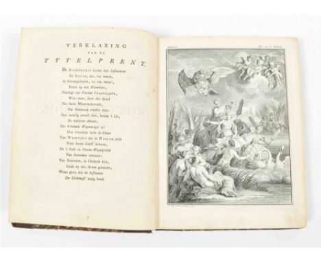
Lot 530
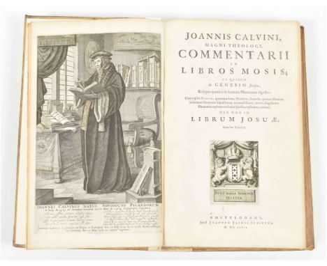
Editio omnium novissima (...). Amst., printed by Borrit Jansz. Smit for J.J. Schipper, 1667 (all 9 vols.) and widow J.J. Schipper, 1681 (the vol. w. the added general title-p.), 9 vols., each 1667 vol. w. engr. title-portrait (looking to the left or right), the vol. w. the series title w. woodcut title-vignette, a fine full-p. engr. portrait of Calvin in his study-room, a coat-of arms on the vol.-title and a map of the Middle-East on p. 12, contemp. panelled blindst. vellum, folio. Vols. 2-9 with cut-out owner's entry neatly closed w. paper strip; vol. 8 waterst. at the beginning. Occas. minor other internal imperfections. Vols. 1 and 6 rebacked and w. renewed endpapers, hinges of a few vols. are starting to split. This being the first 'modern' edition of Calvin's massive complete works, it remained the definite scholarly edition for two centuries, when the Strasbourg edition of Baum, Cunitz and Reuss appeared (1863-1900). Divided into nine volumes, the first seven contain his commentaries on the Bible, the eighth volume contains his theological works and the final volume with his Institutes and letters. With a collective titlepage in volume one, dated 1671 all other volumes with their own titlepages, dated 1667. (total 9)

Lot 532
tusschen den 14den en 15den Nov: MDCCLXXV (...). Amst., Wed. Loveringh en Allart, 1776. 2 vols. (xvi),245,(3); (viii),335 p. 8vo. Marbled paper wr. 2 engr. circular title-p. vignettes, engr. armorial vignette, 7 engr. fold. views by N. van de Meer after H. Kobell, 1 fold. map, 2 fold. plans (1 profile map w. 2 views), 1 fold. table, untrimmed and most quires (esp. vol. 2) uncut. Note on lower pastedown vol. 1. Paper over spine worn, some p. loosening, edges sl. browned. (total 2)
-
109182 item(s)/page