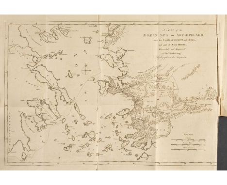

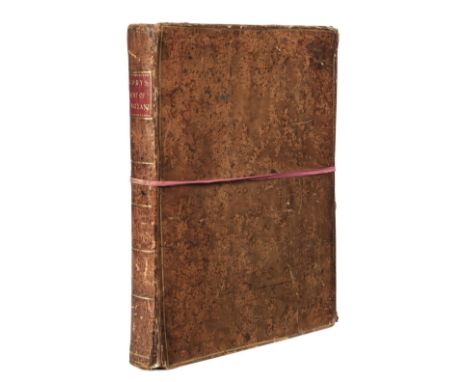
Chandler (Richard). Travels in Asia Minor: or an Account of a Tour made at the expense of the Society of Dilettanti, 1st edition, Oxford: Clarendon Press, 1775, folding engraved map by Thomas Kitchin, errata leaf, some damp stains and light spotting, contemporary mottled calf, rubbed with some worming and wear, 4to, together with Landor (A. Henry Savage). China and the Allies, 2 volumes, 1st edition, London: William Heinemann, 1901, colour and half-tone plates and illustrations, publisher's 32 pp. catalogue at end of volume I, occasional light spotting, pictorial endpapers, original yellow decorative cloth gilt, spines a little faded, a few small stains to volume I, 8vo, with 3 others including A. Henry Savage Landor's Tibet & Nepal Painted and Described, 1905 (spine faded with stains, small wormholes) and Josef Melnik's Russen Uber Russland. Ein Sammelwerk, Frankfurt, 1906Qty: (6)NOTESFirst work Atabey 215; Blackmer 318.
We found 109198 price guide item(s) matching your search
There are 109198 lots that match your search criteria. Subscribe now to get instant access to the full price guide service.
Click here to subscribe- List
- Grid
-
109198 item(s)/page
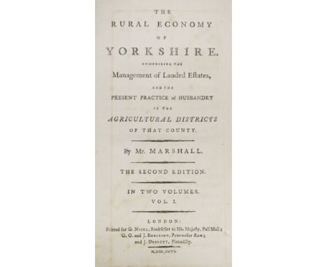
Marshall (William). The Rural Economy of Yorkshire, 2 volumes, 2nd edition, London: G. Nicol, G.G. & J. Robinson and J. Bebrett, 1796, folding & double-page engraved maps (both with short closed tear at foot of fold), light worm trail to lower margin at foot of first map and few worm holes/trail to last few leaves of volume 1, contemporary half calf, morocco title labels, 8voQty: (2)
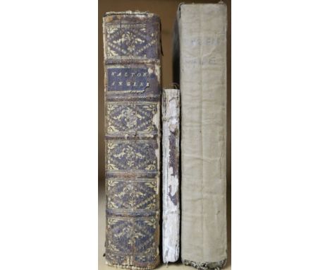
Walton (Isaac & Cotton, Charles). The Complete Angler: or, Contemplative Man's Recreation. Being a Discourse on Rivers, Fish-ponds, Fish, and Fishing. In Two Parts..., to which are prefixed, The Lives of the Authors. And Notes Historical, Critical, and Explanatory, by Sir John Hawkins, 3rd edition, London: John and Francis Rivington, & T. Caslon, 1775, engraved frontispiece and portrait frontispiece to second part, 14 engraved plates (including two of music, one misbound upside down), wood engraved illustrations of fish, contemporary calf, gilt decorated spine, insect damage to upper board and spine near joint, worn, 8vo, together with: Cole (Ralph), The Young Angler's Pocket Companion; or, a New and Complete Treatise on the Art of Angling, as may be practised with success in every River in England; during both the Winter and Summer Seasons..., London: R. Bassam, Symonds, Scatcherd & Whitaker, et al., 1795, 108 pp., engraved frontispiece (cropped at head), two engraved plates of fish, contemporary sheep-backed marbled boards, spine and boards worn with loss of leather and marbled sides, 12mo, plus: Salter (Thomas Frederick), The Angler's Guide, Being a Plain & Complete Practical Treatise on the Art of Angling for Sea, River, and Pond Fish, 8th edition, London: John Wicksteed, 1833, engraved portrait frontispiece and engraved title, six wood engraved plates, one folding wood engraved map, vignette illustrations, scattered spotting, upper hinge torn, original printed boards (browned), paper tape to spine, 8voQty: (3)

Buckinghamshire. Jefferies (Thomas), The County of Buckingham surveyed in MDCCLXVI, VII and VIII, 1st edition, March 24th, 1770, large scale engraved map on four conjoined sheets, with sparse contemporary outline colouring, decorative cartouche incorporating a view of Eton College, inset map of the town of Buckingham, laid on later linen, toned overall, several marginal repaired closed tears, 1295 x 840 mmQty: (1)

California. Santa Cruz, 1988, colour photographic pictorial map of Santa Cruz, illustrating hundreds of local businesses and caricatures of individual proprietors, 585 x 885 mmQty: (1)NOTESA clever map combining advertising and promotion for Santa Cruz and its individual businesses as well as illustrating the civic and entrepreneurial pride in the city.

* Cambridge. Lee (Kerry), Cambridge, " This immense & glorious work of fine intelligence...," Pictorial Maps Ltd., circa 1946, colour printed decorative map, 440 x 585 mm, framed and glazedQty: (1)NOTESThis whimsical and semi allegorical map has a charming self-portrait of the artist Kerry Lee. He can be seen in the lower right corner, his name signed on a piece of paper with his faithful dog, Jim sitting by his side. Kerry Lee produced two colour pictorial maps for British Railways in the 1930s which were revised up until the 1950s. These railway posters are very much in the style of Macdonald Gill.
Cary (John). Cary's New Map of England and Wales, with part of Scotland, on which are carefully laid down all the Direct and Principal Cross Roads, the Course of the Rivers and Navigable Canals..., 1st edition, 1794, printed title and dedication, engraved reticulated map of England and Wales with contemporary hand colouring, table of explanation and 76 (complete) engraved map sheets (numbered 1 - 81 and omitting 62/63, 71/72 & 80 as intended), all with contemporary outline colouring, two maps with small ink stains, index and list of subscribers bound at rear, near-contemporary ink manuscript ownership signature to verso of title, contemporary tree-calf gilt, bound 'envelope style' with linen ties, worn and frayed along the front edge of the binding, overall size 330 x 260 mmQty: (1)
![* Devon. Blaeu (Johannes), Devonia vulgo Devon-Shire, Amsterdam, [1645 or later], engraved map with contemporary outline colo](https://cdn.globalauctionplatform.com/2206a016-3da5-4a0b-9e5e-acbe010b0ffe/1de82316-3b1e-487d-969a-acc400e0e67f/468x382.jpg)

England & Wales. Carington Bowles (publisher), Bowles's New and Accurate Map of England and Wales; Comprehending all the Cities, Boroughs, markets and Sea-Port Towns, Villages, Lakes, Rivers, Forests, Ruins and Principal Seats of the Nobility; with the Roads described by Daniel Paterson..., 2nd Jany. 1782, large engraved map with bright contemporary hand colouring, sectionalised and laid on linen, large allegorical cartouche, table of explanation and compass rose, inset map of the Isles of Scilly, 1310 x 1030 mmQty: (1)

Estate plan. Messrs. Knight Frank & Rutley Publishers), Plan of the Moor Park Estate, Hertfordshire & Middlesex, for sale by Auction, 1919, large photolithographic estate plan with contemporary hand colouring, created for the auction sale of Moor Park, old folds, slight creasing, 920 x 1390 mmQty: (1)NOTESMoor Park was originally an area of Ruislip Moor, located in the ancient parish of Rickmansworth, on the boundary of Ruislip. The house and part of the grounds are now occupied by Moor Park Golf Club. Moor Park was originally a country house originally built in 1678–9 for James, Duke of Monmouth, reconstructed in the Palladian style circa 1720 by Giacomo Leoni. The area shown on the map extends from Rickmansworth (shown in detail) and Watford down to Northwood, including Sandy Lodge, to which Merchant Taylors School would later move in 1933.

Europe. Munster (Sebastian), Tabula Nova Prima Europa, Basel, circa 1550, hand-coloured woodblock map of Europe orientated to the south with a large galleon in the Atlantic ocean, central fold strengthened and repaired on verso, one repaired small hole in the central fold, slight creasing, some repaired marginal closed tears, slight tape, watercolour and mount staining, 275 x 345 mm, Latin text within an ornate woodcut border on verso, woodcut border with crude later colouringQty: (1)

* Gloucestershire & Monmouthshire. Jansson (Jan), Glocestria Ducatus cum Monumethensi Comitatu Glocester Shire & Monmouthshire, Amsterdam, circa 1650, engraved map with contemporary outline colouring, decorative cartouche and mileage scale, slight soiling, partial split to central fold, 405 x 510 mm, mounted, framed and glazedQty: (1)

* Hertfordshire. Blaeu (Johannes), Hertfordia comitatus vernacule Hertfordshire, Amsterdam, circa 1648, engraved map with contemporary outline colouring, decorative cartouche and mileage scale, central fold partially strengthened on verso, 385 x 500 mm, French text on verso, mounted, framed and double glazedQty: (1)

Holy Land. Munster (Sebastian), Das Heilig Judisch Landt mit Ausztheilung der Zwolff Geschlechter, Basel, circa 1580, uncoloured woodblock map, orinetated to the west, 270 x 345 mm, German text on verso within a decorative topographical borderQty: (1)NOTESPublished in the 'Cosmographia'. Laor E. 526.

Ireland. Ordnance Survey. A collection of seven Townland Surveys of Irish Counties: - Tipperary, Clare, Waterford, Wicklow, Armagh, Longford [and] Mayo, 1843, together seven uncoloured engraved reticulated county maps, each with a key plate and a statistical table of the parish and town data, each map with an unobtrusive Ordnance Survey blind stamp to the upper margin, each approximately 660 x 960 mmQty: (7)

Leicestershire. Speed (John), Leicester both Countye and Citie described, The Honorable Famylies that have had the titles of earls thereof. With other accidents therein observed, John Sudbury and George Humble, printed by Thomas Snodham, 1615, hand coloured engraved map, inset town plan of Leicesterold folds, cracked and split along folds with wear and slight loss to the printed surface where old folds cross, extensively restored and strengthened on verso, on four conjoined sheets with the descriptive text affixed to vertical and lower horizontal margins, torn with slight loss to margins but not affecting printed text, slight water and dust staining, overall size 485 x 645 mmQty: (1)NOTESAn unusual variant of a John Speed map, displayed as a 'broadsheet, with the descriptive text conjoined to the margins of the map rather than being printed on the verso.


London. Sampson Low, Marston & Co. Ltd (publishers). The "District Railway" Map of London, 6th edition, circa 1897, colour lithographic map, sectionalised and laid on linen, inset map of the Putney & Wimbleton Section, slight staining to margins, 660 x 1040 mm, publisher's decorative printed card wrappers, frayed and worn with spine partially lacking, folded size185 x 140 mmQty: (1)
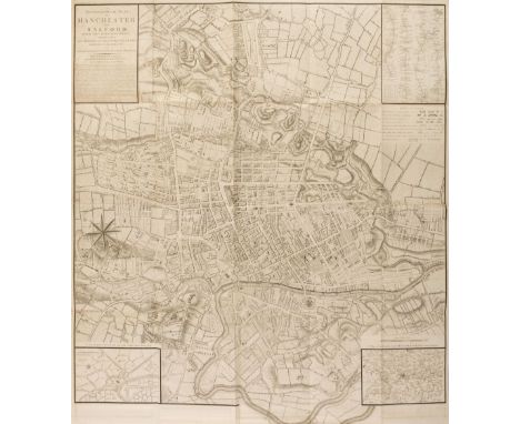
Manchester. Laurent (C.). A Topographical Plan of Manchester and Salford with the adjacent parts; shewing also the different allotments of land proposed to be built on as communicated to the Surveyor by the respective Proprietors..., Dec. 9th 1793, large uncoloured folding map, inset strip road map of the route from Manchester to London, inset plan of Manchester and Salford and an inset map of the Country around Manchester, old folds, very slight staining, 990 x 920 mmQty: (1)NOTESThe map was used to illustrate Aikin's 'Description of the Country from Thirty to Forty Miles Round Manchester'.
Map reference books. A mixed collection of approximately 200 books, pamphlets and dealers catalogues, 20th century, numerous map reference books, dealers catalogues, academic papers and pamphlets, including examples by Tooley, Holloway, Baynton-Williams, Kentish, Upcott, Harvey, Radford, Koeman, Fisher, Brooke-Hitching and Blake, various sizes, good/very goodQty: (approx. 200)
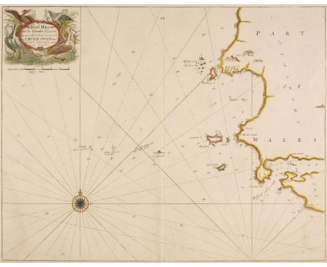
Maps. Collins (Capt. Greenville), Milford Haven and the Islands adjacent..., circa 1700, hand-coloured engraved chart, decorative cartouche, compass rose and numerous rhumb lines, 450 x 565 mm, mounted, together with Bowen (Emanuel). An Accurate Map of the County Palatine of Chester Divided into its Hundreds..., T. & J. Bowles, J. Tinney & Robt. Sayer, circa 1760, engraved map with contemporary outline colouring and some later enhancement, toned overall with staining to central fold, 535 x 695 mm, mounted, with Rapkin (J.). Birmingham, circa 1850, hand coloured decorative city plan, 365 x 500 mm, mountedQty: (3)
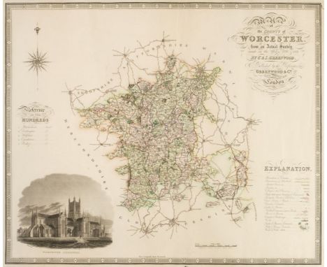
Maps. Greenwood (C. & J.), Map of the County of Worcester from an actual survey..., Map of the County of Huntingdon from an actual survey..., Map of the County of Northampton from an actual survey..., Map of the County of Stafford from an actual survey..., [and] Map of the County of Leicester from an actual survey..., circa 1830, together five engraved maps with contemporary hand colouring, each with an uncoloured topographical vignette, some marginal fraying and closed tears, occasional holes to the printed image, Staffordshire with long repaired closed tear affecting image, occasional spotting, each approximately 595 x 725 mm, together with Toms (W. engraver). Most Humbly Inscribed to the Rt. Honble. Sir Charles Wager, first Lord Commissioner of the Admiralty. This plan of the Harbour, Town and Several Forts O Cartagena. In which is Exhibited a Perfect View of the English Fleet as they Anchored all along the Coast..., S. Harding & W. H. Toms, May 29th 1741, uncoloured engraved map with reference table below image, creased and with some dust and finger soiling, 440 x 595 mm, with Faden (William, publisher). Plan of the Harbour of Cadiz surveyed by Brigadier Don Vincent Tofino de San Miguel Director of the Naval Academies for Cadets 1789, Re-published...., 1805, uncoloured engraved chart, inset reference table, creased and with some dust soiling and staining, 590 x 860 mm, plus Foster (E. publisher). Foster's Chart of Rome, France and Britain with Historical Notices and dates of other States of Europe, 43rd edition, circa 1855, an uncoloured broadside of chronological historical and important dates for Rome France and the countries of the United Kingdom, some staining, laid on linen, 800 x 565 mm, and three various Ordnance Survey maps, various sizes, all damagedQty: (11)NOTESSold as a collection of maps, not subject to return.

Ogilby (John). The Road from London to Rye in com. Sussex, The Road from London to Hith in com. Kent including the Road by Maidstone [and] The Road from London to Newhaven com. Sussex, circa 1676, together three hand-coloured engraved strip road maps, all commencing at London, some creasing to the second map, each approximately 300 x 450 mmQty: (3)NOTESSheet numbers: 31, 20 & 29.
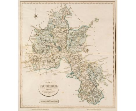
Oxfordshire. Cary (John), A New Map of Oxfordshire Divided into Hundreds exhibiting its Roads, Rivers Parks &c. Feby. 1st. 1821, engraved map with contemporary hand colouring, slight creasing, two rust spots, slight mount staining, 555 x 485 mm,Qty: (1)NOTESThe noted cartographer, engraver and publisher John Cary (1755-1835) collaborated with William Smith, 'the father of English geology', on a number of his geological projects, notably the 1815 Map and geological sections (1817-1819). Cary had previously produced large, topographical county maps for his New and Correct English Atlas and the plates which were being prepared for a new edition were instead adapted to accommodate Smith's detailed geology, the first set of geological maps being issued in 1819. This is a later state which has the engraved annotations identifying the various rock strata to be found within the county but lacks the hand colouring which identifies the geological variations. A note below the map states 'Geological section from London to Snowdon through this County by W.Smith - may be had of the Publisher, J. Cary, 181 Strand Pr. 7s.' Scarce.
Pigot (& Co. publishers). Pigot & Co's Maps of the Counties of Derby, Hereford, Lincoln, Leicester and Rutland, Monmouth, Nottingham, Salop, Stafford, Warwick and Worcester; with a General Map of Wales: being an Appendage to the Midland County Volume of their National and Commercial Directories, circa 1828, ten engraved maps with bright contemporary outline colouring, the map of Wales folding and with slight offsetting and staining, each map approximately 365 x 240 mm, map of Wales 680 x 535 mm, publisher's printed paper wrappers with title to upper siding, creased and dust-soiled, together with Bartholomews (John & Co., publishers). Thirty regional maps of England and Wales, circa 1900, colour lithographic regional maps, each approximately 345 x 435 mm, with 14 folding maps, including touring and Ordnance Survey maps of British counties and regions, including London and overseas maps of the Balkan peninsula, Sweden and Norway, Egypt and the Rhine and Danube Basins, various sizes and conditionQty: (approx.45)

Poland. Merian (Matthaus). Polonia Regnum et Silesia Ducatus, circa 1638, hand-coloured engraved map, 275 x 360 mm, together with another uncoloured copy from a slightly later edition, circa 1650, slight staining, 275 x 360 mmQty: (2)NOTESOriginally published in Merian's 'Nieuwe Archontologica Cosmica'.
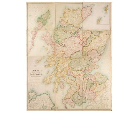
Scotland. Bartholomew (John), Black's New Large Map of Scotland, Compiled from The Ordnance, Admiralty & other Surveys, A & C Balck, Edinburgh, circa 1874, large engraved map with bright contemporary outline colouring, sectionalised and laid on linen, inset map of the Orkney and Shetland Islands, 1815 x 1425 mm, card endpapers, contained in a contemporary cloth slipcase with gilt title to upper cover, margins of slipcase crudely strengthened with tape, some staining, slipcase size overall 545 x 500 mmQty: (1)

Venice. Unattributed large scale map, 7 sheets (of 10?), circa 1860, large scale uncoloured engraved map on seven sheets numbered 1 - 5, 7 & 10, sectionalised and laid on linen, heavily stained, each sheet approximately 910 x 610 mm, contained in a contemporary marbled paper chemise, heavily worn and frayedQty: (7)NOTESSold as a collection of maps, not subject to return.

Warwickshire. Speed (John), The Counti of Warwick, The Shire Towne and Citie of Coventre described, Thomas Bassett & Richard Chiswell, [1676], hand-coloured engraved map, some later marginalia and ink annotations, toned overall, slight spotting, central fold partially split and creased, some marginal closed tears, 385 x 510 mm, English text on verso, together with The Society for the Diffusion of Useful Knowledge (publishers). Six Maps of the Stars, printed by Baldwin and Cradock, 1831, six (complete) engraved celestial maps with contemporary hand colouring, some spotting and dust soiling, retaining upper paper wrapper and sheet of explanation, lacking rear cover, disbound, overall size 400 x 340 mmQty: (7)


A group of Japanese Manga artwork and posters, including a Masamune Shirow "Steam Angel" print, two mounted "Steam Detectives" prints, a folder of G-Taste artwork, limited edition Indiana Jones and Aliens v Predator prints, a Species II hologram, a limited edition Earl Moran print of Marilyn, another signed print of posing girl, and three Star Wars Attack of the Clones billboards. Also included is a limited edition Vampirella "Back from the Grave" print and laminated Manhattan New York media map.


![[MISCELLANEOUS]. ILLUSTRATED Musson, Spencer. Sicily, Black, London, 1911, decorative grey-green cloth, top edges gilt, fort](https://cdn.globalauctionplatform.com/b0044162-cc17-430e-b1dc-ac9900d6b23a/a14da09d-4bd8-4f48-9821-ac9b01128208/468x382.jpg)
[MISCELLANEOUS]. ILLUSTRATED Musson, Spencer. Sicily, Black, London, 1911, decorative grey-green cloth, top edges gilt, forty-eight tipped-in colour plate illustrations by Alberto Pisa (including frontispiece, as called for), sketch map at end, quarto; and four other works, including two of Indian interest, (5).
![[MAP]. GREAT BRITAIN (SOUTHERN) Bellin, Jacques-Nicolas (1703-1772), 'Carte reduite des Isles Britanniques en cinq feuilles,](https://cdn.globalauctionplatform.com/b0044162-cc17-430e-b1dc-ac9900d6b23a/6a0e37e3-86fe-428e-8fb3-ac9b01128506/468x382.jpg)


-
109198 item(s)/page