We found 109182 price guide item(s) matching your search

Refine your search

Year

Filter by Price Range
  • List
  • Grid
  • 109182 item(s)
    /page

Lot 212

Framed map print of Yorkshire

Lot 53

Small framed map of Yorkshire by John Cary

Lot 311

The Estate of France, taken from the Memoirs of Le Comte De Boulain Villiers, published by T Wood & S Palmer, 1727 CONDITION REPORT: Lot 311 - binding distressed and cover worn, book cover detached, watermarks, spats and folds etc to pages, 1 volume with 387 pages, no map present.

Lot 708

A horn beaker, a poker ware cup holder, two inkwells, a blood letting fleam, compact, map marker and Stadium voltmeter

Lot 45

A late 17thC Robert Morden coloured county map 'Buckinghamshire' with a decorative title cartouche, sold by Abele Swale Awnfham & John Churchil 15.5'' x 13.5'' in a glazed frame

Lot 268

Rio de Janerio. Plan de la Baye et du Port de Rio-Janeiro, verifie par l'Auteur en 1751 hand coloured engraved map 52 x 35cm

Lot 270

Jan Blaeu Cantabrigiensis Comitatus, Cambridgeshire hand coloured engraved map Latin text verso 42 x 52cm (16 x 20in)

Lot 272

Saxton and Kip Cambridge Comitatus quem olim Iceni Insederunt 17th century hand coloured engraved map 29 x 33cm 29 x 33cm (11 x 13in)

Lot 273

Willem Janszoon Blaeu Granata Et Murcia Regna 17th century hand coloured map 38 x 50cm (15 x 20in)

Lot 274

John Senex, Ireland Corrected from the Latest Observations with inset map of the British Isles hand coloured engraved map, 18th century 98 x 66cm (38 x 26in)

Lot 275

Jan Blaeu Nortfolcia; Norfolke hand coloured engraved map, 17th century, with Latin text verso 52 x 61½cm (20 x 24in)

Lot 276

Two reduced size county road maps of Essex and Westmorland, 18th century hand coloured engravings, each 18.5 x 11.5cm; together with a 19th century map of Suffolk by Pigot 23 x 35cm (3)

Lot 278

C & J Greenwood Map of the County of Hertford; Map of the County of Buckingham hand coloured stipple engravings by J & C Walker, 1834, 61 x 70cm, and 63 x 77cm (sheet) (2)

Lot 280

John Speed Wight Island hand coloured engraved map published by Sudbury and Humble; with C.Smith dissected map of Devon, 2nd edition 1808, 46 x 50cm (2) 43 x 55cm (17 x 21in)

Lot 281

Nicolas Sanson, Anciens Royaumes de Kent, d'Essex et de Sussex hand coloured engraving, 1654 45 x 57cm (sheet); with a reproduction map of Suffolk after Speed (2)

Lot 282

Jan Jansson Norfolciae Descriptio; the Description of Norfolk hand coloured engraved map, some damage and slight losses 38 x 49cm; with S & N Buck South West Prospect of Yarmouth in the County of Norfolk engraving, browned, 32 x 85cm (2)

Lot 283

Jan Jansson A general Plott and description of the Fennes and surrounded grounds hand coloured engraved map, 17th century 43 x 55cm (17 x 21in)

Lot 285

John Speede Hartfordshire Described hand coloured engraved map published by Sudbury & Humble c.1610, English text verso 39 x 51cm (15 x 20in)

Lot 287

John Speed Hantshire described and devided hand coloured engraved map, English text verso published by Bassett & Chiswell 1676 39½ x 52cm (15 x 20in)

Lot 289

John Speed Hartfordshire described hand coloured engraved map framed to borders 38 x 50½cm (15 x 20in)

Lot 290

John Norden and William Hole Hamshire olim pars Belgarum, hand coloured engraved map, 1607 or later slight loss to lower centre 30 x 32cm (12 x 12in)

Lot 291

John Norden and John Speed Sussex described and divided hand coloured engraved map circa 1611 English text verso 39 x 51cm (15 x 20in)

Lot 293

Atlas. Ewing's New General Atlas, new edition by Hugh Murray, Edinburgh c.1840, 4to, 28 hand coloured maps including double page world map, boards detached

Lot 294

VAUGONDY (Robert de) Nouvel Atlas Portatif destine principalement pour l'instruction de la Jeunesse, Paris: Delamarche c.1806, 4to, engraved title, 53 double page maps with outline hand colour, folding map of France, some foxing and staining, worn binding

Lot 295

Atlas. BARTHELEMY. Voyage du Jeune Anacharsis en Grece, Paris 1822, oblong 8vo, 39 plates including folding hand coloured world map, outline colour to most other maps, half calf (rubbed)

Lot 297

Travel Maps. Stanford (Edward) Stanford's Map of the County of London, According to the Local Government Act, 1888, colour-coded to show electoral divisions and sanitary districts, lithographed map with original hand-colouring 1899, over-printed with boundaries and district titles, 680 x 1025mm., dissected and linen-backed; Bacon's New Map of Epping Forest, c.1900, 58.5 x 27cm; together with Baedeker's London and its Environs, 1911, and eight other Baedeker Guides including Italy, and a Murray's Handbook for Egypt and the Sudan, 1911

Lot 305

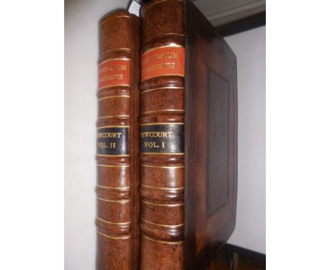
NEWCOURT (Richard) Repertorium Ecclesiasticum Parochiale Londiniense, An ecclesiastical parochial history of the diocese of London, 2 vols. first edition London 1708-10, folio, vol. I with portrait, 3 double-page plates and 1 single-page plate, vol. II with map of London, complete as collated, recent panel full calf

Lot 316

Prayer Book and Bible, London: Charles Bill and Executrix of Thomas Newcomb, 1711, folio, Bible with added engraved general title dated 1708, folding maps of the world and Holy Land, 'Forty Years Travels' plate, Jerusalem plan, Canaan map inserted before Matthew, Travels of St Paul plate, NT title dated 1707 with family births written overleaf, Apocrypha present, Psalms at end dated 1702, old blind stamped calf with good brass clasps, loss to head and foot of spine, contents generally good

Lot 361

Three early 19th century wooden jigsaws by Wallis, Chronological Tables of English History, with 32 monarchs, and outer frame, some linking pieces broken off, box lacks lid; Dissected Map of the World, hand coloured, original wooden box; England and Wales, hand coloured, with part of damaged original card slip case dated 1802, original box with pictorial railway scene to lid (worn) (3)

Lot 422

BALL (Charles) The History of the Indian Mutiny, in 2 vols, London [no date], large 8vo, frontispiece, map and 45 plates, light staining mainly to margins of plates, half calf

Lot 423

Napoleon. Copies of Original Letters from the Army of General Bonaparte in Egypt, Intercepted by the Fleet... under Nelson, London 1798, 8vo, 2nd edition, folding map frontispiece, half calf rubbed

Lot 431

WILSON (Sir Robert) Brief Remarks on the Character and Composition of the Russian Army, 1810, 4to, 7 folding battle plans, large war map with some hand colour, bookplate of Sir Bernard Greenwell, rebacked half calf

Lot 432

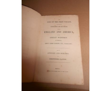
HOSKEN (James) The Logs of the First Voyage Made with the Unceasing Aid of Steam, between England and America, by the Great Western, of Bristol... also an Appendix and Remarks, by Christopher Claxton, first edition, Bristol, at the Mirror Office by John Taylor, [1838], 8vo, folding lithographed map, errata note, manuscript note relating to "grades of expansion as per letter from the commander Capt. Hosken" on front free endpaper, publisher's printed wrappers, lacks spine strip; BOURNE (John) A Treatise on the Steam Engine, 1846, 4to, folding plates, cloth a little mottled

Lot 435

History - Harleian Society. Famillae Minorum Gentium, 4 vol.; Dictionary of Mottoes in England and Wales; Visitation of Leicestershire; Bigland Pedigree Index; Visitation of Huntingdon 1684, Visitation of Derbyshire 1662-64; Yorkshire Pedigrees; Nottinghamshire and Derbyshire Visitation Papers; Visitation of Nottinghamshire 1662-64 (2 copies); together with a facsimile Essex County map after Chapman & Andre, and various other county histories, Peerage, etc.

Lot 446

GUTHRIE (William) A New Geographical, Historical, and Commercial Grammar, new edition 1777, 8vo, 19 folding maps by T.Kitchin and plate as required, contents generally good, worn cracked contemporary calf boards; [CROMWELL (T K)] Excursions in Essex, 2 vols, 1818, 8vo, folding map, plan and plates, vol. II lacks both boards (3)

Lot 497

LILFORD (Lord) Notes on the Birds of Northamptonshire, 2 vol., 1895, 4to, plates after Thorburn and Lodge, folding map, contemporary half morocco; and various others, Natural History including Morris and Goldsmith (a box)

Lot 521

HOGENDORP (Comte C S W De) Coup d'Oeil sur L'Ile de Java et les Autes Possessions Neerlandaises dans L'Archipel des Indes, Brussels 1830, 8vo, lithography frontispiece, folding coloured map, a little toned, slight foxing or spotting, calf backed boards rubbed; HONE (W) Political Tracts, new edition (no date) c.1830, 8vo, illustrations, uncut, original boards, 4pp adverts at front (2)

Lot 596

ROCHON (Alexis M) A Voyage to Madagascar and the East Indies, to which is added M.Brunel's Memoir on the Chinese Trade, London 1793 8vo, folding map (short inner tear), lacks half title, Library bookplate and neat stamp to title, calf (rubbed); PORTER (Captain David) A Voyage in the South Seas, 1823, 8vo, folding map and 3 plates, endpapers browned, recased in half calf (2)

Lot 597

WRIGHT (T) The History and Topography of the County of Essex, illustrated by W.Bartlett, in 2 vols., London: G.Virtue 1836, 4to, added engraved title, map and plates, some spotting to title, original cloth, a.e.g.

Lot 602

THESIGER (W) Arabian Sands, 1959 first edition in dustjacket, folding map in pocket end; The Marsh Arabs, 2nd impression 1964, lacking dustjacket; FERMOR (Patrick Leigh) A Time of Gifts, first edition 1977, dustwrapper; Three Letters from the Andes, first edition in dustjacket 1991 (4)

Lot 613

BRENCHLEY (Julius L) Jottings During the Cruise of H.M.S. Curacoa Among the South Sea Islands in 1865, London 1873, 4to, plates, folding coloured frontispiece and plates, folding map, contemporary half dark brown morocco. (Ref. Ferguson, 7376)

Lot 615

WAKE (R) Southwold, 1839, 8vo, tape repaired folding map, plan and plates, some foxing, later bound; GRIEVE (H) The Great Tide, 1959, 8vo, damaged wrapper; SIMS (George) Living London, 3 vols. c.1920; RIDER HAGGARD (L) Norfolk Life, reprint 1946 (6)

Lot 617

FORBES (James) Norway and its Glaciers, Edinburgh: A and C Black, 1853, folding map in pocket at end (slightly toned), lithographed views as required, later cloth

Lot 624

SHACKLETON (Sir E) South, 1919, first edition, colour frontispiece, folding map, illustrations, marginal dampstaining throughout, publisher's cloth; BAGSHAWE (T W) Two Men in the Antarctic, Cambridge University Press 1939 (2)

Lot 633

BROGGER & ROLFSEN. Fridtjof Nansen 1861-1893, Stockholm 1896, 8vo, illustrations, folding coloured map, another double page map, Swedish text, slightly browned, half calf

Lot 312

A collection of pictures, prints, maps, to include Chinese paintings on silk, 18th Century framed map of Staffordshire after Haywood, a collection of 19th Century and later maps, prints, Orient Express folder, etc

Lot 327

Three 19th century style crystoleum of a race horse, a World Map and Africa, late 20th century, all framed

Lot 124

Christopher Saxton & William Hole, a two page engraved map, Salopiae (Shropshire), 29cm x 36cm

Lot 125

Ogilby, A Map, London and Barnstable

Lot 270

A Speed map of Essex, and another

Lot 273

A pair of watercolours, of room interiors, three etchings including one of a leaping trout, a 19th century sampler, and a map of Cumbria

Lot 146

John Bartholomew & Sons Ltd for the Edinburgh Geographical Institute. A cloth mounted general map of the British isle, scale 1:633, together with a Phillips commemorative map of the Indian Empire

Lot 244

A Framed Map of Wicklow, Carlow & Wexford, together with a Coloured Engraving, View of a Continental City (2)

Lot 208

F. I. D. 1946 Thick Map set in unmounted mint horizontal pairs perforated SPECIMEN Type D21; rare multiples. SG G1s-8s (£2200)/CW SP33-40

Lot 209

F. I. D. 1946 ½d Thick Map unmounted mint, centred high, Plate 1 R3/9 extra island. SG G1aa (£325)/CW 33B

Lot 210

F. I. D. 1946 ½d Thick Map unmounted mint top marginal pair, Plate 1 R1/2 missing 'I'. SG G1b (£325)/CW 33C

Lot 211

F. I. D. 1946 ½d Thick Map used with violet South Georgia CDS, Plate 1 R1/2 missing 'I'. SG G1b (£325)/CW 33C

Lot 212

F. I. D. 1946 1d Thick Map unmounted mint, Plate 1 R3/9 extra island. SG G2aa (£170)/CW 34B

Lot 213

F. I. D. 1946 1d Thick Map fine used, Plate 1 R3/9 extra island. SG G2aa (£190)/CW 34B

Loading...Loading...
  • 109182 item(s)
    /page

Recently Viewed Lots