We found 109182 price guide item(s) matching your search
There are 109182 lots that match your search criteria. Subscribe now to get instant access to the full price guide service.
Click here to subscribe- List
- Grid
-
109182 item(s)/page


Lot 366
(Suffolk) R. Freeman Bullen: 'Sequestrations in Suffolk', 1925-26, reprinted from Proceedings of the Suffolk Institute of Archaeology and Natural History, volume XIX Pts 1 & 2, autograph letters to R. Freeman Bullen from H.A. Harris of Thorndon, 1915, & G. Cuthbert-Blad of Ringshall, 1916, loosely inserted, rebound cloth gilt, very scarce; Frederic Shoberl: 'The Beauties of England & Wales', 1813, volume XIV, illustrated John Preston Neale, 12 engraved plates of Suffolk including Mettingham, Blythburgh, Dunwich, Orford, Aldeburgh, Rendlesham, Freston Tower etc, rebound cloth gilt; John Kirby: 'The Suffolk Traveller', 1829, folding map of Suffolk (with part loss) + 4 folding road maps + 4 litho plates Woodbridge, Framlingham Castle, Leiston Abbey, Bury abbey gate, recased retaining old cloth gilt; Jones' Views of the Seats, Mansions, Castles etc...in England', [1829], 120 engraved views on 60 full page plates, Suffolk views including Kentwell Hall, Melford Hall & Helmingham Hall (2), old half calf (worn) (4)


Lot 601
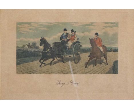
LIONEL EDWARDS Four of his illustrated works: The Fox; Moorland Mousie; Dear Busybody and Tally Ho; and three further works: FORTESCUE, HON. J.W. The Story of a Red Deer; WITTS, FRANCES, The Diary of a Cotswold Fox Hunting Lady, and TURNER, W.J., Exmoor Village (7), together with a map of 'Foxhond and Staghound Packs in the United Kingdom'; 'A Father's Advice', Sporting Verse, and After A.G. Haigh, 'Dante', all unframed
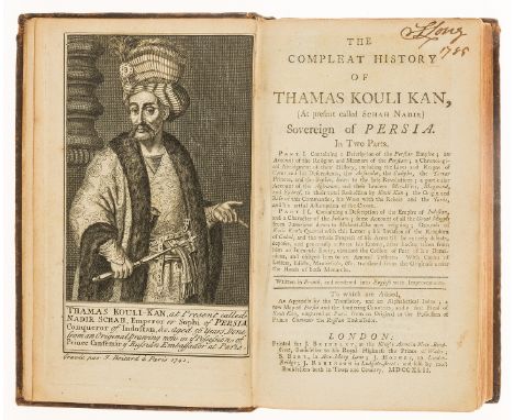
Lot 136
Persia.- Compleat History of Kouli Kan (The), (At present called Schah Nadir) Sovereign of Persia, first English translation, engraved portrait frontispiece, folding engraved map, tiny marginal worm hole to last few leaves, one or two leaves lacking corners, bookplate, contemporary calf, rebacked retaining original backstrip, slight bumping to corners, 12mo, for J. Brindley ..., 1742.⁂ According the ESTC this is sometimes erroneously attributed to Jean Antoine Du Cerceau.

Lot 147
NO RESERVE Napoleon.- Segur (Gen. Philip de, Count) History of the Expedition to Russia, undertaken by the Emperor Napoleon, in the Year 1812, 2 vol., sixth edition, half-titles, lithographed additional pictorial titles, folding engraved map (browned and offset), foxing at beginnings and ends, later half calf, spines gilt with red and green roan labels, a little rubbed, 8vo, 1827.

Lot 162
Morris (William) A Tale of the House of the Wolfings, map of Iceland, 1901; The Story of Grettir the Strong, 1901; Hopes and Fears for Art and Signs of Change, 1902; Architecture, Industry and Wealth, 1902, limited editions, each one of 315 copies, original buckram-backed grey boards, slightly marked, spines faded, printed paper labels on spines (all but the last with spare labels inside), uncut, 4to, London, Chiswick Press, 1901-02 (4).

Lot 258
Cheshire.- Ormerod (George) The History of the County Palatine and City of Chester, 3 vol., large paper copy, half-titles, hand-coloured engraved double-page map, 46 engraved plates and plans, 3 hand-coloured, illustrations, list of subscribers, occasional faint off-setting, later morocco, gilt, g.e., folio, 1819.
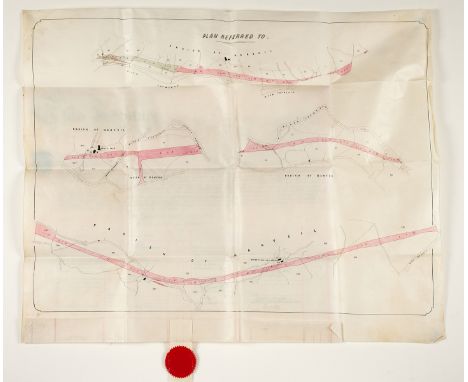
![Devon.- Risdon (Tristram) [A Continuation of the] Survey of Devonshire, first edition, title trimmed, affecting text, and lai](https://cdn.globalauctionplatform.com/883c97f4-3081-4923-8aff-ae6900b5fcf4/536adfd1-0a0c-49ef-a255-ae6900bbe6fc/468x382.jpg)
Lot 259
Devon.- Risdon (Tristram) [A Continuation of the] Survey of Devonshire, first edition, title trimmed, affecting text, and laid down, later folding engraved map bound as frontispiece, lacking preliminary advertisement, 2 engraved plates, list of subscribers with finger-posts pointing to William Gwavas of the Middle Temple and Thomas Tonkin of Llanbrigan in Cornwall, ?lacking continuation title, near contemporary calf, rebacked, upper board becoming loose, rubbed, slight bumping to corners and spine extremities, 8vo, for E. Curll, 1714.⁂ This copy has a 34pp section after the Index, headed 'The Sheriffs Continued by Mr. Coffin'. This does not appear to be included in other copies listed on ESTC or WorldCat.

Lot 264
Kent.- Lambarde (William) A Perambulation of Kent: Conteining the Description, Hystorie, and Customes of that Shyre, second edition, black letter, title within elaborate typographic border, linen-backed folding woodcut map of the Beacons in Kent, woodcut Heptarchy map, woodcut initals, occasional marginal notes in an early hand, ink inscription to title head, a little trimmed, occasional faint soiling and staining, later calf, rebacked retaining original backstrip, gilt, g.e., a little rubbed, [ESTC 15176], small 4to, Edm. Bollifant, 1596.

Lot 4
Ballooning.- Montgolfiér-style hot air balloon.- Wallis (John, publisher) Representation of the Air Baloon of Mr. Montgolfier, in the field of Mars near Paris, broadside with descriptive text below relating details of the public demonstration of Montgolfier's air balloon, etching and engraving, on laid paper with watermark of fleur-de-lis, platemark 390 x 268 mm (15 1/4 x 10 1/2 in), sheet 405 x 285 mm (15 7/8 x 11 1/4 in), two horizontal creases, some minor browning and surface dirt, handling creases, numbered '6' in brown ink to upper right quadrant, faint pencil markings, unframed, Map Warehouse, Ludgate Street, 1783.


Lot 74
DAVIS C. H. Narrative of the North Polar Expedition, US Ship Polaris. Plates, maps & illus. Quarto. Orig. green cloth gilt. Ex lib., Washington, 1876; also J. E. Nourse, Narrative of the Second Arctic Expedition, plates, maps & illus. (fldg. map in facsimile), worn orig. green cloth gilt, Washington, 1879 & vol. 1 of the Annual Report of the Secretary of the Navy for the Year 1882. (3).
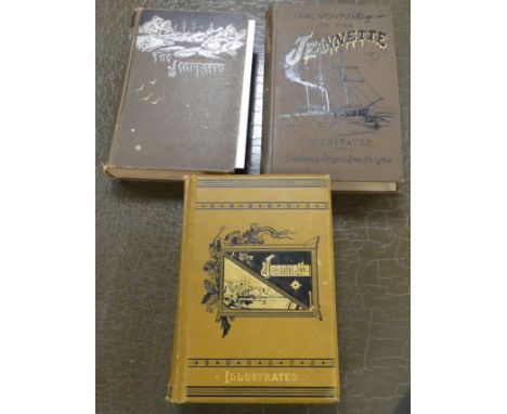
Lot 77
DE LONG GEORGE W. The Voyage of the Jeannette. Port. frontis, plates & illus. Map in pocket. Worn orig. pict. brown cloth. Old ex lib., Boston, 1888; also R. L. Newcomb, Our Lost Explorers, The Narrative of the Jeannette Arctic Expedition, 1883 & Richard Perry, The Jeannette & A Complete & Authentic Narrative Encyclopedia, 1883. (3).


Lot 94
SINCLAIR SIR JOHN (Ed). General Report of the Agricultural State & Political Circumstances of Scotland. 3 vols. Fldg. hand col. eng. map (detached), fldg. & other eng. plates as called for. Old calf. 1814; also George Robertson, General View of the Agriculture of Mid-Lothian, fldg. hand col. eng. map & other plates, calf, 1795 & a poor copy of The General View of the Agriculture in the County of Perth, 1799. (5).
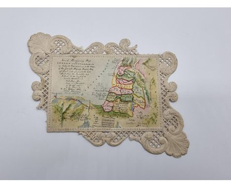
Lot 1
MANUSCRIPT MAP: 'Jewish Missionary Map of Canaan, Egypt & Arabia in Tribes & Provinces as in the Reign of His Jewish Majesty David King of Israel...illustrating the Israelites Last Return & The English & Scotch Missions to Palestine: this map is a fac-simile of the one sent to the Queen, by the Rev. William Aldis, Jewish Missionary, Alexandria July 13 1842': fine manuscript map, pen & ink with colour wash on card within embossed and pierced surround (sections missing at 2 corners) image approx 12 x 8.5cm. (1)

Lot 116
TRAVEL: SWAYNE (George): 'Lake Victoria..a narrative of explorations in search of the source of the Nile', Edinburgh & London, William Blackwood, n.d: 8vo, publishers green cloth gilt lettered, aeg, a little dusty and rubbed: BURNABY (Fred) 'A Ride to Khiva..', London, Cassell, 1877: 9th edition: publishers red cloth gilt blocked in black, map inserted to pocket inside upper board, some damp to lower edges: together with 23 others, travel, largely 19th-early 20thc. (25)


Lot 187
IRELAND: FRASER (James): 'Handbook for Travellers in Ireland, Descriptive of its Scenery, Towns, Seats, Antiquities, etc.', Dublin, James McGlashan, 1849: 735pp, final few leaves creased and torn, folding map of Ireland (pub. Chapman & Hall 1847) tipped-onto verso of final leaf and creased/ragged, title nicked to edges and contents browned, recent green half morocco gilt, 8vo. (1)

Lot 188
PATTERSON (Captain Daniel): 'Patterson's British Itinerary being a New and Accurate Delineation and Description of the Direct and Principal Crossroads of Great Britain...', London, Carington Bowles, at his map and print warehouse, 1785: with hand-coloured double-page map of England and Wales and 357 strip-maps of the road system (printed 2 to a page): 2 vols, contemporary calf gilt worn and rubbed with hinges cracked, small 8vo. (2)

Lot 189
ESSEX: 'Excursions in the County of Essex: comprising a brief historical and topographical delineation of every town and village...', London, printed for Longman, Hurst et al, 1818: 2 vols, folding map and plan, engraved titles and numerous engraved plates, contemporary green half morocco gilt, teg, a little rubbed but a good set. (2)


Lot 21
1770 edition Spectacle de la Nature or Nature Display'd Vol. IV, translated from the original French, printed for L.Davis;J. Buckland; J.Rivington; R.Baldwin;W.Strahan;W.Johnston;Hawes;Clarke and Collins, published London, containing maps, the frontispiece depicts Galileo applies the Telescope to Astronomy, calfs leather binding. Sibley Ebenezer An Universal System of Natural History including.... Volume The Second, printed for the propriertor and sold by Champante and Whitrow, rebound hardcover. This lot includes a number of 18th and 19th century books including H.Buxton Forman Keat's Poetical Works publ. 1931; Poetical Works of Sir Walter Scott published by Galiganani and Co; The Old Curiosity Shop publ. Chapman and Hall; Personal History of David Copperfield by Charles Dickens publ. Chapman & Hall; Mrs Craik John Halifax Gentleman publ. Ward, Lock & Co Limited; 1782 The Political Magazine and Parliamentary, Naval, Military and Literary Journal Vol.III printed for J.Bew London; British Bible Society The Holy Bible stereotype edition publ Bensley,Cooke and Collingwood; 1873 People's Magazine; The Leisure Hour 1874 and lastly a Geographia Road Map of England & Wales.


-
109182 item(s)/page