We found 109182 price guide item(s) matching your search
There are 109182 lots that match your search criteria. Subscribe now to get instant access to the full price guide service.
Click here to subscribe- List
- Grid
-
109182 item(s)/page


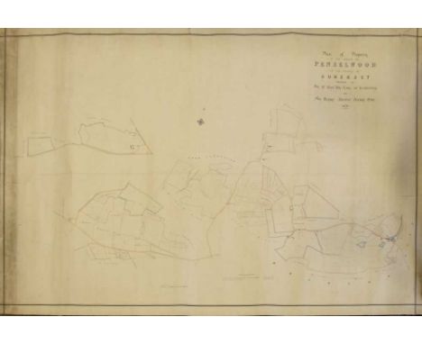
Lot 135
Maps - Penselwood, Somerset - 'Plan of Property in the Parish of Penselwood in the County of Somerset, Belonging to the Rt Hon the Earl of Ilchester and Sir Henry Ainslee Hoare Bart. 1876' - large hand-coloured estate map laid onto linen, 127cm x 178cm wide; together with a small quanity of Ordnance Survey and other rolled and folded maps (qty)

Lot 118
ROGERS (Woodes) A Cruising Voyage Round the World: First to the South-Seas, thence to the East-Indies, and homewards by the Cape of Good Hope ..., 1st edition, 8vo, London: for A. Bell and B. Lintot, 1712, with 4 folding engraved maps only (of 5, lacks world map), some creases to maps, age stains, later calf, rebacked

Lot 120
Orders of St John and Malta, collection of pamphlets, including: VIPERANI (G A) De Bello Melitensi Historia. Perugia: Andrea Brixiant, 1567, 1st edition, small 4to, lacking the woodcut map of Malta, BONNIER. Recherches, 1798; Finances of Malta, 1836; Trattato della Poverta de' Cavalieri di Malta, 1718, vellum; Istruzione del Sacro Ordine..., 2nd edition, 1724; Histoire Historique.., 1816; 2 others
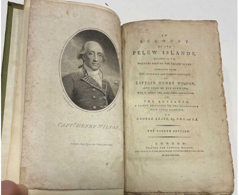
Lot 134
Literature, various. KEATE (George) An Account of the Pelew Islands, 4th edition, 1789, 8vo, engraved portrait frontispiece, folding map (with tears and repair), engraved portrait of Prince Lee Boo, uncut, later amateur binding; KINGSLEY (C) The Water-Babies, 1885, blue cloth; BURNEY (C) A General History of Music, vol. I only, 1776, 4to, calf; few others

Lot 153
Literature various, leather bindings. Collection including incomplete sets and odd volumes, mainly 18th century: COXE (W) History of Austria, 2 vols. in 3, 4to, 1806, large foldout hand-coloured map, spotting, calf; Modern Universal History, 27 vols. only, 8vo, calf; The Rambler, Sterne, Robertson, Napier, etc. Sold not subject to return. (c.130 vol.)

Lot 163
PACIAUDI (Paolo Maria) Memorie de’ Gran Maestri del Sacro Militar Ordine Gerosolimitano, 3 vols., Parma: Giambattista Bodoni, 1780, 4to, (285 x 215mm), folding map, 2 plans, circular medallic illustrations, red stamp of 'Marchesa Caraglio' to titles, full mottled calf with gilt noble crest to boards, bookplate of Richard Williams, bookseller's ticket of Francesco Fracella, Naples (3)

Lot 165
HASTED (Edward) The History and Topographical Survey of the County of Kent, 4 vols., Canterbury 1778-99, folio, folding map with out-line hand colour, engraved plates, plans and illustrations in the text, as required, a few plates mounted, occasional age and damp staining, some typical slight off-setting, contemporary calf, rubbed and cracked
![[GOODRICH (Samuel G)] Peter Parley's Tales about China and the Chinese. London 1843, square 12mo, half title, engraved map fr](https://cdn.globalauctionplatform.com/8b847b48-4e2a-48c7-96ed-af1d00f50030/330e636e-55e9-4dbe-8a82-af2b00b834a6/468x382.jpg)
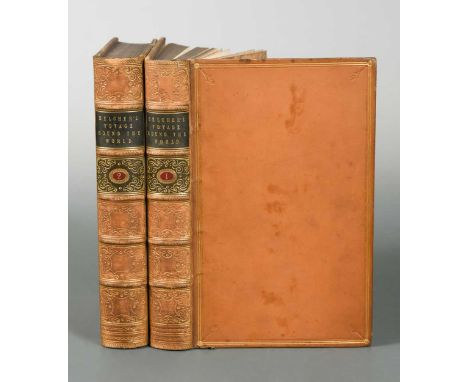
Lot 258
BELCHER (Capt. Sir Edward) Narrative of a Voyage Round the World, performed in Her Majesty's Ship Sulphur ... including Naval Operations in China, 2 vols., 1st edition, 1843, 8vo, 3 engraved folding maps, plates, as required, bound without publisher's catalogue at end, some light spotting to plates, small tear to first map, bookplates, attractive calf gilt

Lot 492
After James Cochrane Junior - reproduction map of the Island of Guernsey 20th century, likewise all of the Adjacent Rocks, Shoals & Passages, with the Tides, Soundings, Anchorages &c.', dedicated to Lord de Saumarez, Vice Admiral of Great Britain, with vignette of the Royal College of Elizabeth, 21¾ x 24½in. (55.4 x 62.3cm.) overall, framed, glazed and mounted.

Lot 524
James Cochrane Junior - A Map of the Island of Guernsey likewise all of the Adjacent Rocks, Shoals & Passages, with the Tides, Soundings, Anchorages &c.', dedicated to Lord de Saumarez, Vice Admiral of Great Britain, with vignette of the Royal College of Elizabeth, pub. April 1832, plate size 22¼ x 27¼in. (56.5 x 69.2cm.), modern gilt frame, time staining and spotting.


![HARDY (Thomas) Jude the Obscure, first edition in book form, Osgood, McIlvaine & Co., 1896 [but 1895], 8vo, etched fronti](https://cdn.globalauctionplatform.com/8b847b48-4e2a-48c7-96ed-af1d00f50030/3e272191-01b9-4617-90de-af2000b2d765/468x382.jpg)
Lot 297
CURZON (Hon. Robert) Armenia: A Year at Erzeroom, and on the Frontiers of Russia, Turkey, and Persia. John Murray 1854, 8vo, engraved frontispiece, title vignette, 4 plates and map, slight spotting to title, 32pp. catalogue at end, original cloth gilt; Visits to Monasteries in the Levant, 2nd edition, 1849, 8vo, engraved frontispiece, vignette title and plates, light spotting, chipped spine, half calf (2)

Lot 298
Cambridge. GUNNING (H) Reminiscences of Cambridge, 2 vols., 1854, 8vo, blue cloth; J & C Walker folding map of Cambridgeshire, circa 1850, 42 x 34.5cm, linen backed, cloth cover; a county map by Saxton and Kip, 31 x 35cm, maple framed; FARRER (W) Feudal Cambridgeshire, 1920; and a few other titles and prints (some mounted)
Lot 302
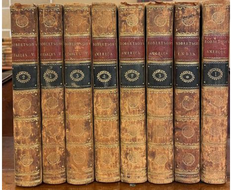
Literature, various including bindings. BULLEN (Frank T.) The Cruise of the Cachalot, 2nd edition 1910, 8vo, full calf; RANJITSINHJI (K S) The Jubilee Book of Cricket, 6th edition, 1898, 8vo, illustrated, prize calf; JESSE (Edward) Anecdotes of Dogs, London: R. Bentley 1846, small 4to, plates, light foxing, half calf; ROBERTSON (W) History of America, 4 vols. 1800, 8vo, with folding maps, and, History of India, 1799, folding map; FISH (D T) Cassell's Popular Gardening, 4 vols., 1893, cloth gilt; various others including Hume and Smollett, classical texts, The Spectator 8 vols, etc.

Lot 308
Yukon and Alaska. RICKARD (T G) Through the Yukon and Alaska. San Francisco, 1909, 8vo, illustrated, original cloth; HARRIS (A C) Alaska and the Klondike Gold Fields, 1897, embossed calf, spine slightly torn at head; SOLA (A E Ironmonger) Klondyke: Truth and Facts of the New El Dorado. Circa 1897, plates, cloth gilt; INGERSOLL (E) Gold Fields of the Klondike, 1897, 8vo, illustrated, folding map in separate envelope, cloth; SECRETAN (J H E) To Klondyke and Back, 1898, 8vo, plates, cloth; WINDT (H De) Through the Gold-Fields of Alaska to Bering Straits, 1898, 8vo, plates, cloth; 9 others similar subjects (15)

Lot 332
AUSTON (E) Historic St. Edmundsbury, illustrated by Tom Moody, with folding map dated 1946 and the artist’s original cover drawing, together with a collection of his artwork mainly relating to Suffolk and Norfolk church interiors to include details from brasses at St. Margaret’s, King’s Lynn and Holy Trinity, Orford, a watercolour of a late medieval painting of the Doomsday, Wenhaston etc., variously signed, inscribed and dated 1946-51.

Lot 389
Literature and bindings, mainly German and French texts. MOLIERE, works, 1923, 6 vols. DUMAS, 9 vols, no date, quarter calf; BALZAC (H De) Oeuvres Illustrees, 3 vols. 1867, 4to, light foxing; TIEDGE. 10 vols., 1827-33, 12mo, blue glazed boards; Kalendar auf 1819, 12mo, folding map, plates, red morocco; ANDREES Handatlas, 1921, folio, green cloth; various othersthree volumes 8vo of Des Knaben Wunderhorn, 1808, with 2 added engraved titles. Slight foxing places and bindings chipped but basically fairly good internally. From the library of Paul Hirsch.


Lot 419
CHARLES REYNOLDS & Co Album of London views in foldout format circa 1900, gilt front cover, London map to inside rear board; French 'Wessbecher Pere et Fils' illustrated catalogue 1912 of iron seats and furniture, paper wrapper; Ornamentale Plakatkunst, Residenz Verlag 1970, unbound large folio, slip case; various Dutch illustrated story books, early 20th century, and other general literature including children's, climbing series by Glyn Carr, etc


Lot 49
Post Office Directory Map of London, 1851, linen backed, folding, 73 x 94cm; Tombleson's Panoramic Map of the River Thames and Medway, new edition, publ. James Reynolds & Sons, 8pp. foldout format, hand coloured, 129 x 25.5cm, in paper wrapper; London Brighton Railway Chronicle Travelling Chart, 8vo foldout format with text, paper wrapper; (3)

Lot 50
John SpeedSuffolke described, hand coloured engraved map of Suffolk by Bassett and Chiswell, circa 1676, English text verso, creases around reinforced centre fold, one tape residue mark, slightly age toned, double glazed, 40 x 53cm; with a map of Worcestershire, published by Sudbury and Humble 1610, some discolouration, 38 x 52cm, in maple frame (2)

Lot 51
John Senex. A New Map of the English Empire in the Ocean of America or West Indies, engraved map circa 1720, hand coloured in outline, the lower portion showing a map of Jamaica, the upper part comprising smaller maps of Antigua, St. Kitts, Tobago, Barbados, Bermuda and a general map of the West Indies, unframed, 54 x 62cm (sheet)

Lot 52
J A Knipe. Geological and Mineralogical Map of England and Wales, with parts of Scotland, Ireland and France, folding coloured dissected map, 1839, 108.5 x 78.5cm, with wallet case; and another small folding world map by C. Smith 42 x 64cmgood colouring. No major issues. slight staining to wallet case.


Lot 54
William Smith Lancastriae Comitatus Palatinus, uncoloured engraved map of Lancashire, 1603 or later, uncoloured, 38 x 49cmslight undulation to paper, few creases, few small spopts or marks, but geneally a good clean looking example. Plate mark and centrefold visible. From a private collection.

Lot 71
OLAUS (Magnus) Historia... de Gentium Septentrionalium. Basel: ex Officina Henric. Petrina 1567, folio, 2nd Latin edition, woodcut device to colophon, lacking the map of Scandinavia (supplied in good facsimile), numerous woodcuts, some water staining to upper leaves up to p.107, some age toning and spotting, old vellum, bookplate of John Kerrich of Geldeston Hall with his library stamp twice to title page

Lot 72
Bible, King James version, London: Robert Barker 1612, small 4to, prayer book lacks title at the start, engraved general title by Jaspar Isac, map of Canaan present, with 'hee' reading in Ruth III, wood engraved NT title, Psalms at end dated 1612 (Companie of Stationers) and lacking all after Psalm 136, general age toning to text, upper board detachedPlease note the binding is broken to the text block


Lot 3313
Japan.: Map of Japan and adjacent regions. Tokyo, Kokusai Bunka Shinkokai 1937. Chromolithogr. Karte, in Segmenten auf Lwd. kasch. u. mehrf. gefalt. (ca. 200 x 170 cm), mit Textheft (22 S.) zus. in Olwd.-Kassette. (Lichtrandig). Zeigt Japan und Korea mit Teilen von China und Rußland. Hrsg. von der Gesellschaft für Internationale Kulturelle Beziehungen Tokyo. - ╔Dabei:╗ Propaganda-Schrift Japan (in jap. Sprache) ca. 1940. D
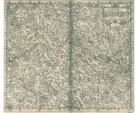
Lot 388
Guler v. Weineck,J.: Raetia: Das ist, Außführliche und warhaffte Beschreibung der dreyen Loblichen Grawen Bündten un(d) anderen Retischen Völcker. Zürich, J.R. Wolff 1616. Kl.Fol. Mit Kupfertitel (mit Ansichten von Chur u. Augsburg), 1 gest. Portrait, 5 Kupferstichkarten (4 dplblgr., 1 gefalt.) v. Matthias Hirzgartner, 4 dplblgr. Stammtaf., 1 dplblgr. Tabelle u. zahlr. Textholzschn. 19 (1 w.) nn., 225 num. Bl. Prgt. d. Zt. mit Schließbändern. (Etw. fleckig). Haller IV, 814. Lonchamp 1553. Barth 20316. Wäber 327. Feller-Bonjour 387 ff. Blumer, Gesamtkarten der Schweiz No. 85. Erste Ausgabe. - Gulers Hauptwerk. "Dieses überaus schätzbare und selbst in Bündten seltene Werk enthält eine vollständige Nachricht vom alten Rhätien" (Haller). "Es zeugt von der umfassenden Belesenheit und Landeskenntnis Gulers" (ADB X, 116). Die Textillustr. mit Wappen, Portraits, kl. Ansichten, historischen Szenen u.a. - Tls. leicht fleckig, Bl. 200 mit Einriß, Gesamtkarte mit langem hinterl. Einriß, vord. Vors. repar. - Exlibris. - First Edition. With engraved title (with views of Chur a. Augsburg), 1 engraved portrait, 5 engraved maps (4 double-leaf, 1 folded) by Matthias Hirzgartner, 4 engraved genealogical tables, 1 double-leaf table a. numerous wood engravings in text. 19 not num., 225 num. pp. parchment of the time with ribbons. (Somewhat spotted). - Slightly spotted in parts, pp. 200 with tear, overall map with long backl. tear, front endpaper repaired. - bookplate.

Lot 2064
Dapper,O.: Naukeurige Beschryving der Eilanden, in de Archipel der Middelantsche Zee, en ontrent dezelve, gelegen: Cyprus, Rhodus, Kandien, Samos, Scio, Negroponte (etc.). Amsterdam, Wolfgangh u.a. 1688. Fol. Mit gest. Titel, 5 (statt 6) dplblgr. Kupferkarten, 26 (davon 12 dplblgr.) Kupfertafeln u. 47 Textkupfern. 3 Bl., 92 (recte 100), 320 (recte 436), 40 S., 2 Bl. Ldr. d. Zt. (Rckn. mit Fehlstelle, beschabt, stark best., Hdeckel mit Einschnitt). Tiele 302. Contominas 190. Blackmer 453 Anm. Zacharakis 878 ff. Erste Ausgabe. - Mit den bekannten Inselkarten und -ansichten, darunter nördliche und südliche Ägäis, Zypern, Rhodos, Chios, Tenedos, Kreta etc. Die Textkupfer ebenfalls mit Ansichten und Karten sowie Darstellungen von Tieren und Pflanzen. Das Tafelverzeichnis führt nur 30 Karten und Tafeln auf, zusätzlich vorhanden sind hier eine zweite Rhodos-Tafel und Plan mit Ansicht von Candia. Paginierung wie immer stark fehlerhaft. - Ohne die Übersichtskarte. Schwach gebräunt u. tls. etw. fl., tls. schwache Randläsuren (vereinzelt bis in den Text od. das Bild reichend; wenige ausgebessert). Zypern-Kte. seitlich knapprandig u. ausgefranst (links bis in den Kartenrand), 2 Bl. mit Wurmlöchlein im Text. - With engraved Title, 5 (instead of 6) double-leaf copper maps, 26 (of which 12 double-leaf) copper plates a. 47 copper plates in text. 3 pp, 92 (recte 100), 320 (recte 436), 40 pp, 2 pp. Leather binding of the time (spine with missing, scuffed, heavily bumped). - - Without the general map. Slightly browned and partly spotted, partly weak marginal tears (occasionally reaching into the text or the image; few repaired). Map of Cyprus laterally scarcely margined and frayed (on the left into the map margin), 2 pp. with wormholes in the text.
Lot 3309
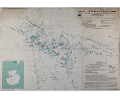
Antarktis.: Map of the Queen Maud Mountains Between Longitudes 1750 and 1350 W. from the surveys of the Byrd Antarctic Expedition. Scale 1:500.000. Farb. Karte für die American Geographical Society, NY 1931. Blgr. 53,5 x 75 cm. Mit Insetkarte unt. li. "General location of Africa of the map" (ca. 17 x 13,5 cm) u. "Elements of the map" u. "Method of constructing the map" im unt. re. Eck. Mit Bibl.-St. u. hs. Eintrag im ob. li. Rd. Mehrf. gefalt. Gedruckt auf Blandford Bold Papier. - Falze u. Ränder tls. eingerissen, ob etw. angestaubt, ob. re. Eck mit Randeinriss ca. 5 cm i.d. Titel. R

Lot 3440
Weltkarte.: Diversi Globi Terr-Aqvei, Statione Variante et Visu ... Kolor. Kupferstichkarte bei M.Seutter, Augsburg ca. 1730. 49,5 x 57 cm. Unter Passep. u. gerahmt (nicht ausgerahmt). Kl. Alterssp. - Die Erde in 2 Hemisphären, umgeben von 8 kleineren Projektionen der Erde u. 4 astronomischen Diagrammen. Mit 2 Schriftkartuschen u. Darstellungen der Winde als blasende Putten. Kalifornien noch als Insel dargestellt. - Mit Mittelfalz. - Colored copper map by M.Seutter, Augsburg c. 1730.

Lot 300
Luther,M.: Der Erste (-achte) Teil aller Bücher und Schrifften. 8 Bände. Jena, Rödingers Erben (Tle. 1 und 4: C. Rödinger; Tl. 5: D. Richtzenhain), 1555-60. Folio. Mit 8 großen Holzschnitt-Titelvignetten (wdh., 2 leicht abweichend) und 11 Textholzschnitten (7 wdh. blattgroß). Pergamentbände der Zeit. VD 16, L 3323, 3335, 3348, 3326, 3330-31, 3336-37.- Goedeke II, 151. - Vgl. Knaacke 17. - Jenaer Gesamtausgabe von Luthers Werken, mit den berühmten Holzschnitten Papstesel und Mönchskalb sowie der Weltkarte Daniels Traum. Der Titelholzschnitt zeigt Luther und Kurfürst Johann Friedrich von Sachsen, der blattgroße Holzschnitt mit Brustbildern der drei sächsischen Herzöge mit ihren Wappen, monogrammiert "P G". Die übrigen Holzschnitte zeigen Papstese l (wdh.), Mönchskalb und Weltkarte (Daniel's Dream Map , vgl. Shirley 65A). - Erste Auflage, lediglich Bde. 2 und 3 in zweiter Auflage (1558/60). Ohne den erst 1864 erschienenen Registerband. - Bde. 1, 2 und 8 stellenw. mit Feuchtigkeitsspuren; die übrigen Bde. tls. etw. wasserrandig und vereinz. mit Wurmspuren, einige Bll. gebräunt oder stockfleckig. Einbde. etw. fleckig, Kantenbezug tlw. gelöst. - 8 volumes. Jena edition. With large woodcut title border (rep., 2 varying) and 11 partly full-page woodcuts (rep.), among them the worldmap "Daniel's Dream Map" (cf. Shirley 65A). Contemp. vellum. - Without the later published index volume. - Vols. 1,2 and 8 partly with traces of damp, the other vols. partly somewhat waterstained, here and there worming, some leaves browned or foxed. Some staining to bindings, covering partly detached at edges.


-
109182 item(s)/page