We found 109182 price guide item(s) matching your search
There are 109182 lots that match your search criteria. Subscribe now to get instant access to the full price guide service.
Click here to subscribe- List
- Grid
-
109182 item(s)/page


Lot 117
Railway carriage interior posters, framed, including Map of London, Brighton & South Coast Railway routes, a similar covering South Eastern & Chatham Railway, and two Southern Railway coloured posters "The Dorset Coast - Go by Train" and "The Hampshire Coast", plus two empty matching glazed frames


Lot 1791
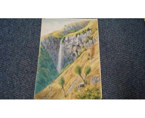
Of topographical interest: L W Wilson, 'Waterfall, Mount Steed, Rakaia Gorge, Canterbury, New Zealand' initialled and dated 1873, further signed, dated and inscribed verso, watercolour, 28 x 20.5cm, unframed; together with an antique map of Buckingham, by John Speed, unframed; and another Renaissance style portrait by P Boyd.


Lot 91
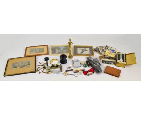
A mixed lot of collectors' items to include The Indcol Coloured Lantern slides in original box, a chromed map reader/compass with magnifying glass to finial, an ebonised hair tidy, a ceramic and glass eye prosthetic, a late 19th century miniature bisque doll, Macclesfield silks, a collection of early 20th century and later postcards, etc.


Lot 334
A new and complete Chart of The World displaying the tracks of Captain Cook and other modern navigators, engraved for Bankes's New System of Geography published by Royal Authority, drawn and engraved by T. Bowen together with a Map of Gloucestershire drawn and engraved for Lewis Topographical Dictionary, engraved by J&C Walker (2)
Lot 378
An 18th Century monochrome Map "An Accurate Map of The Counties of Gloucester and Monmouth" to the Honorable John Thynne, Honorable Lord Chedworth, Lord Lieutenant of The County of Gloucester printed for Robert Wilkinson in Corn Hill, Carrington Bowls in St. Paul's Churchyard, Robert Sayer and The Golden Buck in Fleet Street, later framed and glazed, 51.5cm x 68cm
![Fine Bindings: [SIR EDGAR BULWER-LYTTON] "The Pilgrims of the Rhine" Saunders and Otley, Conduit Street 1834, engraved fronti](https://cdn.globalauctionplatform.com/91ff4910-da2e-4981-8b14-a71401011705/7c6e0849-087a-4ce1-d815-c7c8227ef942/468x382.jpg)
Lot 482
Fine Bindings: [SIR EDGAR BULWER-LYTTON] "The Pilgrims of the Rhine" Saunders and Otley, Conduit Street 1834, engraved frontis with tissue-guard, engraved vignette on half-title, plates and headers, some foxing, T. Sotheran, Bookseller and Stationer, 10 Little Tower Street and ex libris plates inside front board, full green Morocco, heavy gilt tooling, raised bands and gilt titles to spine, gilt dentelles, a.e.g.; BRETON, M., Vol III of "China: Its Costume, Arts, Manufactures &c." Howlett and Brimmer 1824, colour plates and frontis, full-leather gilt decorations, all rather bumped and rubbed; Vol II "LES DELICES DE L'ITALIE..." Paris 1707 par le Compagnie des Libraires, engraved half-title, folding plates, small octavo, front board and half-title separating full-leather, some damage to plates; QUIN, MICHAEL J, "A Steam Voyage Down the Danube..." (two volumes) Richard Bentley, New Burlington Street, 1835, frontis to both volumes, plates and map to Vol I, half-leather, gilt titles and decorations to backstrip, rubbed (5)

Lot 487
Guthrie, William and Gray, John "A General History of the World from the Creation to the Present Time...", London: J. Newbery, R. Baldwin, S. Crowder etc., 1764, 12 volumes, full speckled leather, most pastedown titles missing, some offsetting from plates, stitching loose and cracked to Vol XII . Vol I with folding map of Ancient Egypt, seven plates, five folding; Vol II frontis folding map, two folding plates, Vol III folding map and two folding plates, Vol IV frontis folding map, Vol V no plates or maps , Vol VI frontis folding map of the world, Vol VII no maps or plates, Vol VIII no maps or plates, Vol IX folding map frontis and folding map of United Provinces, Vol X folding map frontis - Italy, Vol XI no plates or maps, Vol XII no plates, (12)

Lot 495
ALLOM, THOMAS and BARTLETT W.H. "Devonshire Illustrated, in a Series of Views of Cities, Towns, Public Buildings..." and "Cornwall Illustrated, in a Series of Views of Cities, Towns, Public Buildings..." Fisher Son and Co, London 1829 and 1831, both with county map frontis, vignette on title page, numerous plates (two engravings to each plate), some foxing and staining, contemporary marble boards, quarter leather backstrips bumped and rubbed, (backstrip of "Cornwall Illustrated" has some loss); COLLINS, W. WILKIE "Rambles Beyond Railways; or, Notes in Cornwall Taken A-foot" illustrated by Henry C. Brandling, London 1851, frontis with tissue-guard, tinted plates, eleven plates plus frontis, marble boards half-leather, backstrip and corners bumped and worn, library plate inside front board; BADDELEY, WELBORE St. CLAIR, "A Cotteswold Shrine, Being a Contribution to the History of Hailes..." Gloucester: John Bellows and London: Kegan Paul, Trench, Trubner & Co Limited 1908, frontis cover, photographic plates, small folio, inscription dated 1937 on ffep, cream boards, paste-down to backstrip with loss (4)
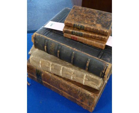
Lot 497
BROWN, the Rev. John, "A Dictionary of the Holy Bible..." Samuel Leigh 1814 London, two volumes, folding coloured map to both volumes, full tree-calf lrather, gilt decorations, paste-downs to backstrip, "Concordance to the Holy Scriptures" Mathews and Leigh 1811, frontis portrait, full-leather; HOLY BIBLE printed by T Wright and W Gill 1769 Oxford, folio full-leather, backstrip worn and with loss; HOLY BIBLE Oxford University Press 1882, full-leather with brass clasp, bumped and worn, HOLY BIBLE printed by George E Eyre and William Spottiswoode 1861, full-leather with gilt blind stamp decorations, covered with buckskin wrapper (6)
Lot 498
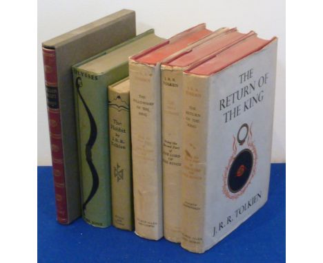
TOLKIEN J.R.R. "The Lord of the Rings" George Allen & Unwin Ltd in three red cloth volumes, dust jackets not price-clipped: "The Fellowship of the Ring" eighth impression 1959, "The Two Towers" sixth impression 1959 and "The Return of the King" fourth impression 1958. All three volumes have inscriptions 'Birdwood - Trinity' in ink inside front boards (hidden by dustjacket flaps) and the third volume has a slight crease to its front board. JOYCE, JAMES, "Ulysses" The Bodley Head, 1958 reprint, green cloth with bow blind stamp and gilt titles, green dust jacket not price-clipped, TOLKIEN J.R.R. "The Hobbit or There and Back Again" George Allen and Unwin, 11th impression 1959, illustrated by the author, map on endpapers, green cloth with black decorations and a Folio Society volume (6)


Lot 49
(MAZUCHELLI ELIZABETH S.). The Indian Alps & How We Cross Them, by a Lady Pioneer. Fldg. map (small tear without loss), 10 col. litho plates & many vignettes. Small quarto. Rather worn orig. maroon cloth gilt, splitting internally at hinge, some internal spotting, mainly opposite plate pages. 1876; also 1969 reprint of Colonel Kirkpatrick's Account of the Kingdom of Nepaul, in orig. purple cloth & torn d.w. (2).

Lot 143
An architectural watercolour of the facade of a stone country house, by Hartshorne Architects, (apparently never built), 56 x 73cm; 'Broughton Hall' a faded watercolour architectural study, 25 x 36cm; "Carte du départment de L'Eure", hand-coloured pen and ink map by ''Legaud'', 1852, 56 x 83 cm (some loss and damaged); together with "Plan de Dieppe", engraving, 1786, (previously folded), 62 x 87 cm; and one other smaller town plan (5)

Lot 175
MEYRICK (Samuel Rush) The History and Antiquities of the County of Cardigan, London: T. Bensley, 1808, 4to, 20 engraved plates (one folding) as called for, slight offsetting on to title, a few sporadic fox marks, bookplate of Sir Robert Peel, contemporary full polished calf gilt, a crisp copy; JONES (Theophilus) A History of the County of Brecknock, 2 vol., Brecknock: for the Author, 1805, 4to, engraved vignette titles, 2 hand-coloured folding maps (small tears), 28 plates and 3 hand-coloured leaves of armorial shields, foxing/spotting to titles and plates, occasional dust staining to text, generally a little toned, half calf (rubbed); MALKIN (B. H.) The Scenery, Antiquities and Biography of South Wales, 1804, 4to, folding map, lithographic plates, rebacked calf (4)

Lot 303
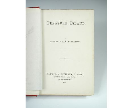
YSTEVENSON (Robert Louis) Treasure Island, first edition Cassell & Co Ltd 1883, 8vo, an early issue, frontispiece treasure map, tissue guard, publisher's red cloth with gilt-lettered spine, spine slightly faded, boards slightly stained and cocked, 8pp adverts at end marked '5R-1083', slight foxing to contents leaves and p.1, fore edge spotted; with the following first issue points: "dead man's chest" not capitalised on pages 2 or 7; the first letter of "vain" is broken in the last line on page 40; the "a" is missing in line 6, page 63; the full-stop is not present after "opportunity" in line 20, page 178; "worse" for "worst" in line 3, page 197. Armorial bookplate of Sir Mervyn Peel, his signature and tipped in bookseller's catalogue slip, contemporary neat prize inscription dated March 1884 to half title.

Lot 34
Chapman and Andre Two large scale map sections of Essex, hand coloured engravings published 1777, plates VII and XVI, 47 x 57cm (plate size); C and J Greenwood Map of the County of Essex, hand coloured engraved map published 1831, with vignette of Audley End House to lower right, 60 x 70cm (3)


Lot 36
Island of Ceylon by Fullarton & Co, a hand coloured steel engraved map c.1860, plate XLII, from 'British Possessions in the Indian Seas', 45 x 31cm; and Thomas Kitchin, New Map of Indostan or East Indies, c.1780, hand coloured engraving, 35 x 39cm; and Cambridgeshire by Thomas Moule, and a small map of Asia by R. de Vaugondy (4)


-
109182 item(s)/page