

Original vintage sport poster map for the Innsbruck XII Olympic Winter Games 1976 held in Tirol, Austria. This poster features a great map showing the city of Innsbruck and the various locations and tracks used for the Olympic competitions, set in a broad valley between high mountains, with the list of competitions listed at the bottom in German, French, English and Russian. The 1976 Winter Olympics, officially known as the XII Olympic Winter Games (French: XIIes Jeux olympiques d'hiver, German: Olympische Winterspiele 1976), were a winter multi-sport event which was held between February 4 and February 15, 1976 in Innsbruck, Austria. It was the second time the Tyrolean city hosted the Games, which were awarded to Innsbruck after Denver, the original host city, withdrew in 1972. Printed in Austria. Condition: Excellent condition.. Country of printing: Austria, designer: H. Berann, size (cm): 55x64, year of printing: 1976.
We found 109182 price guide item(s) matching your search
There are 109182 lots that match your search criteria. Subscribe now to get instant access to the full price guide service.
Click here to subscribe- List
- Grid
-
109182 item(s)/page

Original vintage travel advertising poster: Wine of Italy. Published by the Italian Foreign Trade Insitute, this poster features a wonderful map of Italy listing and locating all of the Italian wines with a Controlled Denomination of Origin. The map also features some of Italy's most famous landmarks and cartoon like characters engaging in various activities throughout the country. Printed in Italy by Litho Masi - Portici. Condition: Good condition, small tears, minor creasing on edges, stain on margin.. Country of printing: Italy, designer: Unknown, size (cm): 100x70, year of printing: 1970.
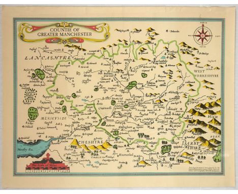
Original vintage map of the county of Manchester (1610) by John Speed (1552-1629), an English cartographer and historian. Printed in 1976 by the local council most likely to promote tourism. Inscription at the bottom right states that the map was adapted by the Greater Manchester Council Public Relations Office and Cartographic Service. Alongside Christopher Saxton, Speed is one of the best known English mapmakers of the early modern period. His atlas The Theatre of the Empire of Great Britaine was published in 1611 and 1612, and contained the first set of individual county maps of England and Wales besides maps of Ireland and a general map of Scotland. The map also features other counties in relation to Manchester - Lancashire, West Yorkshire, Cheshire and Derbyshire. Condition: Good condition, small tear. Country of printing: UK, designer: John Speed, size (cm): 45x58, year of printing: 1976.
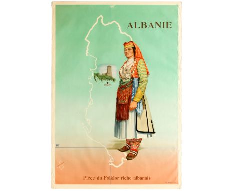
Original vintage travel advertising poster Albania - Part of the Albanian Rich Folklore / Albanie, Pièce du Folkor riche Albanais - Featuring a great illustration by Dh Mbarja of a woman in traditional Albanian clothing and a head scarf stood in front of a map of Albania - The capital city Tiranavis marked on it under an illustration of a castle. Albania, on Southeastern Europe’s Balkan Peninsula, is a small country with Adriatic and Ionian coastlines and an interior crossed by the Albanian Alps. Condition: Good condition, creasing and tears on margins.. Country of printing: Albania, designer: Dh Mbarja, size (cm): 104x71, year of printing: 1956.

Original vintage map poster Our Flying Ambassadors and Their Routes - Great design features portraits of Charles Lindbergh, Lt. Lester Maitland, Com. Richard Byrd, William Brock, Eward, Schlee, Clarence Chamberlain, and Lt. Albert Hegenberger, along alongside an illustration of planes and an eagle. Two maps show routes taken by early aviators, one is a northern polar projection and the lower map is titled "Lindbergh's Aerial Tour of Latin America." A key gives details for the travel routes including - 1924-US Army Aviators Circumnavigate The Globe, 1926-Overflying the North Pole--Byrd-Bennett Spitzburgen to Teller, Alaska, 1926-Amundsen-Ellsworth-Nobile -- Polar overflight, 1927-Charles Lindbergh--New York to Paris, 1927 Chamberlin-Levin--Germany to New York, 1927 Maitland-Hegenberger--San Francisco to Honolulu, 1927 Byrd-Noville-Acosta-Balcheu--New York to Ver-Sur-Mer, France, 1927 Brock-Schlee--Newfoundland to Tokyo, 1927-28 Lindbergh Pan-American Tour. Published by C. S. Hammond & Co and The Pittsburgh Press. Condition: Acceptable condition, staining, folds, tears, creasing.. Country of printing: USA, designer: Unknown, size (cm): 58x38, year of printing: 1929.
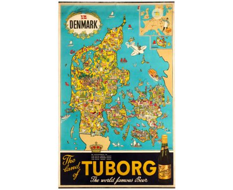
Orginal vintage advertising poster for Tuborg beer: Denmark - The land of Tuborg - The world famous beer. Great illustrated map of Denmark by Hakon Mielche (1904-1979) with a small map of Europe in the top right corner and a photograph of a bottle of Tuborg beer placed in the bottom right corner, alongside the title. Tuborg Brewery is a Danish brewing company founded in Northern Copenhagen in 1873 by Carl Frederik Tietgen. Hakon Mielche was a Danish travel book writer, journalist, visual artist and adventurer who published a large number of books and traveled for many years for the Weekly Family Journal. Lithograph printed by Andreasen & Lachmann. Condition: Good condition, staining, creasing, metal bars.. Country of printing: Denmark, designer: Hakon Mielche, size (cm): 100x62, year of printing: 1950s.
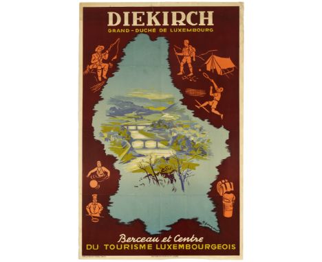
Original vintage travel advertising poster for the district of Diekirch, part of the Grand-Duchy of Luxembourg, described here as the cradle and centre of the Tourism of Luxembourg (Diekirch - Berceau & Centre du Tourisme Luxembourgeois). It features a fantastic artwork by Gerson showing a scenic view of the river Sure running across the green countryside of the Diekirch district with a couple of bridges crossing the river to connect villages sitting on the river banks. In the background, some small mountains can be seen. The image is inserted inside a map of Luxembourg with small drawings on the edge of the map showing people undertaking different activities, including fishing, swimming, cooking, playing tennis and hiking. Published by the Diekirch Tourism Board and printed in Luxembourg by Imp. Art. Ed. Huss & Cie. Condition: Fair condition, folds, staining, creasing.. Country of printing: Luxembourg , designer: R. Gerson, size (cm): 99.5x63.5, year of printing: 1950s.
Original vintage WWII propaganda poster featuring a war map showing the battleground around Kohima and Dimapur and the military strategy of the British Indian Troops to fight the Japanese Army during the Burma Campaign. The Burma Campaign, which took place towards the end of WWII in 1944 and 1945, resulted in the defeat of the Japanese Army and the liberation of Burma after it had been invaded by the Empire of Japan in 1942. Condition: Good condition, small tears, creasing.. Country of printing: Burma, designer: Unknown, size (cm): 41.5x52.5, year of printing: 1940s.

Original vintage advertising poster featuring a illustrated map of the Cheeses and Wines of France (Fromages et Vins de France). This colourful map highlights the various cheeses and wines according to the different regions, but it also gives practical recommandations and advices, including which cheese marrying with each type of wines, how to preserve both the wine and the cheese, and an explaination about the different kind of wine glasses, among other informations. Condition: Good condition, creasing, folds, . Country of printing: France, designer: Unknown, size (cm): 98x69, year of printing: 1970s.

Original vintage propaganda poster of the Allied occupation areas after World War 2. This colourful and detailed map depicts areas of Germany and central Europe occupied by the Allied nations following the Potsdam conference of 1945, where Germany was partitioned. The key at the bottom shows the various Allied control zones by colour coding - Russian (Soviet), American, British and French zones. Condition: Good condition, folds, small tears, browning.. Country of printing: Germany, designer: Atlanta service Frankfurt, size (cm): 59x42, year of printing: 1940s.
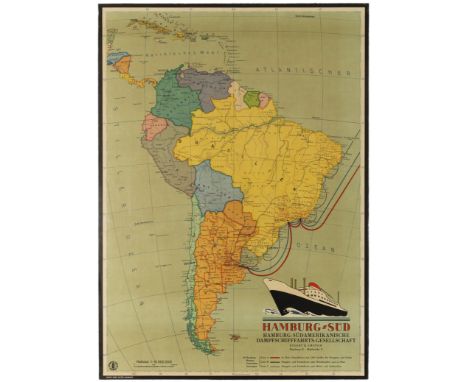
Original vintage travel advertising poster published by the Hamburg-South American Steamship Company (Hamburg-Südamerikanische Dampfschifffahrts-Gesellschaft) in the 1930s to advertise its cruise line services to Brazil, Uruguay and Argentina. The poster features a colourful map of South America showing the steamship routes stopping over in the cities of Rio de Janeiro, Sao Paulo, Montevideo and Buenos Aires, all located on South America's Atlantic coast. In the bottom right corner of the poster figures a small image of a steamship from the Hamburg-South American Steamship Company. Printed in Germany by Gebr. Sulter, Hamburg. Condition: Good condition, creasing, light stains, small tears, backed on old linen.. Country of printing: Germany, designer: Unknown, size (cm): 96x68, year of printing: 1930s.


Australia.- Salvado (D. Rudesindo) Memorie Storiche dell'Australia particolarmente della Missione Benedettina di Nuova Norcia, folding engraved map frontispiece, spotting, contemporary cloth-backed boards, spine label in manuscript, a little rubbed, slight bumping to corners, 8vo, Napoli, 1852.
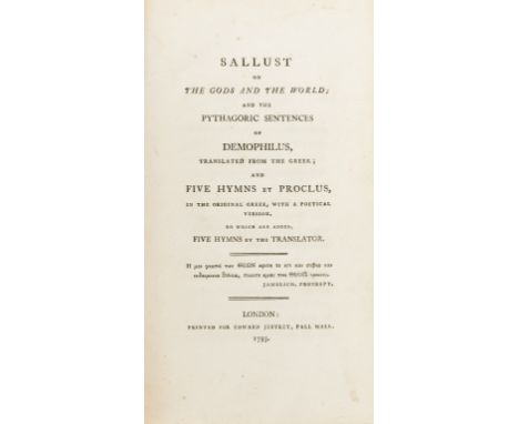
Taylor (Thomas) Sallust on the Gods and the World, first edition, bound without half-title or advertisements, bookplate, contemporary calf, rebacked, bumping to corners, 1793 § Phillips (Charles) A Garland for the Grave of Richard Brinsley Sheridan, first edition, occasional faint spotting, later calf-backed boards, rubbed joints, 1816 § Macfarlane (Charles) The Seven Apocalyptic Churches, 8 engraved plates and 1 map, occasional faint marginal staining, upper hinge broken, later cloth-backed boards, rubbed, 1832; and 5 others, similar, 8vo & ob.4to (8)

American imprint.- Quaker ownership.- Moore (John) A journal during a residence in France, from the beginning of August, to the middle of December, 1792. To which is added, an account of the most remarkable events that happened at Paris from that time to the death of the late King of France, 2 vol., folding engraved map frontispiece, short tear just within platemark, some staining and browning, contemporary mottled / tree calf, rather worn, large 12mo, Chambersburg [PA], Printed by Andrew Dover, for Mathew Carey, and London Printed: New-York, reprinted, 1797-1794.⁂ Provenance: Mira Sharples Townsend (ink ownership inscriptions) and Jesse Sharples (Sharpless). The latter a Quaker social activist and reformer in Philadelphia. A Jesse Sharples was the first man to be tried for obscenity in the state of Pennsylvania for exhibiting for money a picture of 'a man in an obscene, impudent, and indecent posture with a woman'.

NO RESERVE Travel and science.- Raleigh (Sir Walter) Discoverie of the Large and Bewtiful Empire of Guiana, limited edition, plates, original vellum-backed cloth, uncut, The Argonaut Press, 1928 § Dawson (Warren R., editor) The Banks Letters, original cloth, dust-jacket, 1958 § Hakluyt (Richard) The Principall Navigations Voiages & Discoveries of the English Nation, 2 vol., folding map, original cloth, dust-jackets, Cambridge, 1965; and c.70 others, 8vo (c.75)
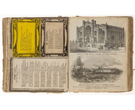
Methodism.- Scrap album relating to Methodist missionary work, comprising printed poems, ballads and obituaries, and engravings, including a single sheet poem by Dr Denman, Sweet Home, printed by J. Pannell, Horncastle, original boards, worn, [c.1830s]; and 3 others, Methodism, including bound pamphlets on the Kikuyu controversy and a provincially printed book in aid of the funds for rebuilding Alveston Church, 4to & 8vo (4)⁂ The first mentioned includes: an engraved map of the Methodist mission stations in Caffraria, portrait engravings of Reverend John Wesley and other Methodist reverends, engraved views of churches, chapels, and schools in Jamaica, St. Helena, Trinidad, Antigua, Ceylon, Haiti, Calcutta, Kandy, and the Wesleyan Mission premises in St. Mary's, Western Africa. First mention provenance: bookplate of "E. Franks"
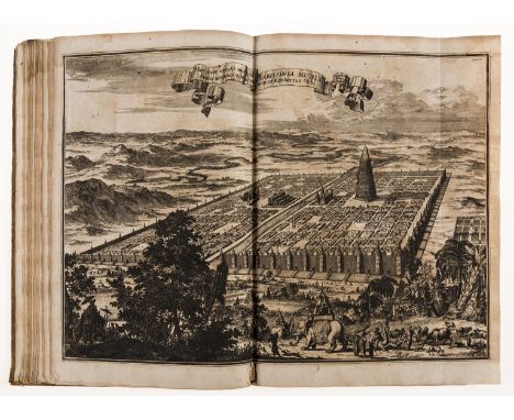
Kircher (Athanasius) Turris Babel, sive Archontologia, first edition, Amsterdam, Janssonio-Waesbergiana, additional engraved title after Gerard Lairesse, 10 engraved plates only (of ?12), 7 folding and/or double-page, 4 with tears, double-page engraved map, illustrations, several full-page, v2 & v3 misbound, browning and spotting, worming (not affecting text), later calf, rubbed and worn, loss to spine extremities, bumping to corners, folio, 1679.
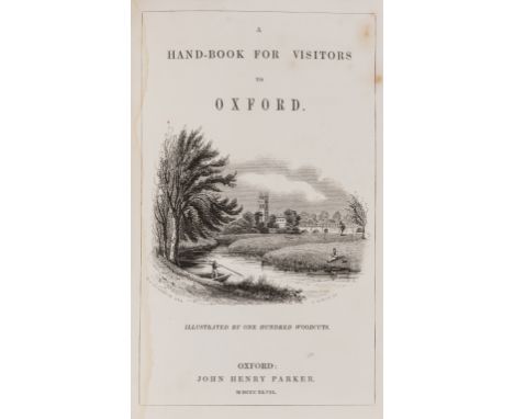
NO RESERVE Oxford.- Wood (Anthony) Athenæ Oxonienses. An Exact History of all the Writers and Bishops who have had their education in ... Oxford, 2 vol., titles in red and black, list of subscribers, rather browned in places, bookplate of Ham Court, contemporary panelled calf, rebacked, slight bumping to corners, 1721 § [Parker (John Henry)] A Handbook for Visitors to Oxford, first edition, engraved frontispiece and vignette title, illustrations, folding map at end, spotting, original pictorial cloth, Oxford, 1847, 8vo (3)
![Burton (Sir Richard Francis) [Works], 7 vol., "Memorial Edition", 37 plates (of which, 9 chromolithographed and 8 tinted lith](https://cdn.globalauctionplatform.com/9ff7d2ec-98fb-41a5-8315-ab8e00edfbf6/4fe56176-12b8-4bcd-81e7-ab8e00f1a4ac/468x382.jpg)
Burton (Sir Richard Francis) [Works], 7 vol., "Memorial Edition", 37 plates (of which, 9 chromolithographed and 8 tinted lithographed plates), 1 folding colour map, 5 plans (3 folding), illustrations, spotting, bookplates or remnants of bookplates, 2 vol. with neat ink signature of previous owner, original pictorial cloth, gilt, 4 vol. with spine ends strengthened, rubbed and worn, bumping to spine extremities, [Penzer pp.54-55; 64-65; 73-74 and 82-83], 8vo, 1893-94.
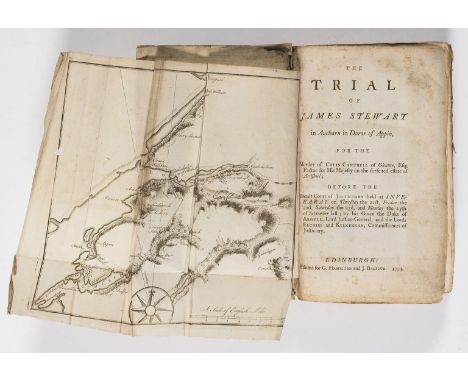
NO RESERVE Stevenson (Robert Louis).- The Trial of James Stewart in Aucharn in Duror of Appin, for the Murder of Colin Campbell ..., folding engraved map frontispiece, small marginal hole, occasional spotting, contemporary boards, rebacked, title in manuscript to upper cover, a little rubbed, 8vo, Edinburgh, 1753.⁂ An important account of a notable trial, given greater notoriety when Robert Louis Stevenson incorporated a fictionalised account of it into his novel 'Kidnapped.'
Cobbett (William) Advice to Young Men, and (Incidentally) to Young Women, first edition, occasional pencil annotations, contemporary half-roan, a little rubbed, by the author, 1829-[30]; The Woodlands: or, a Treatise, faint spotting to first and last few leaves, advertisement bound at end, cracked hinges, original paper backed boards, rebacked, a little rubbed, by William Cobbett, 1825-[28]; A Year's Residence, in the United States of America, folding engraved map, some small tears (one neatly repaired), later half-calf, rebacked, for J. M. Cobbett, 1822 § Huish (Robert) Memoirs of the Late William Cobbett, 2 vol. bound in 1, additional engraved titles, engraved portrait frontispiece and 4 plates, occasional spotting, bookplate, contemporary tree calf, rebacked with original spine laid down, a little rubbed, 1836; and 5 others by or on Cobbett, 8vo (9)⁂ The first and second were published in 14 and 7 numbers respectively, with these bound from the original parts.

NO RESERVE Weights and measures.- Lucas (A.) Report on the Work of the Government Analytical Laboratory in 1920, and of the Assay Office..., original cloth-backed printed boards, Cairo, 1920 § Second Report of The Commissioners Appointed to Inquire into the Municipal Corporations in England and Wales, folding hand-coloured map, contemporary half calf, spine worn, 1837; and c.55 others, similar, v.s. (c.55)
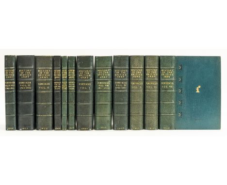
NO RESERVE Military.- Bindings.- Fortescue (Hon J.W.) A History of the British Army, 9 vol. only (of 14) and 3 vol. of maps only (of 6), together 12 vol., first editions, numerous folding maps, bookplates, g.e., handsomely bound in contemporary crushed blue morocco for William Henry Smith, signature in gilt inside lower covers, gilt, 1899-1917.⁂ Comprises of vols 1-8, vol. 4 in 2 parts, and map companions to vols. 4, 7 & 8.Provenance. Bookplate of William Henry Smith, Viscount Hambledon. Foyle copy with the Beeleigh Abbey bookplate.
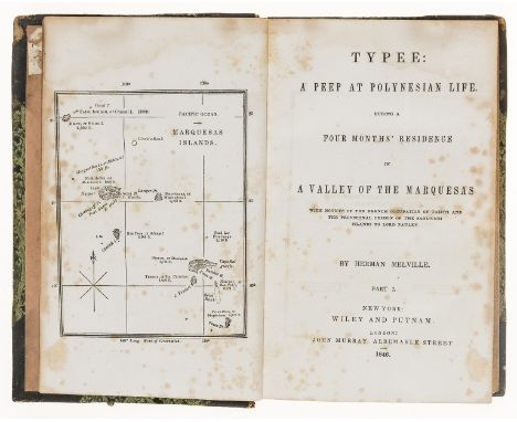
Polynesia.- Melville (Herman) Typee: a Peep at Polynesian Life During a Four Months' Residence in a Valley of the Marquesas, 2 parts in 1 vol., first American edition, map frontispiece, spotting, faint damp-staining, lacks advertisements, previous owner's ink signature, contemporary half-morocco, a little rubbed, 8vo, New York, Wiley and Putnam, 1846.
![Australia.- [Macarthur (James)] New South Wales; its Present State and Future Prospects, first edition, half-title, folding h](https://cdn.globalauctionplatform.com/9ff7d2ec-98fb-41a5-8315-ab8e00edfbf6/a27bd168-99d0-4394-9511-ab8e00f16da6/468x382.jpg)
Australia.- [Macarthur (James)] New South Wales; its Present State and Future Prospects, first edition, half-title, folding hand-coloured map, folding table, occasional spotting, bookplate and inscription of 'Delapré Abbey', original cloth, rebacked with original spine laid down, browned spine, bumping to corners, 8vo, 1837.
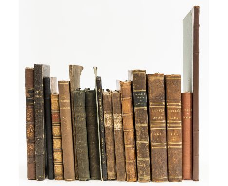
Addison (Joseph) Poems on Several Occasions with a Dissertation upon the Roman Poets, engraved portrait frontispiece and 2 plates, contemporary ink signature to front free endpaper, ink signature to title, contemporary panelled calf, rubbed, small loss to spine head, 1719 § Bowles (Rev. William Lisle) The Grave of the Last Saxon, 1822 bound before A Final Appeal to the Literary Public, relative to Pope ..., presentation inscription "John Montgomery Traherne from the Author, Jun 1st 1823," occasional faint spotting, bookplate, contemporary half-calf, a little rubbed, 1825 § Mickle (William Julius) The Lusiad; or, the Discovery of India, an epic poem, 2 vol., folding engraved map frontispiece, occasional spotting, previous owner's ink inscription, without half-titles, later half-calf, rubbed, 1798 § Southey (Robert) Poems, first edition, occasional faint spotting, modern cloth backed boards, 1797; and 13 others, poetry, v.s. (18)
![Russia.- [Plan of St. Petersburg], large folding lithographed map of St. Petersburg with hand-colouring, folds with repairs t](https://cdn.globalauctionplatform.com/9ff7d2ec-98fb-41a5-8315-ab8e00edfbf6/ee6d180a-8f4b-4df8-8f18-ab8e00f1c480/468x382.jpg)
Russia.- [Plan of St. Petersburg], large folding lithographed map of St. Petersburg with hand-colouring, folds with repairs to tears, original printed wrappers, browned, rather chipped and worn, rear cover detached, traces of restoration, s. петербургский, 1889; and another plan of St. Petersburg, dated 1817 § Sedillot (M.) Notice sur une carte routière de Meschhed à Bokhara et de Bokhara a Balkh, folding lithograph map with hand-colouring, paper wrappers, chipped, L. Martinet, Paris, 1852; together with Jourdier's De l'Émancipation des Serfs en Russie, lithograph map, stamps, some spotting, original printed wrappers, soiled, spine rubbed, Librairie A. Franck, Paris, 1861 (4)
![[Money (A. & George Henry)] Our Tent in the Crimea; and Wanderings in Sevastopol, presentation copy from the authors' mot](https://cdn.globalauctionplatform.com/9ff7d2ec-98fb-41a5-8315-ab8e00edfbf6/614267ca-21ee-4825-8e0e-ab8e00f0bbd5/468x382.jpg)
[Money (A. & George Henry)] Our Tent in the Crimea; and Wanderings in Sevastopol, presentation copy from the authors' mother to front pastedown, folding lithographed map, occasional light spotting, endpapers foxed, original blind-stamped cloth, soiled, spine a little faded, some pages unopened, 1856; and another, travel, 8vo (2)
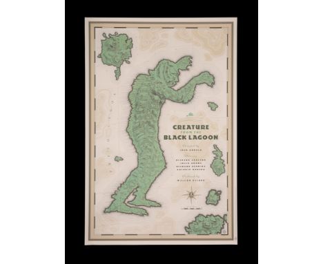
Something a bit different. A clever and innovative design by Laurent Durieux and a fresh take for the classic 'Gill-Man' Universal monster who makes regular appearances in the alternative 'Mondo' movie poster market. First offered for sale at the 'Mondotees' pop up stand at Fantastic Fest in 2012. It goes without saying, it sold out. Durieux's artwork for "Creature From the Black Lagoon" takes the form of a detailed ancient map with the the shape of the iconic 'creature' acting as an island. From an initial limited print run of 475 this is numbered #157.Hand-Numbered #157/47524" x 36" (61 x 91.5 cm)Condition: ExcellentUnrestored, rolled, flat and unfolded (as issued). Very minimal handling wear. It presents and displays to excellent effect.Artist: Laurent Durieux£100 - 200VAT Status: Ω


Dominique Bouhours (1628-1702): 'La vie de Saint Franois Xavier de la compagnie de JŽsus, apostre des Indes et du Japon', Paris, 1682--Ê4to: [16]-634-[10] pp., 1 folding map. Later half shagreen binding, marbl. paper on cardb. covers, spine with 5 raised bands.Ê Printed by SŽbastien Mabre-Cramoisy.Ê Ê -- Please request condition reports by e-mail on info@coronariauctions.com. They're being made on demand and added to the description on our website. High resolution pictures are also available on our website at www.coronariauctions.com. Further questions are always welcome at info@coronariauctions.com
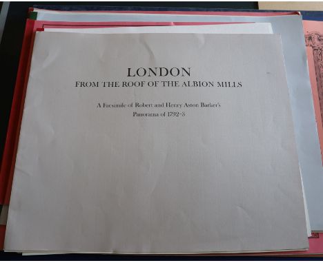
Nine facsimilies of early maps and panorama's: - 1. Ordnance Surveyor's Drawings of the London Area, 1799-18082. Rocque, John - A Plan of the Cities of London and Westminster, 17463. Morgan, William - London Actually Survey'd, 16814. The 'Rhinebeck' Panorama of London, c.18105. Kip, John - Prospect of London, 17206. A collection of early maps, 1553-16677. Ogilby, John - A large and accurate Map of the City of London8. Aston Barker, Robert and Henry - London from the roof of the Albion Mills, 1792-39. "Tribute to Sir Christopher Wren"All folios are complete.


Alexander, James Edward, Sir, 1803-1885 - Sketches in Portugal during the Civil War of 1834, 1st edition, 8vo, rebound, half blue morocco, with hand coloured frontis piece and engraved map, James Cochrane, LondonNote: The author is perhaps best known as having been the driving force behind the erection of Cleopatra's Needle.

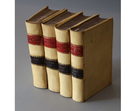
Lafitau, Rev. Pere, Joseph-Francois, 1681-1746. - Histoire des decouvertes et conquestas des Portugais, 4 vols, vellum, 8vo, folding engraved frontis panorama of Lisbon, and folding world map with small tears, and 14 folding plates, some worming in vols 3 and 4, Saugrain, Paris, 1733Note: A history of the Portuguese explorations of the 15th and 16th centuries. The World map delineates the voyages of Vasco da Gama, Cabral and Megallan


Sandys, George, 1578-1644. - Relation of a journey begun an: Dom: 1610 ... description of the Turkish Empire, 4th edition, calf, folio, pictorial title page, engraved by Francisco Delaram, with further illustrations in text, with vignettes and maps, including a folding double page map, bookplate of Geroge Dunn, Woolley Hall, Maidenhead, printed by [Thomas Cotes] for Andrew Cooke, London, 1637


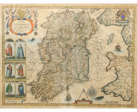
SPEED (JOHN), THE KINGDOME OF IRLAND DEVIDED INTO SEVERALL PROVINCES AND THEN AGAINE DEVIDED INTO COUNTIES NEWLY DESCRIBED, published Thomas Bassett & Richard Chiswell, hand coloured engraved map, six engraved costumed figures, ornate cartouche, mileage scale and compass rose, English text on verso. 42.5cm by 55cm

![Archer [J], coloured engraving, map of 'Westmoreland' from Dugdales and a 19th century map of Cumberland](https://cdn.globalauctionplatform.com/64a70903-b678-4794-ab5c-ab96009d50f4/2b3cfa87-3575-4e46-b2c2-ab9c0099777c/468x382.jpg)


Scarce Vintage Boxed Kenner Star Wars The Power of The Force Tatooine Skiff Vehicle, No 71540, in mint original condition, complete with 2 x rudders,2 x side rails, missing decal sheet, decals have not been applied, instruction leaflet, planetary map, with inner card packing, outer box is good, one end flap sellotaped closed, with some edge wear/creases, still a very nice example!


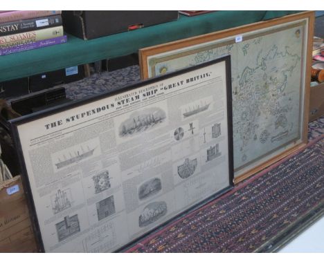
7x items of railwayana. A steel and cast iron cylindrical railway ticket punch machine painted green with plaque to top stamped A994. A small BR enamelled Distant semaphore signal (length 410mm). A British Railways enamelled armband, numbered 284. A Southern Railway wheel tapper's hammer. A section of Thanet Tramways rail. A cast iron plate numbered 325. Plus a framed map of the LSWR system. Generally GC for age. £60-80
-
109182 item(s)/page