We found 109182 price guide item(s) matching your search
There are 109182 lots that match your search criteria. Subscribe now to get instant access to the full price guide service.
Click here to subscribe- List
- Grid
-
109182 item(s)/page


Lot 232
John Evans, "The Juvenile Tourist: or Excursions into the West of England; into the Midland Counties, with part of South Wales; and into the Whole County of Kent; concluding with an account of Maidstone and its Vicinity. Interspersed with Historical Anecdotes and Poetical Extracts, for the Rising generation", London, 1818, 520pp, 12mo, map and frontis, publisher's cloth


![John Gibson (18th Century) [ Strip Map ] "A Correct Map of the Road from London to Carlisle, commencing at Darlafton (sic) Br](https://cdn.globalauctionplatform.com/370e947d-3c2d-41bd-ba5b-afc601098969/67f00fa6-b9c7-4f4d-91cb-afc700a5ac5c/468x382.jpg)
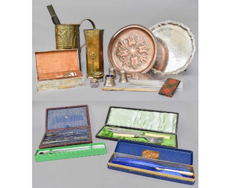
Lot 1182
John Gibson (18th Century) [ Strip Map ] "A Correct Map of the Road from London to Carlisle, commencing at Darlafton (sic) Bridge, in the Chester Road" including "The Road from Carlisle to Berwick", watercolour tinted engraving, circa 1700, in pen lined card mount and moulded gilt frame under glass, 43 cm x 33 cm overall


Lot 142
A Silver Cigarette Box, a silver topped glass toilet jar, a Keswick School of Industrial Arts brass vase, an Arts and Crafts brass jug, an Arts and Crafts copper charger, a Danish stainless steel cigarette box, an ATCO paper knife, a wood paper knife, a cased set of drawing instruments, a Tartan Ware calling card case, a cased pair of fish servers with ivorine handles and silver ferrules, a plated salver, a plated condiment set, a cake knife, a jam thermometer and a brass map reading magnifying lensSilver box with some minor corner dents. Jug with a re soldered handle. Brass vase with numerous dents. Many drawing instruments lacking. Tartanware case with notable wear to the edges. Wooden paper knife with loss to the terminal.
Lot 350
A Large Collection of Assorted Books and Empherma comprising, The Art Workers Quarterly, Vol I, No I, 1902; Sandoz, M., The House Without Windows, 1950, illustrated by Salvador Dali; Lanhgorne, D.A., Portrait of Iceland, 1943, illustrated by Óskar Bjarnason; Innes, T.A. and Castle, Ivor, Covenants with Death, 1934; also including British Museum Pictorial Cards printed by Waterlow & Sons Ltd; The Northern Broadsheet, Nos. 1 & 2, 1956 illustrated by Fred Lawson; A Railway Map of Yorkshire and Lancashire; Tales of Terror! or, More Ghosts: Forming a Complete Phantasmagoria; Counterpoint, Number One (front cover detached), etc. (qty)


Lot 2153
Chandler (Richard), 'Travels in Asia Minor: or an Account of a Tour Made at the Expense of the Society of Dilettanti', first edition, 4to, Oxford, Clarendon Press, 1775, folding engraved map, raised bands to spine with marbled boards (rebound).Condition Report: Clear wear to binding, including rubbing, cracking and fading to marbled boards. Internally in good condition, with limited foxing consistent with age. 5cm-long tear to corner of folding map.

Lot 2166
Amendment: Please note the new estimates for this lot. Emmanuel Bowen, Accurate Map of the County of Surrey Divided into its Hundreds, 53cm x70.5cm, framed and glazed, Emmanuel Bowen, Herefordshire, An Accurate Map of Hereford Shire divided into it's Hundreds........., printed for John Bowles & Sons. in Cornhill, T. Bowles in St. Paul's Churchyard, John Tinney & Robt. Sayer in Fleet Street, circa 1760, 58cm x 76cm, framed and glazed, Robert Morden, Northampton Shire, hand coloured circa 1695, 36cm x 42.5cm, framed and glazed. (3)

Lot 2165
Amendment: Please note the new estimates for this lot. Christopher Saxton / William Kip map of Bedford, Bedford Comitatus olim Pars Cathifuclanorum, circa 1637, hand coloured, 28cm x 34.5cm, framed and glazed, Christopher Saxton / William Kip map of Dorset, Dorcestriae Comitatis Vulgo Dorsett Ubi Olim Durotriges Insederunt, circa 1637, hand coloured, 28cm x 39cm, framed and glazed,


Lot 2406
Royal Airforce: Autograph Album signed by Guy Gibson, James Edgar Johnnie Johnson and other pilots, c. 1943; with an Original Leather Jerkin and related books - A pressed leather bound autograph album containing nine signatures, a typed ownership label to front pastedown reads Alan K. Bridewell, Godalming, Surrey, Squadron 1254 Air Training Corps, most autographs signed on a single page (a few with pencil sketches) include J.M. Beagby, Sgt./pilot, with a list of aircraft he had flown beneath, Guy Gibson, signed in blue ink and dated 21/2; Jean E. Caesar, G.T.C. dated December 11, 1943; Squadron Leader M.N. Namkins DFC., No.15 Heavy Bomber Squadron; A.G. Turley, dated July 11, 1943; E. Hardz? P/O., Ex 1254 Squadron ATC., dated 10/12/43; Organist, Reginald Foort, with a hand-written drawing of a music score above; B. Aikens. R.N.V.R.; two autographs are signed on the same page, the first dedicated to Alan and signed by Johnnie Johnson, W/Comdr., the second signature reads, J. Baldwin, DSO. & Bar, DFC. & Bar, DFC. (USA) Spitfire Pilot. 26 e/a., ? possibly Wing Commander John Robert Baldwin; a loosely inserted newspaper cutting, the article headed Portrait of a Bader Pupil, signed by J.E. Johnson; with numerous other newspaper cuttings loosely inserted, including several relating to the imminent release of Wing Commander Douglas Bader from Colditz prisoner-of- war camp in April 1945; Original Military WWII Tan Leather Jerkin, the leather made up of separate panels as per WWII austerity measures, four matching brown buttons to front and original green serge lining, no label present, Chest 21 ¾ inches, Shoulders 17 ¼ inches, Length 30 inches; a burgundy and navy-blue striped scarf, labels read, Silk Wert, Rayon Warp, Made in England; together with three related books including GIBSON (Guy). Dambusters! The inside story of the most famous bombing raid of WWII, Manchester, Crecy Publishing, 2014, second edition; Air Navigation Stages One & Two Notes for Students, Air Ministry 1944, with 'Effect of Visibility on Map Reading circular paper sheet loosely slipped in between pages; Learn A Trade in the Royal Airforce, Air Ministry [c. 1944] (6)Wing Commander Guy Penrose Gibson, VC., DSO & Bar, DFC. & Bar (1918-1944) was the first Commanding Officer of 617 Squadron which he led in May, 1943 during Operation Chastise. better known as the Dam Busters raid. Gibson was awarded the Victoria Cross for gallantry and became the most highly decorated British serviceman at that time. He completed over 170 war operations before he was killed in action at the age of 26. Air Vice Marshal James Edgar Johnson, CB., CBE., DSO. & Two Bars, DFC, & Bar, DL. (1915-2001) nicknamed Johnnie, was an English Royal Airforce pilot and the highest scoring Western Allied fighter ace against the German Luftwaffe. Johnson served in the Korean War before retiring in 1966 with the rank of Air Vice Marshal.Wing Commander John Robert Baldwin, DSO. & Bar, DFC. & Bar, AFC. (1918-1952) was a Royal Airforce fighter pilot and top scoring fighter ace who also flew Hawker Typhoon during WWII. He went missing during secondment service with the United States Airforce in the Korean War and was presumed killed.1254 Squadron, serving the Godalming and Guildford areas, was one of the first Air Training Corps established in 1941. No. 15 Squadron was first formed at Farnborough Airfield as a Royal Flying Corps training unit, March 1, 1915. The heavy bomber squadron were one of the first to fly the Stirling four engine bomber aircraft, later converting to Avro Lancasters in 1943.Reginald John Foort (1893-1980) was a cinema and theatre organist.


Lot 31
Paradise.- Syria.- Ortelius (Abraham) Daphne, wooded paradise with temple dedicated to Apollo, currently situated in modern-day Syria, close to the Turkish border, engraved map with original hand-colouring, on laid paper with watermark of crossed arrows, platemark 365 x 490 mm (14 1/4 x 19 1/4 in), sheet 440 x 550 mm (17 1/4 x 21 1/2 in), Latin text verso, surface dirt and browning, mainly visible to margins, repairs to central vertical fold, handling creases, unframed, [circa 1590].

Lot 40
NO RESERVE England.- Roscoe (Thomas) The Book of the Grand Junction Railway, hand-coloured folding map frontispiece, additional engraved title, 15 engraved plates, 3 lithographed plans, scattered spotting, occasional faint marginal staining, original cloth, rebacked retaining original backstrip, gilt, g.e., slight bumping to corners and extremities, 8vo, [1839].
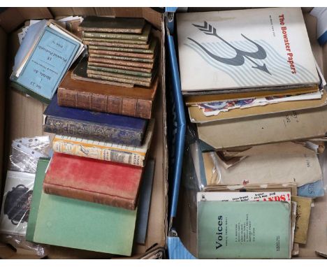
![Northumberland.- Archive of documents relating to Northumberland, including: A Plan of Bolton Estate [&] A Plan of Brunto](https://cdn.globalauctionplatform.com/2ccb5b15-4468-460a-a3aa-afc100bb15b2/836b8ab5-8c39-46e0-af6c-afc100c5ee14/468x382.jpg)
Lot 142
Northumberland.- Archive of documents relating to Northumberland, including: A Plan of Bolton Estate [&] A Plan of Brunton Estate, estate map of Bolton and Brunton estates, pen and ink map, hand-coloured in outline, with pen letterpress of fields, on vellum, slightly yellowed and creased, c. 790 x 760mm., n.d. [c. 1815]; and 15 documents relating to Northumberland, most on vellum, some on paper, folds, housed in a custom box, v.s., 1814-42 (16 pieces).
Lot 41
Hertfordshire.- Chauncy (Henry) The Historical Antiquities of Hertfordshire, first edition, title printed in red and black, engraved portrait of the author and folding map by Moll, 40 engraved views, towns and plans only (of 44), most double-page, lacking Directions to Binder leaf at end, James Lees-Milne's copy with his bookplate, another owner's ink inscription to front free endpaper, 3 loosely inserted newspaper clippings relating to the sale of properties in the text, plate at 2H1 with contemporary ink drawing verso, folding map and 5 plates with portions of loss at fore-edge (reinforced with paper), plate at L4 with larger portion torn away and replaced with later paper, some other minor repairs, mostly marginal, affecting text at 2R3 and 4K2, some foxing or browning, bound in olive morocco by R.H. Porter, gilt, spine and extremities sunned, spotting and marking to covers, [Wing C3741], Printed for Ben. Griffin [& others], 1700; with a 3 vol. set of Cussans' History of Hertfordshire, folio (4)
Lot 1
Afghanistan.- Elphinstone (Hon. Mountstuart) An Account of the Kingdom of Caubul, and its dependencies in Persia, Tartary, and India, first edition, errata leaf, preliminaries misbound, engraved map hand-coloured in outline, 13 aquatint plates only (of 14, lacking plate 13), 12 hand-coloured, also lacking folding map, some foxing, a few stains, signature cut away from upper outer corner of title, bookplate of Richard Chute, contemporary half calf, rubbed, corners worn, rebacked with gilt spine, [Abbey, Travel 504], 4to, 1815.
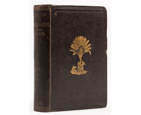
Lot 2
NO RESERVE Africa.- Ellis (Rev. William) Three Visits to Madagascar during the years 1853-1854-1856, first edition, half-title, folding wood-engraved frontispiece, 14 plates, 1 engraved map, 1 additional large colour map loosely inserted, one or two short tears to folds, illustrations, 32pp. publisher's advertisements at end, ?new endpapers, original decorative cloth, recased, neat repairs to spine extremities, slight bumping to corners, 8vo, 1858.

Lot 45
London.- Wyld (James) Plan of the Districts Drained by Water Courses Discharging into the River Thames, between the City of London and the Parish of Fulham..., large engraved wall map, extending from Hampstead Heath in the north to Lincoln's Inn Fields in the east, Chelsea in the south, and Shepherd's Bush Green in the west, showing "Open Watercourses", "Main Sewers", "Boundaries of the the District drained by these Sewers", and "Boundaries of Parishes", 1270 x 980 mm (50 x 38 1/2 in), mounted on linen, varnished, wooden rollers to upper and lower edges, handling creases and surface dirt, some losses, nicks and tears, rolled, 1834.⁂ Scarce. We can trace just one later issue ("With Corrections to 1840 and 1844") at the London Metropolitan Archives.
Lot 222
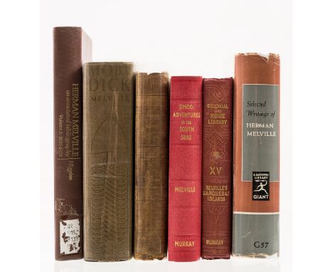
NO RESERVE Melville (Herman) Omoo: A Narrative of Adventures in the South Seas, first edition, map frontispiece, contemporary ink ownership name to front free endpapers, these reinforced at hinge, original red cloth, rebacked, a little rubbed and corners bumped, [BAL 13655], 1847; Narrative of a Four Month's Residence Among the Natives of a Valley of The Marquesas Islands, first edition, map, 16pp. publisher's catalogue at end dated March 1846, original first issue cloth, binding variant A, expertly rebacked, light bumping to corners, light surface soiling, [BAL 13652], 1846; and 4 others, Melville, 8vo (6)
Lot 65
Botany.- Plant-hunting.- Veitch (James Herbert) A Traveller's Notes or Notes of a Tour through India, Malaysia, Japan, Corea, the Australian Colonies and New Zealand during the years 1891-1893, first edition, folding map, 9 photogravure plates with tissue guards, illustrations, foxing to plates and guards, original pictorial cloth, rubbed, spine browned and a little worn at ends, 4to, privately printed, 1896.⁂ Tour by the famous nurseryman in search of plants.

Lot 175
Roman Britain.- Antoninus (Augustus) Iter Britanniarum, commentary by Thomas Gale, folding engraved map with repaired tear, 2 plates, illustrations, 5pp. advertisements at end, upper inner corner of title repaired, occasional foxing and browning, later blind-stamped calf, rebacked, 4to, M. Atkins, 1709.
Lot 36
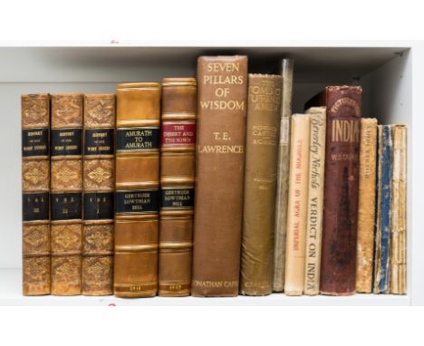
NO RESERVE World.- Bell (Gertrude) The Desert and the Sown, first edition, frontispiece, plates, and large folding map, occasional light spotting, modern half calf, 1907; Amurath to Amurath, first edition, plates, light finger-soiling and foxing, modern half calf, 1911 § Edwards (Bryan) The History Civil and Commercial of the British Colonies in the West Indies, 3 vol., third edition, frontispiece to vol.1, bookplates to pastedown, light foxing, contemporary half calf, lightly rubbed, for John Stockdale, 1801; and 9 others, travel, v.s. (14)
Lot 39
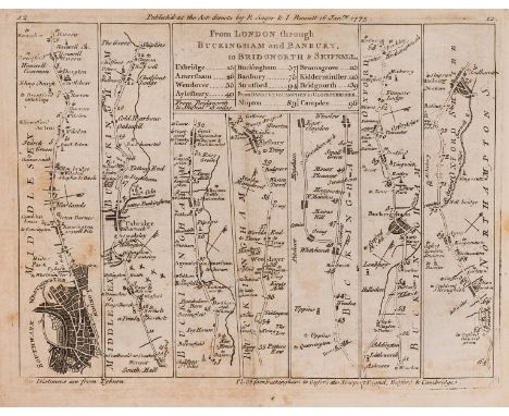
Britain.- Senex (John) Jefferys's Itinerary; or Travellers Companion, through England, Wales, and Part of Scotland, letterpress title, preface and index, engraved general map and 104 strip maps, title and a few maps with small repairs, general map trimmed, some light foxing and browning, modern cloth, oblong 4to, Printed for R. Sayer and J. Bennett, 1775.

Lot 29
Middle East.- Burckhardt (John Lewis) Travels in Arabia, 2 vol., second edition, engraved folding map and 4 folding plans, scattered spotting, lacking half-titles and final advertisement f., bookplate, near contemporary half-calf, a little rubbed, slight bumping to corners and extremities, [Blackmer 239], 8vo, 1829.⁂ Burckhardt travelled to Mecca and Medina in 1814 disguised as an Arab Sheikh and through his extensive knowledge of Arabic and Muslim practices managed to avoid exposure.
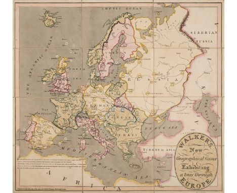
Lot 15
Darton (William, Jr. & Thomas Darton, publishers) Walker's New Geographical Game, Exhibiting a tour through Europe, engraved map with original hand-colouring, 455 x 500 mm (17 7/8 x 19 3/4 in), dissected and mounted on linen, with light surface dirt and browning, folding into the marbled paper slipcase, with engraved title label, corners rubbed, slightly worn, published for the author by W. & T. Darton, 1810.
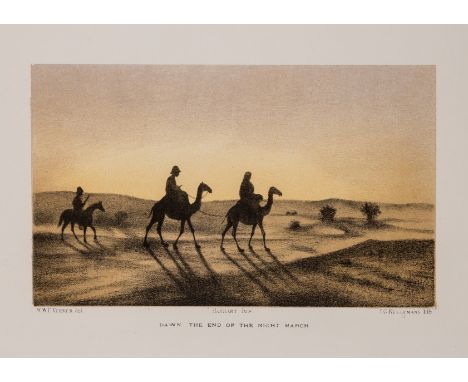
Lot 7
Africa.- Verner (Capt. Willoughby) Sketches in the Soudan, first edition, additional lithographed pictorial title, list of subscribers, 39 chromolithographed plates on 37 sheets by J.G.Keulemans after Verner, each with facing explanatory leaf of text, chromolithographed map, advertisement leaf at end, some light foxing, original pictorial boards, rubbed, corners a little worn, rebacked in cloth, oblong folio, 1885.⁂ The artist served in the Rifle Brigade, D.A.A.G. Intelligence Department, Nile Expeditionary Force of 1884-85 which was an attempt to relieve General Gordon besieged in Khartoum by the rebellious Mahdi. The expedition travelled up the Nile in small adapted whalers, aided by Canadian voyageurs to negotiate the rapids, and were attacked by the rebels at Abu Klea and Abu Kru but managed to continue. They finally reached Khartoum in January 1885, two days after Gordon and the garrison had been massacred. As well as scenes of the Nile, the desert, and the battlefields & military engagements, there are more everyday sketches of bivouacs and camps, finding water in the desert, and portraits of those involved.

Lot 23
India.- Wyld (James) Hind, Hindoostan, or India By L.S. de la Rochette ..., detailed map of the Indian continent including Sri Lanka and the Maldive Islands, with jungle vignette featuring an elephant surrounding the title cartouche in the lower right corner, engraved map with hand-colouring, platemark 710 x 540 mm (28 x 21 1/4 in), good margins, under glass, central horizontal fold as issued, some faint toning to sheet and minor areas of discolouration, minor spotting and surface dirt, framed, 1832; together with a framed lithograph by Arthur Wallis after James Lambert of Brighthelmston, Isle of Wight, a framed and trimmed impression of 'The Tsunami of Pool Valley, Brighton, during the Thunderstorm of Wednesday, July 17th 1850', by R. Canton after J. Leathem and J. Watkins, and a framed silk embroidery of ducks, all framed, [19th century] (4)
Lot 27
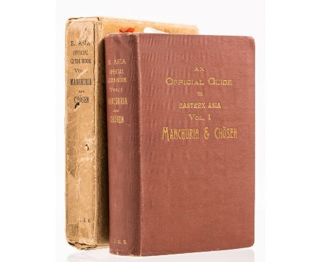
Korea.- Official Guide to Eastern Asia: Trans-Continental Connections Between Europe and Asia (An), vol.1 Manchuria & Chosen, first edition, illustrations, large folding colour maps including fold-out map inserted into rear pocket, edge-spotting, original cloth, t.e.g., light creasing or rubbing to spine ends, original slipcase, 8vo, Tokyo, prepared by the Imperial Japanese Government Railways, 1913.⁂ Beginning in 1871, Japan began to exert more influence in Korea, forcing it out of China's traditional sphere of influence. As a result of the sino-japanese war (1894-95), the Qing Dynasty had to give up such a position according to article 1 of the Treaty of Shimonoseki, which was concluded between China and Japan in 1895. This work attests to a statement of Japanese pride in their recently conquered mainland territories.

Lot 44
London.- Lucas (George Oakley) Plan of the Borough of St. Mary-le-Bone, comprising the Parishes of Paddington, St. Mary-le-Bone & St. Pancras, in the County of Middlesex, large engraved wall map with hand-colouring, 1140 x 1170 mm (43 7/8 x 46 in), mounted on linen, varnished, with wooden rollers to upper and lower edges, discolouration and browning to varnish, handling creases, some splitting, surface dirt, rolled, published by Ch[arle]s Haselden, 21, Wigmore St. Cavendish Square, 1850.⁂ Scarce, we can trace no other institutional examples.
Lot 37
NO RESERVE World.- Cook (Captain James) Troisieme Voyage Abrégé du Capitaine Cook, dans L'Océan Pacifique, 3 vol., folding frontispiece to vol. one, title to each volume with "L.B." ink ownership inscription to each, slightly spotted, endpapers creased and stained, contemporary mottled calf, rubbed at extremities, small gouge to spine head, Paris, 1785 § Crawfurd (James) History of the Indian Archipelago, 3 vol., each with frontispiece, engraved plates, one in colour, vol. 3 with folding map supplied in later facsimile, bookplate, inkstamp to verso of each title, light offsetting, some browning and ink inscriptions to endpapers, half marbled calf, worn at extremities, Edinburgh, 1820 § Encyclopaedia Britannica, vol. 1-32 only (lacking vol. 6, 7 and 8), mixed edition, folding maps, photographic plates and illustrations, some coloured, endpapers browned, original cloth, lightly rubbed at extremities, 1910-22; with c.30 others relating to travel, science, art and music, v.s., (70)
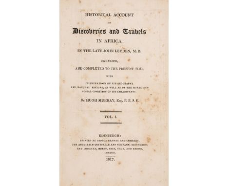
Lot 4
Africa.- Leyden (Dr. John) Historical Account of Discoveries and Travels in Africa, edited and enlarged by Hugh Murray, 2 vol., first edition, engraved large folding frontispiece map and 5 other maps, 2 folding, large folding map reinforced with paper verso, others trimmed, some light foxing, modern half calf, black morocco spine labels, new endpapers, Edinburgh, 8vo, 1817.
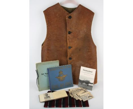
![India.- [Maurice (Thomas)] Indian Antiquities: or, Dissertations, relative to ... Hindostan, 7 vol., folding engraved frontis](https://cdn.globalauctionplatform.com/2ccb5b15-4468-460a-a3aa-afc100bb15b2/cd628c7a-fdfa-442f-8752-afc100c443f7/468x382.jpg)
Lot 22
India.- [Maurice (Thomas)] Indian Antiquities: or, Dissertations, relative to ... Hindostan, 7 vol., folding engraved frontispieces, 23 engraved plates, 21 folding, hand-coloured folding map, short marginal tear, list of subscribers, scattered spotting and staining, 2F8 vol. 4 with hole through text without loss, I3 vol. 3 with small marginal loss, contemporary calf, slight bumping to corners and extremities, 8vo, 1793-1800.
-
109182 item(s)/page