We found 109182 price guide item(s) matching your search
There are 109182 lots that match your search criteria. Subscribe now to get instant access to the full price guide service.
Click here to subscribe- List
- Grid
-
109182 item(s)/page


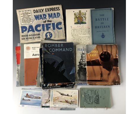
Lot 307
An interesting set of five hard cover booklets containing long fold out panoramic reconnaissance photographs of the Eastern section of the D-Day coastline, from Trouville to Port-en-Bessin, dated from January to March 1944, the front covers marked "Booklet A" to E, "France North Coast", with details of the relevant Admiralty Charts and G.S.G.S maps of the area, and stating that the photographs were "taken at zero feet and at right angles to the coast: distance off shore about ½ to ¾ mile", and that they were intended as an air to coastal recognition and are NOT intended for navigational purposes", the back covers with outline map of the coast from Cap de la Hague to Le Havre showing the sections covered by each booklet plus further sections from F to S, booklet B also contains "Top Secret Appendix" showing an outline of the "Juno Area Annexe A" beach with additional information regarding underwater obstacles up to 19th May 1944. Generally GC (some water staining to covers suggesting that they were used for their intended purpose, some parts of the photographs detached).


Lot 7435
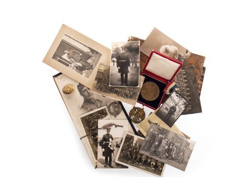
Photograph/scrap album of the King~s African Rifles^ 1942-1946^ including campaign map^ brochures^ newspaper cuttings^ many black and white photographs incluing troops^ portraits^ villagers^ tribal dances^ mule camps^ boat building^ railway stations and trains^ Kilidini docks. Each album has approximately 100 pages^ with at least 2 photos per page^ some pages may have brochures^ maps^ leaflets^ postcards and locally bought photographs too.¦

Lot 74
Stanford's Library Map of London and its Suburbs. 24 Sheets, On the Scale of Six Inches to a Mile, Lympne Castle; Harry Margary, 1980, introductory notes by Ralph Hyde, large oblong folio, together with A Large and Accurate Map of The City of London, Ichnographically Describing all the Streets, Lanes, Alleys, Courts, Yards, Churches, Halls and Houses &c. Actually Surveyed and Dilineated. By John Ogilby Esq. His Majesties Cosmographer, Lympne Castle: Harry Margary, 1976, intoductory notes by Ralph Hyde, facsimile of the Greater London Council copy from the 1676 survey, 20 maps, oblong folio. (2)
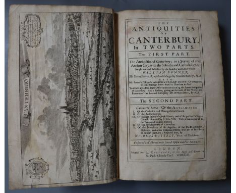
Lot 102
CANTERBURY: Somner, William and Battely, Nicholas - The Antiquities of Canterbury, in two parts, the first part, The Antiquities of Canterbury; or a Survey of that Antient City, with suburbs and Cathedral, etc, the second part, Cantuaria Sacra: or The Antiquities Illustrated and Adorned with Several Useful and Fair Sculptures, the second edition, revised and enlarged, tall 4to, old leather scuffed and work, rebacked, with a folding map of Canterbury and 18 additional plates, 4 of which fold out, R. Knaplock, London 1703, S.R. for Samuel Keble, London 1686 printed in Latin and English and Hildyard, John; Dart, John and Drake, Francis - An Accurate Description and History of the Metropolitan and Cathedral Churches of Canterbury and York, from Their First Foundation to the Present Year, folio, calf rebacked, illustrated with 117 copper plates, 82 full page plates, W. Sandby, London 1756, S.R. for Samuel Keble, London 1686 printed in Latin and English
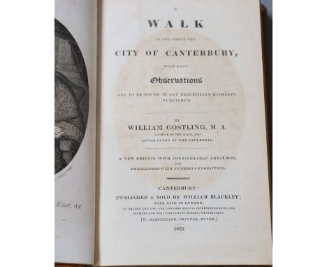
Lot 104
CANTERBURY: Gostling, William - A Walk in and about the City of Canterbury, New edition, 8vo, modern calf, with frontis and folding map, Canterbury 1825 and Woolnoth, William - A Graphical Illustration of the Metropolitan Cathedral Church of Canterbury, Accompanied by History and Description, 1st edition, qto, half calf, front cover and first few pages detached, 22 plates, some stained, Cadell, Davies and Murray, London 1816

Lot 105
Lambard, William - A Perambulation of Kent, 8vo, original green cloth, spine torn and with loss, boards damp stained, front joint split and badly repaired, Chatham 1826; Henshall, Samuel - Specimens and Parts: containing a History of the County of Kent ..., 4to, half calf, with double page folding map, London 1798 and Malcolm, James Peller - Excursions in the Counties of Kent, Gloucester, Hereford, Monmouth and Somerset in the Years 1802, 1803 and 1805, 2nd edition, 8vo, with engraved title and 22 plates, London 1813

Lot 107
Grose, Francis - The Antiquities of England and Wales, Vol 3 only, 4to, tree calf, boards detached, text and plates spotted, with folding map of Dover Castle, Hooper and Wigstead, London [1886?]; Oulton, Walley Chamberlain - The Traveller's Guide; or, English itinerary; containing accurate and original descriptions of all the counties, cities, towns, villages, hamlets, &c. and their exact distances from London, 2 vols, 12mo, calf, rebacked red leather, with 66 engraved views, map of England and Wales inserted in vol I, James Cundee, London 1805; Cooke, George A and Brewer, J.N. - Walks Through Kent; Containing a Topographical and Statistical Description of the County, and of the Isle of Thanet, in Particular. To Which is Prefixed a Copious Travelling Guide Exhibiting the direct and principal Cross Roads, Inns, Distances of Stages, 12mo, quarter morocco, folding map and 20 full page engraved plates, Sherwood, Neely and Jones, London 1819 and Bagshaw, Samuel - History, gazetteer, and directory of the county of Kent, comprising a general survey of the county and the sees of Canterbury and Rochester, 2 vols, 12mo, embossed maroon cloth, folding coloured map in vol 2, Sheffield 1847
Lot 109
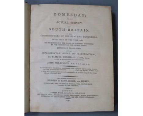
Henshall, Samuel and Wilkinson, John - Domesday, or an actual survey of South - Britain, by the Commissioners of William the Conqueror, completed in the year 1086 ... Counties of Kent, Surrey and Sussex ..., qto, half calf, double page map, Bye and Law, London 1799; Dearn, Thomas, Downes Wilmot - An historical, typographical and descriptive account of the Weald of Kent, rebound in a half leather with marbled boards and 7 (of 8) sepia aquatint views and map, lacks plate of Cranbrook High Street, S. Reader, Cranbrook 1814 and Kilburne, Richard - A Topographie or Survey of the County of Kent, with Some Chronological, Historicall, and Other Matters Touching the Same; and the Several Parishes and Places therein, small qto, suede, lacks frontis portrait, Thomas Mabb, London 1659

Lot 112
ROCHESTER: Thorpe, John - Registrum Roffense: or, A collection of antient records, charters, and instruments of divers kinds, necessary for illustrating the ecclesiastical history and antiquities of the Dioceses and Cathedral of Rochester, folio, rebound red half cloth, London 1769; Rawlinson, Richard - The History and Antiquities of the Cathedral Church of Rochester, in two parts, 8vo, calf, front board detached, E. Curll, London 1717 and Shrubshole, William - The History and Antiquities of Rochester and Its Environs, 8vo, calf, folding map as frontispiece, and 5 plates, blindstamped, front board detached, T. Fisher, Rochester 1772


Lot 119
MARGATE: Keate, George - Sketches from Nature Taken and Coloured in A Journey to Margate Published From The Original Designs, 5th edition, 8vo, paper covered boards and spine, joints very weak, loss to spine, early 19th century ink writings to early pages, J. Cundee, London 1802; RICHBOROUGH: Battely, John - The Antiquities of Richborough and Reculver. Abridged from the Latin, frontispiece map and 1 plate only (of 8), half calf, spine and joints split, boards scuffed, J. Johnson, in St Paul's Church-Yard, London 1774 and DEAL: Pain, Edward Charles - History or Deal (1914-1953), 8vo, blue cloth (faded), illustrated by [42] plated and by photographs and drawings, T.F. Pain and Sons Ltd, Deal 1953, together with Clarke, E.W. - Reminiscenses of Old Deal, oblong qto, original green cloth, T.F. Pain and Sons Ltd, Deal, [c.1950]

Lot 121
Kent - Excursions in the County of Kent, 8vo, blind stamped morocco gilt, with 50 engravings and 2 folding maps of Kent and Canterbury, each with small tears, maps and plates spotted and darkened throughout, London 1822; Cooke, George Alexander - Topographical and Statistical Description of the County of Kent, 12mo, with folding map, calf joints split, spine cracked and with loss, London [c.1800] and Miller, William - Jottings of Kent, being a Series of Historical, Ecclesiastical, Topographical and Statistical Sketches, 3rd edition, illustrated paper covered boards, Thomas Hall, Gravesend 1871 together with Rambles in Kent, 8vo, embossed boards, illustrated with 62 engravings on wood and 6 elegant steel plates, J. Mead, London [c.1845]


Lot 559
Collection of seven Framed and Glazed Antique Maps of Middle East including Syria & Assyria and Macedonia, Libyam & Indiam both published by R Wilkinson 24cms x 30cms; Arabia with Egypt, Nubia & Abyssinia 33cms x 40cms; Map of Ancient Egypt 23cms x 21cms; Arabia agreeable to modern history by H Moll 21cms x 27cms; New Map of Arabia by Robert Morden 14cms x 16cms; Map of Asia Minor 20cms x 27cms


Lot 109
Lake District Martineau, Harriet. The English Lakes. Simkin, Marshall & Co., 1858. 4to, org cloth; 6 plates, 6 mountain outlines, 45 woodcuts to text, colour folding map (poss. lacking 2 colour plates) Payn, James The Lakes in Sunshine. Windermere: J. Garnett, 1867. 4to, org. cloth; 16 mounted albumen photographic prints with two others [4]. Additional books Abraham, A.P. Beautiful Lakeland and Abraham, G.P. The English Lakeland.

Lot 112
Atlases Hall, Sidney & Hughes, William General Atlas of the World. Edinburgh: A. & C. Black, 1854. Folio, half black leather; 75 of 77 maps (lacking I (The World) and XLV (North America)) but with additional Schenk and McFarlane, Chart of the Baltic bound-in after XXVII-VIII (Russia in Europe) and map of South America laid down opposite LI (South America). Blackie, W.G. The Comprehensive Atlas & Geography of the World. Blackie & Son, 1884. Folio, half leather; 10 coloured illus of Peoples of the World, 67 coloured maps, illus to text. Bartholemew, J.G. Citizen's Atlas of the World. w.a.f.. Bindings all worn, Hall marginal toning, some fraying of edges, a little dusty and foxed, Blackie upper hinge cracked, stain to foredges, variable foxing, Bartholomew w.a.f.

Lot 113
Capper, Benjamin Pitts A Topographical Dictionary of the United Kingdom. George B. Whittaker, 1826. 8vo, leather-backed boards; 46 maps (Wales one folding map as not uncommon). Lewis, Samuel Topographical Dictionary of England. Atlas only. S. Lewis & Co., 1831. 40 maps between boards. Gazetteer of Scotland, 7 vols (original parts), Fullarton, 1847, with another copy bound in 2 and Census Atlas of South Yorkshire, U. of Sheffield, 1973. [12]
![Blaeu, Willem Scotia Regnum. Amsterdam: Willem Blaeu, [c.1635.] Hand-coloured, framed and glazed.. A touch toned, noticeable](https://cdn.globalauctionplatform.com/28629d45-ecb0-4187-8b9b-aa3100cc0976/53978651-0d8f-4405-b11e-aa5e01038c84/468x382.jpg)
Lot 116
Blaeu, Willem Scotia Regnum. Amsterdam: Willem Blaeu, [c.1635.] Hand-coloured, framed and glazed.. A touch toned, noticeable central crease from atlas, slight marginal foxing occasionally affecting image, small paint mark to left of map, restoration to central fold on verso, no obvious tears, very good.

Lot 117
Rocque, John England and Wales Drawn from the most accurate Surveys - containing all the Cities, Boroughs, Market Towns and Villages; in which are included all the improvements and observations both astronomical and topographical, which have been made by members of the Royal Society & others. Down to the present year, the whole corected & improv'd by John Rocque, Chorographer to his Majesty. Robert Sayer, Map and Printseller at the Golden Buck, at Fleet Street, [c.1780]. Two sheets, hand-coloured in outline.. Some offsetting where map folded, marginal browning, a little creased and chipped to edges, but very good.

Lot 118
Cary, John A New Map of England and Wales with part of Scotland. J.Cary, 1794. 4to, bound in leather-backed boards, sometime rebacked; eng. title and dedication, general map and explanation, 77 maps hand-coloured in outline (as not uncommon lacking sheets 62, 71, 72, 80, all sea sheets), occasional MSS annotations to margins in ink and pencil. Cary, John Cary's New and Correct English Atlas being A New Set of County Maps from Actual Surveys. Printed for John Cary, 1793. 4to, sometime bound in calf-backed marbled boards; 47 maps hand-coloured in outline (all but one browned, possibly stained).. New Map original binding worn but tight, some marking and offsetting internally, some page edges a little worn or frayed, but very good. Atlas binding a little rubbed at extremities, 46 maps oddly toned or stained.
![Stingemore, Frederick H. Underground Railways of London. Waterlow and Sons, [c.1926] Card folded twice, interior map with lis](https://cdn.globalauctionplatform.com/28629d45-ecb0-4187-8b9b-aa3100cc0976/9b87a87e-c6bd-44f7-9ae9-aa5e01038e16/468x382.jpg)
Lot 120
Stingemore, Frederick H. Underground Railways of London. Waterlow and Sons, [c.1926] Card folded twice, interior map with lists of theatres and places of interest on verso, one map with teal cover, one with yellow. Two Tube maps from the period of redesign embarked upon to simplify the experience of reading the Underground map. Stingemore compressed the outer lines in order to give space for the congested centre, but continued the ingrained habit of treating a map as geographically reflective. It was not until Harry Beck's breakthrough map of 1933 that the map would cease to be the territory. This version was though highly successful, passing through 11 editions between 1925 and 1932. These examples must date from post-1926 as they show the Morden extension as complete and must be at least third editions, as they show the River Thames. This was not present on the first two versions, but traveller confusion seems to have led to its inclusion. With three other 1961 London Transport maps. [5]. A little foxing to the creases and some wear to outer panels on both older maps but very good. Later three used but good.
![Speede, John Lancaster, uncoloured map; with Caernarvon, coloured, both framed and glazed (Caernarvon single-sided). [2]. Lan](https://cdn.globalauctionplatform.com/28629d45-ecb0-4187-8b9b-aa3100cc0976/1b9dba05-bbb3-430e-ad42-aa5e01038ea4/468x382.jpg)
Lot 122
Speede, John Lancaster, uncoloured map; with Caernarvon, coloured, both framed and glazed (Caernarvon single-sided). [2]. Lancaster toned with a little spotting to lower margin, creasing round central fold with strengthening on verso but no obvious tears or similar. Caernarvon toned with a little creasing.
![Jansson, Jan Ducatis Eboracensis Pars Borealis. The North Riding of Yorkshire. Amsterdam, [1646]. Hand-coloured in outline an](https://cdn.globalauctionplatform.com/28629d45-ecb0-4187-8b9b-aa3100cc0976/a2ea6e1a-4a08-4ca1-bf2c-aa5e010392ca/468x382.jpg)
Lot 130
Jansson, Jan Ducatis Eboracensis Pars Borealis. The North Riding of Yorkshire. Amsterdam, [1646]. Hand-coloured in outline and wash, framed and glazed double-sided, Latin text on verso.. Noticeable central crease, slight foxing and a little dusty, tape repair to head of crease on verso (likely short tear, affecting map).

Lot 131
Hobson, William Colling This Map of Yorkshire, is Most Respectfully Dedicated to the Nobility, Clergy, Gentry, Landowners and Manufacturers of the County, Sept. 1843. Four sheet reduction of Hobson's nine sheet map of 1828.. Marginal creasing and fraying to all sheets, margins dusty, some suggestions of water-staining, more pronounced to right side of two sheets.

Lot 132
Teesdale, Henry & Stocking (C.) To the Nobility, Gentry & Clergy of Yorkshire, this Map of the County constructed from a Survey commenced in the Year 1817, & corrected in the Years 1827 & 1828, is respectfully dedicated by the Proprietors, April 21,1828. 8 sheets of 9 (lacking lower right corner with vignette) with additional hand-coloured title sheet (top right), loosely between boards Kitchin, Thomas An Accurate Map of the Country Palatine of Durham, c.1751, hand-coloured in outline, mounted.

Lot 137
Henderson, Ebenezer Iceland or the Journal of a Residence on that Island during the years 1814 and 1815. Edinburgh: Printed for Oliphant, Waugh and Innes, 1818. 8vo, contemporary full calf, spines with contrasting morocco lettering-pieces; pp. I: lxi, [2], 377, II: vii, [1], 412; 1 folding map, hand-coloured in outline, 15 plates; provenance: ex-George Heriot's Hospital (gilt number and name on spines, stamps on title-pages and headers of Chaps I and X). First edition.. Bumping to board edges, a little scuffing to spines with slight loss of leather, some variable foxing to plates, but text generally clean.
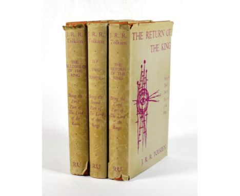
Lot 45
Tolkien, J.R.R. The Lord of the Rings Trilogy. George Allen & Unwin, 1960. 8vo (3 vols). Org. cloth in unclipped jackets; folding map in rear of each volume. Readers Union edition, not for general sale.. Jackets a little creased and dusty, spines with head and foot wear and a touch dulled, but clean internally, if a touch toned, maps bright.
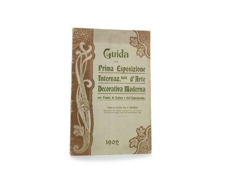
Lot 891
GUIDE FOR THE 1902 INTERNATIONAL EXHIBITION OF MODERN DECORATIVE ART, TURIN, thirty-two pace official guide with pull-out map, including 'Scozia' Note: The First International Exhibition of Modern Decorative Art was held in Turin from May to November 1902. The ‘Scottish Section’ was designed by Charles Rennie Mackintosh. In addition, one of the three rooms was dedicated to his and Margaret Macdonald’s work; in one half of the space they created the room setting for the famous ‘The Rose Boudoir’. The Guide fully covers the Exhibition and has a section titled ‘Scozia’ which mentions Rennie Mackintosh and his wife Margaret Macdonald, the head of Glasgow School of Art’s Francis H. (‘Fra’) Newbery, and the Glasgow School artists Herbert McNair, Frances Macdonald and Ann MacBeth, as well as others
-
109182 item(s)/page