We found 109182 price guide item(s) matching your search
There are 109182 lots that match your search criteria. Subscribe now to get instant access to the full price guide service.
Click here to subscribe- List
- Grid
-
109182 item(s)/page


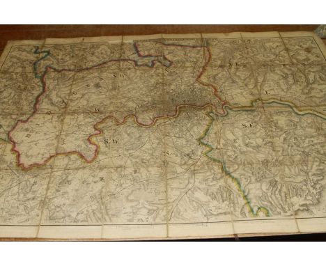
Lot 254A
comprising 34 images printed on calico, predominately of Egypt and the Middle East, together with a map, each image is numbered and stamped to the bottom corner 'Religious Tract Society, 56 Paternoster Row & 65 St Paul's Churchyard',each 120cm wide 91cm highCondition ReportCreases to most, if not all, and water damage to some

Lot 33
From The Estate Of Tom Owen (1949-2022) - The Onedin Line (BBC Drama Series 1971-1980) - Tom Owen's personally used scripts and filming schedule for the Series 3 episode 'Ice and Fire' in which he appeared as the character 'Tom'. Comprising of two scripts for the episode - one with many annotations by Owen, the other presumably a spare and unmarked, along with a 'Block Filiming Schedule' for Episodes 6-9 with a locations map to the rear. A4. All in production used condition. The Onedin Line was a BBC television drama series that ran from 1971 to 1980. The series was created by Cyril Abraham. It was set in Liverpool from 1860 to 1886 and covers the rise of a fictional shipping company, the Onedin Line, named after its owner captain James Onedin. Around this, it depicts the lives of his family, most notably his brother and partner Robert, a ship chandler, and his sister Elizabeth, giving insight into the lifestyle and customs at the time, not only at sea, but also ashore (mostly lower- and upper-middle-class). The series also illustrates some of the changes in business and shipping, such as from wooden to steel ships and from sailing ships to steamships. It shows the role that ships played in such matters as international politics, uprisings and the slave trade.


Lot 1453A
OF EXETER INTEREST; a 1906 Exeter Carnival official programme, A World War One pamphlet from the war hospital Exeter "IT", an auction catalogue for the sale of "Winslade Estate" in 1905 including map, catalogue for a building plot at No 9, Baring Crescent, Exeter, together with three pre-war photographs of Sidwell Street, High Street and The Royal Clarence, each 23.5cms x 30cms

Lot 1481
Boy Scouts Association, a collection of cloth badges, metal badges, includes 8th World Jamboree, Canada 1955, together with a large blanket covered with numerous cloth badges, embroidered with a map of Great Britain with Cub pack badges and overseas badges and pennants (all badges hand sewn onto the blanket).


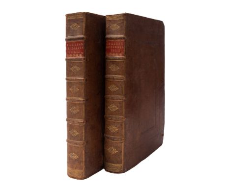
Lot 100
CAMDEN, William, Britannia: Chorographical Description of Great Britain and Ireland, together with the Adjacent Islands... published with large editions by Edmund Gibson, 2 vols, portrait engraved frontispiece, title in red and black, double page map of England and Wales, double page map of Britannia, nine full page illustrations of coins, double page of map of Britannia Saxonica, double page County Maps, contemporary calf, minor wear, some maps detached, 1722 (2)


Lot 131
KITCHEN, Thomas - Bowles's Reduced Map of Devonshire, uncoloured map, size 280 x 310mm, age discoloured, 2 short tears without loss, 1782, With - Morden, Robert. Devonshire, uncoloured map, size 410 x 360 mm, c1695, With - Cooke's New Plan of the Three Towns of Plymouth, Devonport, and Stonehouse, uncoloured plan, size 520 x 255 mm, early 19th century, with one other. (4)


Lot 92
HARWOOD, Thomas - The History and Antiquities of the Church and City of Lichfield : Plates. Original boards worn lacking most of the spine, title-page loose otherwise text is good. 4to. Printed by Jos. Harris, Gloucester. 1806. With - Newcome, Peter. The History of the Ancient and Royal Foundation, called The Abbey of St. Alban, .. (etc) . Contemporary boards lacking spine. 4to. 1790. With - Charlton, Lionel. The History of Whitby, and of Whitby Abbey ....(etc) very large folding map torn on folds but complete. Blue paper covered boards leather spine, worn. Text fresh. 4to, York. 1779. With - Dalrymple, Sir John. Memoirs of Great Britain and Ireland. From the dissolution of the last Parliament of Charles 11. Until the sea-battle off La Hague. Old boards worn loose paper spine. uncut pages. 4to. second edit. 1771. (4)


Lot 163
Intercity Routes of Britain Map in black routes showing the Swallow Emblem on melamine board measuring 23.5in x 16.5in and with an added sticker regarding comments and a York contact address. Produced by Intercity for British Railways Board in 1989. Although only 30 odd years old, it has become a desirable piece of history. Excellent condition.


Lot 500
A miscellany comprising: x20 locomotive and other railway Postcards; LMS Booklet Triumph Of The Royal Scot and another Electric Loco; a quantity of Photographs including 10100; Lubrication chart for 7090 to 7099 Diesel Shunter and a Bartholomew's Railway Map mounted on cloth in very good condition.
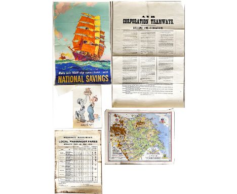
Lot 517
Miscellany of Posters comprising: Mersey Railways Local Passenger Fares dated July 1936, R. Varley General Manager, 20in x 15in with multiple defects; Ayr Corporation Tramways Byelaws & Regulations 22nd November 1901, 30in x 20in with folds; Make Sure Your Ship Comes Home With National Savings, 29in x 19.5in which has 2 smaller National Savings Posters with an accompanying letter from the Scottish Savings Committee regarding supply of such posters dated October 1946; A Map of Yorkshire published by Leak & Thorp York from a map drawn for British Railways in 1949, 22in x 17.5in, folds and edge crinkling. (6 items)

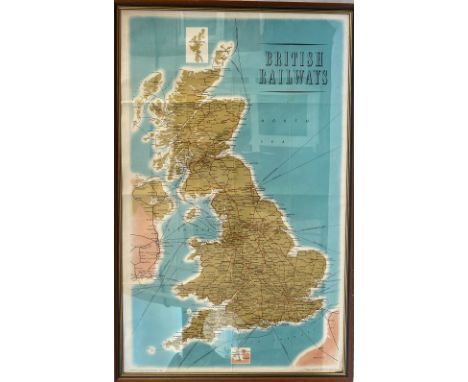
Lot 519
A pair of British Railways Double Royal size Map Posters comprising International Connections, published by the Railway Executive Southern Region and printed by Ernest Day; British Railways London Midland Region with insets for Nottingham, Birmingham, Liverpool & Manchester and London, tears and other defects. (2 items)

Lot 520
London & North Eastern Railway Poster, A Map of Northumberland & Durham, Double Royal size published by the Railway Executive North Eastern Region and printed by Waterlow. Together with a British Railways and Macbrayne's Services Poster SCOTLAND WESTERN HIGHLANDS AND ISLANDS, Double Royal size published by David Macbrayne and printed by John Horn, Glasgow. Both have folds and other defects. (2 items)
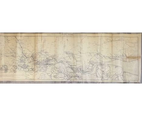
Lot 76
Midland Railway Diagram of Distances in the London Area and on the London Tilbury & Southend Section. Measuring 60in x 20in, this map dated 1916 is a significant depiction of the entire system having enlargement panels of Acton, Upminster, Romford, East Ham & Barking and Tilbury. Tape repairs on both edges, the item has been laminated for protection.


Lot 539
Group of five maps to include 'Carte des Isles de la Societe' from Cook 1er Voyage, 25 x 36cm; Les Isles Vierges / Supplement Pour Les Isle Antilles hand coloured engraving, 33 x 22.5cm; map featuring Donnington Caftle, East Ilfley, Hamps & Barks, hand coloured engraving, 19 x 12cm; map of Oxfordshire bordered by college crests; and a 'Carte Des Isles Bermudes' map. All framed & glazed
![Vintage culinary colour map of Italy showing regional dishes.[Frame 78x58cm]](https://cdn.globalauctionplatform.com/c4751238-5d2c-4ca4-b8c3-b0e000b2965f/d3bce876-cc14-43e8-bcd4-b0e000c6819a/468x382.jpg)


-
109182 item(s)/page