

Jansson, Jan 1653 Hibernia Regnum Vulgo Ireland One of the most beautiful maps of Ireland, this was based on Speed`s map and is geographically nearly identical. The map has finely engraved detail of the provinces of Leinster, Ulster, Connaght and Munster filled with counties, towns and charming pictorial topography. The upper and lower portions of Lough Erne in Ulster are oddly shaped, with a note between them relating, "At this place ly the landes, of O Darra, O Harna, O Harra Boy, O Harra Neirogh, the 2 McDonnoghes with other Erecholders." The map is adorned with the crest of Britain, and below that, the cartouche is topped with the crest of Ireland; the scale of miles is supported by two aquatic putti. Spanish text on verso, published between 1653-66. 19.8" W x 15.2" H A nice impression with wide margins and professional repairs to separations along the centerfold.
We found 109182 price guide item(s) matching your search
There are 109182 lots that match your search criteria. Subscribe now to get instant access to the full price guide service.
Click here to subscribe- List
- Grid
-
109182 item(s)/page

Keulen, Johannes van 1681 Nieuwe Pas-Kaert vande Oost Kust van Yrland, Beginnende van de Hoeck van Waterfoort tot aen de Mayds, als mede de West Kust van Engeland van S. David tot Moul van Galoway… Large sea chart covering St. George`s Channel with the coasts of Ireland and England. Nice detail of the coastlines and islands including anchorages and soundings. Rhumb lines, sailing ships, and compass roses adorn the map and the title cartouche features a boy and two dogs. 22.6" W x 19.4" H A slightly uneven impression, especially around the cartouche, on watermarked paper with excess printer`s ink along the centerfold.

Wit, Frederick de 1680 Novissima nec non Perfectissima Scandinaviae Tabula Comprehendens Regnorum Sueciae, Daniae et Norvegiae Distincte Divisam Descriptionem This finely detailed map of Scandinavia and the Baltic provides a great deal of information, particularly in Sweden and along the coastlines. The title cartouche features putti and the coats of arms of Norway, Sweden and Denmark. 23.2" W x 19.9" H Bold original color that has been partially refreshed, with light soiling and a few tiny cracks caused by the oxidation of the green pigment that have been archivally reinforced. Several small chips in blank margins have been professionally repaired, including two that enter the map border in top corners, with the border expertly replaced in facsimile.

Kircher, Athanasius 1682 Descriptio Vorticis Norvegiae et Bothniae Eorumqe Mirabilium Effectuum, quos in Fluxu et Refluxu Operantur This interesting small map shows Scandinavia with two "vortices"; one off the western coast of Norway and the other in the Gulf of Bothnia linked by an underground canal. The one off the coast of Norway is known as the original maelstrom, a name used to describe a destructive whirlpool. Kircher`s work was the first serious effort to describe the physical makeup of the earth, proposing theories (sometimes fantastic) in the areas of physics, geography, geology, and chemistry. Among his theories was the existence of a vast network of underground springs and reservoirs interlinked with a system of ocean circulation. Published in a Dutch edition of Kircher`s famous "Subterranean World" by Johann Waesberger. On a full sheet of Dutch text measuring 9.8 x 14.9". 7.7" W x 7.8" H Marginal soiling.

Moll, Herman 1720 Sweden and Norway Agreeable to Modern History A copper engraved map of Sweden and Norway showing towns, topographical features, and even a few roads. An inset at the top left details the North Cape of Norway. Notations describing the size of the region and the city of Stockholm appear on either side of the map. 10.3" W x 7.6" H On watermarked paper with one small brown spot in the image.
![1765-78 [Lot of 2] A New and Accurate Map of Sweden and Norway from the Sieur Roberts Atlas with Improvements [and] La Suede](http://lot-images.atgmedia.com/SR/36385/2893812/427-2013117142142_468x382.jpg)
1765-78 [Lot of 2] A New and Accurate Map of Sweden and Norway from the Sieur Roberts Atlas with Improvements [and] La Suede "A nice duo of eighteenth century maps of Scandinavia, both filled with details of towns, political boundaries, rivers, and topography. A. “A New and Accurate Map of Sweden and Norway from the Sieur Roberts Atlas with Improvements”, by John Gibson, from “Geographical Dictionary”, circa 1765 (11.3 x 7.7”). Gibson`s map includes an inset of Iceland, a compass rose capped with a fleur-de-lis, and an ornate title cartouche. Condition: A few tiny spots. (A) B. “La Suede”, by Didier Robert de Vaugondy, circa 1778 (7.5 x 9.4”). This is the second state. Reference: Pedley #66. Condition: This example has wide margins as well as some printer`s ink residue and a few errant spots of color. (B+)" #VALUE! See description.

Blaeu, (Family) 1640 Ducatus Uplandia A decorative map of the area around Stockholm with well-engraved detail of the interconnected waterways from the Baltic through to Lake Malaren and its tributaries. The map is embellished with a number of coats of arms with the heraldry for Uppsala being the most prominent. The map is dedicated to Michael Le Blon in the lower left, while farmers and allegorical figures flank the title cartouche on the right. This is the first state with Latin text on verso, published between 1640-43. 19.8" W x 15.2" H A fine impression on watermarked paper with original margins and minor offsetting.

Wit, Frederick de 1680 Norvegia Regnum Divisum in suos Dioeceses Nidrosiensem, Bergensem, Opsloensem, et Stavangriensem et Praefecturam Bahusiae... Handsome map of Norway fully engraved with political boundaries, towns, and the topography of the land. An inset at top left depicts the northern coastline. The map is adorned with a decorative title cartouche surrounded by putti and the coat of arms of the region. 20" W x 23.5" H A nice impression with a few tiny worm tracks near the centerfold at far right and a centerfold separation at left that extends 0.5" into the image and has been closed on verso with archival tape.

Moll, Herman 1710 A Chart of the Baltick or East Sea. Gulf of Finland &c. A scarce chart of the Baltic Sea focusing only on the coastlines. The elegant map centers on a decorative compass rose with radiating rhumb lines. 13.8" W x 11.3" H On watermarked paper with minor toning along the centerfold, a printer`s smudge, and a few edge tears confined to the blank margins.

Sanson, Nicolas 1658 Royaume de Danemarq The handsome map, engraved in Sanson`s distinctive style, is centered on Sjaelland and covers all of Denmark and part of southern Sweden where a dramatic title cartouche obscures the interior. Engraved by R. Cordier. 20.5" W x 15.9" H A nice, early impression on watermarked paper with original outline color and later color in the cartouche. There are a couple of insignificant spots and light toning along sheet edges.

Homann, Johann Baptist 1738 Regni Daniae, in quo sunt Ducatus Holsatia et Slesvicum, Insulae Danicae, Provinciae Iutia Scania Blekingia &c. Nova Tabula This magnificent map covers all of Denmark, the northern tip of Germany and the southern tip of Sweden. The land is fully engraved with mountains, forests and cities. The title cartouche is quite elaborate with a host of livestock and the traditional woodwose standing guard over the coat of arms in the center. 22.5" W x 19.3" H Original color on heavy paper with light soiling and some color offsetting.

Wit, Frederick de 1680 Iutiae Tabula in quae sunt Dioeceses Alburgensis, Wiburgensis, Ripensis et Arhusiensis quae et sunt Divisiae in Omnia Dominia This beautifully engraved map covers the northern and western portions Denmark. The map is filled with minute detail of fortresses, cities, towns and tiny villages. Adorned by a very decorative title cartouche flanked by local herders and a distance scale cartouche held up by a putto. 18.9" W x 23.1" H A fine impression with light toning along the centerfold and a few small wormholes near the centerfold at far right.

Sanson/Jaillot, 1692 Gueldre Espagnole, ou Quartier de Ruremonde dans le Duche de Gueldre Attractive engraving covering the area of the Spanish possessions in Gelderland with the towns of Roermond and Venlo at center. The map is filled with tiny villages, towns, lakes and rivers. Adorned by a decorative strapwork title cartouche and five distance scales. 21.7" W x 16.7" H Original color with moderate toning, several brown stains, and a few small centerfold separations that have been closed on verso with archival tape.
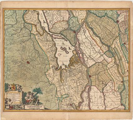
Visscher, Nicolas 1680 Hollandiae Pars Meridionalior, Vulgo Zuyd-Holland This attractive map is centered on De Biesbosch, now known as one of the last freshwater tide areas in Europe. The map extends to include Breda, Dordrecht, and Gouda. The tiny street patterns of the major cities are shown along with good detail of the surrounding provinces. A compass rose, several sailing ships, and a title cartouche featuring putti and a river god decorate the map. 22.4" W x 18.4" H Lovely original color that has been partially refreshed with light soiling, a professionally repaired centerfold separation at bottom, and several small chips and tears in blank margins that have also been professionally repaired..

Visscher, Nicolas 1680 Delflandia, Schielandia et Circumjacentes Insulae ut Voorna, Overflackea, Goerea, Yselmonda et Aliae, ex Conatibus Geographicis This detailed road map shows the estuary of the River Maas and extends from `s-Gravenhage to Gouda in the north and from Ouddorp to Steenbergen in the south. Cities, such as Rotterdam, Delft, and Brielle are depicted with miniature bird`s-eye plans. A compass rose orients north to the top right, and the map is further adorned with sailing ships, some engaged in battle, and a drape-style title cartouche held aloft by putti. 22.3" W x 18.3" H Lovely original color that has been partially refreshed, light soiling, professionally repaired centerfold separations at top and bottom, and faint damp stains that just enter map borders at right and left.

Munster, Sebastian 1552 Tabula Europae III This is a woodcut map of France and the Low Countries west of the Rhine river. The map is typically Ptolemaic - set within a trapezoidal frame with rope-like mountain ranges and broad rivers. The place names "Parisij "and "Alpes" are recognizable, but many of the other Roman place names are not. Latin text on verso marked page 5. 13.3" W x 10.8" H There is a stain on verso that is just barely visible in the bottom right corner of the map image, else fine.


Tardieu, Ambroise 1832 Carte Geologique du Departement de la Seine-Inferieure et des Parties Limitrophes des Departements Voisins This geological map depicts a portion of Haute-Normandie, with Rouen located roughly at center. The map shows the mouth of the Seine River and extends east to Beauvais (in the region of Picardie) and as far north as Dieppe and Eu. A color-coded legend identifies 10 different geological units, including gypsum and chalk. Scores of towns, roads and rivers are also shown. Published by Ant. Passy. Dissected and mounted on linen with a hand-written paper label on verso. 31.1" W x 22.1" H Original color with light soiling. A few of the dissected panels are separating from the linen in some spots.

1813 Nouveau Plan Routier de la Ville et Faubourgs de Paris Divise en Douze Mairies This detailed bird`s-eye plan of Paris is divided into 12 arrondissements ("mairies"). Numerous tables flank the map with lists of arrondissements, parishes, streets, streets that have changed name, markets, docks, and prisons. Published by Journeaux l`Aine. Folds into orange paper boards with a paper label on front cover. 30.3" W x 21.7" H Original color on heavy, bluish watermarked paper with light toning along folds, a few short fold separations, and a couple of stains. Covers are stained and worn.

Hachette, Louis Christophe Francois 1856 Nouveau Plan de Paris This detailed folding plan of Paris shows all the streets and boulevards as well as monuments and places of interest, including the Louvre and Notre Dame. The map folds into black embossed cloth covers and contains a 31 pp. street directory. Drawn by Vuillemin and engraved by E. George. 30.8" W x 25.9" H Issued folding and backed with linen. There are numerous light stains in the image and the front cover and attached street directory are detached.

Ortelius, Abraham 1601 Regni Hispaniae Post Omnium Editiones Locuplettissima Descriptio This is a very attractive map of the Iberian peninsula surrounded by stipple engraved seas, in which there are ships and sea monsters. The land is full of cities, mountains and forests. A large strapwork title cartouche and scale of miles with a divider ornament the map. Latin text on verso, published between 1601-12. 19.5" W x 14.8" H Attractive color on watermarked paper with a couple of professionally repaired centerfold separations.

Zatta, Antonio 1775 La Catalogna li Regni di Aragona, ed Alta Navarra di Novissima Projezione This striking map focuses on three of Spain`s autonomous communities: Catalonia, Aragon, and Navarre. The mountainous topography of these areas is depicted along with many towns and rivers. The map extends beyond northwestern Spain to show the Spanish-French border, a bit of Basque Country, and Valencia. The wonderful title cartouche provides a glimpse into the rural activity in the region. 15.2" W x 11.2" H On watermarked paper with original color and ample margins, light toning along the centerfold, and a couple of notations in pen strictly confined to the blank margins.

Kircher, Athanasius 1682 Typus Hydrophylacii Intra Alpes Rhaeticas, quod Sundit Totius Europae Celeberrima Flumina; Uti Patet This is an interesting map of the Alps, the great mountain range of south-central Europe. It depicts a huge mountain in Switzerland with a huge underground lake that is the source of all the major river systems in the region. This is from Kircher`s masterpiece, an immense and amazing work covering all aspects of anything that dwelled or occurred within the earth`s interior - from dragons, to fossils, to mountain springs, earthquakes, and volcanoes. Kircher`s work was the first serious effort to describe the physical makeup of the earth, proposing theories (sometimes fantastic) in the areas of physics, geography, geology, and chemistry. He suggested the existence of a vast network of underground springs and reservoirs, as well as the theory that subterranean temperatures increase directly in proportion to depth. Published in a Dutch edition of Kircher`s famous "Subterranean World" by Johann Waesberger. On a full sheet of Dutch text measuring 9.8 x 14.9". 7.6" W x 6.1" H Marginal soiling.

Homann, Johann Baptist 1720 Ducatus Meklenburgici Tabula Generalis Continens Duc. Vandaliae et Meklenburg Comitatum et Episcopatum Swerinensem Rostochiense et Stargardiense Dominium Bold, decorative map covers the region from Holstein and Lubeck in the west to Rugia and Pomerania in the east. The principal cities include Lubeck, Schwerin, Rostock, Gustrow, Stralsund, and Waren. Several chubby putti surround the large title cartouche with the coat of arms. 22.8" W x 19.3" H Bright color and a crisp impression on a clean sheet with a centerfold separation just entering the neatline at bottom that has been closed with archival tape on verso.

Seutter, Albercht Karl 1756 Intervalla Viaeque Publicae Electoratus Saxoniae… This is a rare and extremely interesting postal map of Saxony. The map is centered on the course of the Elbe, from Magdeburg to Prague and extends from Gotha to the Silesiae (Polish) boundary. It emphasizes the postal roads with the distances between the larger towns and villages noted. The large map is embellished with a title cartouche and a quaint allegorical scene showing the messenger, "Mercury", in a chariot drawn by four "Pegasus" steeds, and another of the hunting goddess, "Diana", in her chariot drawn by a pair of stags. Printed on two joined sheets, as issued. 37.8" W x 22.3" H Issued folding, with two tiny splits at fold intersections, minor toning and soiling, and some light damp stains in the margins.

Jansson, Jan 1680 Comitatus Glatz Handsome map of the Silesia region with Glatz at center. The forested region was renowned for its wild game and the map includes tiny illustrations of the wildlife. Two dogs paw at an armillary sphere atop the decorative title cartouche, and another cartouche encloses the distance scale and key. A coat of arms adorns the upper left corner. 17.9" W x 14.9" H There is light toning along the centerfold, a 1/2" centerfold separation that has been closed with hinge tape on verso, and a long extraneous crease to the left of the centerfold.

Mercator/Hondius, 1606 Bohemia This fine map of Bohemia is centered on Prague. It is boldly engraved in Mercator`s style with mountains, forests and hundreds of tiny villages. Two strapwork cartouches at bottom hold the title and distance scale. Latin text on verso. 19" W x 13.5" H Old color on watermarked paper with wide margins, light printer`s ink residue, and some stains confined to the edges of sheet due to the use of non-archival tape on verso, and a chip in top left corner. There is a small crack at left caused by the oxidation of the green pigment that has been closed on verso with archival tape.
![Rollos, George 1759 [Lot of 2] An Accurate Map of the Marquisate of Moravia, from the Sieur Robert: with Improvements [and] A](http://lot-images.atgmedia.com/SR/36385/2893812/470-201311714236_468x382.jpg)
Rollos, George 1759 [Lot of 2] An Accurate Map of the Marquisate of Moravia, from the Sieur Robert: with Improvements [and] An Accurate Map of the Kingdom of Bohemia Drawn from the Best Authorities "A. “An Accurate Map of the Marquisate of Moravia...”. Shows the region of Moravia bordering Austria and Hungary and adorned by a decorative title cartouche. B. “An Accurate Map of the Kingdom of Bohemia”. At attractive map centered on Prague with roads, rivers and place names depicted. A decorative title cartouche is located at bottom right." 11.3" W x 7.6" H Nice impressions with a couple of tiny, insignificant spots.

1855 Roadmap of Switzerland / Reisfahrig der Schweiz / Carta Stradale della Svizzera / Carte Routiere de la Suisse This densely engraved map of Switzerland is translated into four languages: English, German, Italian and French. The topography of the land is well-depicted, and a detailed legend at bottom identifies everything from towns of various sizes, railroads, post roads, horse trails, canals, tunnels, and forts to pilgrimages, ruins, cheese factories, caverns, battle fields, and more. In the four corners are inset maps of the neighboring regions. On verso are miniature bird`s-eye plans of Geneva, Basel, Bern and Zurich as well as a table of distances between towns and other statistical information. Engraved by H. H. Mullhaupt and published by H. F. Leuthold. Dissected and mounted on linen and housed in a paper board slipcase. 36" W x 25.5" H Very light soiling and wear. Slipcase is lightly soiled and worn.
![1759-60 [Lot of 2] A New Map of the Circle of Austria; from the Best Authorities [and] A View of the City of Vienna "A.](http://lot-images.atgmedia.com/SR/36385/2893812/473-2013117142312_468x382.jpg)
1759-60 [Lot of 2] A New Map of the Circle of Austria; from the Best Authorities [and] A View of the City of Vienna "A. “A New Map of the Circle of Austria; from the Best Authorities”, by George Rollos, from Barrow`s “New Geographical Dictionary”, circa 1759 (11.3 x 7.6”). Shows towns and cities, topography and watershed with the Danube boldly depicted. Adorned by a decorative title cartouche. Condition: (A) B. “A View of the City of Vienna”, from “Royal Magazine”, circa 1760 (8.6 x 6.5”). Attractive view of the city with the Danube River shown passing through it. Condition: Issued folding with light foxing. (B)" #VALUE! See description.


Ottens, Reiner and Joshua 1730 Partie Meridionale de Moscovie Dressee par G. de l`Isle Boldly engraved map depicts the southern part of the Russian Empire including Moscow and part of present-day Ukraine. The map is based on Delisle`s important map of the region with revisions by Ottens. 21.7" W x 16.4" H A fine impression with original color, wide margins, and one tiny hole in image.

Blaeu, (Family) 1640 Russiae, Vulgo Moscovia, Pars Australis. Auctore Isaaco Massa This map covers the southwestern part of the Russian Empire bordering the Caucasus. The cities of Moscow, Smolensk, Vologda, Nizhniy Novgorod, and Azov are depicted with miniature castles, and smaller towns are shown along the river systems in the region. The map is elaborately embellished with richly dressed people and wild animals flanking three cartouches. The strapwork title cartouche credits the map to Isaac Massa, who visited Moscow in the early 1600s. The imprint of Johann and Cornelius Blaeu is at bottom, just left of centerfold. Latin text on verso, published between 1640-43. 20.8" W x 15.3" H A fine impression on watermarked paper with a professionally repaired centerfold separation at top.
![Bellin, Jacques Nicolas 1758 [Lot of 3] Carte des Pais Habites par les Samojedes et Ostiacs [and] Partie de la Mer Glaciale,](http://lot-images.atgmedia.com/SR/36385/2893812/482-2013117142330_468x382.jpg)
Bellin, Jacques Nicolas 1758 [Lot of 3] Carte des Pais Habites par les Samojedes et Ostiacs [and] Partie de la Mer Glaciale, Contenant la Nouvelle Zemble et le Pais des Samoiedes [and] Carte du Detroit de Waeigats, ou de Nassau "Attractive lot of three maps focusing on the island of Novaya Zemlya, here named “Nouvelle Zemle”, off Russia`s northwestern Arctic coast. The Russian mainland is shown with mountains, rivers, and inlets, and the location of the Samoyedic people is noted. The first two maps show the entire island along with the northern coast of Russia, while the third map details the southern part of Novaya Zemlya and the Kara Strait. A. “Carte des Pais Habites par les Samojedes et Ostiacs” (9.6 x 6.3”). Condition: Watermarked paper with some light toning along centerfold. B. “Partie de la Mer Glaciale, Contenant la Nouvelle Zemble et le Pais des Samoiedes” (13.7 x 8.5”). Condition: Watermarked paper with a few small spots. Remargined at left and right. C. “Carte du Detroit de Waeigats, ou de Nassau” (12.0 x 7.8”). Condition: Watermarked paper with some light toning along sheet edges." 9.6" W x 6.3" H See description.

Mercator, Gerard 1609 Taurica Chersonesus nostra Aetate Przecopsca, et Gazara Dicitur Mercator`s fine map of the region north of the Black sea encompasses the Crimea and the southern steppes of Ukraine. This map served as the basis of most other cartographer`s depictions of the region throughout the seventeenth century. The interior is filled with large forests and mountains with little information on settlements except along the rivers. It is embellished with small strapwork title cartouches. French text on verso. 15.8" W x 12.3" H Original color and wide margins on watermarked paper with light toning and minor creasing along the centerfold. There is discoloration in the blank margins due to the use of non-archival tape on verso, far from map image.

Blaeu, (Family) 1640 Taurica Chersonesus, Nostra Aetate Przecopsca, et Gazara Dicitur Attractive map of the region north of the Black Sea based on Mercator with the toponym from medieval portolan charts. The map covers the region from Moscow in the north to the Black Sea and from the mouth of the Danube to approximately Sochi in the east. The interior is filled with large forests and mountains with little information on settlements except along the rivers. It is embellished with small strapwork title and scale of miles cartouches and three ships. Latin text on verso, published between 1640-43. 19.8" W x 15.1" H Watermarked paper with light show-through of text on verso, minor soiling, and professional repairs to a few short centerfold separations and a clean cut that enters 3" into map at top adjacent to centerfold.

Cantelli da Vignola/de Rossi, 1684 Tartaria d Europa Overo Piccola Tartaria... This rare map of the Ukraine extends south to Istanbul, north to Moscow, and east to the Caspian Sea. The map is filled with information on towns, political boundaries, rivers, mountains, and forested areas. The large allegorical title cartouche represents the numerous conflicts waged in the region, with warriors on horseback carrying swords, spears, and bows and arrows. The map was created by Giacomo Cantelli da Vignola, a cartographer from Modena, Italy who worked on many maps in Giovanni Giacomo de Rossi`s atlas, "Mercurio Geografico". Engraved by Vincenzo Mariotti. 21.7" W x 17" H A dark impression on watermarked paper with original outline color in map and later color in cartouche. There is a stain along centerfold at top caused by the use of non-archival tape on verso, and there is one small crack caused by the oxidation of the original green pigment that has been professionally reinforced on verso. There are light soiling, a faint damp stain that enters 2.5" into map at bottom, and very narrow top and bottom margins.

Ortelius/Marchetti, 1598 Transilvania Attractive miniature map of Romania and Hungary and the surrounding region. The tiny map is filled with place names, each symbolized by a tiny castle and pictorial depictions of the mountainous countryside. Pietro Maria Marchetti produced the second pocket atlas based on Abraham Ortelius` folio "Theatrum". It is often referred to as the plagiarized version of the "Epitome". The copper plates are closely copied from those of Philip Galle`s 1593 Italian edition. On a full sheet of Italian text measuring 5.5 x 7.6". 4.1" W x 2.9" H Watermarked paper with marginal soiling and a light damp stain along bottom edge of sheet.

Ptolemy/Mercator, 1730 Tab. V. Europae, in qua Raetia, Pannonia, Noricum, Liburnia, Dalmatia, cum Italiae Parte... An attractive Ptolemaic map of the Balkan coast and northern Italy along the Adriatic Sea, extending north to include parts of Austria and Hungary. The map is embellished with a strapwork cartouche and a sea monster. Mercator originally published this map in his 1578 edition of Ptolemy`s great Geography. Although he is most renowned today for the projection he popularized and for first using the term "Atlas" for a collection of maps, he devoted much of his life to his Ptolemaic maps. The maps were beautifully engraved as nearly as possible to their original form and embellished with fine cartouches. This is the third state with a re-engraved title cartouche and the addition of a grid, published by R. and J. Westenios and Guil. Smith. There is evidence of a crack in the plate at bottom adjacent to the sea monster. 17.9" W x 12.5" H Nice impression and color on watermarked paper with a printer`s crease adjacent to centerfold and light toning along sheet edges, far from image.
![Munster, Sebastian 1565 [Les Citez & Villes de la Transsylvanie] Bold wood block map of the Balkans covering the regions](http://lot-images.atgmedia.com/SR/36385/2893812/489-2013117142342_468x382.jpg)
Munster, Sebastian 1565 [Les Citez & Villes de la Transsylvanie] Bold wood block map of the Balkans covering the regions of present-day northern Greece, Macedonia, Kosovo, Bulgaria, Serbia and Romania. Only the major cities are shown with castle icons. On a full sheet of French text measuring 8.4 x 12.1". 7.4" W x 6" H A nice impression with attractive color, a few tiny worm holes only visible when held to light, and a professionally repaired cut running along the neatline at left.

Ortelius/Marchetti, 1598 Slavoniae, Croatiae, Carniae, Istriae, Bosniae, Descri. Lovely miniature map of northeastern section of the Balkans - present day Slovenia and Croatia with the Adriatic Sea located at the lower left. The map is filled with tiny cities and good detail of the rivers systems. Pietro Maria Marchetti produced the second pocket atlas based on Abraham Ortelius` folio "Theatrum". It is often referred to as the plagiarized version of the "Epitome". The copper plates are closely copied from those of Philip Galle`s 1593 Italian edition. On a full sheet of Italian text measuring 5.6 x 7.6". 4" W x 2.8" H Watermarked paper with marginal soiling and light show-through of text on verso.

Blaeu, Willem 1640 Walachia Servia, Bulgaria, Romania This attractive map of the Eastern Balkans is centered on Bulgaria and includes Macedonia, Serbia, the Bosphorus and Constantinople. It is based on Gerard Mercator`s map of the region. The Danube and its tributaries flow across the map. It is adorned with decorative title and distance scale cartouches, the title festooned with the accoutrements of war and topped with emblem of the Turkish Empire. Latin text on verso, published between 1640-43. 20.1" W x 15.2" H A nice impression with attractive color, some printer`s ink residue, light offsetting, and a professionally repaired centerfold separation at top.
![Porcacchi, Tomaso 1576 [Lot of 17 - Greece] "This lot includes 17 maps of Greece and its islands published in Porcacchi`](http://lot-images.atgmedia.com/SR/36385/2893812/495-2013117142354_468x382.jpg)
Porcacchi, Tomaso 1576 [Lot of 17 - Greece] "This lot includes 17 maps of Greece and its islands published in Porcacchi`s “L`Isole piu Famose del Mondo”, all engraved by Girolamo Porro of Padua. Each map is on a full sheet of Italian text (7.0 x 10.5”). Size varies slightly. This lot includes: A. “Arcipelago”. Condition: A spot of printer`s ink residue and marginal soiling. (B+) B. “Il Sito de` Curzolari”. Condition: There are a number of cracks that have been closed on verso with archival tape and marginal soiling. (B) C. “Morea Penisola”. Condition: Light soiling and a few small worm holes in text below map. (B+) D. “Negroponte”Condition: Numerous minute pinholes along coastlines, light soiling, and manuscript writing in blank margins. (B) E. “Corfu”Condition: Light soiling with one small ink spot in image. (B+) F. “Milo”Condition: Light soiling with a few small worm holes in image at left. (B) G. “Zante”Condition: Light soiling with a printer`s crease above compass rose. (B+) H. “Scarpanto”Condition: Some soiling with a worm track in text below map. (B+) I. “Rhodi”Condition: Minor soiling. (B+) J. “Candia”Condition: There is light soiling, show-through of manuscript ink on verso, and a worm track in text below map. There is an old paper repair in right blank margin. (B) K. “Santorini”Condition: A couple of faint spots and a tiny worm hole in left blank margin. (B+) L. “Stalimene”Condition: Light soiling. (B+) M. “Metellino”Condition: Marginal soiling. (A) N. “Scio”Condition: Light soiling. (B+) O. “Nicsia”Condition: There are a few small worm holes in map at left, and an old paper repair in left blank margin. (B+) P. “Cefalonia”Condition: Light soiling with a small worm hole and ink stains in text below map. (B+) Q. “Cerigo”Condition: Light soiling with a worm track in text below map. (B+)" 5.5" W x 4" H See description.

Delisle, Guillaume 1707 Carte de la Grece Dressee sur un Grand Nombre de Memoires Anciens et Nouveaux... This large, detailed map shows Greece and the western part of Turkey. It extends to show the boot of Italy, Albania, Macedonia, and part of Cyprus. Decorated with a lovely allegorical title cartouche that includes ruins, a figure in a yoke, and a winged old man. 25.7" W x 17.9" H On watermarked paper with light scattered stains and minor toning.

Cluver, Philipp 1697 Macedoniae et Thessaliae Regiones This handsome map shows the historical regions of Macedonia and Thesalia in northern Greece. It is embellished with a strapwork title cartouche themed on the ancient military heroes of the region. 10.1" W x 7.9" H A dark impression with attractive color.

Cluver, Philipp 1697 Peloponnesus nunc Morea Charming map of the Peloponnesian peninsula, the heart of ancient Greece, with the cities of Sparta, Corinth, Argos and Olympia. An inset plan of Corinth balances the title cartouche featuring Neptune and his entourage. 10.1" W x 8.3" H Attractive color with a hint of toning along centerfold and a couple of tiny spots.

Ortelius/Marchetti, 1598 Corcyra vel Corfu Miniature map of this important Greek island, handsomely adorned with a sailing ship and a sea monster. Pietro Maria Marchetti produced the second pocket atlas based on Abraham Ortelius` folio "Theatrum". It is often referred to as the plagiarized version of the "Epitome". The copper plates are closely copied from those of Philip Galle`s 1593 Italian edition. On a full sheet of Italian text measuring 5.5 x 7.5". 4.1" W x 2.9" H Watermarked paper with marginal soiling and minor show-through of text on verso.

Seutter, Matthias 1725 Nova et Exactissima Totius Italiae Sardiniae et Corsicae Delineatio Opera et Impensis Superb 18th century map of the whole of Italy, which also includes the islands of Corsica and Sardinia, part of Sicily, and the coastline of the Balkans. Beautifully engraved with Seutter`s typical bold style and detail. Title cartouche at top right features several cherubs and in the opposite corner the distance scale supports a river god, a globe and several putti. 22.5" W x 19.4" H Attractive color with scattered foxing, a long centerfold separation that has been closed on verso, and a tiny tear near center of map that has been closed with archival tape.

Elwe, Jan Barend 1792 L`Italie Dressee sur les Observations de Mrs. de l`Academie Royale des Sciences... A fine large map showing all of Italy, including Sicily, Sardinia and Corsica, the surrounding parts of France and the Balkans, and a portion of North Africa. It is based on the geography of Guillaume Delisle and the observations of the astronomer Riccioli. The map is filled with detail and decorated with an ornate title cartouche alluding to the Catholic Church, with a cherub wearing a cardinal`s miter. 21.6" W x 18.2" H Original color on bluish, watermarked paper with wide margins and a hint of toning along the centerfold.
![Walker, Samuel 1840-52 [Lot of 2] Italy [and] Plan of the City of Syracuse Beseiged by the Athenians "A. “Italy](http://lot-images.atgmedia.com/SR/36385/2893812/504-2013117142414_468x382.jpg)
Walker, Samuel 1840-52 [Lot of 2] Italy [and] Plan of the City of Syracuse Beseiged by the Athenians "A. “Italy”, circa 1840 (7.6 x 9.1”). Detailed map of the nation naming regions and showing cities, rivers, and mountains. Engraved by Boynton. Condition: Lightly foxed with a short edge tear well away from image. (B+) B. “Plan of the City of Syracuse Beseiged by the Athenians”, from “Rollin`s History”, circa 1852 (6.4 x 8.1”). Striking plan of the historic city of Syracuse in Sicily featuring topographical detail, fortifications, and other structures. A key at bottom identifies the various Athenian and Syracusan fortifications. Engraved by Kelly. Condition: Faint foxing in the blank margins. (A)" #VALUE! See description.

Mercator/Hondius, 1607 Lombardiae Alpestris Pars Occidentalis cu Valesia Handsome small map of the mountainous Lombardy region of northern Italy with the glacial lakes of Maggiore, Lugaro and Como roughly in the center and Lake Geneva to the left. The map is simply ornamented with a strapwork title cartouche that incorporates the distance scale. This is from the first edition, with Latin text on verso. 7.3" W x 5.8" H A dark impression with marginal soiling. Cardinal directions and page number written in manuscript ink in blank margins.

Homann, Johann Baptist 1720 Regiae Celsitudinis Sabaudicae Status in quo Ducatus Sabaudiae Principatus Pedemontium et Ducatus Montisferrati... This fully engraved map of northwestern Italy is bounded by Geneva in the north (depicted along the top border of the map), Grenoble in the west, the Gulf of Genoa in the south, and Milan and Lake Como in the east. There is great detail of towns, roads, political boundaries, and rivers. The decorative title cartouche features Athena, goddess of war and wisdom, and two royal figures. 22.6" W x 19.8" H Watermarked paper with original color that has been partially refreshed and light printer`s ink residue.

Jansson, Jan 1652 Latium Lovely map of the Lazio province on Italy`s central-west coast showing a bird`s eye view of Rome with several Roman ruins visible, including the Colosseum. Towns, roads, mountains, rivers, and forested areas fill the countryside. "Fucinus Lacus" (Fucine Lake), which was drained in 1875, is prominently depicted at right. The map is handsomely adorned with elegant script lettering, a distance scale held aloft by putti, and a strapwork title cartouche featuring Roman soldiers. 19.1" W x 13.9" H Wide original margins with a printer`s crease adjacent to centerfold at bottom and a few small spots of foxing.

Kircher, Athanasius 1682 Tabula Catadupam Velini Fluminis et Montem Aeolium Caesianorum Situmq Circum Adjacentium Locorum Exhibens This unusual map centers on Terni in central Italy, and features a spectacular waterfall and Lago di Piediluco. This is from Kircher`s masterpiece, an immense and amazing work covering all aspects of anything that dwelled or occurred within the earth`s interior - from dragons, to fossils, to mountain springs, earthquakes, and volcanoes. Kircher`s work was the first serious effort to describe the physical makeup of the earth, proposing theories (sometimes fantastic) in the areas of physics, geography, geology, and chemistry. He suggested the existence of a vast network of underground springs and reservoirs, as well as the theory that subterranean temperatures increase directly in proportion to depth. Published in a Dutch edition of Kircher`s famous "Subterranean World" by Johann Waesberger. On a full sheet of Dutch text measuring 9.3 x 14.9". 7.6" W x 5.7" H Watermarked paper with marginal soiling.

Homann Heirs, 1748 Status Ecclesiastici nec non Magni Ducatus Toscanae Nova Tabula Geographica… Handsome map of central Italy with fine detail of topography, roads, cities, fortifications, etc. The northeastern tip of Corsica is also shown. Decorated with a title cartouche incorporating the arms of Rome and Tuscany. French title above map: "Les Etats de l`Eglise & du Grand Duche de Toscane…" 21.2" W x 19" H A nice impression on watermarked paper with old color that has been partially refreshed and a few abrasions in right blank margin.

Ortelius, Abraham 1574 Regni Neapolitani Verissima Secundum Antiquorum et Recentiorum Traditionem Descriptio, Pyrrho Ligorio Auct. This is a beautiful map of southern Italy with north oriented to the left as identified by the handsome compass rose. The map is filled with detail and based on the work of Pirro Ligorio who was best known as an architect involved in the building of St. Peter`s in Rome. The title is contained in a flowing banner and a fine sailing ship further adorns the map. Latin text on verso, published between 1574-75. 19.8" W x 14.5" H Watermarked paper with professional repairs to a centerfold separation that enters 2.5" into map at bottom and some small chips confined to blank margins. There are a couple of faded manuscript ink notations on map.
![Braun & Hogenberg, 1581 [Map of the Grotto of the Cumaean Sibyl and Lake Agnano] "This is a very unusual and interes](http://lot-images.atgmedia.com/SR/36385/2893812/514-2013117142434_468x382.jpg)
Braun & Hogenberg, 1581 [Map of the Grotto of the Cumaean Sibyl and Lake Agnano] "This is a very unusual and interesting sheet, consisting of two views, one atop the other, and each surrounded in an elaborate strapwork framework which includes Latin text. Both are drawn by Georg Hoefnagel. Latin text on verso. The top one is a view of Lake Averno from the east, showing the entrance to the Grotto of the Cumaean Sibyl (marked as “A”), and the temple of Apollo (marked as “B”). At center, Hoefnagel and Ortelius discuss the ancient context to the name of the lake, which means “birdless” in Greek. Yet Hoefnagel points out the ducks swimming in the lake, thereby disputing the claim that the lake was the entrance to the Underworld, as previously believed. The bottom view is of the volcanic Lake Agnano. The cartouche at right is translated as: “A true delineation of Lake Agnano and the deadly cave, which is neither spacious nor does it penetrate deeply into the mountain, but slopes gently towards the north. If any living creature enters it or is sent in, it will die at once; but if it is immediately pulled out and thrown into the aforementioned lake, it will slowly recover and come to life again. This is often tried out with dogs.” Along Lake Agnano is the Grotta del Cane (Dog`s Cave, marked “B”), which received its name due to the gases that rise approximately 45 cm from the floor, such that any dog who entered would be rendered unconscious. The structure to the far right of the lake (marked “C”) is the Stufe di San Germano, where the hot sulphur gases are stored for medicinal purposes." 18.3" W x 12.7" H Attractive color with a tiny hole along centerfold towards bottom, a centerfold separation in bottom blank margin that has been closed on verso with archival tape, and light toning in blank margins.

Kircher, Athanasius 1682 Tabula Freti Siculi, Charybdis et Scyllae, Aliorumque Aestuum Rationes Explicans This interesting little map focuses on the Stretto di Messina between Calabria and the island of Sicily. It depicts an underground canal, currents, the famous Scylla and Charybdis, all evidently connected to Mt. Etna. This is from Kircher`s masterpiece, an immense and amazing work covering all aspects of anything that dwelled or occurred within the earth`s interior - from dragons, to fossils, to mountain springs, earthquakes, and volcanoes. Kircher`s work was the first serious effort to describe the physical makeup of the earth, proposing theories (sometimes fantastic) in the areas of physics, geography, geology, and chemistry. He suggested the existence of a vast network of underground springs and reservoirs, as well as the theory that subterranean temperatures increase directly in proportion to depth. Published in a Dutch edition of Kircher`s famous "Subterranean World" by Johann Waesberger. On a full sheet of Dutch text measuring 9.8 x 14.9". 6.8" W x 4.6" H Marginal soiling.

Fer, Nicolas de 1705 Les Environs de la Ville de Naples, dans la Province de Labour, avec la Routte de Cette Ville a Rome… This is a very fine map of the region between Rome and Naples with the major roads delineated, including the Via Appia through the Pontine Marshes. Both Rome and Naples are illustrated in plan-view format, indicating their importance. The title cartouche incorporates a uniquely formed inset map of "Nouveau Port de Nettuno". The map was beautifully engraved by Vincent de Ginville. 13.4" W x 9" H A fine impression on watermarked paper with attractive color and minor creasing in blank margins.

Ortelius/Marchetti, 1598 Ischia Ins Charming miniature map of this Italian island famous for its therapeutic baths. The map is oriented with north to the bottom, and towns are depicted as tiny castles. Pietro Maria Marchetti produced the second pocket atlas based on Abraham Ortelius` folio "Theatrum". It is often referred to as the plagiarized version of the "Epitome". The copper plates are closely copied from those of Philip Galle`s 1593 Italian edition. On a full sheet of Italian text measuring 5.5 x 7.5". 3.9" W x 2.7" H Watermarked paper with marginal soiling and minor show-through of text on verso.
-
109182 item(s)/page