Leicestershire.- Burton (William) - The Description of Leicester Shire Containing Matters of Antiquitye, Historye, Armorye, and Genealogy, portrait frontispiece, engraved title, folding map, annotations to end papers and text, some marginal repairs, later half morocco, John White, 1622 § Hill (John Harwood) The History of Market Harborough, plates, foxed, contemporary half morocco and decorated boards, rubbed, For the Subscribers, Leicester, 1875, 4to and folio (2)
We found 109182 price guide item(s) matching your search
There are 109182 lots that match your search criteria. Subscribe now to get instant access to the full price guide service.
Click here to subscribe- List
- Grid
-
109182 item(s)/page
Some Account of London, third edition, engraved frontispiece, title Some Account of London, third edition, engraved frontispiece, title, folding map and 5 plates only of 13, slightly browned, letter tipped-in at front, later endpapers, loose, contemporary half calf, worn, covers loose, 1793; and a large quantity of others, London, including, Ambulator, [c. 1793], Shepherd, Metropolitan Improvements, and Egan, Life in London, v.s., v.d. (lge. qty).
Suffolk.- [Cromwell (T.K.)] - Excursions in the County of Suffolk, 2 vol., folding map, folding plan, 2 extra engraved titles, 96 plates, re-cased in contemporary calf with later spines, Longman, Hurst, Rees, Orme, and Brown, 1818 § Farren (R.) The Granta and the Cam, from Byron's Pool to Ely, 36 etched plates, re-cased in contemporary half morocco, Macmillan & Co., Cambridge, 1880, 8vo and folio (3)
Baines (Thomas) - Yorkshire, Past and Present, 2 vol. in 4, folding map, steel-engraved plates, original decorated cloth, gilt, worn, 2 covers loose, 1 spine missing, another defective, hinges cracked , t.e.g., [1871-77] § Bogg (Edmund) From Edenvale to the Plains of York, title-vignette, text-illustrations, contemporary half morocco, worn, spine missing, Leeds & York, n.d . § Platt (George Moreton) and John William Morkill. Records of the Parish of Whitkirk, frontispiece, text-illustrations, original cloth, gilt, worn, Leeds , 1892 § Book of the York Pageant (The ), no. 153 of 400 copies. colour frontispiece, plates, many colour, spotting, original cloth, gilt, rubbed & marked, York, 1909, 4to , and others, Yorkshire , v.s . (c. 50)
Bewick (Joseph) - Geological Treatise on the District of Cleveland, in North Yorkshire, first edition , large folding colour map, repaired at folds, 2 folding colour sectional plans, 2 double-page colour mine plans, 2 folding tables, 1 torn, extra folding map of Northeast Yorkshire, torn at folds, loosely inserted, some spotting and marking, contemporary cloth, worn and marked , 1861 § Kendal (Percy Fry) and Herbert E. Wroot. Geology of Yorkshire, 2 vol., maps and plates, some folding. further geological illustrations loosely inserted, some browning , 1924 § Clarke (Wm Eagle) and Wm Denison Roebuck. A Handbook of the Vertebrate Fauna of Yorkshire, few ink notes, few illustrations & cuttings loosely inserted , 1881 § Nelson (T.H.) The Birds of Yorkshire, 2 vol., double-page colour titles, plates, little spotting, bookplates , 1907 § Lees (Frederic Arnold) The Flora of West Yorkshire, folding colour map , 1888, original cloth, rubbed, except the first, 8vo (7)
Hinderwell (Thomas) - The History and Antiquities of Scarborough and the Vicinity, engraved frontispieces, folding plan, map & 3 plates, marked and stained, name on recto of frontispiece, contemporary half calf, badly worn, cover loose, covers scuffed, 4to, York, William Blanchard , 1798 § Grainge (William) The Castles and Abbeys of Yorkshire, engraved frontispiece, 7 plates, 1 p. advertisments at end, cuttings inserted, with offsetting, little spotting, original blind-stamped cloth, rubbed, York , 1855 § Jones (John) The History and Antiquities of Harewood, engraved frontispiece, plates, original blind-stamped cloth, rubbed & marked , 1859 § Boyce (Anne Ogden) Records of a Quaker Family: the Richardsons of Cleveland, 3 mounted photographic plates, the edition without the pedigrees, original cloth, worn and marked, 1889, and others, v.s .(c. 50)
Ordnance Survey, - No. XCIII, part of Yorkshire, map, one inch to the mile, hand-coloured, dissected and mounted on linen, morocco slip-case, gilt rules, worn and scuffed, c.1275 x 1485mm., Southampton, 1866 or later § No 101, part of Yorkshire, six inches to the mile, scorch hole to right margin, margins frayed or litle torn, some marking, c. 700 x 1070 mm., Southampton, 1856 § Jackson's Map of the Bramham Moor Hunt, colour map, dissected and mounted on linen, advertisments on part of verso, lower margin little torn, red morocco, gilt, worn, spine missing,, cover loose, Leeds, n.d ., with 23 other Yorkshire maps, many Ordnance Survey, (26)
Visscher (Nicolaes) - Carte de l'Afrique Meridionale, ou Pays entre la ligne & Le Cap de Bonne Esperance, et l'Isle de Madagascar, southern Africa with inset maps and view of the Cape of Good Hope and Table Mountain, title panel above, engraved map with original hand-colouring, 510 x 580mm., slight wear at head and foot of central vertical fold, faint spotting, Amsterdam, Nicolaes Visscher's widow, c.1710.
American Civil War.- - Brutish Army and Navy Review (The), vol I only, 6 nos in 1, 3 maps, 1 folding, few text-illustrations, 12 pp. advertisments at beginning & 2 at end, folding map torn at fold, with some loss, marked and stained, contemporary morocco, colour illustration on front cover, worn, 8vo , 1864, with 2 extracts from journals by Charles Piazzi Smyth, one on the measurements of the Great Pyramid, with 5 plates, disbound, (3) Includes C.C. Chesney on the American Civil War, with account of the Battle of Gettysberg and 2 maps.,
publisher. The Scripture Atlas; or, a Series of Maps, additional engraved title publisher. The Scripture Atlas ; or, a Series of Maps, additional engraved title, 20 engraved maps and plans including double-page, all but one hand-coloured, additional hand-coloured map tipped-in at end, contemporary half straight-grain morocco with printed title label, worn and darkened, upper cover becoming detached, 1812 § [Edwards (Charles)] Payne's Universum, vol.III only (of 3), additional engraved title, 20 engraved plates comprising 3 views each, contemporary half calf, London & Leipzig , 1844 § [Price (Francis)] A Series of particular and useful Observations upon the Cathedral-Church of Salisbury], 14 engraved plates including one folding, with 2 related additional double-page lithographed plates (including one of Stonehenge), lacking title (supplied in later ms.) and last 8 pp., last present f. with repair, some browning, contemporary half calf, worn at corners , [1753]; and 4 others, Britain, v.s. (7)
Barrow (John) - Mountain Ascents in Cumberland and Westmorland, folding engraved map, some foxing and marginal soiling, several ink annoations, modern cloth, gilt, 1886 § Conway ( William Martin) The Bolivian Andes, original cloth, upper joint cracked, New York, 1901 § Baker (Ernest A.) Moors, Crags and Caves of the High Peak, 2 folding maps, original pictorial cloth, Manchester, [c.1903]; and c.30 others, mountaineering, v.s. (c.30)
Senex (John) - A Map of Turky, Arabia and Persia, a revision of Guillaume De l'Isle's map, extending from the Bay of Biscay to the Mogul Empire, and from Poland to Abyssinia, decorative title cartouche with Ottoman military figures, lower left, engraved map with original hand-colouring in outline, 485 x 575mm., central vertical fold, c.1720.
Ramsay (A.C.) - The Old Glaciers of Switzerland and North Wales, 14 woodcut illustrations (8 full page) and large folding map, a few small stains, later endpapers, original cloth, gilt, 1860 § Smith (James) Researches in Newer Pliocene and Post-Tertiary Geology, 4 tinted lithographs, tissue guards, some spotting, original cloth, Glasgow, 1862 § Kenngott (Adolf) and Friedrich Rolle. Naturgeschichte des Mineralreichs, 41 chromolithographs plates, modern cloth backed boards, Esslingen, 1888; and 4 others, Geology, v.s. (7)
Gibbon (Edward) - The History of the Decline and Fall of the Roman Empire, 12 vol. in 6, engraved portrait and one folding map only (of 2, both foxed), contemporary half calf, spines gilt with green roan labels, 1820 § Macaulay (Thomas Babington) Critical and Historical Essays, 3 vol., contemporary half calf, spines gilt with green roan labels, 1843 § Trevelyan (G.O.) The Life and Letters of Lord Macaulay, 2 vol., second edition, engraved portrait, contemporary diced calf, spines gilt, g.e., 1877 § Carlyle (Thomas) Oliver Cromwell's Letters and Speeches , 3 vol. including Supplement, engraved portrait (spotted), handsome contemporary marbled calf, spines gilt with red and green roan labels, 1845-46; Reminiscences, edited by J.A.Froude, 2 vol., original green cloth, 1881 § Carlyle (Jane Welsh) Letters and Memorials, edited by Thomas Carlyle and J.A.Froude, 3 vol., contemporary half calf, spines gilt with roan labels, 1883, all but the first and third first editions , a little rubbed, some spines slightly faded ; and 26 others, history, mostly bindings, 8vo (45)
A mixed lot comprising a commemorative handkerchief inscribed "Arsenal Football Club Season 1930-1931 Holders of English Cup", a Victoria commemorative handkerchief, a souvenir handkerchief for the opening of the new library in Manchester, 1934, a military truce silk handkerchief and a map of French Indo-China.
Great Britain - QEII (decimal) : (SG (2887ab)) 2009 Design Classics se-tenant, a cylinder block of 10 with sheet margins on 3 side, with MAJOR ERROR BLACK (WORDS etc) PRINTED QUADRUPLE, affecting all the design titles (Supermarine Spitfire, Mini Skirt etc) and also the words in the map and paperback etc, fine and fresh, u.m. Just a single sheet containing three blocks was discovered, two with printing treble and this UNIQUE block with the printing quadrupled. Cat £10,000 for the printed treble variety. This same block sold for £6500 at a London auction in about 2010 (image available) [US2]
Historical Railway books and documents: including an LMS Director’s Inspection report on the Liverpool-Ormskirk and Wirral lines (1946); LMS Route Book No. 2 (Euston to Liverpool, 1947); LMS List of Stations and Map (1939); with British Railways ‘Chargeable Distances for Passenger fares’ (1967); and two freight train Loads Books, circa 1966-8; overall F-G (6)
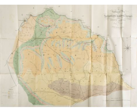
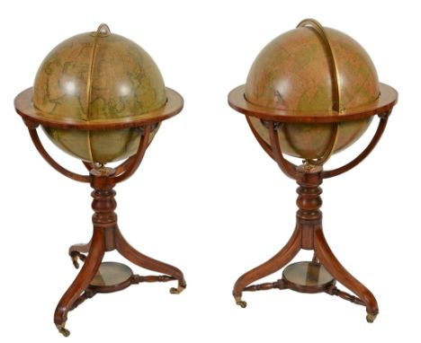
A fine pair of Victorian 18 inch floor-standing library globes J A fine pair of Victorian 18 inch floor-standing library globes J. Wyld, London, mid 19th century The terrestrial applied with twelve hand coloured printed gores and applied paper label A TERRESTRIAL GLOBE, Compiled from the latest, & MOST AUTHENTIC SOURCES, including all the recent, Geographical Discoveries, PUBLISHED BY J. WYLD, Charing Cross East, NEXT DOOR TO THE POST OFFICE, LONDON to North Pacific and extensively annotated with principal cities, towns, rivers, lakes, mountains and other significant topological features and with the British colonies colour-outlined in pink, the oceans with 'lines of Variation' and all notable islands annotated, as well as other commentary such as Yedo the Capital of Japan contains 1200,000 inhab'ts and is the residence of the Koubo or Seular Emporer, Meaco or residence of the Mikado or Spiritual Emperor contains 500000 inhab'ts and 6000 Temples, the Pacific with an analemma for the equation of time over table entitled TABLE OF THE ESTIMATED POPULATION OF THE WORLD.., by G.S. Brent Fellow of the Statistical Society of London , the equatorial line graduated in degrees, hours and minutes, the Celestial of conforming construction and labelled A, CELESTIAL GLOBE, Exhibiting the whole of the, Stars, Contained on the Catalogues of, PIAZZI, BRADLEY, HEVEHNS, MAYER, LA CAILLE & JOHNSON, the Double Stars from Sir W. Herschel and Struve, PUBLISHED BY J. WYLD, Charing Cross East, NEXT DOOR TO THE POST OFFICE, LONDON to lower hemisphere beside scale for star intensity and other explanations, the solstitial and equinoctial colures and equatorial graduated in degrees with the latter also in hours and minutes, the constellations depicted by mythical beasts and figures and appropriately labelled along with the stars in Latin, both spheres with engraved hour dials to poles and pivoted within brass meridian circle divided for degrees, resting in wooden stand with hand coloured paper horizon ring graduated in degrees in two directions, days of the month and houses of the Zodiac with names and symbols and also showing compass directions, supported on four curved quadrant supports to a baluster turned upright issuing three downswept supports with compass supported via three turned stretchers between, the feet with tapered brass cups and castors, 58.5cm (25ins) maximum diameter, 107cm (42ins) high. James Wyld (II) is recorded in Clifton, Gloria Directory of Scientific Instrument Makers 1550-1851 as a globe maker, map publisher and geographer who worked from several addresses in London including 454 West Strand (1837-1887), 454 Charing Cross East (1841-2), 2 Royal Exchange (1851) and Leicester Square (1848).
WALPOOLE, George Augustus: The New British Traveller or, A Complete Modern Universal Display of Great Britain and Ireland. L, Alex Hogg, nd, (Frontis dated 1794). Revises, corrects and Improved by W.H.Dalton. Folio, with many full page plates. CONDITION: Lacking the map and some plates; covers worn and detached. Sold as a collection of plates, with all faults
A map of the Parish of Hasketon in the County of Suffolk, surveyed by Dixon and Maitland 1838, copied by J Mc Lachlan, Stowmarket, signed by the Asst. Tithe Commisioner, "Martin", Also signed by two Tithe Commisioners and sealed, Approx 72" x 72" the map is backed with linen and contained in a metal tube, which while being externally rusty, has preserved same very well
-
109182 item(s)/page