We found 109182 price guide item(s) matching your search

Refine your search

Year

Filter by Price Range
  • List
  • Grid
  • 109182 item(s)
    /page

Lot 169

NO RESERVE Henty (G. A.) St. Bartholomew's Eve, double-page map, rebacked with original spine laid down, Blackie & Son, n.d.; With the Allies to Pekin, new endpapers, Blackie & Son, n.d., plates, occasional spotting, publisher's advertisements at end, original pictorial cloth, a little rubbed; and another by the same, 8vo (3)

Lot 2

Devon.- [Butcher (Edmund)] The Beauties of Sidmouth Displayed, second edition, 7 aquatint plates printed in bistre, folding engraved map with letterpress description, contemporary half calf, rubbed, upper cover detached, Sidmouth, John Wallis, [1816].

Lot 202

Footsteps to the Natural History of Beasts and Birds. Part 1., engraved illustrations, occasional faint off-setting, original wrappers, lower cover detached, rubbed and worn, 1806 § City Scenes; or A Peep into London for Children, 37 engraved plates, occasional spotting and soiling, lacking front free endpaper, previous owner's ink inscription, one or two short marginal tears, contemporary morocco-backed boards, rubbed and worn, loss to spine head, 1814 § Crosby's Universal Gazetteer in Miniature ..., second edition, folding map frontispiece, occasional short marginal tears, scattered faint spotting, contemporary calf, a little rubbed, 1809; and a later edition of Combe's 'Three Tours of Doctor Syntax', v.s. (4)

Lot 226

NO RESERVE Egyptology.- Champollion-Figeac (Jacques-Joseph) Egitto antico, translated by A. Francesco Falconetti, double column, half-title, engraved double-page map and 92 plates, some worming, mostly very small hole(s) or trace, but more pronounced in larger single trace to last 3 plates, some spotting or foxing, contemporary half black morocco, spine gilt, joints splitting, but holding firm, corners worn, rubbed, 8vo, Venice, Giuseppe Antonelli, 1840.⁂ Part of the 'L'universo o storia e descrizione di tutti i popoli' series published over a number of years, but complete in itself.

Lot 228

Middle East.- Layard (Austen H.) Discoveries in the Ruins of Nineveh and Babylon, first edition, half-title, folding frontispiece, 10 plates (most lithographs), 5 folding maps and plans, 1 with short tear, woodcut illustrations, occasional spotting, ex-library with ink-stamp to front pastedown and shelf-mark to title, previous owner's ink signature, cracked hinges, original cloth, short split to spine head, a little rubbed, slight bumping to corners and extremities, 1853 § Coldstream (J. N.) Greek Geometric Pottery, plates, folding map in pocket at end, adhesive marks to front free endpaper where label removed, original cloth, dust-jacket, a little rubbed, chipping to corners and spine extremities, 1968; and 2 others similar, 8vo & 4to (4)

Lot 3

NO RESERVE England.- London Map Directory: A Street Atlas of London & its Surroundings, first edition, colour-printed maps, slip-case, 1964 § Strong (Roy) Country Life 1897-1997: The English Arcadia, first edition, illustrations, 1996 § Noppen (J. G.) Royal Westminster, ink ownership inscriptions, occasional foxing, 1937, original boards or cloth, last two with dust-jackets; and a large quantity of others, topography and travel, v.s. (3 boxes)

Lot 1450

17th/18th century hand coloured map of the Sussex coast, by Greenvile Collins, modern frame, image 45cm x 28cm, and 1 other hand coloured map (2)

Lot 138

Various Cornish related volumes including Tregellas (WH) Tourists Guide to Cornwall 1878 with map; Boscawen's Charity Scheme brochure at Tregony 1859; Hawker - Cornish Ballads and Other Poems; A Cornish Harbour and others, etc

Lot 160

Kellys Directory of Cornwall, 1 vol 1893 with map

Lot 172

Rowe (S) The Panorama of Plymouth Tourist Guide, one vol, Plymouth 1821 with folding map; and Tavern Anecdotes and Reminiscences of the Origins of Signs, Clubs, Coffee Houses, London 1825 (2)

Lot 179

Redding (C) An Illustrated Itinerary of the County of Cornwall 1842; Johns (Rev CA) A Week at the Lizard 1848 with map; Tourist Guide to Cornwall; The Cornish Coast and Moors and others, etc

Lot 219

Rodd (EH) The Birds of Cornwall and the Scilly Islands, one vol, London 1880 with map; Penhallurick (RD) Birds of the Cornish Coast, 1969, dustjacket; and Ryves (BH) Bird Life in Cornwall 1948 (3)

Lot 253

Collyns (CP) Notes From the Chase of the Wild Red Deer in the Counties of Devon and Somerset 1862 and a Bacon's New Survey Map of Somerset, Dorset and parts of Wiltshire (2)

Lot 262

Langdon (AG) Old Cornish Crosses, one vol, 1896 with map, cloth

Lot 265

Tombleson's Upper Rhine, circa 1830, 70 engraved plates and rear folding map, half calf

Lot 267

Stockdale (FWL) Excursions in the County of Cornwall, one vol, London, 1824 with map, half calf

Lot 281

Beecham (John) Ashantee and the Gold Coast being a sketch of the history, social state and superstitions of the inhabitants of those countries, one vol, 1841, complete with folding map; and Ellis (AB) West African Stories, 1890 (2)

Lot 285

Barrett (William) The History and Antiquities of the City of Bristol, one vol, illus with copper plate engravings, 1789 with map (minus covers); Morgan (John) A Brief Historical Sketch of Bristol with the new picture of Clifton and Strangers' Guide, one vol, 1851 (2)

Lot 288

Polwhele (Rev R) The History of Cornwall, two vols together with supplement and map, bound as one, Falmouth/London 1803/04, half calf

Lot 335

Black's Tourist Guide to Devonshire and Cornwall including The Scilly Islands, one vol, 1855 with facsimile map

Lot 404

A 17th Century handcoloured map of Cornwall by Robert Morden, framed and glazed

Lot 851

A reproduction GWR engine drivers cap with brass badge and a reproduction GWR 1902 tin-plate coloured network map (2)

Lot 350

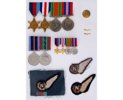
A WW2 campaign medal group together with two 'Caterpillar club' pins, to 152932 Flying Officer Edward Harold Ruston RAF, verso of both pins engraved 'F/O E.H. RUSTON'; the first example, an early issue with red glass cabochon 'eyes'', hinged under the head, clasp under the tail, unhallmarked but tests as 9ct gold; the second and later example with red enamel flat 'eyes', hinged under the tail, clasp under the head and with rank engraved above the name, presented together with a bar mounted campaign medal group comprising 1939-1945 Star, France and Germany Star, Defence Medal and War Medal with associated bar mounted dress set (replica), along with the Bomber Command medal and the Allied Prisoner of War medal, a single RAF coat button and three cushion embroidered RAF aircrew navigator's 'half brevet' cloth badges (16)Provenance: By direct descent from the recipientFootnote: The 57 Squadron Operational Record Book states that Flying Officer Ruston from Cambridgeshire was posted on to 57 Squadron on 27 June 1944. The squadron was based at East Kirkby, Lincolnshire at that time and during the war flew 5151 operational sorties with the loss of 172 aircraft. Avro Lancaster III JB318 DX-L At 22.56hrs on Tuesday 18th July 1944, 20 Lancaster bombers from 57 squadron took off from East Kirkby. They joined a formation of 89 more aircraft, and their mission was to destroy the Aulnoye railway junction at Revigny-sur-Ornain in France. Included in the 57 squadron group was Lancaster III 'L for leather', serial number JB318, identification DX-L, and its crew of 7 flown by Flt Lt J.A. 'The Bull' Bulcraig DFM. Also aboard was flight engineer Flt Sgt N.L.E. 'Windy' Gale DFM, navigator F/O E.H. 'Rusty' Ruston, wireless operator/air gunner Sgt T. Loughlin, air bomber F/O E.C. 'Robbie' Robson, mid upper gunner Sgt L.E.S. Manning and rear gunner Sgt F.J.D. 'Bert' Taylor. Soon after crossing the French coast - a little after 1am - they were picked out by German searchlights. Bulcraig put the Lancaster into a steep dive, but during this evasive action they lost the protection of the bomber stream and made themselves vulnerable to attack from enemy aircraft. A German JU88 night fighter approached from below, out of view of Lancaster’s gunners, and shot the plane down, killing four of the crew. Ruston, Taylor and Manning all bailed out, and the plane crashed in flames and blew up in a field near Bassevelle, between Paris and Reims. Manning, helped by the local French Resistance, went into hiding in a small café in La Trétoire (despite it being frequented by the Germans) until he was liberated by advancing American forces. Taylor went into hiding on a farm in Bussières and evaded capture until he too was liberated by the Allies. Ruston was captured by the Germans at Nanteuil-Sur-Marne on Sunday 23rd July and was imprisoned in the West Compound at Stalag Luft 1 prisoner of war camp in northern Germany. He remained there as prisoner 4967 until the camp was liberated by the Russians on 30th April 1945. The raid was a success, but the cost in men and aircraft was heavy - 24 aircraft and 129 lives were lost. East Kirkby lost 5 Lancasters (including DX-L) and 19 airmen. Today there is a permanent stone memorial to the crew of DX-L in the field on the crash site, built by the local residents. "...A brass plate fastened to a tree On it seven names stare out at me I press my fingers to the plate Thinking back to that night of fate That night of flame and naked fear When a stricken bomber crashed right here..." (Photograph of 57 Squadron at East Kirby, 1944, reproduced with kind permission of the 57 & 630 Squadrons’ Association. Credit for images of the memorial site at Bassevelle and map: Jacques Bodécot / Pierre Pécastaingts at Aérostèles) The Caterpillar club, formed in 1922, is an exclusive international association for people who have successfully used a parachute to save their lives by bailing out of a disabled aircraft. It was known as ‘The Elite Club that no one wanted to join, and whose members joined by accident”. Those who intentionally jump from aircraft, such as skydivers, are not accepted, and there are very strict conditions that need to be met. Potential members are required to apply with evidence of their descent. Following authentication, production of satisfactory evidence and independent corroboration of the event, applicants receive a certificate and a distinctive lapel pin modelled as a silkworm (as silk was originally used in the manufacture of parachutes). Each pin is individually engraved with the recipient’s name before presentation. Pins are not available for purchase by friends, colleagues or collectors, and the only other opportunity to obtain a genuine pin is on the very rare occasion when a previously issued example appears for sale, as in this case. The early versions were gold and had ‘ruby red’ glass eyes with the recipient's name and rank engraved in one line on the reverse. The later versions were silver gilt and had red enamel eyes with the recipient's name engraved on the reverse underneath their rank. This lot includes one of each variety. The early versions are particularly rare and extremely collectable. Members of the club included such famous names as Charles Lindbergh, WW2 flying ace Sir Douglas Bader and astronaut John Glenn.

Lot 1634

A vintage rolled map print of Narnia, published by Penguin Books 1972 - fading and tears

Lot 1675

William Hole: a gilt framed antique 1637 map of Hereford Shire - 29cm X 32.5cm visible

Lot 701

An educational use wall map of the British Isles - sold with a boxed tripod

Lot 595

Bank of Independent Pakistan, a political note denominated 1000 good wishes, c.1947, serial number F/AT 34000, Muhammad Ali Jinnah at left and map of India at right, crayon annotation on reverse, very fine and scarce unlisted, similar to India Pick 20 £80-£120

Lot 596

Bank of Pakistan, a political note denominated 1000, c.1947, serial number F/AT 7860, Name of Allah at right and Prophet Muhammad at left in Arabic, portrait of Jinnah and proposed map of India and Pakistan at centre, extremely fine, rare unlisted £80-£120

Lot 325

Large Moorcroft bottle shaped vase with trumpet neck, decorated with Kookaburra, Leaves and Berries, designed by Kerry Goodwin, Ltd.ed 10/30, impressed marks and painted map of Australia, 2008 and 2012, H54cm

Lot 226

Map of Cumberland, pen and ink drawing of a shepherd and sheep etc

Lot 79

A late 18th or early 19th century hand-coloured map, 'England & Wales by William Dorset', 76 cm x 63 cm glazed in a birds-eye maple frame.

Lot 89

BLAEU, Joannes (1596-1673)]. Surria Vernacule Surrey, a hand-coloured engraved map of Surrey, baroque title cartouche, coats-of-arms, framed and glazed, plate 38cm x 50cm

Lot 253

A framed and glazed 19th century map. 'L?OLANDA E IL REGNO BELGICO OVVERO I PAESI BASSI' by Bartolomeo Borghi (1750-1821). 50x40cm.

Lot 256

A framed and glazed hand coloured map of Ireland. Showing the principal Irish families and regions in Ireland. 71x58cm.

Lot 261

A framed and glazed 19th century map of Europa, published by Antonio Vallardi, 1867. It has illustrated details including ledger and scale. 56x68cm

Lot 70

A finely engraved and detailed 18th century map of Italy by Richard Seale. Published in Tindal's translation of Paul Rapin De Toras's History of England. The map features extensive detail on mainland Italy and also Sicily, Sardinia and Corsica. Coloured later. H.66 W.80cm

Lot 73

A framed and glazed antique map of 'Magnae Britanniae et Hiberniae tabula' by Willem Blaeu. H.62 W.73cm

Lot 891

Patterson's Roads; Direct and Principal Cross Roads in England and Wales with part of the Roads of Scotland, Seventeenth Edition with an Entirely New set of Maps by Edward Mogg, published in London 1824, containing a fold out general map of England and Wales at the front and eight other fold out detail maps throughout. This is a rare travelling bound copy with original folding leather wrap cover in overall good condition showing some signs of age / wear and some foxing, approx 22cm x 14cmWe combine postage on multiple winning lots and can ship worldwide. UK postage from £5.99, EU from £7.99, Rest of World from £9.99.

Lot 893

Diamond Gazetteer of Great Britain & Ireland Embellished with Three Maps of England, Ireland and Scotland, Fifth Edition, To which is now appended The Strangers Companion Through London and its Environs with additional fold out map, by E Bellchambers, published by Alan Bell and Co and T Tegg and Son, London 1835. A small original green board bound volume in overall good condition with some water marks measuring approximately only 8.5cm x 5.5cmWe combine postage on multiple winning lots and can ship worldwide. UK postage from £5.99, EU from £7.99, Rest of World from £9.99.

Lot 895

W H Smith and Sons Railway Map of The British Isles published by W H Smith and Son2s London Circa 1880, green hardback with a folding colour map, good overall condition showing light signs of age measuring approx 18.5cm x 10cm, the map when folded out measures approx 73.5cm x 86.5cmWe combine postage on multiple winning lots and can ship worldwide. UK postage from £5.99, EU from £7.99, Rest of World from £9.99.

Lot 168

John Harris - surveyed by Sir Jonas Moor (1617-1679) - a map of the Great Levell of the Fenns, extending into ye counties of Norfolk, Suffolk, Northampton, Lincoln, Cambridge, Huntingdon and the Isle of Ely, 17th century, hand coloured 39cm x 52cm in a glazed frame

Lot 25

A COLLECTION OF EIGHT WATERCOLOURS AND A MAP (8)

Lot 54

FOUR FRAMED AND GLAZED PICTURES TO INCLUDE A VINTAGE JAPANESE MAP

Lot 261

A map of Huntingdon, after C. and J. Greenwood

Lot 100

Collection of 1950s crime scene black and white press office photographs. There are approx. 70 folders each contains between 1 -9 photos Each folder has photos of each crime from RTAs to murders, also a Port of London Authority book circa 1960's with fold out map in the back, and a typed instructional folder called 'photography in police work' More photos to follow

Lot 166

A framed watercolour of Clifftown Parade, Southend by Frank Alwin 1981, frame size 64 x 47cm. Together with a framed and signed print of Southend by Richard Argent, a Southend area map and a pencil signed limited edition 105/750 print of Marine parade Southend.

Lot 171

A framed hand coloured reproduction map of Leigh on Sea, frame size 67 x 54cm.

Lot 172

A framed map of the port of London, frame size 91 x 41cm.

Lot 478

OLD FRAMED STREET MAP OF BELFAST

Lot 642

Six old American maps, comprising Thomas Kitchin Snr 'A new map of British Dominions in North America', published 1763, and engraved for the history of the war in the annual register, 25cm x 30.5cm; Kitchin's 'Map of Virginia, North Carolina and the northern part of South Carolina', 27.5cm x 34cm; Kitchin's 'Map of the Province of West Florida', 21cm x 26.5cm; Kitchin's 'Seat of War in the environs of Philadelphia', 21cm x 26.5cm; 'Accurate map of the English Colonies in North America, bordering on the river Ohio', 24cm x 24.5cm; and Emmanuel Bowen 'North America', published 1763, with parts 'undis covered' (sic), 19cm x 24cm

Lot 1067

Postcards, a good mixed age foreign collection of approx. 400 cards arranged by countries from Puerto Rico to Zambia inc. Mozambique, Netherlands, Nigeria, Zanzibar, New Zealand, Vietnam, Israel, Portugal etc with scenic views, royalty, villages, rail, Maoris, ethnic, dog cart, stamp and coin card, map, good street scenes, costume etc (mixed condition)

Lot 1129

Postcards, a mixed UK topographical collection of approx. 272 cards with 172 Cumbria and 100 cards of Shrewsbury Salop, RPs include map of Keswick area, Main St Hawkshead, High St Longtown, Seatoller Borrowdale, Church Walk Ulverston. Also printed Princes St Ulverston, rail officials (3) etc (mixed condition)

Lot 1251

Postcards, Military, a selection of 4 Boer War related cards inc., coloured chromo Grass Aus style map card showing Transvaal and Orange Free State with portraits of Kruger and Joubert (1900), sitting portraits of General de Wit brandishing a rifle, 'Wiping something off the Slate' 120 day siege Paardeberg and Ladysmith illustrated by Harry Payne, and French political cartoon chamberlains 'Theatre de la Guerre' a muleteer cursing his mules (mainly gd) (4)

Lot 1263

Postcard, Advertising, Recruiting Poster, Join The Army, with map of life’s highway, (gd/vg) (1)

Lot 1276

Postcard, Advertising, The Harris Cycle of Hill Cross Works, Coventry, artist drawn image showing cyclist against backdrop of map of the UK (unused, vg) (1)

Lot 216

Antarctic Exploration, a quantity of books, stamp sheets, a laminated map, ephemera etc, books include Antarctic Mail by Dr Fred Goldberg, The Endurance by Caroline Alexander, South with Endurance illustrated with the photographs of Frank Hurley, a brochure from the Royal Philatelic Society of London for the Polar Group Display 31 May 2018, a Westminster Abbey programme from the Centenary Service of Thanksgiving for the courage & endurance of Sir Ernest Shackleton & His Men 20 May 2016 & others. The lot also includes two original extracts from French magazines, one showing a scene from Shackleton's expedition dated 13 Feb 1921, the other showing Shackleton with dog, a selection of presentation photocopied information sheets, DVD's & other items (1 large box) (mainly gd/vg)

Lot 244

Rail Ephemera, to include 9 small Warning/Information signs (Not Drinking Water, To Open Window Press & Pull Down, Please Do Not Use Lavatory When Train Is Standing At A Station etc.), The District Railway Map of London 6th Edition circa 1898, 4 albums containing an assortment of rail ephemera to include G.W.R. and Southern Railway labels (Milk, Eggs), 1970s B.R. forms (train Preparation Form, Guard's Delay Slip, Driver's Slip, Train Lists etc.), 1958 Notice of Royal Trains leaflet, 3 reproduction rail posters in 2 original carriage frames, rail calendars etc. (gen gd) qty

Lot 246

Bus Timetables and Maps, dating from the 1930s to the 1970s to include 40+ folding maps (Central Buses, Green Line, Bus Map, London Underground) and approx. 60 'Complete Local Road and Rail Timetables' dating from the 1960s and 70s all London and provinces (gen gd) (100+)

Lot 276

London Underground Carriage Maps, to comprise Piccadilly (2), Bakerloo, District (3), Northern, Central (2), Metropolitan (2), Underground map (some on paper, some self-adhesive) plus 4 Bakerloo roundel stickers (gen gd) (16)

Lot 363

Ephemera, approx. 200 items dating from the mid 19thC to the mid 20thC to include 1947 B.O.A.C. timetable, 1852 map of Sussex on linen, bookmarks, Victorian Lostwithiel writing paper, military English/Urdu phrase books, 1920 Swan Mechanical Toys booklet, 3 small 1970s watercolour portraits, Illustrated London News Souvenir Edition QV Diamond Jubilee, WW2 Military Mess tickets etc. (gen gd) (approx. 200)

Loading...Loading...
  • 109182 item(s)
    /page

Recently Viewed Lots