We found 109182 price guide item(s) matching your search

Refine your search

Year

Filter by Price Range
  • List
  • Grid
  • 109182 item(s)
    /page

Lot 492

Oak framed advertising print for Wild Woodbine with gilt slip and an unframed London Regional Underground map together with and a Concert Hall poster, unframed

Lot 232

1940 German World War II Luftwaffe map together with three other items

Lot 1789

Framed coloured map of Northumberland, published by Longman, Rees, Orme, Brown and Co. 1836

Lot 1908

18th Century map, ' The Wards of Farrington Within and Baynards Castle ' including St. Paul's Cheapside and Ludgate Street, London in an oak frame, 12ins x 15ins

Lot 2051

Large hand coloured map of Spain and Portugal after the antique, gilt framed

Lot 1776

Large gilt framed colour print, ' The Rugby Match ' together with a framed coloured mezzotint, portrait of Napoleon on horseback and two framed prints, ' The Historic Map of Scotland ' and ' Historical Map of England and Wales

Lot 634

Late 19th Century map, South Eastern railway main line from Redhill to Edenbridge, No. 9, leather covered folding canvas backed having hand coloured details and later hand written workings, inscribed on the front ' Manager and Securities Office ' (a/f), 6m 40cms long

Lot 166

NINETEENTH CENTURY HAND COLOURED MAP OF ITALY 9 1/2" X 7 1/2" (24.1cm x 19.1cm) framed and glazed

Lot 333

NINETEENTH CENTURY HAND COLOURED MAP OF THE COUNTY PALATINE OF CHESTER AND ANOTHER

Lot 254

A print depicting a map of Woodbridge

Lot 435

Great Western Railway framed print "Country Connection" by Don Breckon and a G.W.R pre 1948 route map.

Lot 109

MAP OF LONDON, river Thames historical map framed.

Lot 255

FLASK. 8.25ins tall. Greeny aqua glass, handled (hand applied), overall basket weave effect with map of Australia shape to take label. District diamond registry mark to base. Very good. (9/10) NR

Lot 1128

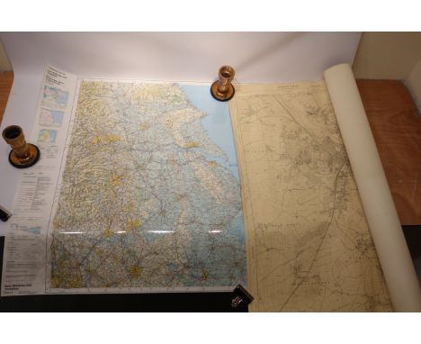
'United States of North America, Upper & Lower Canada New Bunswick, Nova Scotia & British Colombia. Mexico, Cuba, Jamaica, St.Domingo and the Bahama Islands', map dated at the beginning of the Civil War June 1861 by T Ettling from the London Illustrated News 78cm x 108cm Condition Report Click here for further images, condition, auction times & delivery costs

Lot 1131

'New Map of Yorkshire', pub. Alexander Hogg (1778-1824), 21cm x 33cm Condition Report Click here for further images, condition, auction times & delivery costs

Lot 1125

Geological Map of England & Wales and one other of Scotland and the North of England Condition Report Click here for further images, condition, auction times & delivery costs

Lot 1125A

'The Silver Map Of Great Britain' with Boundary Lines and the Coats of Arms of the Historic Counties, hallmarked silver with embellished with 24ct gold, limited edition no. 14/3000 for the Golden Jubilee, 1977 with certificate, framed, 50cm x 70cm Condition Report Click here for further images, condition, auction times & delivery costs
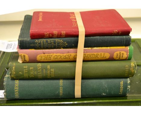
Lot 1153

Kelly's Directory of Yorkshire. North East Ridings with The City of York , with map, cloth bound 1901 Condition Report Click here for further images, condition, auction times & delivery costs

Lot 1130

An Accurate Map of the North Riding of Yorkshire divided into its Wapontakes by Eman Bowen, 18th century map with hand coloured detail, printed John Bowles & Son Cornhill, 54cm x 70cm Condition Report Click here for further images, condition, auction times & delivery costs

Lot 1129

'Scotland & Islands', 1815 colour map on linen drawn and engraved after Hewitt for Thompson's New General Atlas 67cm x 80cm Condition Report Click here for further images, condition, auction times & delivery costs

Lot 1124

Ordnance Survey Map East Midlands and Yorkshire, colour laminate 92cm x 126cm and one other York and surrounding area115cm x 102cm (2) Condition Report Click here for further images, condition, auction times & delivery costs

Lot 50

J.F. DARLEY (19TH CENTURY), Fishing Boats by a Harbour, and Fishing Boats at Sea, a pair, both W.C., and signed lower left, 4'' (10cm)h x 7'' (18cm); together with a small map of Ireland by Thomas Bowen, 12'' (30cm)h x 7.75'' (20cm). (3)

Lot 1057

Framed memorial sampler bearing a date 1850, embroidered with a map of Yorkshire, another of the Coronation, six 19th century alphabet samplers (four unframed), framed sampler by Mary Green with verse, two others (a.f.), reproduction folio map of Huddersfield, prints etc (qty)

Lot 1036

Two Isle of Wight guides: Nelson's Handbook 1862, London, 8vo. original limp cloth gilt, with folding colour map and frontis. of Osbourne House, other plates, contemp. ownership inscription to title [&] Ward (C.S.) Thorough Guide Series, 1906, New Revised Edition, 8vo. red cloth gilt with eight maps and plans by Bartholomew; two books of Irish interest incl. Leech (John, Illustrator) (Hole, S. Reynolds) A Little Tour of Ireland... By An Oxonian, 1892, London, Edward Arnold, New Edition, publisher's adverts to rear [&] Stone (J. Harris) Connemara, 1906, L., Health Resort Publishing Co., photographic illus., both large 8vo. in green cloth; plus Brooke (Jocelyn) The Goose Cathedral, 1950, Bodley Head, First edition in green cloth with d.j. (5)

Lot 1034

Speed (John) [Isle of Man map] The Isle of Man Exactly described, and into Several Parish..., [1743], London, Henry Overton, outline colour by hand, the map flanked by elaborate strapwork cartouches and scales; visible margins, in a modern frame.

Lot 258

A Mid 19th Century map of Devonshire from the Complete & Universal dictionary of the English Language

Lot 101

Two medals regarding Rhodesia and Zimbabwe, a map and a selection of map stickers

Lot 82

'East Riding of Yorkshire', 20th century map, two 19th Century hand coloured engravings of Hull and another Hull engraving max 19cm x 23cm (4) Condition Report Click here for further images, condition, auction times & delivery costs

Lot 201

Two early 20th century mahogany squares, together with assorted items to include: WWII map case, woodworking tools, an oak desk stand, biscuit barrels and other items.

Lot 389

After L. S. Lowry, four framed and glazed prints, together with a late 19th century map of Bedfordshire and a quantity of other pictures and prints, various sizes and various mediums.

Lot 204

Saxons map of Wiltshire original dated 1576

Lot 172

A Time-O'Day Purest Soap world map mechanical showcard, 9 3/4 x 12".

Lot 162

An Associated Motorway Express Coach Routes map of "The North & Midlands to South Coast", 20 x 19".

Lot 16

A British Road Parcels Limited pictorial Main Road Map of Great Britain.

Lot 1186

Large cast Swastika wall mount NSDAP marked to rear. Central boss map of Germany with rivers and cities located. Dated 1941 cast to centre.

Lot 1151

German Army (Heer) brown leather map case (field issue) no maker marks.

Lot 121

A First World War boxwood map board by Hugh Rees Ltd, London & Camberley

Lot 370

Map of the World - an early 19th century white metal dual-faced medal, ca 1820, unsigned, possibly by T Halliday, 7.4 cm (diameter), very fine - Est £40 - £60

Lot 2695

A GEORGIAN ROLLED PAPERFRAME CONTAINING AN OVAL NEEDLEWORK MAP OF ENGLAND APPROX 60 X 50 CM

Lot 203

A Scarborough's map of England and Wales

Lot 566

An ivory map rule, a Celtic plaster cross, 2 dip pens, a bone fist and an old 'shot' ladle

Lot 854

TWO FRAMED JAPANESE POSTCARDS FROM 1905each 13.5cm x 9cm; together with a 'Map of Asia' attributed to Samuel John Neele (1758-1842)11cm x 7.5cm and a 'Map of Arabia' from James Wyld, Atlas of the World, London, c.1864, 27cm x 22cm, each mounted, framed and under glass (3)

Lot 975

BLAEU, J., HONAN PROVINCE17th century hand-coloured map, 48.5cm x 40cm, mounted, framed and under glass

Lot 508

Vintage Johnson's Autokit with contents together with a 19th Century Ordnance Survey map of Kent etc.

Lot 744

19th Century pbl. Greenwood & Co 'Map of the County of Sussex from An Actual Survey Made in the Years 1823 and 1824 ...', 22.5' x 27.25'.

Lot 280

FIVE ASSORTED WOODEN JIG-SAW PUZZLES, includes map of England and Wales

Lot 320

A vintage early 20th Century wallhanging Scarborough's map of England & Wales

Lot 272

BACON'S illustrated MAP of YORKSHIRE 1876 by EDWARD WELLER F.R.G.S  72cm by 95.5cm - in narrow oak frame

Lot 541

Miliaria Anglica - two map prints of the North East of Britain and the South West - 36 x 46cm, glass a/f

Lot 773

An old map of Bridgeton and surrounding area on the Delaware River

Lot 540

A map of Gloucestershire 1712 by Herman Moll from The Ancient and Present State of Gloucestershire by Sir R Atkyns - unframed

Lot 914

A 1953 Coronation sampler and a needlework map of Gloucester

Lot 772

A 17th century map of Warwickshire by Wm Kip and Christopher Saxton - 31 x 37cm

Lot 1557

Two Hundred and Fifty Years of Map Making in the County of Sussex, a collection of reproduction maps published between 1575 and 1825; together with a plan of the Cities of London and Westminster, in twenty-four sheets, all unframed.

Lot 378

AFTER JOHN SPEEDE "Darbieshire", an engraved map, hand coloured, framed and glazed, 41 x 54cms.

Lot 379

AFTER R. MORDEN "A New Map of England", engraved map, hand coloured, 46 x 57cms.

Lot 380

AFTER EMANUEL BOWEN The East Riding of Yorkshire, engraved map, hand coloured, framed and glazed, 52.5 x 65cms.

Lot 377

AFTER J. ARCHER Derbyshire, engraved map, later coloured, 26 x 21cms. Nine Other Maps, similar, and two further reproduction examples. (12)

Lot 381

AFTER D'ANVILLE Orbis Verteribus Notus (The Ancient World), engraved map, hand coloured, framed and glazed, 53 x 73cms.

Lot 286

17th c. leatherbound Bible (1682) with inserted Common Prayers including the "newly translated Old & New Testaments" printed at the Theatre and are sold by Moses Pitt at the Angel in St Pauls Churchyard, London "with copperplate inscriptions and containing an old printed linen map of the "Travels & Voyages of St Paul"

Loading...Loading...
  • 109182 item(s)
    /page

Recently Viewed Lots