Co. Kilkenny: Tighe (Wm.) Statistical Observations Relative to the County of Kilkenny, 8vo D. 1802, First Edn., some fold. maps & plts. cont., hf. calf; Ryland (Rev. R.H.) The History, Topography and Antiquities of the County and City of Waterford, 8vo L. 1824, First Edn. Lg. fold. cold. map frontis, 6 engd. plts. & maps, mostly lg. fold. hf. mor. worn. As a coll of maps & plts. (2)
We found 109182 price guide item(s) matching your search
There are 109182 lots that match your search criteria. Subscribe now to get instant access to the full price guide service.
Click here to subscribe- List
- Grid
-
109182 item(s)/page
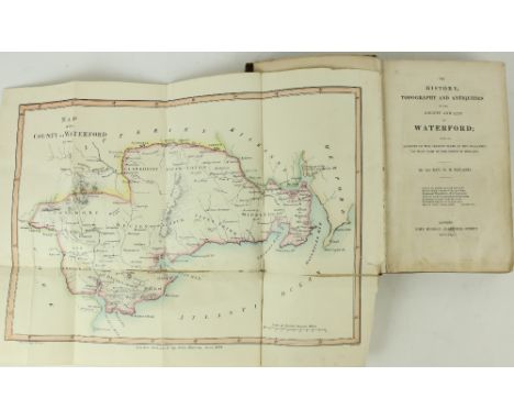
Box of Material Relating to Land Sales, mostly in Co. TipperaryRentals and Particulars of Land Sales in:· Cappagh & Graigacurra and other lands, Co. Tipp, 1871 + map· Ballyqirkeen, Co Tipp, 1890· Bawnmore, Co Tipp, 1892· Kilmoylan and other lands in Co. Limerick, 1903· A farm in Co. Tipperary in the case of Hogan v Doherty, 1901· Part of Knocknascrow, Co Cork, 1898Broadsides of different sizes (the largest 89 x 57 cm), some in colour, for sales of:· Licensed premises and 5 cottages in Clogheen, 1911· Hardware store in Clonmel, 1914· House and Lands in Carrigeen, 1900· Bansha House, late Rev John Cooney PP, 1885· Crops of Tinnahinch nr Cappawhite, in re Purefoy v Sadleir. 1885· Lands in Ballynaraha, 1912· Land at Monmore, 1905· Business premises in Tipperary, exrs Charles Peare, 1907· Residential holding at Clonmaine, Donaskeigh, 1914· Lands at Ballyryan West, 1898· Various lands in Knockaneduff, Acraboy, Boreen, Ballykisteen, Goatenstown, 1900· Aughballydeag, 2 extensive holdings, horses, cattle, crops, machinery etc 1908· Premises in Tipperary, 1905· 2 valuable farms at Farranlahassery and Cloghabreedy, Tuesday 14 Feb [1933 or 1939]· Property in Cahir, 1912· Residential holding at Aughballydeag, with horses,cattle, machinery, implements,1910· Residential holding at Riversdale, Horse and Jockey, 1902· Business house and premises, Tipperary, 1897· Lands in Ballynaraha, 1912· House and lands at Carrigeen, 1900· Part of lands of Ballyryan West, 1898· Farm at Whitechurch, 1893· House and premises at Cappawhite, 1925· Farm at Loughfeedora, 1898· High Court announcement that Arthur Smith-Barry is entitled to hold and receive the tolls of the fairs and markets in Tipperary, 1891· Notice of availability for inspection of rate books, Millstreet union [Co. Cork], 1897Also:Tithe applotment book for Nohoval parish, Co Tipperary, 29 January 1829. Certified copy in the custody of the Land Commission. Large folio 23 ff.Lists of those entitled to vote in the elections for 1905 in the Poor Law Union of Nenagh (+ 2 others).A miscellaneous collection of newspapers, late 19c and early 20c.As an Archive. (1)
Leslie (Rev. James B.) Ardfert & Aghadoe, Clergy and Parishes, roy 8vo D. 1940. First Edn., port. frontis. Pres. Copy, inscribed & with orig. A.L.s. from author, loosely inserted; also The Diocese of Ross its Bishops, Clergy and Parishes, Cork 1936. First Edn., fold. map, both orig. cloth. (2)
Very Large Hand-Coloured Map of IrelandMap: Thompson New General Atlas - Hewitt (N.R.) Northern and Southern Parts of Ireland, 2 large maps, together approx. 100cms x 64cms (39 1.2" x 25") hand coloured in full, with 2 engraved vignettes, published 1817. In very fine condition, unframed. As a map, w.a.f. (2)
Bound for William Stawell, Esq.Bindings: Watson Stewart (John) The Treble Almanack for 1806 and 1810, 2 vols. D. 1806 and 1810. First Edn., each containing Gentleman's & Citizen's Almanack; The English Registry, and Wilson's Dublin Directory, Volume for 1810 only with map, both in extremely fine full cont. crimson mor. profusely tooled with various elaborate designs, flowers, sprays etc., the 1806 volume with lyres and arrows, etc., and each cover inscribed William Stawell, Esq. Both in fine condition. (2)
Box: Kerry interest mostly: Hall (Mr. & Mrs.) A Week in Killarney, 4to L. 1850 First Edn., engd. frontis & other engd. plts. decor. title, fold. map text illus., in fine full mor tooled gilt decor. V. good copy; King (Jeremiah) King's History of Kerry, Parts I - VI, 6 parts, 8vo Wexford 1912 - 1918, & Tralee, orig. ptd. wrappers; Graves (A.P.) Songs of Killarney, L. 1873; Rowan (A.B.) Lake Lore: or, An Antiquarian Guide to Some of the Ruins and Recollections of Killarney, D. 1853. First Edn., cloth; & 3 others on Killarney; plus Brennan-Whitmore (W.J.) With the Irish in Frongoch, D. 1917. First Edn., illus; Carbery's Annual, 1963, wrappers; Catholic Emancipation Centenary Record, 1929, illus. wrappers; and other items. A small box. As a lot, w.a.f. (1)
D'Alton (John) The History of Drogheda, with its Environs, 2 vols. D. 1844. First Edn., add. engd. title Vol. I, 2 frontis & 21 engd. plts. & maps, list of subs., orig. cloth, good; also Lenihan (Maurice) Limerick; its History and Antiquities, roy 8vo D. 1866. First Edn., fold. map frontis & 4 plts. text illus., orig. cloth, joints cracked. (3)
War Maps: Cary (John) A Map of the Present Seat of War on the Northern Part of France, including the Netherlands Part of Germany etc., Lg. engd. map approx. 26" x 33 1/2" (66cms 85cms), hand coloured in outline, published London July 1793; Sevastopol showing the Position of Allied Camps and The Batteries, lg. hand coloured map, approx. 69cms x 102cms (27" x 40") published Lond. 1854; and Johnston's War Map of Turkey in Europe with Latest Divisions and Railways 1876, coloured map approx. 53cms x 66cms (21" x 26") linen backed. As a coll. of maps, w.a.f. (3)
American Map: Wyld (James) Map of the Colony of New Caledonia and the British & American Territory West of the Rocky Mountains including Vancouver's Island and The Gold Fields, Lg. engraved map approx. 52cms x 70cms (20 1/2" x 27 1/2") hd. cold. in outline, published London July 16th, 1858, with two inset maps. (1)
Engraved Maps: Controret (Kong Gen. Landrm) Karta ofver Langswagarner uti Sverige och Norrige, 1831 approx. 91cms x 63cms (36" x 25"), hd. cold. linen backed folding map; Johnston (K.) Sweden and Norway (Scandinavia) fold. linen backed cold. map, Edinburgh c. 1850; Whitelock - Le Scandinevie, Lithograph au Bureau de l'etat major de l'Armee, hd. cold. & folding linen backed, 1837, approx. 94cms x 68cms (39" x 27"), in slip case; Charot (Victor) Carte Generale d'Europe - Nouvelle Carte des Chemins de Fer de l'Europe, lg. folding linen backed map, hand coloured, Paris 1866, approx. 71cms x 98cmns (28" x 38 1/2"), cloth folder. All good. As maps, w.a.f. (4)
Binding: O'Sullivan (Donal) Carolan - The Life Times and Music of an Irish Harper, 2 vols. in one, 4to L. 1958. First Edn., 2 fold. maps, cold. frontis vol. I, & plts., qtr. vellum backed buckram, gilt; O'Mahony (J.)ed. Poetry and Legendary Ballads of the South of Ireland, 4to Cork 1894. First Series, some illus., recent qtr. crushed green levant, mor. labels, v. good; Hogan (Ed.) Onomasticon Goedelicum, 4to d. 1910. First Edn., map frontis orig. cloth. (3)
Travel in Kerry, Clare, Connemara & MayoBecker (Bernard H.) Disturbed Ireland: Being the Letters Written during the Winter of 1880 - 81, 8vo L. 1881. First Edn., route map frontis & 1 lg. fold. sim. ditto, hd. cold. in outline, advert leaf at end, orig. decor. cloth. V. good clean copy. Rare. (1)
Salmon - A New Geographical and Historical Grammar: 8vo D. 1752. Third Edn., fold. map frontis., red & bl. title, engd. plt. & 21 fold. maps, some tears (one with some loss), cont. calf; A Compendious History of Captain Cook's First and Second Voyages, sm. 8vo L. 1784, cont. calf; Fischer (F.A.) Travels in Spain, 8vo L. 1802, lacks fold. map,hf. calf. (3)
Irish Travel: Barrow (John) A Tour Round Ireland .. in the Autumn of 1835, 8vo L. 1836. First Edn., vign. title, fold. map, frontis & plts., hf. green mor.; Weld (C.H.) Vacations in Ireland, 8vo L. 1857. First Edn. litho frontis, recent qtr. calf, mor. label; [Barry (Wm. N.)] A Walking Tour Round Ireland in 1865, 8vo L. 1865. First Edn., fold. map frontis orig. cloth, all v. good; & 2 others, Irish Travel. (5)
Clark (Rob. Starling), Sowerby (A. de C.) Through Shen-Kan, The Account of the Clark Expedition in North China, 1908 - 9. 4to L. 1912. First Edn. map frontis, fold. map in pocket at end, 6 mtd. cold. plts. & 69 photo illus on 58 plts. uncut, & partly unopened, orig. decor. yellow buckram. Good. (1)
Maps: Bellin (S.) Carte du Cours du Fleuve de Saint Laurent, Depuis Quebec Jusqúa la mer en deux feuilles dressee au Deposts des cartes et Plans de la Marine, Quebec 1761, contemp. hand colouring framed; together with a double sheet 19th Century Atlas Map No. 3 - Southern Hemisphere, framed. As maps, w.a.f. (2)
Signed Limited EditionPeary (Robert E.) The North Pole, lg. thick 4to L. 1910. Special Lim. Edition, 500 Copies only, Signed by Author, R.E. Peary & R.A. Bartlett Lg. fold. map (torn from binding,no loss) with 116 mtd. photographic plates, some light spotting, but internally clean, uncut, orig. publisher's vellum cloth with gilt medallion on front cover, but some stains. (1)
Signed by Captain Spindler[Casement (Sir R.)] Spindler (Capt. Karl) Das Gehaimnisvolle Schiff, 8vo Berlin 1921. Rare First Edn., Signed by the Author, port. frontis fold. map & illus., & with many news cuttings loosely inserted, orig. gilt decor. cloth. Rare.* Spindler captained The Aud which attempted to land arms for The Volunteers in Kerry in 1916. This book was later published in English as "The Mystery of the Casement Ship," Berlin 1931. (1)
Co. Westmeath: Manuscript Map - Byron (Sam.) cartographer, A Survey of Ballrowan, Kerynstown, & Clonecully in the Barony of Farbill, Parish of Killucan and County of Westmeath The Estate of the Rt. Hon. Hercules Langford Rowley, 1787. Lg. hd. cold. manuscript map, linen back & rolled. With descriptions of the Different holdings with acreage; 1 other item sim. As a m/ss., w.a.f. (2)
I.A.S.: Hardiman (J.)ed. A Chorographical Description of West or H'Iar Connaught, ... by Roderic O'Flaherty. 4to D. 1846. First Edn.,, map frontis; also O'Donovan (J.)ed. The Tribes and Customs of Hy-Many, Commonly Called O'Kelly's Country. 4to D. 1843. First Edn., map frontis & fold. table, both uniform cloth. (2)
Illustrated London News, June 1st, 1861Map: Euling (T.) Map of the United States of North America, Upper and Lower Canada, New Brunswick, Nova Scotia and British Columbia, Mexico, Cuba, Jamaica, St. Domingo and the Bahama Islands, V. large coloured folding map, approx. 72cms x 97cms (28" x 38") issued with Illus. London News, June 1st, 1861. V. good, as a map, w.a.f. (1)
Barker (W. Burckhardt) Lares and Penates: or, Cilicia and its Governors, ... ed. by W.F. Ainsworth. 8vo L. 1853. Frontis, fold. map & 4 plts., text illus. thro.-out, cont. calf, tooled gilt spine; St. John (J.A.) Egypt and Nubia, their Scenery and their People. 8vo L. n.d., hf. title, vign. title, text illus., cont. full calf, tooled gilt spine, mor. labels. V. good. (2)
Irish Travel: [Thackeray] The Irish Sketch-Book, 2 vols. 8vo L. 1845. Second Edn., 2 frontis, text illus., cloth; Hall (Mr. & Mrs. S.C.) Hand-Books for Ireland - The West and Connemara, and The South and Killarney, 2 vols. sm. 8vo L. 1853. 2 engd. frontis & 2 engd maps, text illus, a.e.g., uniform gilt cloth; The Pleasure Tours in Ireland, 8vo Edin. 1827. Lg. fold. map & 1 other plan, engd. plts. hf. mor. As a lot, w.a.f. (1)
Co. Derry: Colby (Col. Thos.) Ordnance Survey of the County of Londonderry, Part I [All Published] D. 1837, First Edn., hd. cold. map & other fold. maps etc., also hd. cold. & other plts., text illus. etc. orig. cloth, v. good; [Phillips (Sir Thos.)] Londonderry and the London Companies 1609 -1629, sm. folio Belfast (H.M.S.O.) 1928. First Edn., cold. & other maps, orig. cloth, v. good. (2)
M'Parlan (James) Statistical Survey of the County of Sligo..., Under Direction of Dublin Society, 8vo D. 1802. First Edn., fold. map, lacks title page, recent mor. backed boards; Dubourdieu (Rev. J.) Statistical Survey of the County of Antrim, Vol. II only, 8vo D. 1812. Plan of Belfast & 10 sepia plts. (some fold.) hf. mor.; & 2 other items, odd vols., one with numerous engd. plts. As a lot, w.a.f. (4)
Travel: Villiers-Stuart of Dromana (H.) Adventures Amidst The Equatorial Forests and Rivers of South America; also in the West Indies and the Wilds of Florida to which is added Jamaica Revisited, lg. 4to L. (J. Murray) 1891, First Edn., fold. map frontis., hf. title, dedit., 22 plts. (some fold.) complete, decorated gilt pictorial blue cloth. Good. (1)
-
109182 item(s)/page