We found 109182 price guide item(s) matching your search
There are 109182 lots that match your search criteria. Subscribe now to get instant access to the full price guide service.
Click here to subscribe- List
- Grid
-
109182 item(s)/page


Lot 31
Historische Kupferstichkarte Indien, 18.Jh. - "India Orientalis, cum adjacentibus insulis nova delineatione ob oculos profita per Matthaeum Seutter". Indien und Australien. Aufwändige Bildkartusche mit Neptun, Menschen, Putten und Tieren. Handkoloriert, Maße 48,5 x 57 cm mit Mittelfalz, kleine Risse, Flecken und Verfärbungen, wellig, mit Alters- und Gebrauchsspuren.| Historical copper engraved map of India, 18th century - "India Orientalis, cum adjacentibus insulis nova delineatione ob oculos profita per Matthaeum Seutter". India and Australia. Elaborate image cartouche with Neptune, people, putti and animals. Handcoloured, dimensions 48.5 x 57 cm with center fold, small tears, stains and discolouration, wavy, with signs of age and usage.

Lot 36
Hist. Kupferstichlandkarte Fränkischer Kreis 18.Jh - 1 x Fränkischer Kreis "Circulus Franconicus in quo continentur Episcopat. Würtzburgens. Bambergensis et Aichstadiensis..", M. Seutter, oben rechts Karte Grafschaft Erbach i. Odenwald. Mit Mittelfalz, Maße 62cm x 54cm. Mit Alters-und Gebrauchsspuren, Verfärbungen, Verschmutzungen, Knicke, Risse.| Hist. copper engraved map Franconian county, 18.cent. - 1 x Franconian County "Circulus Franconicus in quo continentur Episcopat. Würtzburgens.Bambergensis et Aichstadiensis..", M. Seutter, top right map county Erbach i. Odenwald. With centerfold, dimensions 62cm x 54cm. With signs of age and use, discoloration, soiling, creases, tears.

Lot 38
Historische Kupferstichkarte Deutschland, 19.Jh. - "Neuste Post Karte von ganz Deutschland und dessen angrenzenden Ländern". M.A. Lotter, Augsburg. Handkolorit. Maße 64 x 54 cm. Alters- und Gebrauchsspuren, kleine Löcher, fleckig, verschmutzt, Alters- und Gebrauchsspuren.| Historical copperplate map of Germany, 19th c. - "Neuste Post Karte von ganz Deutschland und dessen angrenzenden Ländern". M.A. Lotter, Augsburg. Hand coloring. Measures 64 x 54 cm. Signs of age and use, Small holes, spotted, soiled, signs of age and use.

Lot 39
Historische Kupferstichlandkarten Frankreich und Korsika, 18.Jh. 1 x Ordensprovinzen, Klöster und Wallfahrtsorte der Benediktiner in Frankreich "Gallia benedictina seu Abbatiae & Prioratus tam Monachorum quam Monialium Ord. S. Benedicti (...), Carl Rupert und Johann Christoph Homann, erschienen bei Homann Erben. Maße 63cm x 54cm mit Mittelfalz. 1 x Korsika "Insulae Corsicae olim Cyrnus dictae novissima facies chorographice tradita", Homann Erben. Titelkartusche oben rechts, Nebenkarte oben links Stadtplan von Bastia. Mit Mittelfalz, Maße 51 x 42 cm. Mit Alters-und Gebrauchsspuren, Risse, Flecken, Verfärbungen, Knicke, restauriert an Mittelfalz.| Historical copper engraved map of France and Corsica, 18th century - 1 x Provinces, Monasteries and Shrines of the Benedictines in France "Gallia benedictina seu Abbatiae & Prioratus tam Monachorum quam Monialium Ord. S. Benedicti (...), Carl Rupert and Johann Christoph Homann, published by Homanns Erben. Dimensions 63cm x 54cm with centerfold. 1 x Corsica "Insulae Corsicae olim Cyrnus dictae novissima facies chorographice tradita", Homann heirs. Title cartouche top right, secondary map top left city map of Bastia. With centerfold, dimensions 51 x 42 cm. With signs of age and usage, tears, stains, discoloration, creases, restored at centerfold.

Lot 45
Historische Kupferstichlandkarten Litauen, Böhmen, Polen, Kaspisches Meer, 18.Jh. - 1 x Provinz Kleinlitauen, östlichste Provinz von Preussen "Potentissimo Borussorum Regi Friderico Wilhelmo Majestate Fortitudine Clementia Augustissimo Hancce Lithuaniam Borussicam in qua loca colonijs Salisburg", Homann Erben. Unter großer Titelkartusche Plan von Gumbinnen, heute Gusev, errichtet von Friedrich Wilhelm I. von Preußen. Maße 58,7 x 49 cm, mit Mittelfalz. Kartenblatt 1/2, 2.Teil leider nicht vorhanden. 1 x Königreich Böhmen "Bohemiae Regnum in XII Circulos divisum cum Com. Glac. et Distr. Egerano ceterisque circumjacentibus terris...", Homann Erben. Maße 52,7 x 61,7 cm. 1 x Polen "Polonia propria tanquam Regni Polonici provincia primaria : in Poloniam maiorem, sive inferiorem atque minorem, sive superiorem divisa, ut et in suos palatinatus atque districtus subdivisa", Homann Erben.1 x Polen "Karte von Polen, in den Oesterreichischen, Rußsischen und Preußsischen Antheil eingetheilet / Mappa Geographica Poloniae in partes suas majores, Austriae, Russic et Borussic", Homann Erben. Maße 44 x 50,5cm. 1 x Polen "Carte des Etats de la Covronne de Pologne, nouvellement dessinée par Mr. Tob. Mayer / Mappa Geographica Regni Poloniae ex novissimis quot quot sunt mappis specialibus composita et ad L. L. Stereographica projectionis revocata a Tob. Mayero", Homann Erben. Maße 58 x 68,5cm. 1 x Kaspisches Meer mit Teilen von Persien, Afghanistan, Usbekistan "Nova Maris Caspii et Regionis Usbeck cum Provincijs adjacentibus vera Delineatio", von Abraham Mass von Homann Erben. Maße 49 cm x 58 cm. Stets mit Mittelfalz, handkoloriert. Jeweils mit deutlichen Alters- und Gebrauchsspuren, kleine Risse an den Rändern, Verfärbungen, wellig, Knicke, Verschmutzungen, Wasserflecken, Wurmlöcher, 1 x starker Einriss.| Historical copper engraved maps Lithuania, Bohemia, Poland, Caspian Sea, 18th c. - 1 x Province of Lithuania Minor, easternmost province of Prussia "Potentissimo Borussorum Regi Friderico Wilhelmo Majestate Fortitudine Clementia Augustissimo Hancce Lithuaniam Borussicam in qua loca colonijs Salisburg", Homann heirs. Under large title cartouche plan of Gumbinnen, today Gusev, built by Frederick William I of Prussia. Dimensions 58,7 x 49 cm, with centerfold. Map sheet 1/2, 2.part unfortunately not available. 1 x Kingdom of Bohemia "Bohemiae Regnum in XII Circulos divisum cum Com. Glac. et Distr. Egerano ceterisque circumjacentibus terris...", Homann Heirs. Dimensions 52,7 x 61,7 cm. 1 x Poland "Polonia propria tanquam Regni Polonici provincia primaria : in Poloniam maiorem, sive inferiorem atque minorem, sive superiorem divisa, ut et in suos palatinatus atque districtus subdivisa", Homann Erben.1 x Poland "Map of Poland, in den Oesterreichischen, Rußsischen und Preußsischen Antheil eingetheilet / Mappa Geographica Poloniae in partes suas majores, Austriae, Russic et Borussic", Homann Erben. Dimensions 44 x 50,5cm. 1 x Poland "Carte des Etats de la Covronne de Pologne, nouvellement dessinée par Mr. Tob. Mayer / Mappa Geographica Regni Poloniae ex novissimis quot sunt mappis specialibus composita et ad L. L. Stereographica projectionis revocata a Tob. Mayero", Homann Heirs. Measures 58 x 68,5cm. 1 x Caspian Sea with parts of Persia, Afghanistan, Uzbekistan "Nova Maris Caspii et Regionis Usbeck cum Provincijs adjacentibus vera Delineatio", by Abraham Mass of Homann heirs. Measures 49 cm x 58 cm. Always with centerfold, hand colored. Each with clear signs of age and wear, small tears at the edges, discoloration, wavy, creases, soiling, water stains, wormholes, 1 x strong tear.

Lot 46
Edward Cucuel (1875 San Francisco - 1954 Pasadena/Kalifornien)'Am Meeresstrand', Öl auf Leinwand, 50,5 cm x 70,5 cm, signiert, verso signiert, betitelt, partiell minimal craqueliert, minimal fleckig, partiell retuschiert Edward Cucuel wurde als Sohn eines französischen Zeitungsverlegers geboren. Daher lag nicht nur der erste Berufsweg als Illustrator nahe, sondern auch die weitere künstlerische Ausbildung in Frankreich. Nachdem der angehende, in Amerika geborene, Künstler die Kunstakademie in San Francisco besuchte, studierte er auch in Paris an der angesehenen Académie Julian, der Académie Colarossi und der staatlichen Académie des Beaux-Arts. Für seine künstlerische Arbeit war nicht nur das Studium der "Alten Meister" in Italien und Frankreich wesentlich, sondern auch Reisen nach Spanien, Algerien, sowie dem weit entfernten Ceylon, Japan und China. Bis er sich schließlich in München der Künstlervereinigung "Die Scholle" anschloss. Um gegen den damaligen "Münchner Malerfürst" Franz von Lenbach anzugehen, formulierte die Künstlergruppe im Heft "Jugend - Münchner illustrierte Wochenschrift für Kunst und Leben" folgende Erklärung: "[.] Die 'Scholle' hat kein anderes gemeinsames Ziel, keine andere Marschroute, als dass jeder seine eigene 'Scholle' bebaue, die freilich auf keiner Landkarte zu finden ist."Der weitere damalige Künstlerkreis am Chiemsee - innerhalb dessen er seine zweite Frau Clara Lotte von Marcard (1897-1968) kennenlernte - beeinflusste den Künstler sicherlich ebenso. Beispielsweise ist die Freilichtmalerei des Tiroler Künstlers Leo Pütz, sowie die Nähe zur impressionistischen Malerei, zu nennen. Wiederzuerkennen im besinnlichen und zugleich atmosphärischen Gemälde "Am Meeresstrand". Hier malte Cucuel ein Mädchen am Meer. Gekleidet im sommerlichen Kleid und Hut, steht es barfuß am Strand. Gerade durch die Darstellung der Repoussoirfigur - mit dem Rücken zu uns als Betrachter gewandt - und dem Blick in die Ferne berührt es in sehnsüchtigem Sinne. Wir können uns geradezu in die junge Frau hineinversetzen, den Wind auf der Haut spüren, die salzige See schmecken und den kühl nassen Untergrund erfühlen. Die fein gesetzten Spiegelungen im Wasser und die leichten Wellen setzen das Motiv mit dem hoch gesetzten Horizont zusammen und gliedern das Bild ebenso wie der Strandabschnitt. Während des Ersten Weltkriegs malte Cucuel in Holzhausen am Ammersee, danach in München und Starnberg. 1939 ließ er sich in Pasadena (Kalifornien) nieder, wo er bis zu seinem Tode 1954 lebte.Edward Cucuel (1875 San Francisco - 1954 Pasadena/California)'Am Meeresstrand', oil on canvas, 50,5 cm x 70,5 cm, signed, signed on verso, titled, partially minimally craquelure, minimally spotted, partly retouchedEdward Cucuel was born the son of a French newspaper publisher. Therefore, not only was his first career path as an illustrator obvious, but also his further artistic training in France. After the American-born artist attended the art academy in San Francisco, he also studied in Paris at the prestigious Académie Julian, the Académie Colarossi and the state Académie des Beaux-Arts. Essential to his artistic work was not only the study of the "Old Masters" in Italy and France, but also journeys to Spain, Algeria, as well as faraway Ceylon, Japan and China. Until he finally joined the artists' association "Die Scholle" in Munich. To counter the then "Munich painter prince" Franz von Lenbach, the artists' group formulated the following statement in the magazine "Jugend - Münchner illustrierte Wochenschrift für Kunst und Leben": "[. The 'Scholle' has no other common goal, no other route, than that everyone cultivates his own 'Scholle', which admittedly cannot be found on any map." The other artists' circle at Chiemsee at the time - within which he met his second wife Clara Lotte von Marcard (1897-1968) - certainly influenced the artist as well. For example, the open-air painting of the Tyrolean artist Leo Pütz, as well as the proximity to Impressionist painting, can be recognised in the contemplative and at the same time atmospheric painting "Am Meeresstrand". Here Cucuel painted a girl by the sea. Dressed in a summery dress and hat, she stands barefoot on the beach. It is precisely through the depiction of the repoussoir figure - with her back turned to us as the viewer - and her gaze into the distance that it touches us in a longing sense. We can almost put ourselves in the young woman's place, feel the wind on our skin, taste the salty sea and feel the cool wet ground. The finely placed reflections in the water and the light waves compose the motif with the high-set horizon and structure the picture just as the beach section does. During the First World War Cucuel painted in Holzhausen am Ammersee, then in Munich and Starnberg. In 1939 he settled in Pasadena (California), where he lived until his death in 1954.

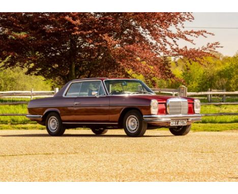
Lot 230
1973 Mercedes-Benz 250 CE (W114) Transmission: automaticMileage:93000Whilst the saloon versions of this model were somewhat sedate, the coupé's, with no b-pillar to interrupt the lines, was rather an elegant sight to behold. This design element came, unsurprisingly, from the pen of Paul Bracq world famous for a number of different Mercedes-Benz models as well as BMW gullwings, France's TGV and another a number of other significant cars the put him well and truly on the map. With the advent of this W114, he lowered the roof line and the seats to maintain the headroom. The windows wound down completely out of sight and the 2.5 litre; fuel-injected engine propelled this model effortlessly up to a perfectly respectable 115mph.Painted some two years ago in this stunning Bordeaux red with contrasting new black MB-Tex trim, the overall presentation is superb. It also benefits from new head rests and front armrest, not something that was originally specified when built. Something also to note is that it has benefits from electric windows front and rear, again not something that was standard at the time. Also included is a new sub-frame with new Bilstein shock absorbers all round as well as new discs and pads front and back. Also included is new sound proofing under the bonnet, A fully re-cored radiator and a light service and fresh 12 months MoT test certificate. I am advised that she drives extremely well indeed and the quality of the restoration all points towards a sound and well-presented example.Interested parties should note that due to engine damage in one of the bores, a fresh engine has been installed although the original.


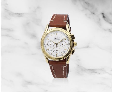
Lot 105
Zenith. Montre bracelet en or jaune 18K (750) avec date mouvement automatiqueZenith. An 18K gold automatic calendar chronograph wristwatchModel: El Primero Chronomètre '700 ans Confédération Helvétique'Reference: 30.0220 400Date: Purchased 7th January 1992Movement: 31-jewel Cal.400 automatic, No.86308Dial: White, applied alternating double and single gilt baton hour markers, black outer 1/5th second divisions, black outer tachymetre scale, subsidiary dials at 3, 6 and 9 for seconds, 30 minute and 12 hour recording, date aperture between 4 and 5, gilt polished baton hands, centre chronograph handCase: Polished tonneau form, snap on back, back engraved '700 ans Confédération Helvétique' with a map of Switzerland, No.104Strap/Bracelet: Brown leather Buckle/Clasp: Signed 18K gold buckleSigned: Case, dial & movementSize: 40mm Weight: 81,71g Accompaniments: COSC Certificate and Guarantee certificate dated 07/01/1992For further information on this lot please visit Bonhams.com


![I.L YoungGleneagles - A Map of The Golf Courses, signed.[37x75cm]](https://cdn.globalauctionplatform.com/af8fc866-e169-46df-b17b-b00700a04249/d39d7448-b5a2-4353-9bd7-b00700ed33e5/468x382.jpg)


Lot 4061
James Bond Skyfall (2012) - A prop door handle from the Skyfall Lodge. The twist effect handle with central bracket made from rubber to imitate iron. In the Film, the Skyfall House was perceived to be situated in Glencoe, however the House was actually purpose-built from scratch at Hankley Common in Surrey, whilst interior shots were filmed on a soundstage at Pinewood Studios. The full scale set was constructed from plywood & plaster which was destroyed in the Films explosive finale. Set in a framed display (18x11.5x2 inches) with a corresponding still. Provenance: Obtained from one of the Films Prop Masters. Accompanies a five page Location Prep & Map from Pinewood Studios dated 23rd January 2012, choreographing the Skyfall Lodge scenes.
Lot 742
A vintage lockable metal box along with small collection of vintage ephemera including a Geographia Footpaths map for Reigate area, an Ordnance Survey 1940 Second War Revision, Sheet 45, map of Buxton & Matlock published by the War Office in 1941, a 1943 illustrated souvenir of New York City, a souvenir booklet commemorating the crowning of King George VI and a part filled album of football skills cigarette cards.


![Ptolomaeus (Claudius) In hoc operae haec continentur Geographiae Cl. Ptolomaei..., without plates [text only], collation: A-C](https://cdn.globalauctionplatform.com/619f653b-98ff-4bdf-9ce7-aff900c462e6/f57857f6-e44f-4832-9494-aff900caaea7/468x382.jpg)
Lot 154
Ptolomaeus (Claudius) In hoc operae haec continentur Geographiae Cl. Ptolomaei..., without plates [text only], collation: A-C8, D-E6, F-O8, 2A-2B8, 2C4, lacking N1&2, title with large initial I and woodcut ?printer's device, woodcut initials, title with small hole (?abrasion; to blank section, but affecting woodcut initial to verso), A5 (silked repair) and O3 with closed tear affecting text but no loss, A8 paper repairs to blank inner margin, 1507, bound with Beneventanus (Marcus) Noua orbis descriptio..., collation: a,6b8, 1508, together 2 parts in 1, woodcut diagrams, some light marginal foxing, lower hinge broken, rear endpapers loose, later vellum, light wear to corners, folio (422 x 285mm.), Rome, for Bernardino Vitali and Evangelista Tosini. ⁂ Fourth Rome edition of Ptolemy's Geographia. In 1508 an updated version of this work was issued by the press, with a new title, and containing both Johannes Ruysch's famous 'Universalior cogniti orbis tabula...' map (not present in this copy), and a description of the New World by monk Marcus Beneventanus, making it the first edition of a Ptolemy to include an account of the New World. The copy here offered combines these two editions, presenting the 1507 text, with Beneventanus' account. Literature: I. Edit 16 CNCE 59093. II. c.f. Edit 16 CNCE 73332

Lot 188
Philippines.- Bellin (Jacques-Nicolas) Carte Réduite des Isles Philippines Pour servir aux Vaisseaux du Roy, large double-page map of the Philippines, with part of Borneo in the lower left corner, large decorative cartouche in the upper right, engraving with hand-colouring, on thick wove paper with watermark of double-headed eagle and text-based countermark, platemark 900 x 570 mm (35 1/2 x 22 1/2 in), sheet 930 x 650 mm (36 1/2 x 25 5/8 in), central horizontal fold with some minor splitting to edges, some handling creases, other marginal nicks and small repairs, unframed, Depot de la Marine, 1752

Lot 202
World.- Mercator (Rumold) Orbis terrae compendiosa description, double-hemisphere map of the world, a reduced version of Gerard Mercator's famous wall map of 1569, the borders decorated with strapwork, ornate compass rose and armillary sphere, engraving with full hand-colouring, platemark 285 x 520 mm (11 1/4 x 20 1/2 in), sheet 360 x 540 mm (14 1/4 x 21 1/4 in), Latin text verso, central vertical fold carefully reinforced verso, handling creases, repaired tear lower left corner, some toning, spotting and surface dirt, unframed, [circa 1587-1619]
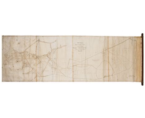
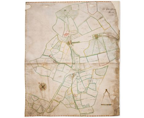
Lot 42
Wiltshire allotment maps.- Davis (John, Surveyor) and George Barnes. The Map of Allotments in the Tithing of East Downton; The Map of Alltoments in the Manor of Hampworth, two manuscript maps, the former with a large piece of land inscribed with owner's name 'Earl Nelson', pen and ink, some watercolour wash, both on joined sheets of wove paper, one with watermark date '1835', 540 x 1700 mm (21 1/4 x 66 3/4 in) and 520 x 870 mm (20 1/2 x 34 1/4 in), respectively, both with handling creases, browning and surface dirt, marginal nicks and tears, both affixed onto wooden rollers, [circa 1830s] (2)⁂ Allotment map with inscription denoting land presumably owned by Nelson's older brother, William Nelson, 2nd Baron Nelson (1757-1835) (created Earl Nelson in 1805).
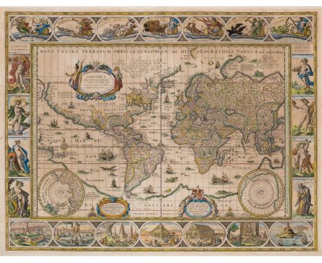
Lot 201
World.- Blaeu (Willem Janszoon) Nova totius terrarum orbis geographica ac hydrographica tabula, world map on Mercator's projection, with largely identical geographical information as found on Blaeu's wall map of 1605, elaborately decorated with ships, sea monsters, compass roses, and ornate border panels, the upper panel features allegorical representations of the sun, moon and the five known planets, the lower panel showing the seven wonders of the ancient world, with the elements and seasons featured in the left and right panels accordingly, engraving with early hand-colouring, a good impression of Shirley's fourth state (of five), on laid paper with indistinct watermark, platemark 410 x 545 mm (16 1/8 x 21 1/2 in), sheet 478 x 567 mm (18 1/2 x 22 1/4 in), Latin text verso, some light spotting and toning to sheet, minor surface dirt, unframed, Amsterdam, [circa 1635-58]Literature:Shirley 255 iv/v⁂ A masterpiece in world mapping from the Golden Age of Dutch Cartography.
Lot 198
Turkey.- Fellows (Charles) A Journal written during an excursion in Asia Minor ... 1838, first edition, etched frontispiece, double-page engraved map with route hand-coloured in outline, 20 plates, most lithographs, 1 double-page, wood-engraved illustrations, previous owner's pencil initials to title, cracked hinges, original cloth, gilt, bumping to corners and spine extremities, a little rubbed, [Atabey 424; Blackmer 578], large 8vo, 1839.⁂ An account of Fellows's first expedition to Lycia on the southern coast of Turkey, an area little known to Europeans at the time.
Lot 63
Blake (William).- Malkin (Benjamin Heath) A Father's Memoirs of his Child, first edition, engraved frontispiece by R. H. Cromek after William Blake and 3 plates, including one folding map, frontispiece laid down to sheet, one or two instances of finger soiling, contemporary red straight grain morocco, covers with rich gilt borders, rich dentelles, spine a little sunned, slight scratch to upper cover, minor scuffing to corners, 8vo, for Longman, Hurst, Rees and Orme by T. Bentley, 1806.⁂ Contains the first recorded account of Blake by a contemporary. Malkin knew Blake well, and herein devotes 24pp. in the preface to an account of his friend's life and genius, largely recorded from conversations with Blake himself. The preface also contains the first typographic printing of several of Blake's poems.
![Ordnance Survey.- [Ordnance Survey of England and Wales, on the Scale of One Inch to a Mile], 111 map sheets numbered 1 to 11](https://cdn.globalauctionplatform.com/619f653b-98ff-4bdf-9ce7-aff900c462e6/49550b4e-059d-43ee-854e-aff900ca04a3/468x382.jpg)
Lot 207
Ordnance Survey.- [Ordnance Survey of England and Wales, on the Scale of One Inch to a Mile], 111 map sheets numbered 1 to 110 as per the "original" numbering system, with 68 [NE Norfolk] in 2 parts, engravings, many with original hand-coloured county divisions, each sheet approx. 660 x 980 mm (26 x 38 1/2 in), dissected and mounted on linen, bearing the mapseller's red star label of J. Gardner, sole agent, on verso, minor occasional spotting and surface dirt, folding with green morocco gilt numbered thumb tabs, tab to sheet 100 missing, map sheets 97-110 appear to be from a [?]later edition without hand-colouring, all folding without slipcases, 4to, Colonels Mudge, Colby and others, The Tower, circa 1805-90; together with 4 variant summary publications on the Maps, Plans, and Other Publications of the Ordnance Survey, original paper wrappers, 1875, 1890, 1897, and 1903

Lot 186
Arabian Peninsula.- Anonymous (circa 1900) [Map locating the Qibla, looking towards Mecca from locations within the Arabian Peninsula and environs], lithographic map with text in Arabic, printed in brown ink on linen, mounted onto board, sheet 220 x 310 mm (8 5/8 x 12 1/4 in), some surface dirt and rubbing, corners of board bumped, [circa 1900].

Lot 190
Philippines.- Lowitz (George Maurice) Carte Hydrographique & Chorographique des Isles Philippines..., two-sheet version of Father Pedro Murillo Velarde's map of the Philippines, showing the route of the Acapulco-Manila galleon, and the track of Ferdinand Magellan, the first European to visit the islands in 1521, with large title cartouche in the upper right corner, compass rose and rhumb lines, engraving on laid paper with text-based watermarks, both sheets with uniform full original hand-colouring, each platemark approx.495 x 560 mm (19 1/2 x 22 in), each sheet 550 x 640 mm (21 3/4 x 25 1/4 in), central vertical folds, minor handling creases and old folds, manuscript ink numbering to upper right corners, unframed, Homann Heirs, 1760.⁂ The first reasonably obtainable large format map of the Philippines; a landmark in the history of Filipino cartography.
Lot 174
Holy Land.- Roberts (David) The Holy Land, Syria, Idumea, Arabia, Egypt & Nubia, 3 vol., first edition, ordinary format, lithograph portrait frontispiece, 3 tinted lithograph titles, 60 tinted lithograph plates and 60 half-page illustrations, engraved map, scattered foxing, worse on titles, vol. 3 with several leaves beginning to work loose, hinges strengthened, contemporary half-morocco, vol. 2 with backstrip becoming detached and small loss to extremities, rubbing to corners and joints, [Abbey Travel 385; Blackmer 1432], folio, 1842-49.⁂ "'The Holy Land' was issued in 20 parts in 3 formats: tinted lithographs in paper wrappers, proof plates in a portfolio and coloured lithographs mounted, in a portfolio. The vignettes (half-page) printed with letter-press in the ordinary format were printed as separate plates in the coloured and proof formats." (Blackmer)

Lot 196
Southeast Asia.- Laurie & Whittle (publishers) A New Chart of the Banda Sea, Including The Isles of Amboyna, and Banda, Those of Bouro, Ceram and The Circumjacent Islands, detailed chart with inset maps of the Bay of Amboyna and Islands of Banda, Goonong-Appee and Banda Neira, engraving on thick laid paper without watermark, sheet 470 x 630 mm (18 1/2 x 24 3/4 in), some off-setting and minor toning, old fold to lower edge with splitting repaired verso, unframed, 1799; together with 2 others of the region, including J. v.d. Bosch's 'Kaart der Bandasche Eilanden' from the Atlas der Overzeesche Bezittingen, and a lithographed map with the title 'Kaart van het Eiland Timor... 1847' by C.Franz, 360 x 520 mm (14 1/4 x 20 1/2 in) and 360 x 490 mm (14 1/4 x 19 1/4 in), respectively, unframed, 19th century (3)

Lot 179
Indonesia.- Java.- Chatelain (Henri Abraham) Carte de l'Ile de Java: Partie Occidentale, Partie Orientale. Dressee Tout Nouvellement sur les Memoires les Plus Exacts, large-scale chart of the island of Java, inset map in the lower left showing harbour and plan of Batavia, present day Jakarta, numerous text descriptions surrounding the map, engraving with fine early hand-colouring, on two sheets of laid paper conjoined, platemark 380 x 865 mm (15 x 34 in), sheet 445 x 1000 mm (17 1/2 x 39 1/2 in), old folds as issued, minor handling creases, some faint surface dirt and light toning, one or two small marginal nicks, unframed, 1719.
Lot 8
Middle East.- Howel (Thomas) A Journal of the Passage from India, by a Route partly unfrequented, through Mesopotamia, Armenia, and Natolia, or Asia Minor, first edition, large folding engraved map frontispiece with a few tears, final leaf with lower corner torn away, just touching the word "finis", occasional foxing, pencil annotations, uncut in original boards, worn, [Ghani p.181], 8vo, Printed for the author, [1789].⁂ Rare first edition of an account of Howel's year-long journey returning to England from India in 1787, up the Persian Gulf and the Euphrates and thence overland from Baghdad to Constantinople.
Lot 37
Wiltshire Estate Map.- Joliffe (Richard, Surveyor) A Mapp of Milkhills, Belonging to Robt. Eyre Esqr. of New-House, In the County of Wilts, manuscript estate map of land near Redlynch, title in the upper right quadrant, compass rose in the lower left corner, north oriented to the upper left, scale in the lower right corner, pen and ink, watercolour wash, numerous ink and pencil annotations, all within a green and white watercolour wash border, on vellum, 755 x 835 mm (29 3/4 x 32 3/4 in), some creasing, small marginal losses and pinholes, minor surface dirt and old damp-stains, mainly marginal, unframed, [circa 1730s]

Lot 206
British Isles.- Speed (John) [England Wales Scotland and Ireland Described and Abridged. With ye historic relation of things worthy memory from a farr larger voulume], lacking engraved title, 62 uncoloured engraved maps only (of 63), by Pieter Van den Keere, including one folding (British Isles), lacking Yorkshire, text leaf opposite folding map of British Isles with surface dirt and heavy restoration recto and verso, bound in the wrong way round, the folding map with browning and minor stains, the upper right corner with loss restored, some occasional surface dirt and minor browning, minor nicks, a few leaves with stains, later endpapers with owner inscription and red ink stamp of the poet John Drinkwater, dated 1917, modern calf, oblong 8vo, [George Humble, circa 1627-1631]

Lot 200
Vietnam.- Boucher (Lucien) France Indochine, decorative map of French Indochina, illustrated with vignettes of Angkor Wat, Pnom-Penh and Saigon, and numerous animals including elephants, lions, monkeys, and sea monsters, lithograph printed in colours, on wove paper, sheet 995 x 660 mm (39 1/4 x 26 in), mounted onto conservation support, some minor handling creases, unframed, éditée par l'Association nationale pour l'Indochine Française, [circa 1945-46]
Lot 39
Newhouse, Wiltshire Estate Map.- Joliffe (Richard, Surveyor), attributed to. A Plan of Newhouse Farme, very large manuscript estate map, title in the upper right quadrant, compass rose in the lower left corner, north oriented to the upper left, scale in the lower left corner, pen and ink, watercolour wash, numerous ink and pencil annotations, all within a red and yellow watercolour wash border, on two sheets of vellum conjoined, 1310 x 1070 mm (51 1/2 x 42 in), mounted on conservation support, some creasing, marginal losses and other losses carefully replaced in facsimile, some surface dirt and old damp-stains, mainly marginal, unframed, 1734⁂ Monumental estate map.
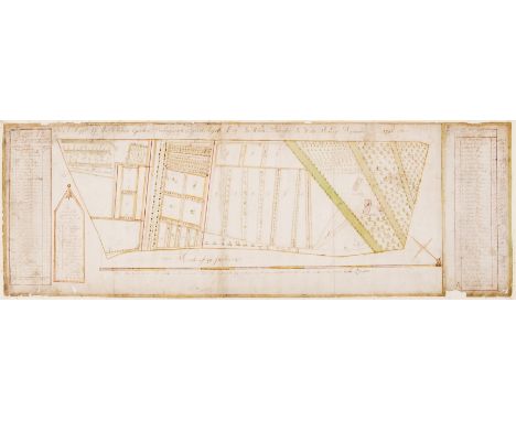
Lot 40
Lost Gardens of Newhouse.- Anonymous (English surveyor, active circa 1740s) A Mapp of the Kichen Gardens Belonging to Robert Eyre Esq. In White Parrish in Wilts. Survey'd September 1746, detailed map of the 18th century working kitchen gardens of Newhouse Estate, on 'a scale of 40 perches', with two columns to the left and right margins identifying details within the garden, mainly 'Fruit hedges', with a separate key identifying 'The Partes of the Garden and their names with the marks', which includes separate sections for asparagus, artichoke, raspberry, cherry, melon, and 'The bee garden', amongst others, pen and brown ink with watercolour, on three sheets of laid paper conjoined, total sheet 330 x 950 mm (13 x 37 1/2 in), mounted onto conservation paper support, some small losses, mainly to extremities, old handling creases, surface dirt, unframed, 1746Provenance:Newhouse Estate;Then by descent to the present owners ⁂ Rare 18th century record of a now lost garden, specifically the "Kichen" garden of Newhouse, Wiltshire. Executed by an unrecorded surveyor on behalf of Robert Eyre (c.1693-1752), the eldest son of Sir Robert Eyre, MP, of Newhouse, and his wife Elizabeth Rudge, daughter of Edward Rudge of Warley, Essex.
Lot 176
India.- Crawfurd (John) Journal of an Embassy from the Governor-General of India to the Court of Ava, in the Year 1827... With an Appendix, Containing the Description of Fossil Remains, by Professor Buckland and Mr. Clift, first edition, half-title, 5 aquatint plates, of which 3 hand-coloured, 5 lithographed plates, folding engraved map (light off-setting, and small hole at fold), folding engraved plan, wood-engraved illustrations, some light foxing to plates, map and plan, original boards with paper label to spine, lower joint broken with upper cover and back-strip (together) detached, small chips to label and spine ends, [Abbey Travel 405], 4to, Henry Colburn, 1829.
Lot 38
Newhouse, Wiltshire Estate Map.- Joliffe (Richard, Surveyor) A Map of Newhouse Farme &c., In Com. Wilts., manuscript estate map of Newhouse and its environs, title in the upper right quadrant, compass rose in the lower left quadrant, north oriented to the upper left, scale in the lower right corner, pen and ink, watercolour wash, numerous ink and pencil annotations, on vellum, 1150 x 900 mm (51 1/2 x 42 in), mounted on linen, remnants of green silk edging, heavy creasing, surface dirt, spotting, and old damp-stains, unframed, 1731
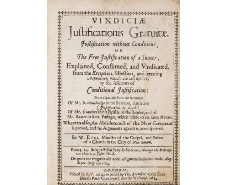
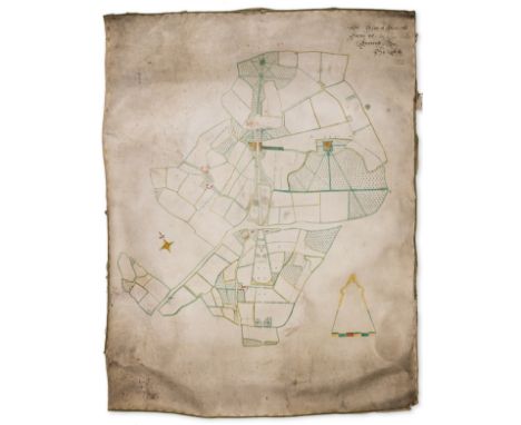
Lot 1
Eyre (William) Vindiciae Justificationis Gratuitae. Justification without Conditions; of The Free Justification of a Sinner, Explained, Confirmed, and Vindicated, Reader note opposite title, title within typographical border, letter loosely inserted sending the vol. to Matcham, slightly browned, a few ff. with slight staining in margins, a few brown marks, front free endpaper corner torn away, contemporary calf, scratched, edges rubbed, lacks head and tail of spine, [Wing E3947], for R. I. and... Tho. Brewster, 1654 § Leigh (Edward) The History of the Twelve Caesars, p. 109 to end slight worming in upper margin, slightly browned, contemporary calf-backed boards, rubbed, lower cover detaching, Paisley, J. Weir, 1791 § Jackson (Rev. J.E.) Wulfhall and the Seymours, presentation copy from the author to George Matcham, frontispiece and map, manuscript inscription on title "Privately Printed", original morocco-backed boards, 1874; and c. 17 others from the Matcham Library, v.s., v.d. (c. 20).

Lot 507
A quantity of decorative contemporary ceramics to include an art potter jug with potters seal impressed mark; various Poole pottery items to include Poole map plate; a modern print of a still life of a chair; a Victorian vase; glass bowl; a pair of cream glazed pottery wall brackets; etc (qty)All in generally good condition. The Victorian vase with wear to the gilding.


-
109182 item(s)/page