Antikbar Original Vintage Posters
Lot 277
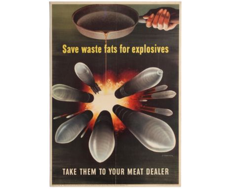
Original vintage WWII US propaganda poster published by the U.S. Government Printing Office for the home front: Save waste fats for explosives - Take them to your meat dealer. Save Waste Fats for Explosives by Henry Koerner, 1943, for the Office of War Information Artist: H. Koerner Period: Second World War A hand coming from the upper right corner pours fat from a frying pan into an explosion at the centre of the poster. From the explosion thirteen assorted shells speed outwards, towards the viewer. On the home front during World War II, posters urged women to conserve precious resources for the war effort, whether that was by breeding rabbits for their meat or collecting cooking fats for conversion to glycerin, an ingredient in explosives. An article in The Nevada Daily Mail from October 30, 1942, explained "Every drop of waste kitchen fat is needed to make the high explosives necessary to blast Hitler & Co. off the map. And glycerine makes explosives for the U.S. and our allies. So, save all your waste fats after you've got the good from them." Henry Koerner (born Heinrich Sieghart Körner; August 28, 1915 – July 4, 1991) was an Austrian-born American painter and graphic designer best known for his early Magical Realist works of the late 1940s and his portrait covers for Time magazine. Born in the Leopoldstadt District of Vienna to non-observant Jewish parents Leo Körner (1879–1942) and Feige ("Fanny") Dwora Körner née Mager (1887–1942), Koerner attended the Realgymnasium Vereinsgasse. Trained in graphic design at Vienna's Graphische Lehr- und Versuchsanstalt (1934–36), he worked in the studio of Viktor Theodor Slama, designing posters and book jackets. Following Hitler's annexation of Austria in 1938, he fled via Italy (Milan and Venice) to the United States, settling in New York and in 1940 marrying Viennese-born Fritzi Apfel. Employed as a commercial artist in Maxwell Bauer Studios in Manhattan, he achieved initial success as a poster artist, receiving first prize from the American Society of the Control of Cancer Poster Competition and two first prizes from the National War Poster Competition. In 1943, the Office of War Information hired Koerner in its Graphics Division in New York, where he worked alongside artists Ben Shahn, Bernard Perlin, and David Stone Martin. Shahn's pictorial style, along with the photography of Walker Evans and German Neue Sachlichkeit painters (e.g., Otto Dix), inspired Koerner's painting, which began with a rendering of his family home in Vienna (My Parents I, 1944). That first painting is the subject of the film "The Burning Child". Drafted into the U.S. Army, he was ordered in 1944 to the Graphics Division of the Office of Strategic Services in Washington, D.C. where he made war posters, including Save Waste Fats and Someone Talked, the latter winning an award from the Museum of Modern Art. Shipped to London, he documented, in pen and ink sketches and photographs, everyday life during wartime. After VE Day (8 May 1945), Koerner was reassigned to Germany, working in Wiesbaden and Berlin, and sketching defendants at the Nuremberg trials. Good condition, folded as issued, restored folds, backed on board. Country: USA, year of printing: 1943, designer: H. Koerner, size (cm): 57.5x41


![[Munster, Sebastian] pp.1265-1280 from a French edition of his Cosmographia, 12 woodcut illus, including a pictorial map, 20t](https://cdn.globalauctionplatform.com/0e8df5aa-1f01-4d17-89f4-ab4300a5015b/6b5ba221-3d1d-4be1-9705-ab4b01018be0/468x382.jpg)


![[Cromwell, Thomas Kitson] - Excursions in the County of Norfolk, 2 vols, 8vo, half calf, folding map and 2 engraved titles an](https://cdn.globalauctionplatform.com/0e8df5aa-1f01-4d17-89f4-ab4300a5015b/aa2ff304-69ff-45b6-a522-ab4b01079469/468x382.jpg)


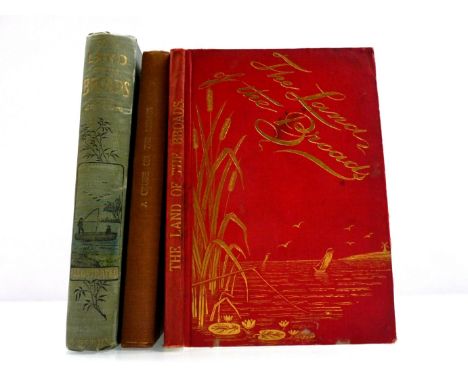
![George Christopher Davies, 3 titles: 'The Swan and Her Crew', [1876], 1st edition, frontis + 6 full page and numerous in text](https://cdn.globalauctionplatform.com/26b79d93-27e2-46fa-ad45-ab3a00b18d36/18f16ff6-edef-46ac-a13a-ab4400d90857/468x382.jpg)


![[Count D'Epremesiul]: 'En Wherry - Trois semaines dans les Broads du Norfolk', Paris, 1892, 1st edition, 5 photogravure plate](https://cdn.globalauctionplatform.com/26b79d93-27e2-46fa-ad45-ab3a00b18d36/acf32c90-1674-4e63-aeb0-ab4400d90b71/468x382.jpg)
![[Edward Empson Middleton]: 'The Cruise of The Kate. A Narrative of a Very Merry Wherry Expedition Through the Rivers and Broa](https://cdn.globalauctionplatform.com/26b79d93-27e2-46fa-ad45-ab3a00b18d36/13d59926-4eb1-40e6-a09a-ab4400d90d16/468x382.jpg)

![Ernest Suffling, 4 titles: ' 'How to Organize a Cruise on the Broads', [1891], 1st edition, folding map, [4]pp adverts at en](https://cdn.globalauctionplatform.com/26b79d93-27e2-46fa-ad45-ab3a00b18d36/d7606ba7-3438-4374-98f2-ab4400d91381/468x382.jpg)
![[Count D'Epremesiul]: 'En Wherry - Trois semaines dans les Broads du Norfolk', Paris, 1892, 1st edition, signed and inscribed](https://cdn.globalauctionplatform.com/26b79d93-27e2-46fa-ad45-ab3a00b18d36/d08de553-e739-468d-8004-ab4400d9143f/468x382.jpg)
![[Count D'Epremesiul]: 'En Wherry - Trois semaines dans les Broads du Norfolk', Paris, 1892, 1st edition, 5 photogravure plate](https://cdn.globalauctionplatform.com/26b79d93-27e2-46fa-ad45-ab3a00b18d36/3b05bcc2-5c55-445f-9a1c-ab4400d91520/468x382.jpg)
![[Charles Coleman Laing] : A Week on The Bure, Ant, and Thurne', 1895 “privately printed”, limited edition, 4 plates plus map](https://cdn.globalauctionplatform.com/26b79d93-27e2-46fa-ad45-ab3a00b18d36/71ac9426-e792-44b6-9b74-ab4400d9159d/468x382.jpg)
