We found 109198 price guide item(s) matching your search
There are 109198 lots that match your search criteria. Subscribe now to get instant access to the full price guide service.
Click here to subscribe- List
- Grid
-
109198 item(s)/page


Lot 415
A 'Playground' London Tube map poster by Maindustrialdesign.com, MA Industrial Design 2009, unframed, 84 x 119cm, together with an exhibition poster for 'Paradise of Exiles - North European Artists in Italy 1600-1880' at the Fitzwilliam Museum, October 1990, 69 x 49cm, three Andy Warhol Marilyn Monroe reproduction posters, 84 x 60cm, and five Body Pressure posters (10)


Lot 515
A Selection of booklets to include The History of New Zealand in picture Map and Story (Published by NABISCO PTY LTD) A Booklet with artists impressions of the city, entitled Rothenburg 0.T.. A rare hand painted cartoon entitled The Lord is my Shepherd I Shall not want, (Published by The CYNICUS Publishing)


Lot 495
A Collection Of Military Ephemera To Include : A Liberation Of Norway Certificate, Norwegian Lament, Map Of Norway, Norwegian Flag And Photographs, Devizes War Memorial Order Of Service 1921, A Collection Of Military Release Documents, Various Items Of Ephemera Relating To Palestine To Include Photogrpahs. To Also Include A Small Selection Of Badges To Include Wiltshire Regiment And Home Guard.


Lot 383
A John Speed, 17th Century Map of Poland, Speed, John (1552-1629). 17th-Century map of Poland, hand-coloured copper engraving, featuring inset city views and figures displaying regional fashions/costumes, published by Bassett & Chiswell, English text to verso. mounted on card with three small pieces of tape (both sides visible). 41cm x 52cm

Lot 384
A Late 18th Century Map of The European Part of the Russian Empire, late 18th Century map of "The European Part of the Russian Empire, The Asiatic Part of the Russian Empire", publ Robert Sayer, London 1st May 1790; engraved map with hand-colouring, from the maps published by the Imperial Academy of St Petersburg with the new discoveries of Capt Cook & co, 49x129.5cm

Lot 385
A Late 18th Century Map of The European Part of the Russian Empire, late 18th Century map of "The European Part of the Russian Empire, The Asiatic Part of the Russian Empire", publ Robert Sayer, London 1st May 1790; engraved map with hand-colouring, from the maps published by the Imperial Academy of St Petersburg with the new discoveries of Capt Cook & co, 49x129.5cm

Lot 387
An Early 17th Century Panorama of Lowicz, Poland, Georg Braun (1541-1622) Franz Hogenberg (1535-1590), 'Lovicensis Civitas quae est Archiepiscopa', copperplate panorama of Lowicz with the marking of the most important buildings showing the city performing the role of the residence of Gniezno archbishops of Poland, the map comes from the work "Civitas Orbis Terrarum", Cologne, 1618, verso with latindescription, 32.5 x 49 cm

Lot 388
An Early 17th Century Panorama of Lowicz, Poland, Georg Braun (1541-1622) Franz Hogenberg (1535-1590), 'Lovicensis Civitas quae est Archiepiscopa', copperplate panorama of Lowicz with the marking of the most important buildings showing the city performing the role of the residence of Gniezno archbishops of Poland, the map comes from the work "Civitas Orbis Terrarum", Cologne, 1618, verso with latin description, 32.5 x 49 cm


Lot 393
A 16th Century Woodcut Map of Poland, Lithuania, the Ukraine, Moscovy and the Balkans, Munster, c.1540, Woodcut map titled 'Polonia et Ungaria XV Nova Tabula', showing Poland, Lithuania, the Ukraine, Moscovy and the Balkans, extending from Prussia, Vilna and Smolensky in the north to Bosnia, Bulgaria, Constantinople and the Crimea in the south, centered on Poland, text to versoNote: this is the earliest obtainable modern map of this region, first issued in 1540, the only difference between this map and the first state is a small printer's device in the title.
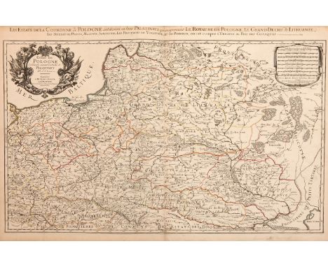
Lot 394
A Large Scale 17th Century Map of Poland and Surrounding Countries, SANSON, N and JAILLOT, A.H., Paris 1685, titled 'Les Estates de Couronnede de Pologne en leurs Palatinatsqui comprennet Le Royaume de Pologne, Le Grande Duche de Lithuanie', Large scale map of Poland and Lithuania, including the surrounding bordering regions of Hungary, Austria and Russia, detailing rivers, lakes, forest, mountains, major cities and towns, with a decorative title cartouchee in the top left corner, and a cartouchee with a distance key in top right corner


Lot 396
A 17th Century Map of Zamosc in Poland, Braun & Hogenberg, C.1618, titled 'Zamoscium. Nova Poloniae civitas, à magnifico eius regni Cancellaro à fundamentis exstructa', unusual birds-eye view of the walled city, with cartouchee to top left with names for the buildings.Note: taken from 'Theatri praecipuarum Totius Mundi Urbium Liber Sextus'

Lot 397
Two Early Maps of Poland, Matthaus Quad, Printed in Cologne, c.1592, detailed map of Southern Poland and the from the Weysel River in the north to the Carpathian Mountains in the south, centered on Auschwitz,Nicholas de Fer, Paris 1705, Birds eye view of Kamieniec, key to buildings and explanation in both corners, dimensions 35cm x 26cm
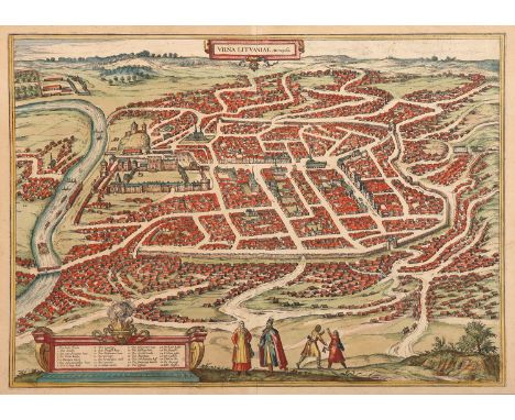
Lot 400
A 16th Century Map of Vilnius, Lithuania, Braun & Hogenberg, 1599, map title 'VILNA LITVANIAE' hand coloured, 53cm x 42cmNote: from first latin edition of Volume III, plate 59, of "Civitates orbis terrarum," drawn 1576, possibly based on an image by the Flemishartist, Guillebert de Lannoy, who visited Vilna in 1414

Lot 404
An 18th Century Map of the Polish Empire, Extending South to the Black Sea, Henri Abraham Chatelain (1684-1743), Paris 1712, title reads 'Carte De Pologne Avec La Chronologie Des Rois Et Des Ducs De Lithuanie, Ainsi Que Des Grands Maitres De L'Ordre Teutonique Les Evechez et Archeveches, et Les Armes Des Provinces...', copperplate engraving original uncoloured, including 30 coats of arms and key to map locations, French text, dimensions 64cm x 56cmNote: from 'Atlas Historique', published in seven volumes between 1705 and 1720

Lot 405
A 17th Century Map of Poland, lithuania, Ukraine, Prussia, Johannes de Ram, c.1690, titled 'Regni Poloniae et Ducatus Lithuaniae Volhyniae, Podoliae, Ucraniae, Livoniae et Curlandiae, Descriptio, Ementata de Johannes de Ram', Copperplate engraving original uncoloured, cartouche in bottom left corner showing traders with a camel and a monkey, cartouche to right showing key to symbols, dimensions 58cm x 50cm.Note: we have been unable to find this map in this form with these 3 cartouche designs
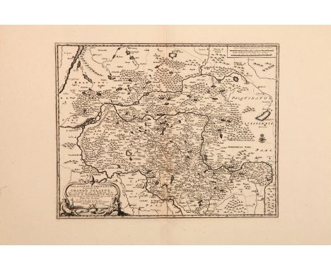
Lot 407
An 18th Century Map of Poland & Prussia, Pieter van der Aa (1659-1733), published Leiden, C.1715, cartouche to bottom left corner reads 'Palatinat de Posnanie, la premier de la Grande Pologne, Avec une partie de celui de Kalisch, et les Frontieres du Brandebourg et de Silesie…' copper engraved, Dimensions, paper 64cm x 54cm, image 35.5cm x 28cmNote: from 'Nouvel Atlas, très exact et fort commode pour toutes sortes de personnes, Contenant Les Principales cartes géographiques' Leiden, P. Van der Aa

Lot 408
A Late 17th Century Map of Poland, Prussia, Lithuania and Ukraine, Nicolaas Visscher after N. Sanson, c.1690, decorative cartouche showing two wind heads, a cheetah’s head and two sets of bows and arrows reads 'abula nova totius Regni Poloniae in quo sunt Ducatus et Provinciae Prussia, Cujavia, Mazovia, Russia, Nigra &c. Ducatus Lithuania, Ukrania…, copper engraving hand coloured, dimensions 64cm x 53cm


Lot 411
One of the Earliest Printed Maps of Ukraine, Moses Pitt, c.1680, cartouchee reads 'Typus Generalis Ukrainae sive Palatinatuum Podoliae, Kioviensis...', coper engraving, uncoloured, 58cm x 47cm.'Note: Pitt's map, first issued by Jan Jansson in about 1657, is one of the earliest maps to include the name Ukraine in the title of a printed map, following shortly after the Treaty of Zboriv in 1649

Lot 412
An 18th Century Map of Poland, Guillaume De L'Isle, published paris, c.1702, with cartouche which reads 'La Pologne Dressee sur ce qu'en ont donne Starovolsk, Beauplan, Hartnoch . . .', copper engraving, uncoloured, verso plane, dimensions 71cm x 53.5cmNote: Rare first edition of De L'Isle's map of Poland, one of the most influential maps of Poland published at the beginning of the 16th Century by perhaps the most important map maker of the period.

Lot 413
An 18th Century Detailed map of the Polish Empire, published by John Senex, John Senex, Published London, c.1719, cartouche reads 'Poland and other the Countries belonging to the Crowne According to the Newest Observation 1719'Note: This, the second edition of the map, which had been published by Morden & Browne in 1710 shows the remnants of the earlier printing, which have been burnished out of the cartouche.


Lot 141
NO RESERVE Sci-Fi & Fantasy.- Star Wars Interest.- Asimov (Isaac) More Tales of the Black Widowers, 1977; Fantastic Voyage II: Destination Brain, 1987 § Wolverton (Dave) Star Wars: The Courtship of Princess Leia, 1994 § Tolkien (J.R.R.) The Hobbit, double-page map, colour frontispiece & plates, ownership inscription to map reverse, 1976, last first deluxe edition, others first editions, original cloth, last upper board stamped in gilt, silver, and red with dragon motif, all but last spine ends a little bumped, last original presentation box, paper label printed in red and black to lid, a little rubbed and soiled, others dust-jackets, first and third with very minor creasing at spine head, third spine a little faded; and 16 others, 8vo & 4to (20) ⁂The last with inscription: "For | Daniel | Anthony Daniels c.3PO".
-
109198 item(s)/page