We found 109198 price guide item(s) matching your search
There are 109198 lots that match your search criteria. Subscribe now to get instant access to the full price guide service.
Click here to subscribe- List
- Grid
-
109198 item(s)/page


Lot 386
I SCHAPERA "The Bantu-Speaking Tribes of South Africa, An Ethnographical Survey" 1st edn., 1937, published by George Routledge & Sons, Ltd., London/Maskew Miller, Ltd., Cape Town, inc. folding maps; and one other, Hollis "The Masai, Their Language and Folklore", 1905, lacks map and one plate, (2).


Lot 14
General - British Commonwealth : KGVI fine mint collection in an S.G. Philatelic album (smaller format), Aden through to Zanzibar, note Aden Hadhramaut 1942-46 set, Bahamas 1938 to 5s, Br. Guiana 1938 to $3, Br. Somaliland 1938 set, Solomon Is 1939 to 10s, Cyprus 1938 to £1, Falkland Dependencies 1944 opts complete, Map pairs with broken arcs, Grenada to 10s (2 diff), India 1940 set, Leewards to 5s, Nigeria 2s.6d and 5s perf 13 x 11½, Nyasaland 1945 set, St Helena 1938 incl. 1d and 3d, St. Kitts to 5s, St. Lucia 1938 to £1, Seychelles 1938 incl. better colours to 1r green, others to 5r, South and S.W.A. incl. better War Efforts, and much else, very fresh and stated to cat over £5000. (approx 780 stamps). HEAVY LOT - OVERSEAS BIDDERS PLEASE ENQUIRE FOR SHIPPING COSTS

Lot 49
Spain.- Wit (Frederik de) Andaluzia continens Sevillam et Cordubam, southern Spain from the border of Portugal to Almeria, engraved map with hand-colouring, 355 x 500 mm., full margins, blank verso, central vertical fold with repaired splitting, minor nicks and tears, light spotting and browning, [Amsterdam], [circa 1682].
![Staffordshire.- [Plot (Robert) The Natural History of Stafford-shire], first edition, lacking all before a1 (engraved title &](https://cdn.globalauctionplatform.com/6bc7eec9-6cda-49a3-91ef-a8b7012366be/685b39f0-b718-48ad-c2fd-158cc01a8332/468x382.jpg)
Lot 55
Staffordshire.- [Plot (Robert) The Natural History of Stafford-shire], first edition, lacking all before a1 (engraved title & 'Copy of the Proposals' leaf), map and final 2 leaves (list of subscribers) but with the rare 'Armes Omitted' plate and 4pp. 'Directions for a right understanding of the Map' (both often missing) plus the 37 engraved plates by Burghers, most double-page and/or folding, several with tears to fold, plate V frayed with slight loss to one corner, plates XXVIII & XXXIV defective at left-hand edge, a little soiled and stained, hole to b1 (signed b2) with loss to 4 lines of text, contemporary panelled calf, rubbed, rebacked preserving most of old spine, corners repaired, [Wing P2588], folio, Oxford, At the Theatre, 1686; sold not subject to return⁂ With two chapters on minerals and stones, including fossils; by the first keeper of the Ashmolean Museum.
![Ireland.- [Leap Castle]. Archive relating to the Darby family of Leap Castle, Co. Offaly, including: (1). 2 manuscript maps (](https://cdn.globalauctionplatform.com/6bc7eec9-6cda-49a3-91ef-a8b7012366be/92c8a573-fb45-4cab-ea84-25e3fdd0af29/468x382.jpg)
Lot 83
Ireland.- [Leap Castle]. Archive relating to the Darby family of Leap Castle, Co. Offaly, including: (1). 2 manuscript maps (manuscript map of of the parish of Aghacon in the Barony of Ballybritt in King's County, showing Leap Castle, 300 x 240mm., [c. 1740]; manuscript map, partly hand-coloured, of Roscone in the Barony of Ballybritt, 300 x 180mm., 1826 (2). 13 Autograph Letters signed from various correspondents in Ireland to John Darby in Leap and London, together 18pp., 1802-06, rental matters etc. (3). Autograph Letter signed from John Darby to his son Horatio, 3pp., 1833, dealing with land issues, the destruction by fire at Leap of old documents demonstrating the family's right to a bog etc., and other material, folds, browned, v.s., v.d., 1693-1833; and c. 65 letters from Thomas Bateson, brother of Robert Bateson-Harvey, first Baronet of Killoquin, Co. Antrim, on Irish matters, 1777-93, v.s., v.d. (qty).

Lot 698
SOCIAL HISTORY, photographs (185*) depicting the tour to Malaya 1956-1958 of RAF 194 Squadron, inc. natives, Chinese New Year Festival, Fort Sinderette, Batu Caves, Sin Gun at Sunget Shepet, Singapore, helicopter crash, Port Dickson, Temples, Buddhas, Blakang Mati, Chinese School, Rubber Plantation, etc., corner-mounted in period wooden table top album decorated with map of Malaya (cover detached), compartment to left edge for pens etc with cover missing, o/w G to VG

![Antiquarian Book - Virtue's Picturesque Beauties of Great Britain: Kent [...] in a Series of View, By the Most Approved Artis](https://cdn.globalauctionplatform.com/a5a4bc81-0d41-475f-8855-a8b800909396/8f9cc26e-de42-461e-cf4f-d6f5cd9d6cc5/468x382.jpg)
Lot 1313
Antiquarian Book - Virtue's Picturesque Beauties of Great Britain: Kent [...] in a Series of View, By the Most Approved Artists, Taken expressly for this Work, By Messr. G. Shepherd, H. Gatineau [...], Comprising the Principal Cities & Towns, Public Edifices & Dock Yards; Seats of the Nobility and Gentry; Hospitals, Churches, Castellated & Monastic Ruins, &c., Accompanied by Historical & Biographical Notices, Published by G. Virtue, London [1829], 130pp, [ii], pull-out six-fold copperplate engraved map of the county bound between half and full-title page, contemporary gilt-embossed calf, marbled endpapers, square 4to


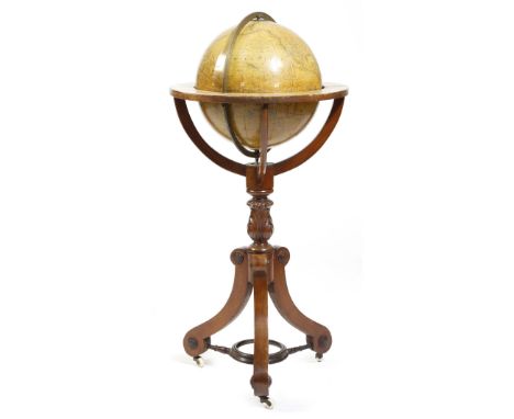
Lot 41
A Victorian terrestrial library globe by Cruchley, of twelve gores, 30.5cm diameter, inscribed 'CRUCHLEY'S NEW TERRESTRIAL GLOBE From the most recent Authorities EXHIBITING THE DISCOVERIES IN EQUATORIAL AFRICA, NORTH POLE, And the new Settlements & Divisions of AUSTRALIA, NEW ZEALAND, CALIFORNIA, TEXAS & c. LONDON G. F. CRUCHLEY MAP SELLER, GLOBE MAKER & PUBLISHER, 81 FLEET STREET', dated '1869', on a carved mahogany stand, with scroll legs united by an undertier, inset with a compass, on ceramic castors, 92.5cm high. Provenance: The collection of the late Geoffrey Harley, Pickwick End, Corsham.Click here to view the online page turning catalogue.
![[John Adolphus] Voyages and Travels of Her Majesty Caroline Queen of Great Britain including Visits to Various Parts of Germa](https://cdn.globalauctionplatform.com/f6159b7e-0473-4c86-954a-a8af00976897/5a23fd38-fcd8-4149-836d-9efb9c8b1ecd/468x382.jpg)
Lot 550
[John Adolphus] Voyages and Travels of Her Majesty Caroline Queen of Great Britain including Visits to Various Parts of Germany France Italy Greece Palestine etc the whole embellished with Picturesque Views published by Jones & Co 1821, engraved plates and folding map, half leather, marbled boards with gilt lettered label

Lot 575
The Natural History of Lancashire, Cheshire And The Peak in Derbyshire with an Account of the British Phoenician, Armenian, Gr and Rom. Antiquities in Those Parts by Charles Leigh, printed for the author 1700, issued in 3 books bound in one containing a number of engraved plates and with a double-page hand coloured map, folio volume in leather boards with raised bands (detached)


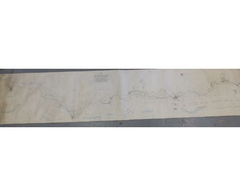
Lot 712
Thomas Rhodes map of the River Severn from Gloucester to Worcester extending from Near the Lower Parting in the County of Gloucester to Gladder or Whitehouse Brook within the Parish of Arley Kings in the County of Worcester, drawn for the Severn Navigation Company. The survey was engraved in London on 8 sheets by John Gardner and extends to a total length of nearly 5 metres, enhanced by a delicate wash colour. Scale 4inches to 1 mile. Published in 1837.


-
109198 item(s)/page