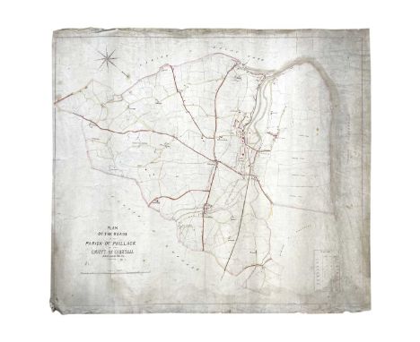
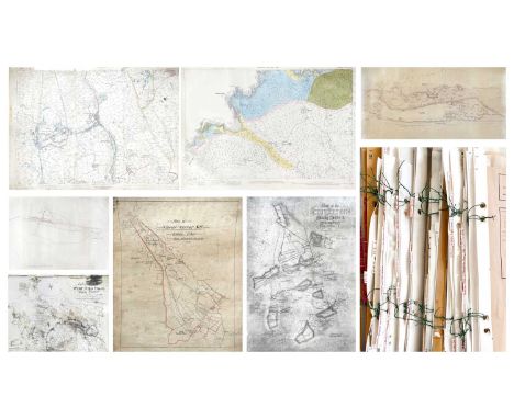
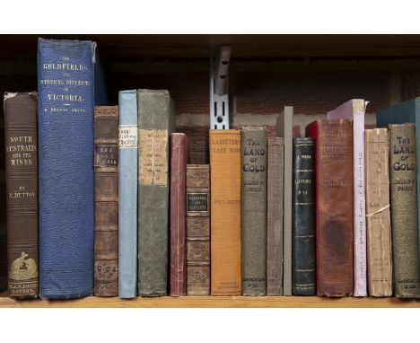
(Mining interest). A comprehensive study of geology and mining within Cornwall Mine Surveys, OS maps, facsimile prints of historic plans &c. &c, by Martin Mount, former geologist to Geevor Mine. An extremely large collection consisting of large Second Edition OS maps with annotations, copies of historic plans and acetate transparencies, mostly good to very good, with the larger works suffering nibbles and loss, the whole collection indexed and kept in order, with examples listed as follows;Cornwall Sheet LXXIII.1, Cape Cornwall, Second Edition 1908, detailed survey with copious hand annotations showing mines and loads &c; With printed transparency LXXIII.1, Cape Cornwall; With seventy four mostly second edition Ordnance Survey maps, covering West Cornwall, appox 76x 106cm, mostly vg, indexed and kept in order;OS maps of St Austell China Clay area, coloured with annotations by Pearce, Jenkin & Bawden of Redruth (amongst others), with a large number of unannotated OS maps, strictly of Cornwall and acetate transparencies, approx 50 +;Acetate transparency of Cornwall Sheet LXXIII:5, showing copious mine lode's for St. Just Amalgamated, WH Cunning, Goldens, and Bellan mines; Facsimile printed 'A Geological Map of Saint Just Mining District, Cornwall, 1867; 'Bocaswell United Tin & Copper Mines, Limited. Sketch Plan of Properties,' printed map with colour key, folded with repairs, no date but thought to be early 20th century; Acetate transparency of Cornwall Sheet LXXIII.2, showing copious mine lode's for Botallck Mine, Carnyorth Mine, Wheal Boys and Spearn Consols;Large collection (approx 50+) of mostly second edition OS maps, some with hand colouring, all areas within Cornwall, including, Lanivet, Pydar, Tawna Moor, Luxulian, Roche, Withiel, Bodmin Moor, Colliford Downs, Porquin Bay, &c.&c. indexed and in order;Acetate transparency showing lodes for Geevor Mine, North Levant Mine, Spearn Consols, Boscaswell Downs MineWheal Hearle &c, &c; Acetate transparency of Cornwall Sheet LXVII showing Morvah Consols, Morcah Unted and Zennor Mines; With five other acetates and their paper counterparts;'Plan of the Sett Belonging to Wheal Darby Mine....1841,' facsimile print; 'Map of the St. Agnes Mining District, Cornwall. 1870,' facsimile print, staining to bottom; 'Clowance Wood, Mining District, 1863,' facsimile print; 'Plan of Cosgarne Downs,' facsimile print; 'Polstain and Bosore in the parish of Kenwyn,' facsimile print; 'A Geological and Mining Map of the Parish of Gwennap....1845,' facsimile print; With acetate transparencies and paper counterparts;'Plan of the Town of Redruth in Cornwall, 1855,' facsimile print on 17 large sheets;Facsimile prints including, 'Map of the Chiverton Mining District, Perranzabuloe'; 'Geological Map of the Mining District of Cornwall, Between Camborne and Chasewater....1819'; 'Wheal Wentworth in the Parish of Redruth,' surveyed by R Thomas, Falmouth, 1825; 'Map of Towan Mines in Cornwall'; 'Penden-an-Drea and Wheal Sparnon Mine Sett in the Parishes of Redruth and Gwennap,' with a corresponding traced overlay showing adits and lodes; With numerous other facsimile prints.Facsimile prints including 'A Mineralogical Plan of the Manor of Treveneague and Penberthy....1791; 'Plan of Part of the Manor of Treveneague and Lands adjoining: Situate in the Parish of St Hilary, Cornwall'; Geological Mao of the Great Huel Vor...1863'; 'Plan of Treskerby, Wheal Busy, & Tolgus Mining District'; 'Map of Camborne, Illogan, Redruth & Gwennap Mines' by Robert Symons & Son, Mineral Surveyours, Truro'; &c. &c.With many more, too many to list.


![[Anon.]: 'To Gibraltar and Back in an Eighteen-Tonner, by One of the Crew', London, W.H. Allen, 1888, 1st edition, inscribed](https://cdn.globalauctionplatform.com/735ed8a4-87b1-4085-8a7b-b16f00f35a4a/e4ea59c7-734d-45d6-bf5c-b17000fe3482/468x382.jpg)
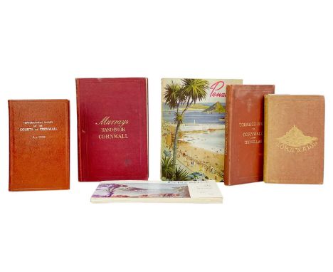
![(Cornwall) Thirteen works [REDDING, Cyrus]. 'An Illustrated Itinerary of the County of Cornwall,' half leather rubbed and bum](https://cdn.globalauctionplatform.com/a081397c-a086-4b4b-920a-b13000f00267/1f2769cf-85a3-442b-951c-b16c00f44722/468x382.jpg)