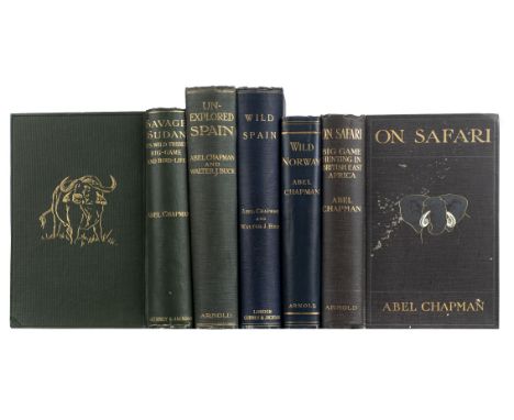

Chapman (Abel). On Safari. Big-Game Hunting in British East Africa, with Studies in Bird-Life, 1st edition, London: Edward Arnold, 1908, 2 photogravure plates including frontispiece, 32 halftone plates, 4 + 16 pp. advertisements, duplicate of plate at p.108 ('Jackson's Hartebeests') laid in, light spotting to frontispiece, a few leaves unopened, fore and bottom edges untrimmed, original pictorial cloth gilt, mottling and small perforation to front board, 8vo together with: Savage Sudan, its Wild Tribes, Big-Game and Bird-Life, 1st edition, London: Gurney and Jackson, 1921, 30 plates including frontispiece, top edge gilt, others untrimmed, original pictorial cloth gilt, 8vo, Wild Spain (España Agreste). Records of Sport with Rifle, Rod, and Gun, Natural History and Exploration, 1st edition, London: Gurney and Jackson, 1893, folding map frontispiece, 51 halftone plates, 4 pp. advertisements, frontispiece spotted, edges untrimmed, original cloth, spine slightly rolled, large 8vo, Wild Norway: with Chapters on Spitsbergen, Denmark, etc., 1st edition, London: Edward Arnold, 1897, 16 halftone plates, 2 + 16 pp. advertisements, original cloth, 8vo, Unexplored Spain, 1st edition, London: Edward Arnold, 1910, 32 halftone plates, 22 pp. advertisements, original pictorial cloth gilt, wear to upper inner corner of front board, lower outer corners bumped, 4to (Qty: 5)NOTESTHE DAVID WILSON LIBRARY OF NATURAL HISTORY PART I Provenance (Wild Norway): Presentation copy, inscribed by the author 'To Howard Saunders Esq. with the author's sincere thanks - gratias non semel, sed terque, quaterque curatus' on the front free endpaper. Saunders (1835-1907) was the author of An Illustrated Manual of British Birds (1888-9). Czech Africa pp. 59-60 ( On Safari , Savage Sudan ). '[Chapman's] African adventures culminated in On Safari (1908) and Savage Sudan (1921) - the first natural history book about this area - which were entertaining and vivid accounts of east Africa and the Anglo-Egyptian Sudan' (ODNB).
We found 109195 price guide item(s) matching your search
There are 109195 lots that match your search criteria. Subscribe now to get instant access to the full price guide service.
Click here to subscribe- List
- Grid
-
109195 item(s)/page
![Devon. Blaeu (Johannes), Devonia vulgo Devon-Shire, [1645 or later], engraved map with contemporary outline colouring, 395 x](https://cdn.globalauctionplatform.com/0450faa8-8d79-4719-b091-abb300cb473d/2d94178c-7c94-4aea-927e-abb400fa41ad/468x382.jpg)

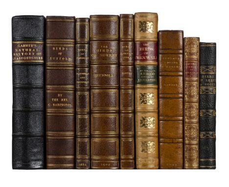
Kennedy (Alexander W. M. Clark). The Birds of Berkshire and Buckinghamshire, 1st edition, Eton: Ingalton and Drake, 1868, 4 hand-coloured albumen prints mounted on card, tissue-guards, half-title discarded, bookplate of George Oakley Fisher (1859-1933), collector, contemporary half morocco, 8vo (17.6 x 11.8 cm), together with: Garner (Robert), The Natural History of the County of Stafford [-Supplement to the Natural History of the County of Stafford], 2 parts in 1 volume, 1st edition, London: John Van Voorst, 1844-60, engraved frontispiece, etched plate, 7 lithographic plates, hand-coloured folding map, extra-illustrated with engraved plates mainly from The Beauties of England and Wales, half-title discarded, frontispiece spotted and offset, light spotting to other plates, short split to one fold of map, contemporary marbled boards, rebacked retaining original roan cornerpieces, 8vo (21.5 x 13.2 cm), Macpherson (Hugh Alexander, & William Duckworth), The Birds of Cumberland critically studied, including some Notes on the Birds of Westmorland, 1st edition, Carlisle: Chas. Thurnam & Sons, 1886, hand-coloured lithographic frontispiece by J. G. Keulemans, folding colour map, top edge gilt, contemporary dark green crushed half morocco gilt by Morrell, 8vo (21.5 x 13.4 cm), Bucknill (John A.), The Birds of Surrey, 1st edition, London: R. H. Porter, 1900, half-title, 6 photogravure plates, folding map, contemporary dark green crushed half morocco gilt by Morrell, 8vo (21.9 x 13.3 cm), Babington (Churchill), The Birds of Suffolk [caption-title], [?Bury St Edmunds, 1883-4], extracted from the Proceedings of the Suffolk Institute of Archaeology and Natural History, pp. 277-557, 7 halftone plates, lithographic map hand-coloured in outline, with descriptive text-leaf (unpaginated), interleaved throughout, ownership inscription, bookplate and annotations of Thomas Tindal Methold (1838-1902) of Hepworth Hall, Suffolk, contemporary half morocco, 8vo (21.6 x 13.6 cm), and 4 similar works, 19th-century county faunas or avifaunas, leather-bound, 8vo (Qty: 9)NOTESTHE DAVID WILSON LIBRARY OF NATURAL HISTORY PART I Gernsheim 436 (Kennedy); Mullens & Swann pp. 326 (Kennedy), 226 (Garner), 374 (Machperson), 105 (Bucknill), 33 (Babington). Kennedy's work was the first ornithology book to be illustrated with photographs.
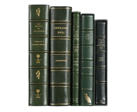
Meinertzhagen (Richard). Birds of Arabia. Edition De Luxe, London: Henry Sotheran Limited, 1980, 12 photographic plates, 19 colour plates, all mounted (most at 3 corners only, apparently as issued), folding map, top edge gilt, original green crushed morocco gilt by Morrell, folio, number 7 of 295 copies (in addition to ten copies lettered A-K), together with: Salomonsen (Finn), Grønlands Fugle. The Birds of Greenland, 1st edition, Copenhagen: Ejnar Munksgaard, 1950, Danish and English text in double column, 52 colour plates, folding map, publisher's prospectus laid in, edges untrimmed, modern green quarter morocco gilt, folio (33 x 22.8 cm), Peregrine Press, Eggs of Rare Limicolae and Variations. Herbert Massey Collection. Illustrated by Edna Bunyard, Leeds: Peregrine Books, 1993, 33 colour plates with captioned tissue-guards, with a list of supplementary subscribers, 3 publisher's prospectuses and an autograph letter from the publisher to David Wilson laid in, top edge gilt, original green half leatherette, slipcase, 4to, number 31 of 50 copies only, Fuller (Errol), The Great Auk, 1st edition, Southborough: Errol Fuller, 1999, mounted colour frontispiece initialled in pencil by Fuller, photographic illustrations throughout, signed by auk egg collector Jack Gibson on both free endpapers, original green half leatherette, slipcase, 4to, number 74 of 400 copies signed by the author, without the additional loose print by Raymond Ching noted in some other copies, Seaton (A. V., editor), Journal of an Expedition to the Feroe and Westman Islands and Iceland, 1833, by George Clayton Atkinson, Newcastle-upon-Tyne: Bewick-Beaufort Press, 1989, colour plates, gilt edges, original quarter morocco, slipcase, 4to, number 84 of 875 copies only, signed by the editor (Qty: 5)NOTESTHE DAVID WILSON LIBRARY OF NATURAL HISTORY PART I

Morton (John). The Natural History of Northampton-shire; with some Account of the Antiquities. To which is annex'd a Transcript of Doomsday-Book so fas as it relates to that County, 1st edition, London: R. Knaplock and R. Wilkin, 1712, p. iv with pasted errata slip, engraved folding map by John Harris, 14 engraved plates, damp-staining to first few leaves, map browned, plates slightly spotted, contemporary panelled calf, rebacked, recornered and relined, gilt arms of Beriah Botfield to sides,rubbed and scuffed, wear to extremities, folio (35.1 x 21.9 cm), together with: Leigh (Charles), The Natural History of Lancashire, Cheshire and the Peak, in Derbyshire: with an Account of the British, Phoenician, Armenian, Gr. and Rom. Antiquities in those Parts, 1st edition, Oxford: for the author, 1700, engraved portrait frontispiece, 2 engraved plates showing coats of arms, double-page engraved map coloured in outline, 22 other engraved plates, variable damp-staining chiefly to margins, affecting images in several plates, frontispiece trimmed and mounted, neatly repaired closed tears in map and plates 8 and 14 touching image in map and skirting plate-mark in plate, plate 11 trimmed to image along fore edge and with extensive repaired tear through image, plate 12 with chip in fore margin repaired verso and fraying along bottom edge, plate 17 with partial loss of image and fore margin extended, plates 18-19 frayed along fore edges, marginal repairs to title-page and text-leaves X2 and 3C1, Postscript leaf following Book III frayed, contemporary marginalia in brown ink, modern half roan, folio (35.2 x 21.9 cm) (Qty: 2)NOTESTHE DAVID WILSON LIBRARY OF NATURAL HISTORY PART I Provenance (Morton): Beriah Botfield (1807-1863), antiquary, industrialist and bibliophile (armorial binding; see University of Toronto, 'British Armorial Bindings', stamp 2, online). ESTC T147393 & R20833; Freeman 2693 & 2211; Upcott pp. 1003-5 & 455-7; Wing L975 (Leigh).
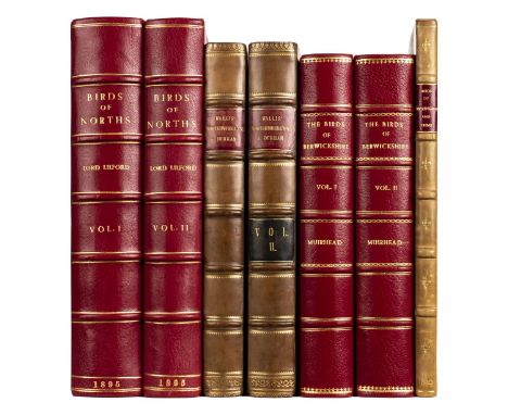
Muirhead (George). The Birds of Berwickshire, 2 volumes, 1st edition, large-paper issue, Edinburgh: David Douglas, 1889-95, half-titles, 10 wood-engraved or etched plates, 2 plans, folding map, wood-engraved vignettes to title-pages and throughout the text, vignettes and 5 of the plates hand-coloured by the artist, top edges gilt, others untrimmed, modern red crushed half morocco, 4to (25.4 x 16.5 cm), number 76 of 100 copies, this copy hand-coloured by the artist John Blair, and inscribed by him 'These reproductions were coloured by me, John Blair' on the limitation page and volume 2 half-title, together with: Lilford (Thomas Littleton Powys, 4th Baron), Notes on the Birds of Northamptonshire and Neighbourhood, 2 volumes, 1st edition, London: R. H. Porter, 1895, half-titles, frontispiece, 24 photogravure plates after Archibald Thorburn, 43 wood-engraved plates after G. E. Lodge, linen-backed folding map, light spotting to outer leaves and a few plates including map, top edges gilt, others untrimmed, modern red crushed half morocco, 4to (28.2 x 21.5 cm), Wallis (John), The Natural History and Antiquities of Northumberland, 2 volumes, 1st edition, London: for the author, 1769, signatures A4 pi2 a-c4 B-3K4, chi2 B-4E4 4F1, contemporary ownership inscriptions effaced from title-page, a few small worm-tracks towards rear of volume 1, closed tear in volume 1 3K3, 19th-century half calf, one label perished, 4to (26.4 x 20 cm), Hartert (Ernst, & Francis C. R. Jourdain), The Birds of Buckinghamshire and the Tring Reservoirs, (Reprinted from Novitates Zoologicae, Vol. XXVII.), Tring: Hazell, Watson & Viney Ld., 1920, 2 halftone plates, original wrappers bound in, another offprint (K. Price, The Birds of Buckinghamshire, from Records of Bucks, Vol. XV, Part 1, 1947) laid in, 20th-century quarter calf, folio (28.2 x 19 cm) (Qty: 7)NOTESTHE DAVID WILSON LIBRARY OF NATURAL HISTORY PART I Freeman 3873 (Wallis); Mullens & Swann pp. 426 (Muirhead), 355 (Lilford). In the octavo issue of Lilford's work Lodge's illustrations are printed in the letterpress rather than as separate plates.
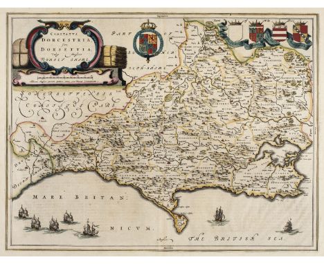
Dorset. Blaeu (Johannes), Comitatus Dorcestria sive Dorsettia; vulgo Anglice Dorset Shire, circa 1660, engraved map with contemporary outline colouring, large ornate cartouche, 385 x 500 mm, Spanish text on verso, together with Saxton (Christopher & Kip William). Dorcestriae comitatus vulgo Dorsett ubi olim Durotriges Insederunt, 1st edition, [1607], hand coloured engraved map, large strapwork cartouche and mileage scale, 280 x 390 mm, Latin text on verso (Qty: 2)
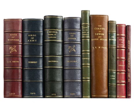
Smith (Alfred Charles). The Birds of Wiltshire, 1st edition, London: for the author by R. H. Porter, 1887, contemporary ownership inscription to title-page, laid-in autograph letter signed from the author (single bifolium), edges untrimmed, modern red quarter morocco gilt, 8vo (22 x 13 cm), together with: Christy (Miller), The Birds of Essex: a Contribution to the Natural History of the County, 1st edition, Chelmsford: Edmund Durrant & Co., 1890, lithographic frontispiece, 2 lithographic plans, 6 pp. advertisements, modern red quarter morocco gilt, 8vo (20.9 x 13 cm), Macpherson (Hugh Alexander), A Vertebrate Fauna of Lakeland, 1st edition, Edinburgh: David Douglas, 1892, half-title, 2 hand-coloured lithographic plates (one signed by J. G. Keulemans), 6 sepia-tinted etched plates, folding map, 20 pp. advertisements, half-title soiled and with 2 ink-stamps, occasional spotting, short closed tear to map touching frame, top edge gilt, modern green quarter morocco gilt, 8vo (23 x 13.4 cm), Ticehurst (Norman F.), A History of the Birds of Kent, 1st edition, London: Witherby & Co., 1909, half-title, 24 halftone plates, folding lithographic map, inscribed 'F.[?] Whitaker, with the writer's kind regards' on the initial blank, ownership inscription to title-page, partly unopened, top edge gilt, others untrimmed, modern blue quarter morocco gilt, 8vo (22 x 15 cm), Ticehurst (Claud), A History of the Birds of Suffolk, 1st edition, London: Gurney and Jackson, 1932, half-title, 18 halftone plates, folding map (neatly repaired), laid-in autograph letter signed from the author to 'My dear Forbes' (probably H. F. Witherby), lacking 2 pp. advertisements, the 4 pp. insert on swan markings noted in some copies, and possibly a list of illustrations (2 pp. at front), modern blue quarter morocco gilt, 8vo (22.6 x 13.8 cm), and 4 others, county avifaunas, leather bindings, 8vo (Qty: 9)NOTESTHE DAVID WILSON LIBRARY OF NATURAL HISTORY PART I Mullens & Swann pp. 545 (Smith), 129 (Christy), 375 (Macpherson), 584 (Claud Ticehurst).
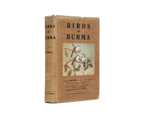
Smythies (Bertram E.) . Birds of Burma, 1st edition, Rangoon: American Baptist Mission Press, 1940, 31 colour plates after A. M. Hughes including frontispiece, captioned tissue-guards, folding map to rear, errata slip to p. xxix, corrigenda leaf, folding map slightly creased along fore edge, original green cloth, dust jacket with pictorial onlay to front panel (rubbed in places, chipping and loss at folds, tape-repairs verso), 8vo (Qty: 1)NOTESTHE DAVID WILSON LIBRARY OF NATURAL HISTORY PART I Provenance: Henry George Seward, British police officer in India (bookplate with crest of the Special Armed Constabulary; ownership inscription). Nissen IVB 882. Signed by the author on the title-page. According to Smythies's introduction to the second edition (Edinburgh, 1953) the first was printed in a run of 1,000 copies, most of which were 'bought by Europeans living in Burma, and left behind by them when they evacuated before the Japanese invasion in 1942 ... The Japanese collected as many as they could and shipped them off to Tokyo, where they housed them in the library of the Royal Veterinary College, later destroyed in an air raid'.
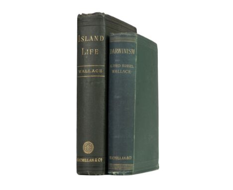
Wallace (Alfred Russel). Island Life: or, the Phenomena and Causes of Insular Faunas and Floras, including a Revision and Attempted Solution of the Problem of Geological Climates, 1st edition, London: Macmillan and Co., 1880, half-title, 3 maps (one hand-coloured), 2 pp. advertisements, wood-engraved maps and plans in text (many full-page), maps and adjacent text-leaves spotted, occasional light spotting elsewhere, brown coated endpapers, ownership inscription to half-title, top edge gilt, original green cloth gilt, spine-ends slightly nicked, upper outer corners bumped, 8vo, together with: ibid., Darwinism, 1st edition, London: Macmillan and Co., 1889, half-title, photographic portrait frontispiece, folding map, 2 pp. advertisements, wood-engraved illustrations throughout, green coated endpapers, original cloth, spine rolled, corners bumped, 8vo (Qty: 2)NOTESTHE DAVID WILSON LIBRARY OF NATURAL HISTORY PART I Provenance ( Darwinism ): Sir Edward Fry (1827-1918), judge and zoologist (bookplate). Freeman 3865 & 3866; Norman 2179 ( Island Life ). Island Life, Wallace's sequel to The Geographical Distribution of Animals (1876), focuses on problems of animal dispersal and speciation and is likewise considered 'one of the foundation works of zoogeography' (Norman).

Drayton (Michael). Two untitled allegorical maps of Middlesex and Hertfordshire and of Anglesey and Caernarvonshire circa 1622, two hand coloured engraved allegorical maps, the map of Anglesey trimmed to image on left hand vertical margin, each approximately 250 x 330 mm (Qty: 2)NOTESOriginally published in the 'Poly Olbion', in two parts 1612 - 1622
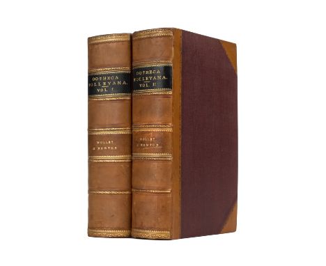
Wolley (John). Ootheca Wolleyana: an Illustrated Catalogue of the Collection of Birds' Eggs begun by the late John Wolley, and continued with additions by the editor Alfred Newton, 4 parts in 2 volumes, 1st edition, London: [John van Voorst-] R. H. Porter, 1864-1907, photogravure portrait frontispiece, 21 chromolithographic plates of bird eggs after J. T. Balcomb or H. Grönvold numbered I-XXI, 16 further lithographic plates (tinted, chromolithographic or uncoloured) depicting birds, nests and landscapes lettered A-P, folding colour map of Lapland, separate list of plates to part 1, original front wrappers for each part bound in at rear, medial blank to volume 2 (between pp. vi and 1) discarded, frontispiece faintly offset, variable spotting to plates I-IX and A-I in volume 1, a few leaves unopened, top edges gilt, contemporary tan half calf, volume 1 spine rolled, large 8vo (25.1 x 15 cm) (Qty: 2)NOTESTHE DAVID WILSON LIBRARY OF NATURAL HISTORY PART I Provenance: Christopher Thomas Dalgety FRGS (1907-1980), ornithologist (bookplates). Anker 541; Freeman 2817; Mullens & Swann p. 661; Nissen IVB 1014; Wood p. 633 ('This famous work'); Zimmer pp. 691-2.
![Drayton (Michael). Allegorical map of Hampshire & Dorset, [1612 or later], hand coloured engraved allegorical map of Dors](https://cdn.globalauctionplatform.com/0450faa8-8d79-4719-b091-abb300cb473d/8905f784-6e4e-44f5-872b-abb400fa740e/468x382.jpg)

* Drayton (Michael). Untitled allegorical map of South Wales and North Somerset, circa 1622, uncoloured engraved allegorical map of the north and south coastlines of the Severn Estuary sometimes referred to as 'The Choirs map' because of the depiction of an English and a Welsh choir and orchestra playing on opposite sides of the river, slight creasing, narrow margins, 250 x 315 mm, mounted, framed and glazed (Qty: 1)NOTESNot examined out of frame.
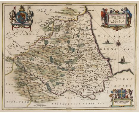
Durham. Jansson (Jan), Episcopatus Dunelmensis vulgo The Bishoprike of Durham, Amsterdam, circa 1650, engraved map with contemporary outline colouring, decorative cartouche, compass rose and numerous rhumb lines, slight fraying to margins but not affecting image, 410 x 510 mm, Latin text on verso, together with Blaeu (Johannes). Episcopatus Dunelmensis vulgo The Bishoprike of Durham, Amsterdam, circa 1648, engraved map with contemporary outline colouring, decorative cartouche and mileage scale, occasional printer's folds and slight creasing, central fold repaired, 385 x 505 mm, Dutch text on verso, with Slater (Isaac & Pigot James). Durham, circa 1855, engraved map with contemporary outline colouring, uncoloured vignette of Durham Cathedral, 235 x 365 mm (Qty: 3)

* Topographical views . A good mixed collection of approximately forty-five engravings, drawings and maps,18th & 19th century, a collection of British and European engraved, lithographic and aquatint topographical views, including examples by or after Kip, J. M. W. Turner, Jukes, Hassell, Stadler, Morris, Daniell, Dixon, Chesham, Papprill, Byrne, Buck, John Sell Cotmam and Bluck, including three pencil drawings of rural scenes by G. T. Craven and a 17th century map with contemporary outline colouring of the islands of Canna, Rùm, Eigg and Muck by T. Pont, 395 x 525 mm, German text on verso (Qty: approx 45)
![Durham. Speed (John), The Bishoprick and Citie of Durham, Thomas Bassett & Richard Chiswell, [1676], hand coloured engrav](https://cdn.globalauctionplatform.com/0450faa8-8d79-4719-b091-abb300cb473d/5e615ea0-83ad-4cb6-9fce-abb400fa8af6/468x382.jpg)

England & Wales. Chatelain (Henry Abraham), Four maps of the British Isles, circa 1720, including Nouvelle carte du Gouvernement civil D'Angleterre et de celuy de la ville de Londres, circa 1720, hand coloured engraved map of England & Wales with a plan of London below, supported by two allegorical vignettes, descriptive French text below maps, 350 x 460 mm, together with Nouvelle Carte de L'Angleterre..., circa 1709, hand coloured engraved map, inset map of Northumberland, tables to vertical margins, old folds, three small holes where old folds cross, 480 x 635 mm, with Carte du Gouvernement Militaire D'Angleterre ou l'on represente l'etat des officiers de guerre..., circa 1739, hand coloured engraved map supported by two allegorical vignettes, French text below map, 350 x 460 mm plus Carte pour l'introduction à l'histoire D'Angleterre..., circa 1710, uncoloured engraved map of the British isles with an inset map of England & Wales, maps surrounded by descriptive text and borders illustrated with circular portraits of kings and queens, old folds, 515 x 600 mm (Qty: 4)

England & Wales. Ortelius (Abraham & Lhuyd Humphrey), Angliae Regni Florentissimi nova descriptio auctore Humfredo Lhuyd Denbygiense, [1601], hand coloured engraved map, some mount staining, occasional marginal repaired closed tears, 390 x 475 mm, Latin text on verso (Qty: 1)NOTESMarcel Van den Broecke. Ortelius Atlas Maps, no. 19.

England & Wales. Rocque (John), England and Wales drawn from the most accurate surveys, Containing all the Cities, Boroughs, Market Towns and Villages..., 1794, large engraved map with contemporary outline colouring on two sheets, large uncoloured cartouche, inset map of the Scilly Isles, some offsetting, overall size 1200 x 985 mm, together with Kitchin (Thomas). Karte von England und Wales..., published F. A. Schraembl, Vienna, 1787, large engraved map with contemporary outline colouring on four sheets, large uncoloured cartouche, stained along central folds, each sheet approximately 660 x 550 mm, with Walch (Johannes). Charte von England und Wallis, Augsburg, 1803, large engraved map after Thomas Kitchin with contemporary outline colouring, on two sheets, inset map of the Scilly Isles, large oval cartouche, each sheet approximately 640 x 1080 mm, plus Pinkerton (John). England Northern part [and] England Southern part, published Cadell & Davies, Longman, Hurst-Rees, Orme & Brown, 1811, engraved map with contemporary outline colouring on two sheets, some dust and finger soiling, the 'Southern part' with an ink mileage scale in the lower margin added by a juvenile hand, each sheet approximately 515 x 720 mm, with another copy of the 'Northern part' (Qty: 11)
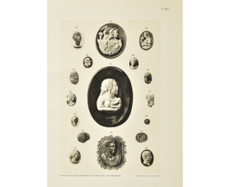
Kibaltchitch (T.W.). Gemmes de la Russie meridionale. Documents inedits sur l'histoire de l'art de la gravure chez les anciens peuples ayant habite la Russie meridionale. Publie per W.Tiktine. Berlin: Reinke et Grounwald, 1910, half-title, photogravure portrait and 20 plates (including hand-coloured map), tissue guards, light toning, original quarter cloth, joints split and frayed at head & foot of spine, slim 4to (limited edition of 250 copies printed), together with: King (Charles William) , Antique Gems and Rings, 2 volumes (text & plates), London: Bell & Daldy, 1872, 75 engraved plates, wood engraved illustrations, original gilt blocked cloth, joints split & frayed, few marks, 8vo, Fossing (Poul) , The Thorvaldsen Museum. Catalogue of the Antique Engraved Gems and Cameos, Copenhagen, 1929, 24 monotone plates, tissue guards, contemporary boards, lower joint torn, marked & scuffed, 4to (Qty: 4)
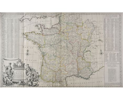
France. Moll (H), A New and Exact Map of France divided into all its Provinces and Acquisitions according to the newest observations..., D. Midwinter, P. Overton and T. Bowles, circa 1710, engraved map with contemporary outline colouring, large uncoloured allegorical cartouche, lower margin frayed and trimmed,old folds, laid on later stiff paper, 610 x 975 mm, together with DelaRochette (Louis). Map of the Empire of Germany including all the states comprehended under that name: with the Kingdom of Prussia &c. Robt. Sayer, circa 1794, large scale map with contemporary outline colouring, engraved by T. Kitchin on two sheets, old folds, each sheet approximately 520 x 1200 mm (Qty: 2)
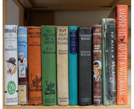
Tolkien (J.R.R.) The Lord of the Rings: The Fellowship of the Ring, 12th impression, 1962; The Two Towers, 10th impression, 1963; The Return of the King, 9th impression, 1962, folding map at end of each, presentation inscriptions, top edge red, original cloth, price-clipped dust jackets, spines and extremities a little rubbed and toned, a few tears, 8vo, with others, mainly P.G. Wodehouse including 1st editions The Clicking of Cuthbert, 1922, Divots (1st US edition), 1927, Enter PSmith, 1935 and Lord Emsworth and Others, 1937, without jackets, varying condition (Qty: 32)
![* Germany. Speed (John), A Newe Mape of Germany, newly augmented, Thomas Bassett & Richard Chiswell [1676], hand coloured](https://cdn.globalauctionplatform.com/0450faa8-8d79-4719-b091-abb300cb473d/778e9620-b42b-4e15-ad02-abb400faabc9/468x382.jpg)
* Germany. Speed (John), A Newe Mape of Germany, newly augmented, Thomas Bassett & Richard Chiswell [1676], hand coloured 'carte-a-figures' map of Germany, with ten costumed figures to the vertical margins and eight oval vignettes of the principal cities along the upper horizontal margin, 405 x 530 mm, mounted with another uncoloured example from the same edition, framed and glazed (Qty: 1)

Gloucestershire. Speed (John), Glocestershire contrived into thirty thre severall hundreds & those againe into foure principall devisions. The citie of Glocester & Bristowe discribed with the armes of such noble men as have bene dignified with ye titlles of Earles & Dukes thereof, Thomas Bassett & Richard Chiswell, [1676], hand coloured engraved map, inset town plans of Gloucester and Bristol, some repaired marginal closed tears, central fold strengthened and repaired on verso, 385 x 515 mm, English text on verso (Qty: 1)

* Gloucestershire. Speed (John), Glocestershire contrived into thirty thre severall hundreds & those againe into foure principall devisions. The citie of Glocester & Bristowe discribed with the armes of such noble men as have bene dignified with ye titlles of Earles & Dukes thereof, Thomas Bassett & Richard Chiswell, [1676], hand coloured engraved map, inset town plans of Gloucester and Bristol, 385 x 510 mm, mounted, framed and glazed, together with Morden (Robert). The County Palatine of Chester, [1695 or later], hand coloured engraved map, 350 x 420 mm, mounted, framed and glazed (Qty: 2)

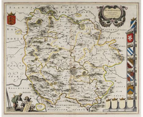
Herefordshire. Blaeu (Johannes), Herefordia Comitatus Hereford-Shire, circa 1650, engraved map with contemporary outline colouring, several repaired marginal closed tears but not affecting image, central fold repaired on verso, 410 x 505 mm, Latin text on verso, together with Saxton (Christopher & Hole W.). Frugiferi AC Ameni Herefordiae Comitatus qui olim pars suit Silurum delineatio, [1637], hand coloured engraved map, slight creasing, 295 x 310 mm, with Speed (John). Worcestershire described, Thomas Bassett & Richard Chiswell, [1676], hand coloured engraved map, inset town plan of Worcester, large strapwork cartouche and mileage scale, central fold strengthened and repaired on verso, slight mount staining and marginal spotting, 385 x 510 mm, English text on verso (Qty: 3)

* Hertfordshire. Blaeu (Johannes), Hertfordia comitatus vernacule Hertfordshire, Amsterdam, circa 1645, engraved map with contemporary hand colouring, slight creasing, some dust soiling and staining, 385 x 500 mm, framed and glazed, together with Norden (John & Kip William). Hertfordiae comitatus A. catifuclanis olim Inhabitatus, [1637], hand coloured engraved map, 280 x 345 mm, framed and glazed, with Cary (John). A Map of Hartfordshire from the best Authorities, published J. Stockdale, 1805, uncoloured engraved map, 390 x 500 mm, mounted, framed and glazed, plus Ramble (Reuben). Hertfordsh. [1845], uncoloured engraved map with coloured lithographic vignettes around the margin, some staining, 155 x 190 mm, mounted, framed and glazed (Qty: 4)

Holy Land. De Wit (Frederick), Terra Sancta sive promissionis olim Palestina recens delineata..., Amsterdam, circa 1680, engraved map with contemporary outline colouring, inset plan of the encampment of the Israelites flanked by the figures of Moses and Aaron, orientated to the west, slight oxidisation to old watercolour, strengthened on verso with archival tissue paper, 460 x 555 mm, together with Anonymous. Delineatio und Beschreibung Palaestinae oder des Gelobten landes sammt der Kinder Israel..., circa 1730, hand coloured engraved map with descriptive key and text in German below map, 410 x 495 mm, with Chatelain (Henri). Vue et Description de Bethleem et de Nazareth..., Amsterdam, [1719], uncoloured engraved panorama with descriptive text below image with four inset topographical views, old folds, 375 x 495 mm (Qty: 3)NOTESEran Laor. nos 860 and 594. The second map is taken from Humphrey Prideaux's 'Altes un Neues Testament in eine Cooexion mit der Juden..., Berlin circa 1725 and the map is after N. Visscher's map of Palestine.

* Isle of Wight. Speed (John), Wight Island, John Sudbury & George Humble, circa 1627, hand coloured engraved map, inset town plans of Newport and Southampton, slight creasing, central fold partially strengthened on verso, one repaired marginal closed tear, upper horizontal margin trimmed and frayed, 380 x 505 mm, framed and double-glazed, English text on verso (Qty: 1)

Cradock (Samuel). A Brief and Plain Exposition and Paraphrase of the Whole Book of the Revelation, from Chapter to Chapter, and from Verse to Verse, 1st edition, London: for T. Parkhurst and J. Robinson, 1696, engraved folding map ('A Map of the Seven Churches of Asia'), small marginal worm-track from L6 to M3, contemporary mottled calf, red spine-label, panelled sides, 8vo (18.6 x 11.5 cm) (Qty: 1)NOTESProvenance: The Evelyn Library, Part I, Sotheby's, 23 June 1977, lot 426 (20th-century bookplate with monogram 'JE'; early ink annotation 'R1' to front pastedown, possibly a pressmark; later pencilled pressmark to front free endpaper). ESTC R31309 (five copies in the USA); Wing C6745. A very good copy.

![Low Countries. Speed (John), A New Mape of ye XVII Provinces of Low Germanie, Thomas Bassett & Richard Chiswell, [1676],](https://cdn.globalauctionplatform.com/0450faa8-8d79-4719-b091-abb300cb473d/d4b10056-2bda-4854-8255-abb400fac975/468x382.jpg)
Low Countries. Speed (John), A New Mape of ye XVII Provinces of Low Germanie, Thomas Bassett & Richard Chiswell, [1676], hand coloured engraved 'carte-a-figure' map, ten costumed figures to vertical margins, eight oval vignettes of the principal cities to upper horizontal margin, several repaired closed tears, central fold strengthened and repaired on verso, 420 x 530 mm, English text on verso (Qty: 1)NOTESFrom John Speed's Prospect Of the Most Famous Parts of the World , with vignette views of Amsterdam, Atrecht, Antwerp, Ghent, Middelburg, Groeningen, Zutphen and Utrecht, as well as various inhabitants of the Low Countries in costume.
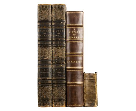
Rapin de Thoyras (Paul). The History of England ..., translated into English with additional notes by N. Tindal ..., 2 volumes, 2nd edition, London: for James, John and Paul Knapton, 1732-1733, titles in red & black with engraved vignette (inner & lower blank margins of volume 1 cropped & repaired), 5 folding engraved maps (one strengthened to fold at verso), 7 engraved genealogical tables (2 folding), final leaf of text in volume 1 with repaired closed tear, scattered spotting, some browning and dust-soiling, armorial bookplate of Purney Sillitoe to upper pastedowns, all edges gilt, contemporary dark turquoise green straight-grain morocco, elaborate gilt and blind decoration, joints and extremities rubbed and scuffed, folio, together with: Raymond (George Frederick) , A New, Universal and Impartial History of England, London: J. Cooke, circa 1788, engraved frontispiece, plates and folding map, a little browned, one plate torn and repaired, one or two others with marginal tears, modern bookplate, modern half calf gilt, folio, and a defective copy of Il Petrarca con nuove spositioni, by Francesco Petrarca, Venice, 1586 (Qty: 4)NOTESPurney Sillitoe (1772-1855) was a wealthy London iron merchant who commissioned Sir John Soane to design & build his neo-classical country house Pell Wall Hall, situated on the outskirts of Market Drayton, Staffordshire (previously Shropshire). Pell Wall was the last completed domestic house by Sir John Soane and was constructed 1822–1828, at a total cost of £20,976.
![[Sansovino, Francesco]. Delle Cose Notabili Della Citta? Di Venetia : Libri II. Ne quali amplamente, e con ogni verita? si co](https://cdn.globalauctionplatform.com/0450faa8-8d79-4719-b091-abb300cb473d/3df1719c-6061-4a26-902e-abb400fc453d/468x382.jpg)
[Sansovino, Francesco]. Delle Cose Notabili Della Citta? Di Venetia : Libri II. Ne quali amplamente, e con ogni verita? si contengono: Usance antiche. Habiti, & vestiti ... Musici di piu? sorte. Con la tavola copiosa, Venice: Zopini & Nepoti, 1596, [16],143,[1]p., printer's woodcut device to title and early manuscript signature William Gorges, A1 torn to lower outer corner with slight text loss, occasional light worm trails, toning & light dust-soiling, 18th century sheep-backed marbled boards, joints cracked and some wear, small 8vo, together with: Whittaker (G. & W.B., publishers) , The Peerage Chart for 1823. House of Lords, London: printed for G. & W.G. Whittaker, [1823], large folded chart mounted on canvas printed in columns, with hand-coloured engravings of the five coronets appropriate for Dukes, Marquesses, Earls, Viscounts and Barons at head, a few old pencilled annotations referring to omissions, the chart folded as issued, 57 x 66.5cm, contained in the original card slipcase, Duren (Johannes van, publisher) , Journal du sie?ge de Philipsbourg, pris le 18 juillet 1734 par l'arme?e de Sa Majeste? tre?s-chre?tienne, commande?e par le mare?chal D'Asfeld ; avec le plan de cette ville ... grave? sur le dessin envoye? a? Versailles par un officier ge?ne?ral, The Hague: J. Van Duren, 1734, 23,[1]pp., folding engraved map, disbound 4to, Company of Scriveners , The Case of the Free Scriveners of London: set forth in a Report from a Committee of the Court of Assistants of the Company of Scriveners, London... at their Court holden the 23rd Day of June 1748, London: Printed in the Year, 1749, additional letterpress title (both with ink stamps), bound with A Report of the Proceedings, particularly on the Commission in Error, in the cause of Thomas Harrison ... against John Alexander ... to be free of the Scrivener's Company, London: J. Williams, 1768, final leaf repaired to margins and with library ink stamp, browning throughout, modern library buckram, 4to, Somerville (William) , The Chase. A Poem, London: G. Hawkins, 1735, e ngraved title (detached), bound with: Croxall (Samuel) , A Sermon Preach'd before the Honourable House of Commons, at St. Margaret's Westminster, on Friday, January xxx, 1729, London: J. Roberts, 1730, bound with: Middleton (Conyers) , A Letter from Rome, shewing an Exact Conformity between Popery and Paganism..., London: W. Innys, 1729, sewing broken and some leaves detached, contemporary marbled boards with remnants of calf spine, text-block broken, worn, 4to, and 3 others (Qty: 8)

The Gentleman's Magazine, or Monthly Intelligencer, 276 volumes, 1731-1877 & 1880-94, a near unbroken run, lacking only 4 half-yearly volumes for 1878 & 1879, illustrated with numerous copper-engraved plates, maps, and engravings to text, including early publications by Samuel Johnson, one of the earliest British publications of the Declaration of American Independence (volume 46, 1776), some browning or spotting and some offsetting to maps and plates, the majority in uniform 20th-century buckram gilt with gilt-titled red leather spine labels and gilt stamp and bookplate of Gray's Inn Library, a few volumes rebound to match, a little rubbed and faded, 8vo (Qty: 276)NOTESThe volumes appear to be largely complete with virtually all their illustrations but the set has not been fully collated and is sold as a periodical, not subject to return. The American maps as listed in David Jolly, Maps of America in Periodicals before 1800 has been checked and all maps inserted and in the text are present. There is some browning and occasional offsetting from facing text, or the maps themselves, a few scattered closed tears and one or two closely trimmed to margin. 'A Map of the Icy Sea...' (1760) is trimmed at head with loss of some title lettering.
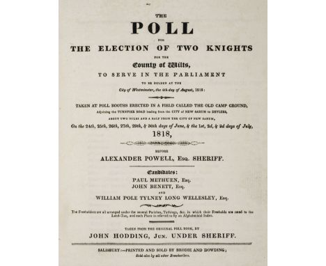
Hodding (John). The Poll for the Election of Two Knights for the County of Wilts, to serve in the Parliament to be holden at the City of Westminster, the 4th day of August, 1818: Taken at Poll Booths Erected in a Field called the Old Camp Ground, Adjoining the Turnpike Road leading from the City of New Sarum to Devizes..., before Alexander Powell, Esq. Sheriff. Candidates: Paul Methuen, Esq., John Benett, Esq., and William Pole Tylney Long Wellesley, Esq., Salisbury: Printed and Sold by Brodie and Dowding, [1818], edges untrimmed, original boards with printed oval title label to upper board, light wear to joints and extremities, slim 4to, together with: Boswell (Edward) , The Civil Division of the County of Dorset, Methodically Digested and Arranged, Sherborne: Printed by W. Cruttwell, [1795], half-title, folding engraved county map by J. Cary, edges untrimmed, original wrappers, rebacked, 8vo, Hinchliffe (Henry John) , Thoughts on the Repeal of the Usury Laws, enclosed in a Letter to a Friend, London: James Ridgway, 1828, [4],35,[3]pp., including the final advertisement leaf, recent printed boards, slim 8vo (Kress C.2088, Goldsmiths 25567), Domestic Prospects , Domestic Prospects of the Country under the New Parliament, London: James Ridgway and Sons,1837, [4],47,[1]pp., half-title, inkstamp of Hastings Russell, 12th Duke of Bedford (1888-1953) at head of title and half-title, recent printed boards, 8vo (Goldsmiths 30222), Bristol Poor , An Act, for the Employment, Maintenance, and Regulation of the Poor of the City of Bristol; and for altering the mode of Assessing the Rates for the Relief of the Poor, and certain Rates authorised to be raised and levied within the said City..., Bristol: Albion Press, 1824, ownership signature of Edward Doggett to upper blank margin of title (adhesive stain to gutter margin), errata slip present at rear, edges untrimmed, contemporary boards, rebacked, 8vo (Qty: 5)

![Middlesex. Drayton (Michael), Untitled allegorical map of Middlesex and Hertfordshire, [1612 or later], hand coloured engrave](https://cdn.globalauctionplatform.com/0450faa8-8d79-4719-b091-abb300cb473d/c8a88176-0acc-4143-90fb-abb400facd92/468x382.jpg)
Middlesex. Drayton (Michael), Untitled allegorical map of Middlesex and Hertfordshire, [1612 or later], hand coloured engraved allegorical map vertical margins trimmed to neatline and extended, toned overall, 255 x 330 mm, mounted, together with Zatta (Antonio). Provincia di Essex..., [and] Provincia di Middlesex..., Venice, circa 1780, two engraved maps on one sheet (as published), each with contemporary outline colouring, some dust soiling, each approximately 205 x 310 mm (Qty: 2)
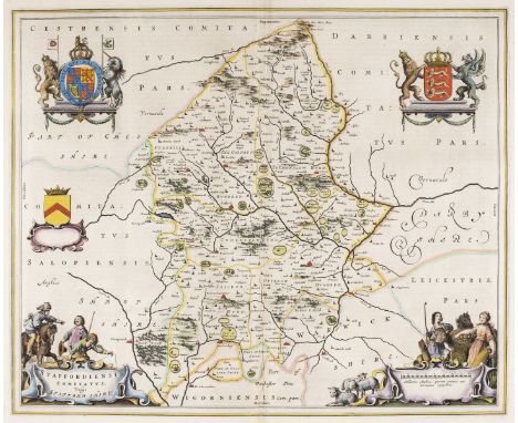
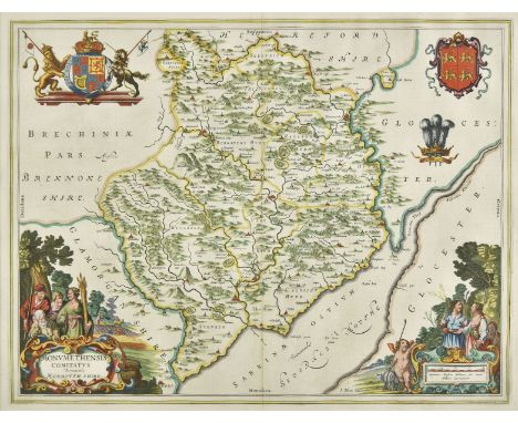
Midland counties. Blaeu (Johannes), Staffordiensis comitatus vulgo Stafford Shire, Amsterdam, circa 1660, hand coloured engraved map, decorative allegorical cartouche and mileage scale, 415 x 505 mm, Spanish text on verso, together with Rutlandia comitatus Rutland Shire, Amsterdam, circa 1645, engraved map with bright contemporary hand colouring, large decorative cartouche and mileage scale, 385 x 505 mm, Dutch text on verso, with Jansson (Jan). Comitatus Cantabrigiensis vernacule Cambridgeshire, Amsterdam, circa 1660, engraved map with contemporary hand colouring, ornate cartouche, and mileage scale, decorated with the twenty-four heraldic shields of noblemen and Cambridge colleges, slight overall toning, margins frayed and chipped, some closed tears affecting image, professionally repaired on verso, the whole backed with archival tissue, trimmed to neatline and margins extended, 420 x 510 mm, no text on verso (Qty: 3)
* Monmouthshire. Blaeu (Johannes), Monumethensis comitatus vernacule Monmouth Shire, Amsterdam, circa 1645, engraved map with bright contemporary hand colouring, large decorative cartouche and mileage scale, 380 x 500 mm, mounted, framed and double glazed, French text on verso, together with Bowen (Emanuel). An Accurate Map of the County of Monmouth Divided into Hundreds..., printed for T. Kitchin, R. Sayer, J. Ryall, Carington Bowles, H. Overton, J. Bowles and H. Parker, [1762], engraved map with contemporary outline colouring and some later enhancement, some creasing, 505 x 415 mm, mounted, framed and glazed (Qty: 2)
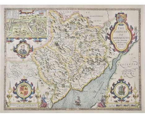
Monmouthshire. Speed (John), The Countye of Monmouth wih the sittuation of the Shire-towne described, John Sudbury & George Huimble, [circa 1627], hand coloured engraved map, inset town plan of Monmouth, large strapwork cartouche and mileage scale, one printer's fold, 385 x 510 mm, English text on verso (Qty: 1)


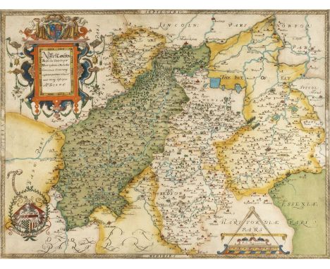
* Northamptonshire & Surrounding Counties. Saxton (Christopher), Northamton, Bedfordiae, Cantabrigiae, Huntingdoniae et Rutlandiae, Comitatuum Vicinarumq. Regionum partium adiacent nova veraq. Descriptio. A. D. 1576, [1579], engraved map with contemporary hand colouring, strapwork title cartouche surmounted by the royal arms to upper left, arms of Thomas Seckford lower left, mileage scale surmounted by dividers, one small printer's fold, 405 x 525 mm, mounted, framed and glazed (Qty: 1)NOTESThe first printed map of Northamptonshire, Bedfordshire, Cambridgeshire, Huntingdon and Rutland.
![* Northamptonshire. Smith (William), Northamptoniae Comitatus Descriptio....., J.Overton [1675 or later], engraved map with c](https://cdn.globalauctionplatform.com/0450faa8-8d79-4719-b091-abb300cb473d/0e2ddf88-9169-4a73-bc82-abb400fad2cd/468x382.jpg)
* Northamptonshire. Smith (William), Northamptoniae Comitatus Descriptio....., J.Overton [1675 or later], engraved map with contemporary outline colouring, elaborate strapwork cartouche and mileage scale, 365 x 480 mm, mounted, framed and glazed (Qty: 1)NOTESWilliam Smith was an antiquary who was a contemporary of Christopher Saxton. He only completed twelve maps which were probably intended for an uncompleted English atlas. The maps were individually first published in 1602, and the plates were acquired by John Overton in 1670. Until comparatively recently their authorship was doubtful and they were known as the 'Anonymous Maps'. All of William Smith's maps are considered scarce.
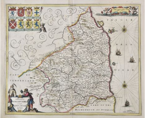
Northumberland. Jansson (Jan), Comitatus Northumbria vernacule Northumberland, circa 1648, engraved map with contemporary outline colouring, decorative cartouche and mileage scale, compass rose and numerous rhumb lines, central fold partially strengthened on verso and with a short split, 410 x 500 mm, Latin text on verso, together with Blaeu (Johannes). Insula Sacra vulgo Holy Island et Farne, Amsterdam, circa 1645, engraved map with contemporary outline colouring, very slight staining to margins, 390 x 475 mm, French text on verso (Qty: 2)

* Northumberland. Speed (John), Northumberland, 1st edition, John Sudbury & George Humble, circa 1611, hand coloured engraved map, inset town plans of Berwick and Newcastle, 385 x 505 mm, framed and double-glazed, English text on verso, together with Cumberland. Speed (John), Cumberland and the Ancient Citie Carlile described with many memorable antiquities therein found observed, Thomas Bassett & Richard Chiswell, [1676], hand coloured engraved map, inset town plan of Carlisle, central fold strengthened on verso, 385 x 510 mm, framed and double-glazed, English text on verso (Qty: 2)
![* British Islands. Mercator (Gerard & Hondius J.). Anglesey, Garnesay, Wight olim vectis [and] Jarsay, [1636], four hand](https://cdn.globalauctionplatform.com/0450faa8-8d79-4719-b091-abb300cb473d/fe0f034c-cac5-4f19-bca4-abb400f7fb28/468x382.jpg)
* British Islands. Mercator (Gerard & Hondius J.). Anglesey, Garnesay, Wight olim vectis [and] Jarsay, [1636], four hand coloured engraved maps on one sheet (as published), overall size 325 x 435 mm, English text on verso, framed and double glazed, together with Drayton (Michael). Title page from the Poly-Olbion, [1612 or later], hand coloured engraved allegorical title page, tipped on to later card, 250 x 160 mm, with Lodge (J.). A Plan of the Navigable Canal from Birmingham in the County of Warwick to the Canal at Aldersley near Wolverhampton..., [and] A Plan of the River Salwarp and of the Navigable Canal from Droitwich to the River Severn in the County of Worcester, published in 'The Gentlemen's Magazine', 1771, two uncoloured engraved canal maps, old folds, 175 x 295 mm and 165 x 350 mm respectively, plus Bowen (Emanuel & Owen John). A Map of Hereford Shire [1720 or later], hand coloured engraved map with an uncoloured strip road map to verso, 185 x 115 mm, mounted (Qty: 5)
Ogilby (John). The Road from London to Aberistwith on the Sea Coast com. Cardigan Wherein are Included the Roads to Oxford and Worcester..., [1675 or later], hand coloured engraved strip road map, ornate decorative cartouche showing a surveyor using a waywiser, central fold partially strengthened on verso, 315 x 445 mm, mounted (Qty: 1)NOTESThe map is sheet no.1 and commences at London and passes through Uxbridge, Beaconsfield, High Wycombe, Stokenchurch and ends at Islip, with an inset road to Oxford.
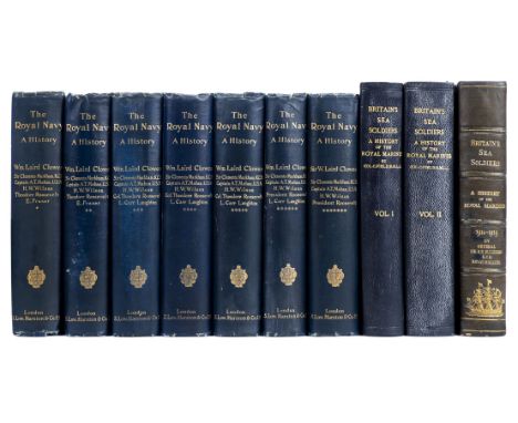
Clowes (William Laird). The Royal Navy. A History from the Earliest Times to the Present, 7 volumes, 1897-1903, photogravure frontispieces, numerous plates and illustrations, some light spotting, top edge gilt, original blue cloth gilt, joints and edges a little rubbed, large 8vo, together with Cyril Field's Britain's Sea-Soldiers, 2 volumes only (of 4, extra-illustrated), 1924 and H.E. Blumberg's Britain's Sea Soldiers. A Record of the Royal Marines during the War 1914-1919, Devonport, 1927 (lacking map) (Qty: 10)

* Ogilby (John). The Road from London to Flamborough Head, com Ebor..., circa 1698, hand coloured engraved strip road map, slight overall toning, 350 x 440 mm, mounted, framed and glazed, together with another example of the same map, with The Continuation of the Road from London to Barwick Beginning at Stilton and extending to Tuxford, circa 1698, hand coloured engraved strip road map, slight overall toning, 325 x 440 mm, mounted, framed and glazed, plus The Road from London to Oakeham in com. Rutland, circa 1698, hand coloured engraved strip road map, slight creasing, 325 x 440 mm, mounted, framed and glazed (Qty: 4)NOTESSheet numbers 41, 6 & 47 respectively
![[Lawrence, T.E.]. A Brief Record of the Advance of the Egyptian Expeditionary Force under the command of General Sir Edmund H](https://cdn.globalauctionplatform.com/0450faa8-8d79-4719-b091-abb300cb473d/657437f8-06bc-434d-acc2-abb400f824d3/468x382.jpg)
[Lawrence, T.E.]. A Brief Record of the Advance of the Egyptian Expeditionary Force under the command of General Sir Edmund H. H. Allenby, July 1917 to October 1918, second edition, His Majesty's Stationery Office, 1919, photographic portrait frontispiece of General Allenby with facsimile signature,113 pages of main text, and 56 single-page colour printed maps, with further descriptive text to each map printed to facing leaf, small area of browning (from an old newspaper cutting) to inner margin of preface leaf (verso) and contents leaf (recto), original grey-blue cloth-backed printed boards, generally a good copy, 4to, together with Thompson (Lieut.-Col. R. R.). The Fifty-Second (Lowland) Division 1914-1918, 1st edition, Glasgow, 1923, colour frontispiece, 15 maps, including 13 folding (of which 11 are bound at rear of the volume), numerous monochrome plates after photographs, partly untrimmed, original blue cloth gilt, a very good copy, thick 8vo, plus Howie (David). History of the 1st Lanark Rifle Volunteers: with list of officers, prize winners, men present at Royal Reviews, &c., 1st edition, Glasgow, 1887, viii, 448pp., 3 photogravure portrait plates, original dark green cloth gilt with regimental armorial to upper cover, a very good copy, 8vo (Qty: 3)NOTESOBrien, T. E. Lawrence: A Bibliography (2000), A 011. A Brief Record is a thorough account of the advance of the Egyptian Expeditionary Force from July 1917 and the end of October 1918, containing many short articles, two of which (the text facing plates 49 and 50, "Sherifian Co-operation in September", and plates 51-53, "Story of the Arab Movement") are by T. E. Lawrence, though unattributed. These were compiled from his notes written originally for the Arab Bureau, which, along with the reports in the Arab Bulletin and The Times, are Lawrence's first published accounts of the Arab campaign. This second edition is the first to be published in England, following the edition issued by the Palestine News in Cairo earlier in the same year.
![Ogilby (John). The Road from London to Holy-head co. Anglesey, [1675 or later], hand coloured engraved strip road map, the ca](https://cdn.globalauctionplatform.com/0450faa8-8d79-4719-b091-abb300cb473d/5c317553-7f52-4af7-96cf-abb400fad791/468x382.jpg)
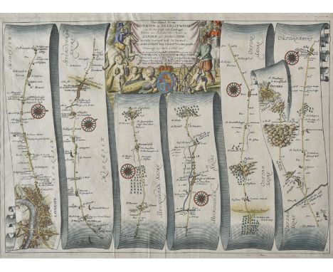
Ogilby (John). The Road from London to Holy-head co. Anglesey, [1675 or later], hand coloured engraved strip road map, the cartouche showing a surveyor using a waywiser, central fold strengthened and repaired on verso, 310 x 435 mm, supplied with sheet of descriptive text (Qty: 1)NOTESThe road commences at London and passes through High Barnet, St. Albans, Dunstable, Fenny Stratford and Stony Stratford and ends at Towcester.
-
109195 item(s)/page