We found 109182 price guide item(s) matching your search
There are 109182 lots that match your search criteria. Subscribe now to get instant access to the full price guide service.
Click here to subscribe- List
- Grid
-
109182 item(s)/page


Lot 825
CAPTAIN GREENVIL COLLINS (fl 1669-1698), Holy Island, Staples & Barwick, handcoloured engraved map with figural title cartouche, 18 3/4" x 23 1/2", together with another Johannes Blaeu (1596-1673), Holy Island and Farne, with title cartouche and Royal Coat of Arms, text verso, 15 1/2" x 18 3/4", both with Hogarth frames (2)


Lot 830
THOMAS KITCHEN (1718-1784), A New Map of Radnorshire, handcoloured engraved map, 8 1/2" x 11", WITH another, John Senax (1678-1740), The Road from Ferrybridge to Boroughbridge, 7" x 9", both with Hogarth frames, and twelve unframed maps including British Isles, Asia, Cherbourg, Paraguay and Tucuman (14)`

Lot 832
CHRISTOPHER SAXTON (1542-1611), and William Hole, Northumbria, handcoloured engraved map with title, compass rose and scale, 11 1/4" x 12", WITH John Speed (1542-1629), Lancaster, uncoloured, engraved map, with town plan and Royal portraits, text verso, 14 3/4" x 19 3/4", both with Hogarth frames (2)


Lot 834
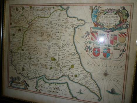
JOHANS BABTIST HOMANN (1664-1724), London from South Mimms to Kingston and from Windsor to Rainham, handcoloured engraved map with Amorial title cartouche, vignette of Father Thames, and bird`s eye views of Windsor Castle, Hampton Court and Kensington Palace below, with Chelsea and Greenwich Hospitals above, 19 3/4" x 20 3/4", WITH Regionis quae est circa Londinum, 1741, handcoloured map with bird`s eye view of Westminster and the Thames along the bottom, 20 1/4" x 23", gilt frames (2) (Illustrated)

Lot 641
Thomas Picken, British 1815-1870- "Side View of the two Northern Entrances of Valencia Harbour, with Cromwell`s Fort and Light House", "Continuation of the Harbour from the Northeastern Entrance, with Caherciveen in the distance", "View from the Island, of part of the Inner Harbour with the River up to Caherciveen", "Western Entrance of the Harbour, with the Skelligs Islands and Light House in the distance", "View of Knightstown on the Island of Valencia and Ferry House from the Railway Terminus at Reenard Point", "Front view of principal northwestern entrance, with Dowlas Head"; lithographs, six, after drawings by William Fitzroy Knight Esq., publ by Day & Son, in original blue boards, with frontispiece engraved map `The Harbour of Valencia" by Alexander Nimmo, 55x36.7cm., (sheet). Note: These lithographs are interesting images of Valentia Island, Co. Gallway, Ireland. In 1858 the first transatlantic cable reached Knightstown and Foilhommerum Bay in 1865 from Heart`s Content, Newfoundland in 1866. Transatlantic telegraph cables operated from Valentia Island until 1966.


Lot 294
Collection of items relating to the Wedgwood factory and familly to include: a Surrender and Admittance document dated October 28th 1847 from Messers Wedgwood to Mr W Heath, an 1890 Indenture between Josiah Wedgwood, John Gustwood and William Andrews relating to a property in New John Street West in Birmingham, a deed map celophane copy of the Eturia works in 1826, also a copy of `Poems` by I.Watts sixth edition originally from the Wedgwood Library, also a copy of `Wedgwoods letters to Bentley` and a copy of `Small beginings the way to get on` with familly inscriptions, also two 1930`s Christmas cards from Wedgwood, also three Wedgwood staff photographs also a 1930`s Wedgwood pattern catalogue.


Lot 2760
A black and white photograph of the actress Harriet Walter wearing a flying coat, helmet and goggles, carrying a map case, gauntlets and parachute, posing with a de Havilland Moth biplane in the background while making a film about Amy Johnson, approx 16cm x 24cm, the Art Deco style mount, approx 48cm x 74.5cm, signed by members of the cast and crew, many indistinct, within a metal frame.


Lot 52
[Ephemera]. A List of Stations and Map of the London, Midland and Scottish Railway, undated; thirteen Great Western Railway hand-bills, 1902, promoting picnic or pleasure parties; a British Railways General Appendix to Working Timetables and Books of Regulations, 1960; and other items, including a British Railways (Northern Region) semaphore distant signal arm.
![[Timetables]. Twelve assorted timetables, including British Railways Southern Region, June-September 1962; June-September 196](http://lot-images.atgmedia.com/SR/10054/2825184/55-2011831102840_468x382.jpg)
Lot 55
[Timetables]. Twelve assorted timetables, including British Railways Southern Region, June-September 1962; June-September 1963; and September 1963-June 1964; and British Railways Western Region, June-September 1962; June-September 1963; and June 1964-June 1965; also a British Railways Southern Region system map, 1959, of carriage print type, 25.5cm x 67cm.

Lot 248
`Memorials of Manchester Streets`, by Richard Wright-Procter, printed Thomas Sutcliffe, Market Place, Manchester, 1874, with numerous illustrations and foldout map of Manchester, together with several tipped-in letters and inked in annotations, bound in brown cloth with black and gilt lettering and decoration, `Memorials of Bygone, Manchester, with Glimpses of the Environs`, by Richard Wright-Proctor, printed by Palmer & Hawe, Manchester 1880, with numerous illustrations, with several tipped-in newspaper articles and annotations, bound in maroon cloth with gilt lettering and decoration, `Among Men and Horses`, by M Horace Hayes, printed by T Fisher Unwin, London 1894, bound in green cloth with gilt lettering and decoration, `The Angler`s Library`, edited by the Rt Hon. Sir Herbert Maxwell bart, volume 2 relating to C-Fish by F G Aflalo, with numerous illustrations of fish and fishing tackle etc, bound in blue cloth with gilt lettering, and a copy of `Noble Forts in Noble Language`, by Henry Southgate, printed by Wardlock & Tyler, London, circa 1890, bound in green cloth with impressed gold and black and red decoration with gilt lettering (4)

Lot 282
A collection of maps comprising "A new and correct map of Durham drawn from the best authorities", being a hand tinted map showing the city of Durham and market towns etc, circa 1800, 16x19cm, framed and glazed, "A map of the Lakes in Cumberland, Westmoreland and Lancaster", hand tinted, circa 1805, 17x33cm, framed and glazed, "A map of Chester, Whitchurch, Oswestry and Elsmere etc", being a hand tinted map, circa 1794, by Cary, 26x20cm, framed and glazed, "A hand tinted map of Cheshire", by T Moule, circa 1880, 20x26cm, framed and glazed, and a modern reproduction map of Lancashire and the Doomsday survey of 1086, framed and glazed (5)

Lot 283
A hand tinted map of Cornwall by John Speed, with an inscription `These maps are to be sold by Roger Rea the elder and younger at the Golden Cross in Cornhill against the exchange 1662`, the map with an inset panel of Launceston, with the Coat of Arms of the royal family and various Coats of Arms of the Dukes of Cornwall, 39x51cm (illustrated)

Lot 284
"The Countye Palatine of Chester with that most Ancient Citie described" this being a hand tinted map of Cheshire by John Speede assisted by William Smyth, the map with inset plan of the city of Chester, with the Coats of Arms of the various Earls of Chester, this double sided map with a description verso of the County of Chester, 40x53cm, framed and glazed (illustrated)

Lot 285
`A Map Of The County Palatine Of Lancaster Divided Into Hundreds And Parishes From An Accurate Survey Made In The Year 1828 And 1829` by G Hennet, London, the fold-out map with the individual coloured hundreds of the county, engraved by James Bingley 57 Charles Street, City Road, London, published by Henry Teesdale & Co, 302 Holburn London May 1st 1830, 163x116cm, this fold-out map comes complete with a leather bound slip case in the form of a book (illustrated)

Lot 286
A collection of loose maps comprising, hand tinted map of The West Division of Paris, published by Baldwin & Cradock, 40 Parternosta Row, April 1st 1834, drawn by WB Clarke, 40x29cm, and another map showing The Eastern Division of Paris, 40x29cm, hand tinted map of Switzerland, published September 2nd 1811 by William Darton Junior, 58 Halbourne Hill, 25x31cm, a hand tinted map of Spain and Portugal printed and published on the 14th April 1813 by William Darton Junior of Halbourne Hill, London, 28x24cm, a hand tinted map of South America, published January 26th 1814 by William Darton of London, with hand written annotations dated 1824, 27x23cm, a hand tinted map of the Netherlands, published August 1st 1811 by William Darton, 58 Halbourne Hill London, 23x28cm, hand tinted map of Arabia, published January 1st 1812 by William Darton Junior of Halbourne Hill, 23x28cm, hand tinted map of Sweden, Norway and Denmark, drawn by J & C Walker, published by Edward Stanford, 6 Charing Cross London, circa 1850, 39x32cm, hand tinted map of Poland and Prussia, published 1st October 1811 by William Darton Junior, 25x29cm, hand tinted map of the Russian Empire, published on 27th December 1811 by William Darton, 25x30cm, hand tinted map of Russia in Europe, published 8th October 1811 by W Darton, 29x24cm (11)

Lot 287
A collection of loose maps comprising " A new map of The County of Derby", compiled and published by Stephen Glover, engraved on steel by Josiah Neele, Strand London, circa 1830, being a hand tinted map showing the various boroughs of Derby, surrounded by sixteen steel engravings or places of local interest to include Chatsworth, Haddon Hall, Buxton Church etc 47x40cm, hand tinted map of Derbyshire, engraved for Lewis topographical dictionary, drawn by J & C Walker, circa 1836, with the various boundaries coloured in, 23x17cm, another hand coloured map of Derbyshire, engraved for Lewis topographical dictionary, circa 1835, 23x17cm, a coloured map of Derbyshire from the encyclopedia Britannica, 9th edition, produced by W & AK Johnston Ltd, lithograph circa 1900, 23x17cm, a guide to knowledge of Derbyshire, made originally from a wood block print, produced by J Archers, 100 Drummond Street Euston Square, circa 1833, with a separate sheet describing the County of Derbyshire (5)

Lot 288
A collection of loose maps of Liverpool comprising, a hand tinted map published 4th June 1795 by J Stockdale of Piccadilly, 20x26cm, a guide to knowledge of Liverpool, being a wood block print, circa 1834, 16x23cm, together with a printed sheet from Pinnock`s guide to knowledge, Liverpool and its environs, engraved from an actual survey made by William Swire in 1823 and 1824 for the history, directory and gazetteer of Lancashire, published by William Wales & Co, Castle Street Liverpool, 41x53cm, Liverpool divisions of extended borough, zincographed at the ordinance survey office Southampton 1885, 33x55cm, Liverpool, produced by A & C Black, Edinburgh, circa 1869, 15x19cm, hand tinted map of Liverpool showing the various wards, engraved by J Gardner, Regent Street London, circa 1850, 32x29cm, a coloured lithograph of the environs of Liverpool, circa 1890 and a similar map, 31x48cm, environs of Liverpool lithograph, circa 1895, and a further map of the environs of Liverpool, lithograph, circa 1895, 31x48cm, a black and white map of Liverpool, published by Cassell, Petter and Galpin, London, circa 1860, 62x42cm and a similar map, Liverpool, drawn and engraved by BR Davies, 16 George Street, Euston Square, circa 1863, 63x42cm (12)

Lot 289
A collection of loose maps of Cornwall comprising a new map of Cornwall drawn from the best authorities by Thomas Kitchin, George engraver to his Royal Highness The Duke of York, circa 1764, 19x25cm, hand tinted map of Cornwall by John Seller circa 1783-87, with description below of the county, dimensions of map 11x14cm, Cornwall by Edward Weller F.R.G.S., published by Cassell, Petter & Galpin of London, circa 1876, this hand tinted map with inset panel of the Scilly Isles, 30x42cm, Cornwall guide to knowledge, this being a wood block print, by J Archer SC, 100 Drummond Street, Euston Square, circa 1833, together with a guide to knowledge leaflet regarding Cornwall, 16x22cm, coloured map of Cornwall by Weller, printed by William Mackenzie, London, Edinburgh and Glasgow, circa 1898, 21x27cm, black and white map of Cornwall by Cole & Roper, circa 1835, with inset panel of the Scilly Isles, 17x23cm, coloured map of Cornwall drawn and engraved by J Archer, with inset panel of the Scilly Isles, 18x23cm, black and white map of Cornwall, printed for Robert Sayer in Fleet Street and Carrinton Bowls in St Paul`s church yard, circa 1765, taken from Ellis`s English Atlas, with inset panel supplement for the Isles of Scilly, drawn from an actual survey by DE & LA Rochette, 20x24cm, a coloured map of Cornwall published 1st July 1809 by J Cary, 21x26cm (9)

Lot 290
A collection of loose maps comprising a black and white map of Lancashire by Johannes Blaeu, circa 1662, showing the various hundreds of Lancashire, with the Royal Coat of Arms, and sailing ships, 36x50cm, a hand coloured map of The Bridgewater Canal published 20th May 1795 by J Stockdale of Piccadilly, 27x20cm, a black and white map of The Lancaster Canal, published January 2nd 1795 by J Stockdale of Piccadilly, 25x20cm, (3)

Lot 292
A collection of loose maps comprising hand tinted map of Chester, published for the proprietors by Vernor & Hood, December 1st 1805, 18x23cm, hand tinted map of Chester from the ordinance survey, circa 1837, 30x20cm, together with some pages relating to the Miscal cooperation boundary`s, a black and white plan of Chester, published June 4th 1795 by J Stockdale Piccadilly, 22x26cm, hand coloured map of Chester boundary`s, circa 1835, 11x9cm, hand tinted map of the voting divisions of The County of Cheshire, showing various hundreds and polling places, circa 1832, 24x28cm, hand tinted map of The City of Chester and the various townships, lithograph produced by C Ingrey, circa 1832, 26x30cm, hand tinted map of Cheshire, circa 1886, 29x45cm, and another hand tinted map of Cheshire, produced by Edward Weller, circa 1870, 29x41cm (8)

Lot 293
Cassell`s universal atlas, produced by Cassell, Petter and Gulpin, London July 1865, being maps of the Great British Railways, showing all the railways and railway stations comprising nine black and white maps, average size 66x46cm, (some duplicated), a black and white map of Tallis`s Railway map of Great Britain, compiled from government documents and the most recent railway information by John Rapkin, circa 1851, 50x36cm, and a hand tinted map of Pompeii, showing the various sites of the forum, tombs, house of pansa etc, published by Baldwin & Cradock, 47 Partinos Road, July 1st 1832, 31x39cm (3)

Lot 39
A vintage England, Wales, and part of South Scotland road map set by G W Bacon & Co, in original leather case and with original boxed `Universal Map Measurer` along with a Bartholomews quarter inch Great Britain map set (23) in original carrying case, including a vintage Breytons complete fitted picnic case


-
109182 item(s)/page