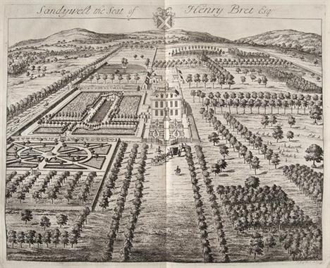
(Sir Robert) The Ancient and Present State of Gloc (Sir Robert) The Ancient and Present State of Glocestershire first edition lacking title but with Author`s Epitaph leaf engraved portrait 8 plates of coats-of-arms double-page map and 61 double-page views by Kip only (of 64 lacking Knole Broadwell and Cirencester House) mounted on stubs with plate of Knole loosely inserted from another copy (a little browned and margins trimmed) a little browned and lightly spotted a few plates creased at fold engraved bookplate of Richard Rawlinson on front pastedown and of Henry Hucks Gibbs on rear contemporary panelled calf rebacked a little worn upper cover detached folio [by W.Bowyer] [1712].
We found 109198 price guide item(s) matching your search
There are 109198 lots that match your search criteria. Subscribe now to get instant access to the full price guide service.
Click here to subscribe- List
- Grid
-
109198 item(s)/page
[Beiier (Christoph)] Schau-Platz dess Niederlandes oder...Beschreibung der siebenzehen Provincien Desselben... half-title with elaborate engraved surround of coats-of-arms of the provinces of the Low Countries title with typographical border and engraved vignette of fishermen at sea folding engraved map 120 double-page engraved plans of towns showing fortifications many with vignette of town mounted on stubs some light browning and soiling engraved half-title defective at lower outer corner and almost detached map torn at inner edge small hole in plate 19 worming to rear inside board slightly affecting final plate contemporary vellum a little stained and worn folio Vienna Michael Thurnmayer 1673.
Boydell (John & Josiah) An History of the River Th 2 vol. first edition with additional letterpress titles `An History of the Principal Rivers of Great Britain` and dedications to George III and Horace Walpole 2 folding engraved maps of the Thames by John Cooke lacking engraved frontispiece of head of Father Thames but with 76 hand-coloured aquatint views 3 folding some light foxing and water-staining mostly marginal but more severe foxing to one or two leaves and water-staining affecting some plates and leaves (particularly in vol.2) offsetting to second map contemporary red straight-grain morocco boards with large double gilt ruled diamond with cornerpieces t.e.g. a little rubbed and marked rebacked with elaborately gilt spines with four gilt-ruled raised bands [Abbey Scenery 432] folio 1794-96.
Commelin (Caspar) Beschryvinge van Amsterdam vol.1 only (of 2 ends abruptly on p.528 but complete vol.1) half-title engraved additional pictorial title title in red and black with woodcut coat-of-arms folding engraved map and 27 plates & plans (20 double-page and/or folding) 3 double-page letterpress tables 39 engraved illustrations most half-page one pasted in folding map with tear to central fold occasional light foxing modern ink inscriptions on front free endpaper contemporary mottled calf spine gilt rubbed upper joint split spine ends worn folio Amsterdam Wolfgang Waasberge... 1693.
Daniell (William) A Voyage round Great Britain... 8 vol. first edition aquatint pictorial dedication leaf 308 superb hand-coloured aquatint plates by and after Daniell each within grey wash border and with thick blank guards without the one uncoloured aquatint plate of Kemaes Head in vol.1 but with the folding map at end of vol.8 errata leaf at end of vol.1 vol.1 with 2 leaves (pp.123-1266) on thicker paper frontispiece to vol.2 misbound in vol.3 final plate in vol.3 loose plate of East Looe in vol.8 with some foxing otherwise a very clean set book-label of George Rennie on front pastedowns handsome contemporary burgundy straight-grain morocco by Fairbairn & Armstrong gilt borders of oak leaves and acorns spines gilt in compartments g.e. signed on front turn-in of vol.1 rubbed scratches to boards joints rather worn some split vol.2 with lower joint repaired lower cover vol.7 detached and head of spine worn [Abbey Scenery 16; Tooley 177] 4to 1814-25. *** “The most important colour plate book on British Topography.” Tooley.
Français (Les) peints par Eux-Mêmes 8 vol. wood-engraved additional pictorial titles and 403 plates only after Gavarni Daumier Daubigny Grandville and others (of 406) all hand-coloured some heightened with gum arabic tissue guards double-page colour map illustrations some foxing but plates generally clean original blind-stamped cloth spines gilt and rather faded rubbed large 8vo Paris L.Curmer 1840-42. *** Without the ninth volume Le Prisme issued separately and often missing.
Grose (Francis) The Antiquities of Scotland 2 vol.. engraved vignette titles and 185 plates only (of 188) also lacking frontispiece and folding map some light foxing title of vol.2 torn and frayed original boards uncut broken rather worn vol.2 lacking boards 1797 § Beattie (William) Scotland 2 vol. engraved additional vignette titles folding map and 117 plates only after Allom Bartlett and M`Culloch (of 118 lacking Kilchurn Castle) foxed contemporary half calf spines gilt rubbed 1838 4to; sold not subject to return (4)
[Hasted (Edward)] [History of Kent] a selection of maps and plates only (no text) large folding hand-coloured engraved map 71 engraved maps plates and plans 6 folding some foxing mostly marginal large map with short tear contemporary half morocco spine gilt t.e.g. rubbed folio [c.1801]; sold not subject to return
(Col. Thomas Holbein) Asian Carpets: XVI. and XVII (Col. Thomas Holbein) Asian Carpets: XVI. and XVII. Century Designs from the Jaipur Palaces text with elaborate chromolithographed borders heightened with gold 150 chromolithographed plates (some double-page) mostly on textured paper plain map and 8 key plates lacking additional title with chromolithographed border ex-library copy with ink accession number and perforated stamp on title but no other leaves library buckram folio W.Griggs [1905]. *** The most sumptuous carpet book ever produced.
Lalauchie (Alexandre) Les Nations: Album des Costu title printed in blue and gold 19 hand-coloured lithographed plates a few plates a little browned light marginal soiling some marginal tears and repairs contemporary green morocco gilt a little worn rebacked preserving most of old spine Paris [1844] § Giafferri (Paul Louis de) L`Histoire du Costume Feminin Français 10 parts 120 pochoir-coloured plates plus one duplicate and 4 advertisement plates at end a little browned and frayed at edges loose in original illustrated wrappers some torn or frayed together in original cloth folder with ties illustration mounted on upper cover worn joints split Paris [1920s] Authenticated Tartans of the Clans and Families of Scotland hand-coloured engraved map 69 mounted colour plates lacking front free endpaper Buchanan bookplates original morocco-backed cloth gilt spine gilt g.e. rubbed corners worn Mauchline [c.1850] ; and 3 others costume v.s. (6)(6)
Melling (Antoine Ignace) and J.-A.Cervini. Voyage lithographed portrait of Melling by Villain after Vigneron engraved map by Tardieu and 72 aquatint plates by Pirniger Gibele & Salathé after Memling each plate with publisher`s small embossed stamp at corner plate 42 with marginal tear crudely repaired with tape some foxing contemporary half morocco spine gilt corners a little worn oblong folio Paris 1826-30.
Robson (George Fennell) Scenery of the Grampian Mo list of subscribers folding hand-coloured engraved map 41 hand-coloured aquatint plates by Henry Morton after the author plates offset and some occasional light foxing but a good clean copy front free endpaper creased bookplate of James Arthur Taylor contemporary half green calf spine gilt with red morocco label rubbed [Abbey Scenery 506; Tooley 405] folio 1819.
Robson (George Fennell) Scenery of the Grampian Mo list of subscribers folding hand-coloured engraved map 41 hand-coloured aquatint plates by Henry Morton after the author light offsetting but plates generally clean book-label of Joyce Cary contemporary half morocco rubbed spine a little worn and defective at head [Abbey Scenery 506; Tooley 405] folio 1819.
(Marshal Louis Gabriel) Mémoires...sur ses Campagn (Marshal Louis Gabriel) Mémoires...sur ses Campagnes en Espagne depuis 1808 jusqu`en 1814 3 vol. including Atlas first edition text with half-titles engraved portrait 2 folding tables foxed and browned George Augustus Sala`s copy with his signature on front free endpaper of vol.1 and cut signature pasted at head of title of vol.2 Atlas with folding engraved map engraved view and 14 folding/double-page plans some incorporating views some foxing light water-staining to lower margin of some plates title loose and repaired at fore-edge contemporary half calf not uniform rubbed text vol. with labels from another set 8vo & folio Paris 1828. *** George Augustus Sala (1828-96) journalist.
Yung (Th.) Album de Vingt Batailles de la Révoluti 20 hand-coloured engraved plates after Yung tissue guards title and text foxed plates lightly browned at edges some nibbling causing slight loss to text but only affecting edge of first few plates original cloth gilt rather worn rebacked Paris [c.1830] § Vierundzwanzig Plane zur Ideen-Taktik der Reuterey von dem General Frafen von Bismarck lithographed throughout with vignette title key and 24 plates most double-page or folding lightly foxed ex-library copy with presentation label on front pastedown contemporary half morocco rubbed rebacked Carlsruhe 1829 § Pascal (Adrien) Histoire de l`Armée et de tous les Régiments 5 vol. 198 wood-engraved plates 176 hand-coloured folding map lightly browned and spotted contemporary roan-backed boards rubbed spines faded Paris 1860-64; and 3 others military v.s. (10)(10)
Faden (William) A New Map of England and Wales Projected upon the Trigonometrical Operations made for the General Survey of the Kingdom engraved map with original hand-colouring in outline 1270 x 960mm. dissected and linen-backed browning and faint offsetting folding into original marbled slipcase with publisher`s label 8vo 1818; with Cary`s Pocket Companion to the Roads of Great Britain 1791; and Crutchley`s Map of the Roads of England Wales & Scotland [c.1850]. (3)
Lewis (Samuel) A Map of England & Wales Divided in large map on a scale of 5 miles to the inch in 4 sections N-E N-W S-E S-W Divisions the first with large vignette view of the General Post Office in London engraved map with original hand-colouring the vignette uncoloured on 9 sheets joined dissected and linen-backed in four large sections each c. 1060 x 870mm. or c.2120 x 1740mm. overall slight offsetting spotting and browning each section folding into green straight grain morocco boards gilt spines worn 8vo [c.1840].
Seale (William Richard) England and Ireland Conta large wall map with inset map of Scotland on a smaller scale at upper right inset chart of the Dover Straits at lower right large allegorical maritime vignette containing title cartouche at lower left two decorative compass roses engraved map with original hand-colouring in outline 1475 x 1520mm. dissected and linen-backed lower right corner section all but detached other wear and splits on folds some section edges creased slight surface dirt and pale browning lacking slipcase Thomas Jefferys late 18th century § Cooper (J.) Map of the British Isles Compiled from Government Surveys large map with decorative title and compass rose at upper right inset maps of the Orkney and Shetland Isles within an ornate border engraved map in original hand-colouring in two vertical sections 1600 x 1500mm. overall if joined dissected and linen-backed two small pigment splashes off the south coast otherwise in good clean condition folding into contemporary embossed morocco travelling slipcase lacking flap 4to [c.1850]. (2)
Greenwood (C.) Map of the County Palatine of Chest large county map with decorative title and compass rose above engraved map with extensive original hand-colouring 1200 x 1545mm. dissected and linen-backed edged in green silk with green endpanels on verso a clean copy folding into green morocco book-style slipcase gilt-tooled and lettered aeg minor scuffs 4to Wakefield W. Fowler and C. Greenwood 1819.
Greenwood (C. & J.) Map of the County of Cornwall large map in 2 vertical sections decorative title in the left sheet vignette view of St Michael`s Mount in the right sheet engraved map with extensive original hand-colouring each section c.1815 x 830mm. or c.1815 x 1660mm. if joined dissected and linen-backed edged in green silk with green endpanels on verso some faint offsetting from border otherwise good folding into green morocco book-style slipcase gilt-tooled and lettered aeg a few scuffs and spine slightly sunned 4to Greenwood & Co. 1827.
Greenwood (C. & J.) Map of the County of Derby fr large map with decorative title at upper right and a vignette view of Chatsworth House at lower left engraved map with original hand-colouring 1550 x 1220mm. dissected linen-backed and edged in green silk with green endpanels on verso offsetting and slight browning folding into green morocco book-style slipcase gilt-tooled and lettered aeg rubbed and spine very slightly sunned 4to Greenwood Pringle & Co. 1825.
Greenwood (C. & J.) Map of the County of Devon fr large map in 3 vertical sections the right sheet with decorative title and vignette view of Exeter Cathedral the left sheet with inset map of Lundy engraved map with original hand-colouring in 3 sections unjoined each c.1935 x 665mm. or c.1935 x 1920mm.overall if joined dissected linen-backed and edged in green silk with green endpanels on verso some faint offsetting from border left section slightly damp-stained folding into green morocco book-style slipcase gilt-tooled and lettered aeg a few scuffs and spine slightly sunned 4to Greenwood Pringle & Co. 1827.
Greenwood (C. & J.) Map of the County of Dorset f large map with decorative title at upper left and a vignette view of Melcombe Regis near Weymouth at lower left engraved map with original hand-colouring 1205 x 1570mm. dissected linen-backed and edged in green silk with green endpanels on verso very slight offsetting folding into green morocco book-style slipcase gilt-tooled and lettered aeg rubbed and spine very slightly sunned 4to Greenwood Pringle & Co. 1826.
Greenwood (C. & J.) Map of the County of Essex fr large map in 2 horizontal sections the upper sheet with decorative title at upper right the lower sheet with a vignette view of Audley End House at lower right engraved map with original hand-colouring in 2 sections unjoined each c.675 x 1575mm. or c.1325 x 1575mm.overall if joined dissected linen-backed and edged in green silk with green endpanels on verso some spotting and slight browning folding into green morocco book-style slipcase gilt-tooled and lettered aeg rubbed and spine very slightly sunned 4to Greenwood Pringle & Co. 1825.
Greenwood (C.) Map of the County of Kent from an large county map with decorative title at lower left and dedication at lower right engraved map with extensive original hand-colouring 1170 x 1780mm. dissected and linen-backed edged in green silk with green endpanels on verso a generally clean copy with minimal offsetting folding into green morocco book-style slipcase gilt-tooled and lettered aeg a few scuffs and spine slightly sunned 4to G. Pringle Jun.r 1821.
Greenwood (C.) Map of the County Palatine of Lanca large county map with decorative title and compass rose above engraved map with extensive original hand-colouring 2055 x 1425mm. dissected and linen-backed edged in green silk with green endpanels on verso one or two faint spots but generally a clean copy folding into green morocco book-style slipcase gilt-tooled and lettered aeg minor scuffs 4to Wakefield W. Fowler and C. Greenwood 1818.
Greenwood (C. & J.) Map of the County of Lincoln large map in 3 horizontal sections with decorative title at upper right and a vignette view of Lincoln Cathedral at lower left engraved map with original hand-colouring each section c.690 x 1545mm. or c.2035 x 1545mm. overall if joined dissected linen-backed and edged in green silk with green endpanels on verso some offsetting folding into green morocco book-style slipcase gilt-tooled and lettered aeg rubbed spine slightly sunned 4to Greenwood Pringle & Co. 1830.
Cruchley (George Frederick) Cruchley`s New Plan of large scale map of London from Highgate to Streatham and Shepherd`s Bush to the east India Dock within engraved border with inset panels of title scale references etc. 2 panels neatly pasted over obscuring imprint below and Cruchley`s name above centre right section inset from another well matched map on the same scale but with different border engraved map 1250 x 1385mm. neatly hand-coloured in concentric circles of blue wash around a red centre this with eccentric black ink lines added within slight offsetting map seller`s label of J. Wyld laid on lower blank panel the map in 2 sections each dissected and linen-backed library stamp on verso folding into contemporary diced roan-backed cloth slip-case with green morocco label mounted on front worn 4to [Howgego 317a (8) or (9)] c.1840. *** Showing the Great Western Railway found in the 1839 imprint (state 8) but lacking the proposed bridge at Charing Cross found in the 1843 (state 10) imprint.
Faden (William) The Country Twenty-Five Miles Roun from Ware to Redhill and from Beaconsfield to Basildon on a scale of one inch to a mile oval title cartouche upper left 3rd edition engraved map in four sections each section c.510 x 630mm. if joined c.1020 x 1260mm. dissected and linen-backed slight browning spotting titles inscribed on each section in pen verso ink stamp of Ilford Municipal Libraries on one section verso original slip-case worn 1815 § Smith & Sons (W. H.). Plan of London engraved map with hand-colouring 590 x 830mm. dissected and linen-backed folding into original cloth boards worn [c.1890]. (2)
Greenwood (C. & J.) Map of London from An Actual S large plan from Dalston to Peckham and from Kensington to Bow Creek with views of Westminster Abbey and St Paul`s at lower corners dedication to King George IV at centre bottom and large decorative title at upper right engraved map with bright original hand-colouring 1280 x 1880mm. dissected and linen-backed edged in green silk with green endpanels on verso some faint offsetting otherwise in good condition folding into green morocco book-style slipcase gilt-tooled and lettered aeg a few scuffs and spine slightly sunned 4to [Howgego 309 (1)] Greenwood Pringle & Co. 1827.
Rocque (John) An exact Survey of the Cities of Lon with The Country near Ten Miles round 2nd edition with corrected title in red and black with engraved allegorical head-piece list of subscribers towns and villages and noblemen 16 double-page map sheets engraved by Richard Parr English title above with dedication cartouche to Lord Burlington in centre of engraved border below each c.510 x 670mm. a few sheet edges frayed one sheet detached one with a tear into the map some browning on central fold slight surface dirt bound out of sequence in later half-calf over marbled boards gilt title on red morocco label to spine folio [Howgego 94 (2)] 1747.
Greenwood (C.) Map of the County of Middlesex fro large county map with decorative title at lower right and vignette view of London from Buckingham House at upper left engraved map with extensive original hand-colouring 1260 x 1350mm. dissected and linen-backed edged in green silk with green endpanels on verso a clean copy folding into green morocco book-style slipcase gilt-tooled and lettered aeg a few scuffs and spine slightly sunned 4to G. Pringle and C. Greenwood 1819.
Greenwood (C. & J.) A group of large scale East Mi including Map of the County of Leicester from an Actual Survey made in the Year 1825 with decorative title at upper right and a vignette view of Chatsworth House at lower left engraved map with original hand-colouring 1195 x 1225mm. dissected linen-backed and edged in green silk with green endpanels on verso offsetting and slight browning folding into green morocco book-style slipcase gilt-tooled and lettered aeg rubbed and slightly scuffed spine slightly sunned 4to Greenwood Pringle & Co. 1826; with the counties of Bedford Huntingdon Northampton Nottingham and Rutland all on the same scale of 1 inch to the mile each with a vignette view most with some offsetting five in uniform slipcases including Leicester one a close match occasional slight scuffing and sunning 1826-31. (6)
Greenwood (C. & J.) A group of large scale West Mi including Map of the County of Warwick from an Actual Survey made in the Years 1820 & 1821 with decorative title at upper right and a vignette view of Warwick Castle at lower left engraved map with original hand-colouring 1380 x 1040mm. dissected linen-backed and edged in green silk with green endpanels on verso very faint offsetting folding into green morocco book-style slipcase gilt-tooled and lettered aeg rubbed and slightly scuffed 4to George Pringle Jun.r 1822; with the counties of Gloucester Salop Stafford and Worcester all on the same scale of 1 inch to the mile 2 with vignette views three with faint offsetting all in near uniform green slipcases occasional slight scuffing and sunning 1820-27. (5)
Greenwood (C. & J.) Map of the County of Somerset large county map with decorative title at upper right and vignette view of Wells Cathedral at lower left engraved map with extensive original hand-colouring 1320 x 1875mm. dissected and linen-backed edged in green silk with green endpanels on verso a generally clean copy with minimal offsetting folding into green morocco book-style slipcase gilt-tooled and lettered aeg a few scuffs and spine slightly sunned 4to G. Pringle Jun.r 1822.
Greenwood (C. & J.) Map of the County of Southampt large map with decorative title at upper left and a vignette view of Winchester Cathedral at lower right engraved map with original hand-colouring 1565 x 1490mm. dissected linen-backed and edged in green silk with green endpanels on verso offsetting and slight browning folding into green morocco book-style slipcase gilt-tooled and lettered aeg rubbed and slightly scuffed spine slightly sunned 4to Greenwood Pringle & Co. 1826; Map of the County of Berks from an Actual Survey made in the Years 1822 & 1823 large map with decorative title at upper left and a vignette view of Windsor Castle at upper right engraved map with original hand-colouring 1010 x 1400mm. dissected linen-backed and edged in green silk with green endpanels on verso some offsetting folding into green morocco book-style slipcase gilt-tooled and lettered aeg rubbed spine slightly sunned 4to Greenwood Pringle & Co. 1824. (2)
Greenwood (C. & J.) Map of the County of Suffolk large map in 2 horizontal sections with decorative title at upper centre and a vignette view of Bury St Edmunds at lower left engraved map with original hand-colouring each section c.690 x 1695mm. or c.1375 x 1695mm. overall if joined dissected linen-backed and edged in green silk with green endpanels on verso offsetting and slight browning folding into green morocco book-style slipcase gilt-tooled and lettered aeg rubbed and slightly scuffed spine slightly sunned 4to Greenwood Pringle & Co. 1825.
Greenwood (C. & J.) Map of the County of Surrey f large county map with decorative title at upper right and vignette view of Kew Palace at upper left engraved map with extensive original hand-colouring 1110 x 1225mm. dissected and linen-backed edged in green silk with green endpanels on verso very faint browning and offsetting folding into green morocco book-style slipcase gilt-tooled and lettered aeg a few scuffs and spine slightly sunned 4to George Pringle Jun.r 1823.
Greenwood (C. & J.) Map of the County of Sussex f large map in 3 vertical sections the left sheet with decorative title at upper left the right sheet with a vignette view of Chichester Cathedral at lower right engraved map with original hand-colouring in 3 sections unjoined each c.1260 x 700mm. or c.1260 x 2070mm.overall if joined dissected linen-backed and edged in green silk with green endpanels on verso some faint offsetting folding into green morocco book-style slipcase gilt-tooled and lettered aeg a few scuffs and spine slightly sunned 4to Greenwood Pringle & Co. 1825.
Lewis (Samuel) A Map of Scotland Divided into Coun large map on a scale of 5 miles to the inch in 3 sections Northern Division Central Division and Southern Division the last with large vignette view of Melrose Abbey engraved map with original hand-colouring the vignette uncoloured on 4 sheets joined dissected and linen-backed in three large sections each c. 640 x 1340mm. or c.1920 x 1340mm. overall if joined slight offsetting and browning each section folding into green straight grain morocco boards gilt spines worn 8vo [c.1845].
Greenwood (C. & J.) Map of the South East Circuit comprising the Counties of Glamorgan Brecon & Radnor decorative title at upper left with vignette view of Llandaff Cathedral below engraved map with extensive original hand-colouring 1445 x 1220mm. dissected and linen-backed edged in green silk with green endpanels on verso some browning and spotting folding into green morocco book-style slipcase gilt-tooled and lettered aeg a few scuffs and spine slightly sunned 4to Greenwood & Co. 1828.
Greenwood (C. & J.) Atlas of the Counties of Engla From Actual Surveys made from the Years 1817 to 1833 engraved title with inset index map and 46 engraved English county and Welsh regional maps each with a vignette view all in original hand-colouring each c.635 x 720mm. some offsetting as usual though some maps barely affected occasional slight surface dirt and minor creasing adjacent to central folds contemporary diced half-calf worn joints cracked gilt title on green morocco label mounted on upper board folio Greenwood & Co. 1834.
Martin (Robert Montgomery) Tallis`s Illustrated At frontispiece of the Great Exhibition engraved vignette title 2 comparative plates of rivers and mountains in the eastern and western hemispheres Railway map of Great Britain 78 maps only with vignette illustrations of 81 and 20 plans of the principal towns of Great Britain and America including a folding plan of London engravings the maps with hand-colouring in outline each c.250 x 350mm. or the reverse occasional surface dust and spotting the frontispiece only spotting plan of London only with splitting and tears half calf marbled boards detached lacking spine worn small folio 1851.
Rocque (John) A Plan of Paris and the Adjacent Cou In which is contained a description of the Villages Seats Great Roads & others Valleys Woods Vinyards Plowd & Pasture Lands Surveyd by Mon.r Roussel 7-sheet map with decorative engraved border the central sheet of the city of Paris separately titled A Plan of Paris &c both the central map and the combined environs reduced from Rocque`s respective 16-sheet versions of 1749 and 1748 7 engraved map sheets each sheet c.770 x 550mm. or the reverse with full margins the map area approx. 1065 x 1410mm. if joined each sheet with a central fold John Rocque n.d. [c.1750].
Seven volumes "The Picture Magazine" circa 1895, with marbled board covers and leather spines, together with a cased set of early 20th century Bartholomew maps to include Cambridge, Potteries, Cheltenham, etc., a cased set of The Royal Automobile Club quarter inch maps, and a collection of "Mapad Map" printing blocks" with turned wood handles
AFTER CAPTAIN G COLLINS "A new and exact survey of the River Dee or Chester-Water by Captain G Collins.... most humbly dedicated and presented to his most sacred Majesty William III", coloured engraved map with figural cartouche, "A correct chart of The English Channel from the No Foreland to the Land`s End.... from Calais to Brest on the coast of France", with panels for Isles of Scilly, Falmouth Haven, Plymouth Sound, Isle of Wight, hand-coloured engraving and "A mapp of Surrey with its hundreds after R Blome"
FRITH (MID 19th CENTURY ENGLISH SCHOOL) "Young gentleman wearing a black coat and brown trousers with top hat in his right hand", watercolour, signed and dated 1851, a County Map of Gloucestershire after Thomas Kitchin, an engraved print `Dawlish` and a quantity of decorative pictures and prints
Scotland – Antique Map a map of Scotland the Hebrides and part of England adapted to Mr Pennant’s Tours published 1st of May 1777 by Benjn White. Uncoloured copper engraved map originally folded for use showing many archaeological features a little weakness in folds but otherwise unblemished. Approx 24x18ins
WWI/WWII group of documents and ephemera relating to Colonel W O Gibbs North Somerset Yeomanry including a good copy letter (with one ms correction in his hand) sent from the Trenches in November 1914 describing in some detail events: ...we lost 22 killed 39 wounded ...amongst the killed are poor Fred Lieber and Jack Davy both killed instantaneously Corporal Thomas who cut my hair one of the Dickinsons and young Glass...the shelling was frightful and very few regiments have had such an introduction to fighting as we have...’ Also included is a large album of press cuttings a Red Cross map of the POW camps of WWII official reports on the Battle of Britain and the Battle of Flanders a signed portrait of Field Marshal Byng and related ephemera
![Loading...](/content/bs/images/ajax-loader.gif)
-
109198 item(s)/page