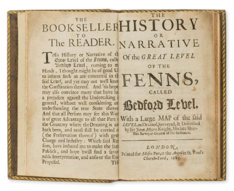
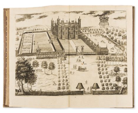
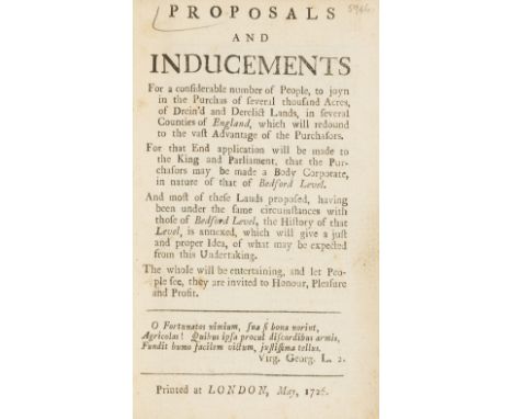
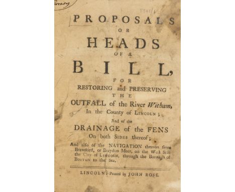
Fens Drainage.- [Rolfe (Jon.)] The Great Law of Marsh Land [at a Session of Sewers holden at Kings-Lynn...], 22pp., wide margins, title without imprint (?divisional title), lacking final blank, some underlinings in ink, title soiled, first few leaves damp-stained and with small hole to outer margin, [Goldsmiths' 5101], [King's Lynn], [1714] bound with Heads of a Bill proposed, to be applied for to Parliament, for preserving the Drainage and Navigations of the Middle and South Levels. 1775, 6pp., drop-head title, [?London], [1775] and M. Observations as to the Present State of the Lands in the Neighbourhood of Spalding...with...an Improvement in the Outfall of the River Welland..., 24pp., with errata leaf at end (slightly defective at lower edge), offsetting to title, Peterborough, J.Jacob, 1791 and Inundation (The), or the Life of a Fen-Man, a Poem. By a Fen Parson, 20pp., price blacked out in ink at foot of title, browned, damp-stained at foot of inner margin, Lynn, by W.Whittingham, [1771], together 4 works in 1 vol., with 2 additional letterpress leaves of minutes c.1777 bound in, one regarding the Bedford Level by Charles Nalson Cole, the other the Adventurers and Free Land Owners at Ely, each paginated "11" on verso, all pamphlets with ink signature "Creasy" in upper left corner of title, manuscript index at beginning, contemporary half calf § Golborne (James) The Report...in pursuance of several Resolutions passed at a Meeting of Land Owners...Interested in the Improvements of the Outfall of the River Ouse..., 44pp., some ink annotations and calculations in margins, Lynn, by W.Whittingham, 1791 bound with Watté (John) The Report...for the better Drainage of the South and Middle Levels of the Fens......by a New Cut or Channel from Eau-Brink to Lynn, 18pp., folding engraved map and table, worming to lower margin, [1791], together 2 works in 1 vol., manuscript index, contemporary half calf, first editions, both rubbed, 4to (2)⁂ A collection of rare pamphlets relating to the Fens, most with only a few copies listed by ESTC but the first item with only one copy (Senate House Library) and the second this copy only in UK, plus one in America (California State Library).


![[New Zealand] Road Map Wellington to Auckland, Department of Maori Affairs, New Zealand after Five Wars, selected list of ref](https://cdn.globalauctionplatform.com/7efd1313-d970-4d9f-8c99-a91100b47ef9/7f88049f-0715-4146-b2cc-8a8703823e3c/468x382.jpg)


![[Chicago Gangland] Frederic M. Thrasher The Gang, A Study of 1,313 Gangs in Chicago 1927 a signed presentation copy from the](https://cdn.globalauctionplatform.com/7efd1313-d970-4d9f-8c99-a91100b47ef9/75495691-850d-44fd-8c27-fc582f67ce06/468x382.jpg)

![[New Guinea] Report on the Territory of New Guinea 1940, Report on Nauru 1939 with folding map, David Bailey Another Image Pa](https://cdn.globalauctionplatform.com/7efd1313-d970-4d9f-8c99-a91100b47ef9/54917110-edc0-4d61-827e-1c948cc3c765/468x382.jpg)


![Fens Drainage.- [Rolfe (Jon.)] The Great Law of Marsh Land [at a Session of Sewers holden at Kings-Lynn...], 22pp., wide marg](https://cdn.globalauctionplatform.com/95c463bf-8582-41f1-88eb-a8f900fdee7b/2b9106aa-4e35-48de-85c1-049d0b3cdf50/468x382.jpg)

![Fens Drainage.- [Leaford (John)] Some Observations made of the Frequent Drowned Condition of the South Level of the Fenns, an](https://cdn.globalauctionplatform.com/95c463bf-8582-41f1-88eb-a8f900fdee7b/9595719f-6ea9-43ae-b195-067b3cba9359/468x382.jpg)

![Cassianus Bassus. Der veltbaw, od' das buch von der veld arbeyt, collation: [*]4 [hand]4 [dagger]4 a-z A-V4 Gothic letter, n](https://cdn.globalauctionplatform.com/95c463bf-8582-41f1-88eb-a8f900fdee7b/954351b7-0531-4bd3-df05-8c1ba52463e9/468x382.jpg)
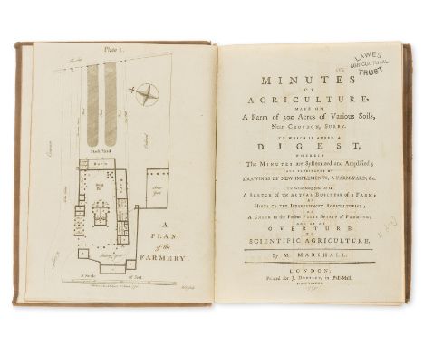
![Britain.- [Agricultural Surveys of the counties of Great Britain], 83 works in 12 vol., many with folding hand-coloured engra](https://cdn.globalauctionplatform.com/95c463bf-8582-41f1-88eb-a8f900fdee7b/0b7ebc8f-b0f6-4561-ed6e-3f222f068c50/468x382.jpg)
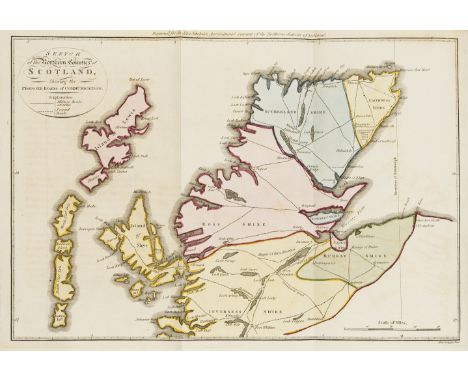
![Scotland.- [Agricultural Surveys of Scottish Counties], 35 vol. including 6 duplicates/later editions, many first editions, m](https://cdn.globalauctionplatform.com/95c463bf-8582-41f1-88eb-a8f900fdee7b/d08d49ae-c8ec-4596-b51e-e171738b3044/468x382.jpg)