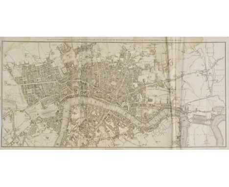

London. Lambert (B.), Plan of the Cities of London and Westminster with the Borough of Southwark exhibiting all the New Buildings to the present year, MDCCCVI, published T.Hughes, 1806, uncoloured map, engraved by Samuel Neele, old folds, some spotting and staining, slight marginal creasing, 350 x 705 mm, together with Russell (J.), London extending from the head of the Paddington Canal West, to the West India Docks East, with the proposed improvements between the Royal Exchange and Finsbury Square, published J.Stratford, 1806,uncoloured engraved map, old folds, closed tears and fraying with slight loss to image, 315 x 530 mm, with Stockdale (J.), A Map of Kent, 1797, uncoloured map, engraved by Samuel Neele, old folds, 355 x 515 mm The first map described, J.Howgego, The Printed Maps of London no.236 state 1. (3)
We found 109198 price guide item(s) matching your search
There are 109198 lots that match your search criteria. Subscribe now to get instant access to the full price guide service.
Click here to subscribe- List
- Grid
-
109198 item(s)/page
Mela (Pomponius). Pomponii Melae de situ orbis Libri III cum notis integris Hermolai Barbari, Petri Joannis Olivarii, Fredenandi Nonii Pintiani, petri Ciacconii, Andreae SChotti, Isaaci Vossii et Jacobi Gronovii. Accedunt Petri Joannis Nunnesii..., et Jacobi Perizonii Adnotata ad Libri I. Capita septemdecim Curante Abrahamo Gronovio, 2 volumes, published Samuelem Luchtmans et Fil, 1748, title in volume one printed in red & black, decorative allegorical frontispiece, folding engraved map (toned), a little dampstaining to endpapers, contemporary mottled sheep with gilt decorated spines, a little worn, 8vo (2)
![Ceylon. Baldaeus (Philippus), Insula Ceylan olim taprobana nunc incolis lankawn, [1672 or later], uncoloured engraved map ori](https://cdn.globalauctionplatform.com/97730585-3d9d-4238-afe7-a67500ac3e34/789419eb-decd-443d-af0a-4cbd93d889ef/468x382.jpg)
Ceylon. Baldaeus (Philippus), Insula Ceylan olim taprobana nunc incolis lankawn, [1672 or later], uncoloured engraved map orientated to the west, old folds, 300 x 395 mm, mounted, together with Regnum Jafnapatnam cum Insulis adjacentibus, circa 1700, uncoloured engraved map,295 x 360 mm, mounted, with The Seige of Colombo under the Command of General Gerard Hulst, circa 1700, uncoloured engraved map, 290 x 360 mm, mounted, together with another six city panoramas and maps of Ceylon and India, each approximately 290 x 365 mm, all mounted This collection would appear to have been originally published in "The True & Exact Description of the Most Celebrated East - India Coast of Malabar and Coromandel and the Island of Ceylon, with all adjacent Countries" by Philip Baldaeus. (9)
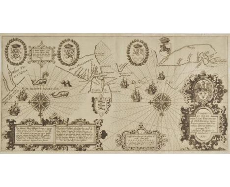
Sea chart. Linschoten (Jan Huyghen), Vera delineatio Maris Insularum Portuum et littorum Septentrionalium ab Insula Toxar per fretum Nassoviacum, published Amsterdam, [1601], uncoloured engraved chart, large ornate strapwork cartouche, compass rose and numerous rhumb lines, old folds, 257 x 540 mm An important early map of the search for the Northeast Passage. The map was drawn by Jan Huyghen van Linschoten to illustrate his account of Willem Barentsz's first two voyages, on which Linschoten was a crew member. It is one of the earliest maps of the area to be made by someone with direct experience of the terrain; Linschotens presence even makes itself felt in the toponymy, with a headland on Nova Hollandia named Linschotens hoeck, which would have been named for him when he was the first to spot it. It is orientated to the south and centred on Vaygach Island, with the Barents Sea on the right and the Kara Sea on the left. A pair of spouting whales and playful seals appear in the water. (1)
![Kent. Speed (John), Kent with her Cities and Earles described and observed, published G.Humble [1611 - 1627], hand coloured e](https://cdn.globalauctionplatform.com/97730585-3d9d-4238-afe7-a67500ac3e34/a6f32b22-43eb-4e31-e176-607dce938eca/468x382.jpg)

*Oxfordshire. Speed (John), Oxfordshire described with ye Citie and the armes of the Colledges of ye famous University, published Roger Rea, circa 1662, hand coloured engraved map, inset town plan of Oxford, vertical margins decorated with eighteen coats of arms, slight overall toning, 380 x 510 mm, mounted, framed and glazed (1)

Preston (Rev. T.A.). The Flowering Plants of Wilts..., Wiltshire Archaeological and Natural History Society, 1888, folding map frontispiece, some spotting, original cloth gilt, rubbed and slightly soiled, a little wear to extremities, together with Lyell (Charles), Principles of Geology..., 2 volumes, 10th revised edition, 1867, wood-engraved plates and illustrations, publisher's adverts at rear of volume 1, hinges to volume 2 slightly cracked, original cloth gilt, a little rubbed and soiled, large 8vo, plus Jardine (William), The Naturalist's Library: Mammalia, volumes 1-4 only, Edinburgh, 1833-36, hand-coloured engraved plates, some leaves and plates detached and several plates missing, contemporary half calf gilt, some wear, plus other natural history interest, mostly 19th century including some with colour plates (3 shelves)
Stevenson (Robert Louis). Kidnapped. Being Memoirs of the Adventures of David Balfour in the Year 1751, 1st edition, 1st issue, 1886, half title, folding map, publisher's catalogue at end dated '5G.4.86', pages 17-32 misbound after page viii and before page 1, scattered light spotting, contemporary previous owner inscription to half title, top edge gilt, modern red morocco gilt, lower band and small are at foot rubbed, slipcase, 8vo Prideaux 18. (1)

British Isles. Custodis (David), Angliae Scotiae et Hiberniae sive Britannicarum Insularum, published Frankfurt, circa 1627, uncoloured engraved map orientated to the east, toned overall, 270 x 310 mm, together with an engraving showing a panorama of London and a scene inside the royal court, 270 x 320 mm, both originally published in 'Laurea Austriaca...,' (2)
Sea charts. Imray (James & Son, publishers), South Atlantic & The North Sea, 1868 & 1873 respectively, uncoloured engraved map, old folds strengthened and repaired on verso, 415 x 630 mm, together with A Plan & Perspective View of the Improved Land of Mingary; with the Improveable Bay of Kitchoan &c. drawn from ye Original Survey of Ardnamurchan, [1734],uncoloured engraved map, inset view of Mingary Castle, old folds, strengthened and repaired on verso, 445 x 600 mm (4)

Maps. A mixed collection of twenty maps, mostly 18th century, including maps by Bonne, Montecalerio, Bellin, Seutter and Lotter, including maps by Bonne of the North East United States and Canada, Bellin's map of Chesapeake Bay and Montecalerio's map of Switzerland, mostly uncoloured, various sizes and condition (20)
Beaufort (Francis). Karamania, or a Brief Description of the South Coast of Asia Minor and of the Remains of Antiquity. With Plans, Views, &c. Collected During a Survey of that Coast, Under the Orders of the Lords Commissioners of the Admiralty, in the Years 1811 & 1812, 1st edition, London: R. Hunter, 1817, seven engraved maps and plates (including folding map frontispiece), engraved illustrations to text, indistinct ink inscription to title, spotting, few dampstains and occasional offsetting, all edges gilt, contemporary red straight grain morocco gilt, spine and extremities rubbed & worn, 8vo Atabey 81; Blackmer 103. "In 1810 Beaufort was appointed senior officer at Smyrna in command of the Frederickssteen; in August 1811 he began the survey of the south coast of Turkey, the first attempt at a description of this area..." (Blackmer). (1)
![Kent. Harris (John), A Map of the County of Kent, [1719], uncoloured engraved map on two conjoined sheets, engraved by Samuel](https://cdn.globalauctionplatform.com/97730585-3d9d-4238-afe7-a67500ac3e34/a3ac2a4e-25f6-4223-d1c8-c6934d6dfff2/468x382.jpg)
Kent. Harris (John), A Map of the County of Kent, [1719], uncoloured engraved map on two conjoined sheets, engraved by Samuel Parker, 'picture frame' cartouche, inset panorama of Dover Castle and Town, the margins decorated with 118 heraldic coats of arms, old folds, slight browning to central fold, 570 x 810 mm (1)
*Gibraltar. [Basire (Isaac)], Plan of the Town and Fortifications of Gibraltar exactly taken on the Spot in the Year 1738, for Mr Tindal's Continuation of Mr Rapin's History of England, circa 1748, hand coloured engraved plan of Gibralter, old folds, 370 x 580 mm, mounted, framed and glazed, together with De Vaugondy (Robert), Carte de la Californie et des Pays Nord-Ouest..., Carte des parties Nord et est de L'Asie..., Partie de la Carte du Capitaine Cluny..., circa 1740, three uncoloured engraved maps, each approximately 300 x 350 mm, with another five engraved maps similar, plus Gardner (Thomas), The Road from Bristol to Weymouth com Dorset, [1719], hand coloured engraved strip road map, 175 x 275 mm, mounted, framed and glazed, with another two framed and glazed maps similar, various sizes and condition (12)

Cambridgeshire. Speed (John), Cambridgshire described with the devision of the hundreds, the Townes situation, with the Armes of the Colleges of that famous Universiti and also the Armes of all such Princes and noble men as have heertofore borne the honorable tytles & dignities of the Earldome of Cambridge, published John Sudbury and George Humble, circa 1627, hand coloured engraved map, inset town plan of Cambridge, twenty-four heraldic shields to borders, slight chipping to margins, strengthened on verso with archival tissue, 390 x 530 mm, no text on verso (1)
Baring-Gould (Sabine). Iceland: Its Scenes and Sagas, 1st edition, 1863, folding map, four colour lithograph plates, 12 wood-engravings, some scattered spotting, front endpaper and half title detached, front hinge broken, bookplate, all edges gilt, original burgundy cloth gilt, spine faded and torn at head, 8vo (1)
London. Paterson (Daniel), Paterson's Twenty Four Miles round London, with Reference to Seats of the Nobility and Gentry. London, published Bowles and Carver, 1804, circular engraved map with contemporary hand colouring, sectionalised and laid on linen, toned overall, long closed tears to linen folds, 670 x 670 mm, contemporary marbled card slipcase with printed label to upper board, worn and a little frayed, together with Coltman (N.), A New Survey of the Environs of London, Extending Twenty Miles North & South from the Parallel of St. Pauls and Twenty Six East & West from the Meridian of the same place, published Laurie & Whittle, 1807, engraved map with contemporary outline colouring, sectionalised and laid on linen, 550 x 680 mm, contained in a contemporary marbled card slipcase with printed label to upper board (printed label has the date 1809) First map described. J.Howgego. The Printed Maps of London, no.212a state 4. The second map, no.241(a), state 1. (2)
![Bible [English]. [The Bible: Translated according to the Ebrew and Greeke ... imprinted at London by Robert Barker, 1611], ge](https://cdn.globalauctionplatform.com/97730585-3d9d-4238-afe7-a67500ac3e34/4c513c6c-7e39-4d91-dda4-e95094c380a7/468x382.jpg)
Bible [English]. [The Bible: Translated according to the Ebrew and Greeke ... imprinted at London by Robert Barker, 1611], general title not present, New Testament title within decorative woodcut border present (with imprint dated 1610), colophon dated 1611, black letter double-column text, bound with an incomplete Genealogies by John Speed (lacking map, one leaf repaired), and incomplete Common Prayer at front, and incomplete Book of Psalms, 1612 at rear of volume, occasional dampstaining mostly at head, dust-soiling and occasional marks, few worm holes, endpapers renewed, contemporary blind panelled calf with brass central bosses and corner pieces, lacking clasps, neatly rebacked and board edges repaired, 4to Herbert 307; Darlow & Moule 238. (1)
Caesar (Gaius Julius). [Opera] quae extant, cum selectis variorum commentariis, quorum plerique novi, opera et studio Arnoldi Montani, Amsterdam: Elzevier, 1661, engraved title, folding engraved map and four full-page illustrations, marbled endpapers with cracked hinges, 19th century calf gilt by J. Mackenzie, joints slightly cracked at head & foot, 8vo Willems 1266. (1)
Fisher (Margery & James). Shackleton, 1st edition, 1957, maps and illustrations, light spotting, original cloth, spine toned, 8vo, with related loose typescript letters, together with Antarctic Research. A Review of British Scientific Achievement in Antarctica, edited by Sir Raymond Priestley and others, 1964, numerous colour and black and white illustrations, a few spots, original blue cloth, with separate map portfolio, slipcase (a few stains), 4to, plus South with Endurance. Shackleton's Antarctic Expedition 1914-1917. The Photographs of Frank Hurley, 2001, numerous half-tone illustrations, original cloth, dust jacket, oblong 4to, with others related including The Antarctic Chef. The Story of the Life of Charles Green. The Cook on Sir Ernest Shackleton's Expeditions to Antarctica on the 'Endurance' in 1914 and the 'Quest' in 1921, compiled by his nephew Roy Cockram, 1999 (inscribed by the author), The Shackleton Voyages. Introduced by Roland Huntford, 2002, Francis Pease's To the Ends of the Earth, 1935 and John Grierson's Challenge to the Poles. Highlights of Arctic and Antarctic Aviation, 1964 (2 cartons )
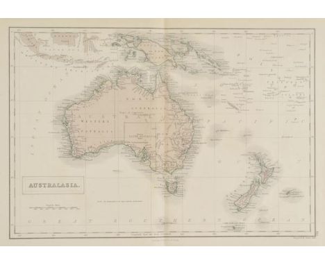
Australia. Black (Adam and Charles, publishers), Atlas of Australia with all the Gold Regions. A Series of Maps from the Latest and Best Authorities, published Edinburgh, circa 1853, printed title with index of maps (slightly toned), six (complete as list) colour lithographic maps, publisher's cloth with gilt map of Australia to upper board, board edges faded, chipped at head of spine with slight loss, slim 4to The maps comprise of: 1. Australasia. 2. Australia. 3. Victoria, New South Wales, and South Australia, inset map of Norfolk Island. 4. New South Wales, inset plan of Sydney. 5. Victoria, inset map of Mount Alexander Gold Region. 6. New Zealand, inset maps of Western Australia, and Van Diemens Land. The first Australian Gold Rush began in May of 1851 when prospector Edward Hargraves found substantial deposits in Bathurst in New South Wales. Hargraves was offered a reward by both the Colonies of New South Wales and Victoria. News soon spread and by the end of 1851 numerous other gold fields were beginning to be exploited in both New South Wales and Victoria. The rush would continue on and off for the rest of the nineteenth century, and increase the population, from 430,000 in 1851 to 1.7million in 1871. Of the six maps in the atlas, maps 2-5 show gold deposits. (1)

Argentina. Peuser (J.), Mapa de los Ferrocarriles de la Rep£blica Argentina..., published Buenos Aires, 1922, large colour lithographic map, sectionalised and laid on linen, twenty-two inset town plans, 2810 x 1535 mm, publisher's cloth gilt boards, somewhat worn and stained, spine a little frayed A very large and uncommon map which clearly shows Argentina's extensive railway network. (1)
Stevenson (Robert Louis). Treasure Island, new edition, 1899, map, black and white illustrations by Wal Paget, Cassell catalogue at end, some light spotting, patterned endpapers, top edge gilt, original blue cloth gilt in bright condition, spine ends a little rubbed, 8vo The first illustrated edition. (1)
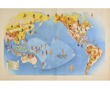
Pacific Ocean. Covarrubias (Miguel), Pageant of the Pacific, published San Francisco, 1940, large chromolithographic pictorial map showing the Americas, Australasia and parts of eastern Asia, China and Japan, slight creasing to central fold, slight marginal dust soiling and staining, 570 x 870 mm The original map (together with five others) was made as wall decoration for the Pacific House, the themed building of the Golden Gate International Exposition, in San Francisco of 1939-1940. The murals were reproduced in a book entitled 'Oceania' together with explanatory text. The work was reviewed by 'The America Anthropolgist' in 1943:"The value of these maps does not rest on their depiction of such usual geographic facts as the location of countries, islands, and rivers..., Peoples of the Pacific, represents in native costume, characteristic inhabitants of the various areas. These figures are shown in larger scale than the appropriate geographic sites to which they are related so that they may be read easily. Both figures and regions are picked out in differentiating colors. Obviously not all of the peoples of the vast Pacific basin are included,but only those whom the author and artist felt were the most characteristic and representative. (1)
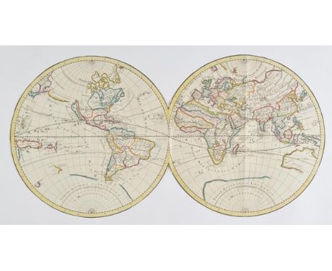
World. [Jaillot (Alexis-Hubert) after Sanson (Nicolas), Mappe-monde Geo-Hydrographique ou Description Generale du Globe Terrestre], circa 1695, engraved hemispheral map on two sheets, contemporary outline colouring, insular California, trimmed to neat lines of the hemipheres, 875 x 450 mm R.W.Shirley. The Mapping of the World. no.462, plate IV. (1)
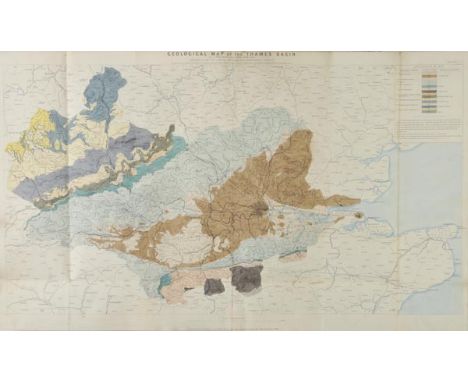
Water supply. Royal Commission on Water Supply. Plans & Diagrams, circa 1870, title printed in gilt on upper board, eight lithographed folding maps with contemporary outline colouring, showing geological formations, maps of rivers and river basins and contour maps, each backed with linen, occasional short splits along old folds, later endpapers, slight dust soiling, upper hinge strengthened with tape, contemporary half morocco gilt, rubbed, worn and stained, old paper stuck to upper board, folio The map titles and their individual sizes are:- Geological Map of the Thames Basin. 600 x 990 mm, Contoured Map of the Thames Basin. 590 x 955 mm, Royal Commission on Water Supply Geological Sections of the Thames Basin. 570 x 945 mm, Map of the Lake District of Cumberland and Westmorland shewing the General Geological Features of the Ground. 340 x 340 mm, Map of Part of the Lake District of Cumberland and Westmorland shewing the Reservoirs and Main Conduits proposed by Messrs Hemans and Hassard in their project for Supplying Water to the Metropolis. 740 x 790 mm, Map of the District at the Head of the River Severn in North Wales shewing the General Geological Features of the Ground. 430 x 430 mm, Map of the District at the Head of the River Severn in North Wales shewing the Reservoirs and Main Conduits proposed by Mr Bateman in his project for Supplying Water to the Metropolis. 940 x 815 mm [and] Ordnance Survey of England and Wales Rivers and their Catchment Basins. 1020 x 965 mm (1)

London. Thompson (George), A New Map of London and its Environs, from an original Survey, Extending 8 Miles East and West 6 1/4 Miles North & South, in which all new and intended Buildings, Improvements &c. are carefully inserted, published Hoare & Reeves, third edition, 1825 [1826], engraved map with contemporary hand colouring, sectionalised and laid on linen, slight dust soiling, marbled endpapers, 650 x 800 mm J.Howgego. Printed Maps of London, no.289(a) state 4. (1)
![South West England. Collins (Captain Greenville), Dartmouth, Plymouth, Portland [and] Falmouth, circa 1730, four uncoloured e](https://cdn.globalauctionplatform.com/97730585-3d9d-4238-afe7-a67500ac3e34/862d2fc2-ac42-4a2b-9d5b-2ac139ba9fa2/468x382.jpg)
South West England. Collins (Captain Greenville), Dartmouth, Plymouth, Portland [and] Falmouth, circa 1730, four uncoloured engraved sea charts, Falmouth with inset map of Helford sound, Plymouth with inset map of Salcombe and Dartmouth with inset map of Tarr bay, slight overall toning, each approximately 455 x 570 mm Originally published in 'Great Britain's Coasting Pilot'. (4)

*Gloucestershire. Speed (John), Glocestershire contrived into thirty-thre severall hundreds & those againe into foure principall devisions. The Citie of Glocester & Bristowe discribed with the armes of such noble men as have bene dignified with ye titlles of Earles & Dukes thereof, published Thomas Basett & Richard Chiswell, [1676]., hand coloured engraved map, inset town plans of Gloucester and Bristol, one vertical crease, very slight worming, repaired on verso, good margins, mounted, framed and double glazed (1)
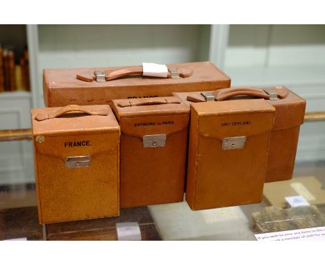
*France. Three map cases containing folding road maps, pub. Edward Stanford, n.d., c.1910, including small leather case with carrying handle with lock, stamped 'Environs de Paris', containing five (complete) colour printed folding maps, sectionalised and laid on linen. marbled end papers and publisher's label to recto, complete with measuring wheel and magnifying glass, case dimensions 195 x 125 x 75 mm, together with, another small leather case with carrying handle with lock, stamped 'France', containing four (complete) colour printed folding maps, sectionalised and laid on line, morocco gilt end papers, complete with measuring wheel, case dimensions 185 x 145 x 115 mm, plus, a larger leather case with carrying handle with two locks, stamped 'France', containing twenty-five (complete) colour printed folding maps, sectionalised and laid on linen, with four additional folding maps of the environs of Paris and a cloth bound route book, lacking measuring wheel, case dimensions 205 x 380 x 130 mm, with Italy, Map case containing twenty-four colour printed maps, pub. Edward Stanford, c.1900, leather map case with carrying handle containing twenty-four colour printed folding maps, sectionalised and laid on linen, marbled end papers, one lock (complete with key), case contains a magnifying glass (possibly not called for), case dimensions 185 x 245 x 100 mm, together with,Switzerland,Map case containing four colour printed maps, pub. Edward Stanford, c.1900, leather map case with lock, four (complete) colour printed touring maps, sectionalised and laid on linen, marbled end papers, case dimensions 200 x 140 x 50 mm (5)
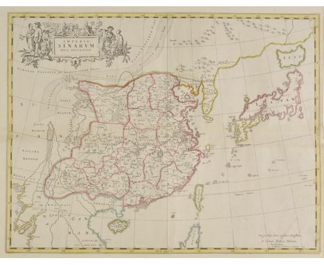
China & Japan. Blaeu (Johannes), Imperii Sinarum nova Descriptio, published J.Covens & C.Mortier, Amsterdam, circa 1710, engraved map with contemporary outline colouring, central fold runs horizontally, 465 x 595 mm A map from Blaeu's Atlas Sinensis, but a later issue by Covens & Mortier. This map covers China, Korea and Japan. Korea is correctly shown as a peninsula and not an island, and China is very accurately depicted -the Great Wall is visible in the north. This is the first European map to show Ezo as an island in Japan. The title cartouche is surrounded by figures in traditional dress.The Atlas Sinensis was the fruit of a unique collaboration between Father Martinus Martini, the Jesuit Superior of Hangchow, and the Amsterdam cartographer, Johannes Blaeu. Father Martino Martini (1614-1661), was a Jesuit missionary who began to compile his own maps based on earlier Chinese sources, including an 1312 manuscript atlas by Chu-Ssu-pˆn. He was taken prisoner by the Dutch in 1654 and sent to Amsterdam. He used the journey to translate Chu-Ssu-pˆns work,with additions and revisions from a 1555 printed atlas by Lo Hongxian. When he arrived, Martini took his work to Johannes Blaeu, and persuaded him to postpone his planned town book of Italy in order to engrave and publish Martinis maps instead. The accompanying text was Martinis personal accountof the decade he had spent travelling in China. The volume of seventeen maps was completed and published in 1655, and marketed as the sixth volume of Blaeu's Atlas Novus. (1)

Indian Ocean. Mortier (Pierre), Carte Particuliere d'une Partie D'Asie ou sont Les Isles D'Andemaon, Ceylan, Les Maldives, Dress‚ sur les memoires le plus Nouveaux, published Amsterdam, circa 1700, large engraved map on two conjoined sheets, with contemporary outline colouring, old folds, 595 x 880 mm (1)

Rutter (John). Delineations of the North Western Division of the County of Somerset, and of its Antediluvian Bone Caverns, with a Geological Sketch of the District, Printed & Published for the Author, Shaftesbury & London, 1829, engraved frontispiece, eleven engraved or lithograph plates, one folding hand-coloured lithograph map, numerous wood engraved illustrations, list of subscribers, modern black half mock leather, 8vo, together with Jewers (Arthur John), Wells Cathedral: Its Monumental Inscriptions and Heraldry. Together with the Hearldry of the Palace, Deanery, and Vicar's Close. With Annotations from Wills, Registers, etc., and Illustrations of Arms, 1892, chromolithograph frontispiece, numerous plates, top edge gilt, remainder untrimmed, endpapers renewed, original blue cloth gilt, folio, (large paper copy), plus a large 8vo 1892 edition of the same title, and [Cottle, James], Some Account of the Church of St. Mary Magdalene, Taunton, and the Restoration thereof..., 1845, engraved frontispiece and lithograph plates, decorative title, occasional spotting, all edges gilt, original cloth gilt, faded, leather title label to spine worn, 8vo, plus five others, mostly Somerset related (11)
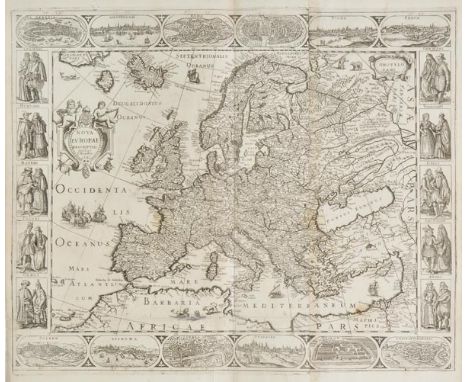
Europe. Hondius (Jodocus), Nova Europae Descriptio auctore I.Hondius, originally published Amsterdam, but this example is a pirated Italian edition, possibly printed in Venice, circa 1642, uncoloured engraved carte-a-figure maps on two conjoined sheets, sparse near contemporary manuscript marginalia, old folds strengthened on verso, slight staining, 450 x 560 mm, no text on verso An unrecorded Italian copy of Hondius's map, probably engraved in Venice, perhaps by the little known publisher Stefano Scolari. The paper bears a watermark of an anchor in a circle, surmounted by a six pointed star (possibly Heawood 8) which indicates the paper to be Italian and of the period. The map appeared together with six other similar examples at a Sothebys auction, several of which bore the date 1642, and had numerous vignette views to the borders reversed, so that the Tower of London appeared on the left rather than the right of the image, however, this error is not present on the views of Venice, Rome and Constantinople.The map is based upon Hondius's map of Europe published in 1623. The title appears in the Atlantic Ocean in a cartouche flanked by two putti and crowned by a clock. The imprint appears in a cartouche to the upper right hand corner. The town views to the upper and lower border are based upon Hondius's 1619 map of Europe, and the costumed figures in the side borders upon Blaeu's 1617 map of Europe. The geographical content is based upon the previous wall maps, which were in turn a reduction of Blaeu's wall map of Europe. Not recorded in Schilder's Monumenta Cartographica vol. VI. (1)

*Cheshire. Saxton (Christopher & Hole William), Cestriae comitatus Romanis Legionibus et Coloniis olim insignis vera et absoluta descriptio, 1st edition, 1607, hand coloured engraved map, 'open book' cartouche, 260 x 305 mm, framed and double glazed, Latin text on verso, together with, Morden (Robert),The County Palatine of Chester, [1695 or later], uncoloured engraved map, creased and heavily stained along central fold, some staining and spotting, 350 x 415 mm, framed and glazed, with Saxton (Christopher & Hole William), Monumethensis comitatus quem olim incoluerunt silures, circa 1610, hand coloured engraved map, 385 x 355 mm, framed and glazed (3)
![Caesar (Julius). Rerum ab se gestarum commentarii, [edited by Giovanni Giocondo], Paris, Michel Vascosan & Jean Rogny, 1543,](https://cdn.globalauctionplatform.com/97730585-3d9d-4238-afe7-a67500ac3e34/f444359a-8d00-4902-bedc-b6ae189a1acf/468x382.jpg)
Caesar (Julius). Rerum ab se gestarum commentarii, [edited by Giovanni Giocondo], Paris, Michel Vascosan & Jean Rogny, 1543, half-page woodcut map of France (printed from two blocks), half-page woodcut map of Spain, 5 woodcut illustrations to text, woodcut initials, including 8 fine large initials taken from the alphabet designed by Oronce Fine for his Protomathesis of 1532, short closed tear to foot of title at inner margin, a very good copy with clean margins, modern quarter calf incorporating old marbled boards, with vellum tips, folio Adams C37. Mortimer 124. Excellent copy of this folio history of France in the period of the Roman Empire, printed by 'the prince of French renaissance printers'. (1)


*Middlesex. Speed (John), Midle-sex described with the most famous Cities of London and Westminster, published Henry Overton, circa 1712, hand coloured engraved map, inset town plans of Westminster and London, inset vignettes of Saint Peters and Saint Pauls, occasional repaired marginal closed tears, 385 x 505 mm, mounted, framed and glazed (1)
![Asia. Blaeu (G.), Asia noviter delineata, published Amsterdam, [1621 - 1630], uncoloured engraved carte-a-figure map of Asia,](https://cdn.globalauctionplatform.com/97730585-3d9d-4238-afe7-a67500ac3e34/3ec99fbe-edab-4645-9ff4-ad7cff09b52d/468x382.jpg)
Asia. Blaeu (G.), Asia noviter delineata, published Amsterdam, [1621 - 1630], uncoloured engraved carte-a-figure map of Asia, slight worming, one small hole affecting image, one small rust mark, slight fraying to margins but not affecting image, 415 x 555 mm, no text on verso The map is a reduction of Blaeu's wall map of 1608, with the majority of the cartography based on Portuguese mapmakers. Korea is shown as a long thin island, and much of the coast line of Borneo, Java, and Celebes is uncertain,although many of the islands that make up the Philippines are much more accurately portrayed. Japan is based on the work of Luis Teixeira. There is a decorative border on three sides: above are nine birds-eye views of the principal Asiatic cities including Jerusalem, Damascus, Aden, and Macao; flanking the map are ten costumed figures representing the national dress of various Asiatic inhabitants.This is the second state with the name changed in the cartouche from Guil:Janssonio to Guiljelmo Blaeu, and no text on the verso. The map would be incorporated into Blaeu's first atlas the Appendix in 1630. Later states with text on the verso would appear in all Blaeu's subsequent atlases. (1)

![Africa. Blaeu (G.), Africae nova descriptio, published Amsterdam [1621 - 1630], uncoloured engraved carte-a-figure map, one s](https://cdn.globalauctionplatform.com/97730585-3d9d-4238-afe7-a67500ac3e34/67747b68-5e4c-4fdc-80a0-3f949ac4573d/468x382.jpg)
Africa. Blaeu (G.), Africae nova descriptio, published Amsterdam [1621 - 1630], uncoloured engraved carte-a-figure map, one small rust mark affecting imgae, slight worming, 415 x 555 mm, no text on verso A fine example of Blaeu's folio carte-a-figure map of Africa. The map is a reduction of Blaeu's wall map of 1608, with the coastal cartography based on Portuguese sources. A decorative border surrounds three sides: above are nine birds-eye views of the principal European cities including Tunis, Algiers, Alexandria, and Tangiers; flanking the map are ten costumed figures representing the national dress of various African inhabitants.This is the third state with the name changed in the cartouche from Guil:Janssonio to Guiljelmo Blaeu, and no text on the verso. The map would be incorporated into Blaeu's first atlas the Appendix in 1630. Later states with text on the verso would appear in all Blaeu's subsequent atlases. (1)
Savary des Brutons (Jacques). The Universal Dictionary of Trade and Commerce, Translated from the French of the Celebrated Monsieur Savary... With Large Additions and Improvements, Incorporated throughout the Whole Work; Which more Particularly Accomodate the same to the Trade and Navigation of these Kingdoms, and the Laws, Customs, and Usages, to which all Traders are Subject, by Malachy Postlethwayt, 2 volumes, 1st edition in English, printed for John and Paul Knapton, 1751-55, engraved allegorical frontispiece to volume I, titles printed in red and black with engraved vignettes, engraved vignette at head of dedication leaves, 24 folding engraved maps, folding tables, lacking text pages 409-420 & 597-612 in volume I, inksplashes to one index leaf, a few folding tables and Europe map at end of volume II, small wormtracks just in image of two South America maps, a couple of folding fore margins a little frayed, a few other marginal wormtracks or holes, light marginal toning to volume II title, a few light spots, contemporary calf gilt, joints cracking, lacking most labels, rubbed and scuffed, folio ESTC N35479. First published in Paris in 1723. (2)
![Schedel (Hartmann). Liber Chronicarum [Nuremberg Chronicle], 1st edition, Nuremberg: Anton Koberger, 12 July 1493, a fragmen](https://cdn.globalauctionplatform.com/97730585-3d9d-4238-afe7-a67500ac3e34/2046a8ac-0464-4a23-9e6c-eae0d3c0cad1/468x382.jpg)
Schedel (Hartmann). Liber Chronicarum [Nuremberg Chronicle], 1st edition, Nuremberg: Anton Koberger, 12 July 1493, a fragment of 55 leaves only from this work, including 18 leaves of the index, and the double-page woodcut map at the end with colophon (map torn with various losses and repaired), numerous woodcut illustrations and portraits, four leaves with large circular excisions with professionally repaired, other repairs to margins and closed tears etc., some dust-soiling and ferw marks, 20th century quarter calf by Sangorski & Sutcliffe (with receipt dated 25th Sept 1968), folio, leaf size 444 x 305 mm Provenance: Sotheby's 23 January 1968, Printed Books, lot 320, purchased by Kenneth Tomkinson for £30. (1)

Mantell (Gideon). The Fossils of the South Downs; or Illustrations of the Geology of Sussex, 1st edition, Lupton Relfe, 1822, 42 aquatint plates, mostly of fossils and geological specimens, including single-page map, and 4 plates with hand-colouring, small stain to map, marbled edges and endpapers, contemporary dark green half morocco lettered in gilt to spine, slightly rubbed and a little scuffed to extremities (generally in good condition), 4to Dean 40. (1)
Shaftesbury (Anthony, Earl of). Characteristicks of Men, Manners, Opinions, Times, 3 volumes, 5th edition, John Baskerville, Birmingham, 1773, engraved portrait frontispiece, titles with engraved vignettes, engraved headpieces, light offsetting and marginal toning, Brooklyn Public Library ink stamps to title of volumes II & III, library labels at front, portrait of Anthony, 1st Earl of Shaftsbury, 1813, to volume I, contemporary calf gilt, joints cracking, a little rubbed, 8vo (Gaskell 49), together with Gilpin (William), Remarks on Forest Scenery, and other Woodland Views, Relative chiefly to Picturesque Beauty Illustrated by the Scenes of New Forest in Hampshire, 3 volumes, 3rd edition, 1808, 31 etched and aquatint plates, folding map, some light offsetting, previous owner inscription, contemporary half calf, joints cracking, loss at foot of volume II spine, 8vo, with three others: William Gilpin's Observations on the River Wye, 5th edition, 1800, Richard Graves' Tne Spiritual Quixote: Or, the Summer's Ramble of Mr. Geoffrey Wildgoose. A Comic Romance, 3 volumes, 1774 and The Works of Lawrence Sterne, 4 volumes, 1803 (13)
London. Stanford (Edward, publisher), Stanford's New Map of the County of London on the Scale of four inches to one mile, 1894, large colour lithographic map, on five sheets, sectionalised and laid on linen, each sheet with marbled endpapers, slight staining, 1380 x 2120 mm, contained in contemporary morocco book box, heavily worn and rubbed (1)
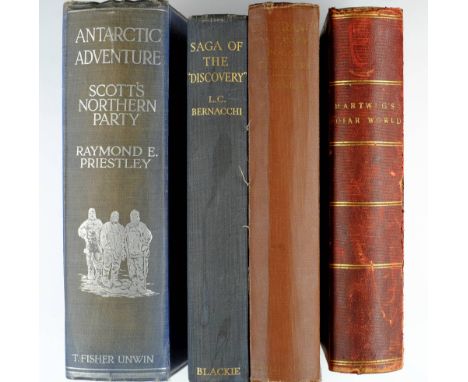
Priestley (Raymond E.). Antarctic Adventure. Scott's Northern Party, 1st edition, 1914, three folding maps (one torn in half), numerous half-tone illustrations, a little light spotting, top edge gilt, original blue cloth silver, spine faded, a few damp stains to lower cover, 8vo, together with The Life of Sir Ernest Shackleton, by Hugh Robert Mill, 1st edition, 1923, half-tone illustrations, scattered light spotting, previous owner inscription, original blue cloth gilt, spine ends a little rubbed, 8vo, plus Endurance. An Epic of Polar Adventure, by Frank Arthur Worsley, 1st edition, 1931, map, portrait frontispiece, sepia illustrations, light spotting, original cloth, spine faded, edges rubbed, 8vo, with five other related including G. Hartwig's The Polar World, 1869, Herrbert Ponting's The Great White South, 5th impression, 1923, L.C. Bernacchi's Saga of the "Discovery", 1st edition, 1938 and Richard Evelyn Byrd's Antarctic Discovery, 1st UK edition, 1936 (8)

London. Davies (B.R.), Davies's New Map of the British Metropolis, The Boundaries of the Boroughs, County Court Districts, Railways and Modern Improvements, published Edward Stanford, circa 1870, engraved map with contemporary hand colouring, sectionalised and laid on linen, 740 x 930 mm, contained in publisher's cloth slip case with printed label to upper board (1)
France. Bowles (Thomas, publisher), The War in France with the Fortifycations and Harbours of Toulon, Marseilles, Brest, St Malo, Port Louis &c, circa 1710, engraved map with contemporary outline colouring, vertical margins decorated with inset maps of ports and harbours, laid on later paper, torn with substantial loss to lower right corner, 625 x 990 mm, together with Chatelain (Henry Abraham), Carte du Gouvernement civil de France, published Paris, circa 1720, uncoloured engraved chart showing scenes of French legal and political events, 340 x 435 mm, with Bonnart (R.), L'arm‚e du Prince d'Ornage deffaite devant Mont Cassel, circa 1690, uncoloured engraving of the Battle of Cassel after F.Van der Meutten, some dust soiling, occasional marginal closed tears, slight loss to right hand margin, 630 x 520 mm (3)

Landor (A. Henry Savage). In The Forbidden Land..., 1899, 251 black and white illustrations plus a map, some light toning, bookplates to front pastedown, contemporary gilt-decorated red calf, boards lightly rubbed, spine slightly faded and rubbed to head and foot, 8vo, together with Walton (Izaak & Cotton, Charles), The Compleat Angler, 1904, numerous black and white illustrations, some light spotting, bookplate to front pastedown, contemporary gilt-decorated black morocco, spine slightly rubbed, 8vo, plus Hemingway (Ernest), The Old Man and the Sea, 1st UK edition, 1952, original blue cloth in dust jacket, covers slightly rubbed to head and foot, 8vo, plus other 19th and early 20th-century illustrated literature and miscellaneous reference, including The Newgate Calendar..., volumes 1-4, by Andrew Knapp & William Baldwin, 1824, Arthur Rackham, Walter de la Mare, Charles Kingsley, some decorative leather bindings, some original cloth, condition is generally good/very good, 8vo (3 shelves)

British Isles. Blaeu (Johannes), Britannia prout divisa suit temporibus Anglo-Saxonum praesertin durante illorum Heptarchia, published Amsterdam, circa 1645, engraved map with bright contemporary hand colouring, 415 x 530 mm, Latin text on verso One of the most decorative maps of the British Isles ever produced. The dramatic vignettes to each side of the map depict the founders of each of the seven Kingdoms, whilst the scenes on the right show the conversion of the various Kingdoms to Christianity. Closely modelled on Speeds Heptarchy of 1611, the vignettes surrounding Blaeu's version have been completely redone in the grand style of Dutch contemporary paintings. R.W.Shirley. Early Printed Maps of the British Isles, no.549. (1)

London. Smith (Charles), Map of the Country Twelve Miles round London, 1823, engraved map with contemporary outline colouring, sectionalised and laid on linen, engraved by W.R. Gardner, slight overall toning, 735 x 850 mm, contained in later card slip case J.Howgego. Printed Maps of London, no. 288, state 2. (1)
![Europe. Speed (John), A New Mappe of the Romane Empire, published Thomas Bassett & Richard Chiswell, [1676], hand coloured en](https://cdn.globalauctionplatform.com/97730585-3d9d-4238-afe7-a67500ac3e34/5cbc2820-013c-4899-a1d5-a887cac82513/468x382.jpg)
Europe. Speed (John), A New Mappe of the Romane Empire, published Thomas Bassett & Richard Chiswell, [1676], hand coloured engraved 'carte a figure' map with ten costumed figures to the vertical margins and six oval vignettes of principal cities along the upper horizontal margins, one small hole to left hand margin just affecting the neat line, 395 x 510 mm, English text on verso (1)
![Cornwall. Saxton (Christopher), Promontorium hoc in Mare Projectum Cornubia dicitur, [1579], engraved map with contemporary h](https://cdn.globalauctionplatform.com/97730585-3d9d-4238-afe7-a67500ac3e34/90fc1ee0-e14d-49d6-c56c-dc6af642b8a7/468x382.jpg)
Cornwall. Saxton (Christopher), Promontorium hoc in Mare Projectum Cornubia dicitur, [1579], engraved map with contemporary hand colouring, 'bunch of grapes' watermark, large strapwork cartouche and mileage scale, the title cartouche surmounted with the royal coat of arms, with an additional armorial of Thomas Seckford, good margins, slight overall toning, 370 x 490 mm Engraved by Lenaert Terwoort. (1)

London. Mogg (Edward), London in Miniature with the surrounding Villages, An entire new plan..., 1840, engraved map with contemporary outline colouring, sectionalised and laid on linen, endpapers with publisher's advertisements, 515 x 940 mm, contained in a contemporary card slip case with printed label to upper board, also retaining eight leaf index in paper wrappers J.Howgego. Printed Maps of London, no. 237, state 21. (1)

-
109198 item(s)/page