We found 108737 price guide item(s) matching your search
There are 108737 lots that match your search criteria. Subscribe now to get instant access to the full price guide service.
Click here to subscribe- List
- Grid
-
108737 item(s)/page


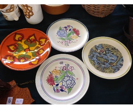
Lot 311
A most interesting Georgian bandsman’s painted tambourine, the 3” deep outer frame, incorporating 6 thin brass jingles, painted with Garter Stars on the outside, and trophies of instruments on the inside, with maker’s name “G. Ouldney (? unclear) & Co, 20 Soho Square, London”, thin hide top secured by 8 iron screw tensioners, diameter 18”, with old stitched repair, and traces of a map (?) drawn on the inside. Basically Good Condition for age (small splits to hide) Plate 64. Note: tambourines were used by bandsmen of African origin in the Brigade of Guards.

Lot 93
COLLECTABLE BOOKS - excellent assortment of 34 collectable books covering subjects such as travel, art and nature. Highlights include 1914 Mersey Docks diary (with maps of all docks), Pattisons Cyclists Road Map of North Wales, Motor Tours from Cardiff (Whereiwent Series), 1914 Panama Canal Souvenir, Story of Baden Powell (Begbie 1900), English in Egypt with Life of General Gordon (Sangster), Tripoli to Godames, Antoine Watteau Masters of Painting (1925 The Studio - S Sitwell), Silver & Golden Bells (Constance Harrison 1898) and many more.


Lot 98
The Graphic Parliamentary Map, General Election 1892: Showing The members Returned For County Divisions And Boroughs...coloured lithograph, 80 cm x 57 cm and contained within oak frame with gilt slip Viscount Newark, Charles Pierrepont, 4th Earl Manvers was returned as Parliamentary Member for Newark


![[TOPOGRAPHY]. SOMERSET Baynham, Arthur Wilfrid. Memorials of Ash Priors, limited edition of 150, Commin, Exeter, 1908, green](https://cdn.globalauctionplatform.com/e7dde010-1548-4a54-ab3b-a49d00b6b3b8/c5bb9ca4-1bf4-4f9f-90c2-332fdf3d45bd/468x382.jpg)
![[TOPOGRAPHY]. SOMERSET Savage, James. History of the Hundred of Carhampton, in the County of Somerset, one of just twelve lar](https://cdn.globalauctionplatform.com/e7dde010-1548-4a54-ab3b-a49d00b6b3b8/ffa4eeee-d792-43e0-e6b6-c7406e270caf/468x382.jpg)
![[TOPOGRAPHY]. DEVON Page, John Lloyd Warden. The Coasts of Devon and Lundy Island, large paper copy, limited edition of 250,](https://cdn.globalauctionplatform.com/e7dde010-1548-4a54-ab3b-a49d00b6b3b8/fb8a7eb1-1f96-4b0e-f9ad-cf3a5a834c1e/468x382.jpg)
![[TOPOGRAPHY]. CORNWALL Lysons, Rev. Daniel & Samuel. Magna Britannia; being A Concise Topographical Account of the Several Co](https://cdn.globalauctionplatform.com/e7dde010-1548-4a54-ab3b-a49d00b6b3b8/e9e57c58-f69b-4be5-8bd3-133c47e5f9e9/468x382.jpg)
Lot 1105
[TOPOGRAPHY]. CORNWALL Lysons, Rev. Daniel & Samuel. Magna Britannia; being A Concise Topographical Account of the Several Counties of Great Britain, Volume the Third, containing Cornwall, for Cadell & Davies, London, 1814, full calf (rebacked), folding map, thirty-eight engraved plate illustrations (as called for), quarto.
![[TOPOGRAPHY]. DEVON Rowe, J. Brooking. A History of the Borough of Plympton Erle, the Castle and Manor of Plympton, limited e](https://cdn.globalauctionplatform.com/e7dde010-1548-4a54-ab3b-a49d00b6b3b8/13ac95c6-df94-4661-c1d3-98c5028dab52/468x382.jpg)
Lot 1109
[TOPOGRAPHY]. DEVON Rowe, J. Brooking. A History of the Borough of Plympton Erle, the Castle and Manor of Plympton, limited edition of 250, Commin, Exeter, 1906, later half morocco gilt, top edges gilt, twenty-five plates illustrations (as called for), further text illustrations, folding map, quarto.
![[TOPOGRAPHY]. WEST COUNTRY GENEALOGY Rawle, Edwin John. Records of the Rawle Family, limited edition 43/75, Barnicott & Pearc](https://cdn.globalauctionplatform.com/e7dde010-1548-4a54-ab3b-a49d00b6b3b8/e33e0991-f611-47e5-b81e-928068e36582/468x382.jpg)
Lot 1112
[TOPOGRAPHY]. WEST COUNTRY GENEALOGY Rawle, Edwin John. Records of the Rawle Family, limited edition 43/75, Barnicott & Pearce, Taunton, 1898, armorial brown buckram gilt, top edges gilt, portrait frontispiece, folding map, six plate illustrations (as called for), quarto; Wyndham, The Hon. H.A. A Family History 1688-1837: The Wyndhams of Somerset, Sussex and Wiltshire, first edition, Oxford University Press, London, 1950, green cloth, dustjacket, two plate illustrations, octavo; and Sanders, James. History of the Siderfin Family of West Somerset, first edition, Southwood, Exeter, 1912, crimson cloth, folding pedigree, octavo, (3).
![[TOPOGRAPHY]. DEVON Page, John Lloyd Warden. An Exploration of Dartmoor and its Antiquities, first edition, Seeley & Co., Lon](https://cdn.globalauctionplatform.com/e7dde010-1548-4a54-ab3b-a49d00b6b3b8/5260cadb-8681-4c8a-87cc-8f603f71c482/468x382.jpg)
Lot 1114
[TOPOGRAPHY]. DEVON Page, John Lloyd Warden. An Exploration of Dartmoor and its Antiquities, first edition, Seeley & Co., London, 1889, quarter leather, top edges gilt, twenty plate illustrations (as called for), folding map, quarto; Baring-Gould, S. Devonshire Characters and Strange Events, first edition, Bodley Head, London, 1908, dark grey cloth, top edges gilt, plate illustrations, quarto; and four other works, (6).
![[TOPOGRAPHY]. DEVON Britton, J. & Brayley, E.W. Devonshire Illustrated in a Series of Views, Fisher, London, 1832, quarter le](https://cdn.globalauctionplatform.com/e7dde010-1548-4a54-ab3b-a49d00b6b3b8/c6ab58bc-9d94-4bf1-90e4-2e6aff40765e/468x382.jpg)
![[TOPOGRAPHY]. SOMERSET Collinson, Rev. John. The History and Antiquities of the County of Somerset, three volumes plus index,](https://cdn.globalauctionplatform.com/e7dde010-1548-4a54-ab3b-a49d00b6b3b8/55df81b5-376f-4851-c802-a9f9eac07844/468x382.jpg)
Lot 1122
[TOPOGRAPHY]. SOMERSET Collinson, Rev. John. The History and Antiquities of the County of Somerset, three volumes plus index, Cruttwell, Bath, 1791, half leather, folding map frontispiece and plate illustrations (supplied in facsimile), large quarto (index volume bound with extra, interspersed blanks); and Weaver, Rev. F.W. & Bates, Rev. E.H., editors. Index to Collinson's History of Somerset, Barnicott & Pearce, Taunton, 1898, tan cloth, quarto, (5).
![[TOPOGRAPHY]. DEVON Polwhele, Richard. The History of Devonshire, three volumes, facsimile of 1797-98 editions, Kohler and Co](https://cdn.globalauctionplatform.com/e7dde010-1548-4a54-ab3b-a49d00b6b3b8/31dd8be3-aed5-40af-a0fe-76d129f956d0/468x382.jpg)


-
108737 item(s)/page