We found 109198 price guide item(s) matching your search
There are 109198 lots that match your search criteria. Subscribe now to get instant access to the full price guide service.
Click here to subscribe- List
- Grid
-
109198 item(s)/page


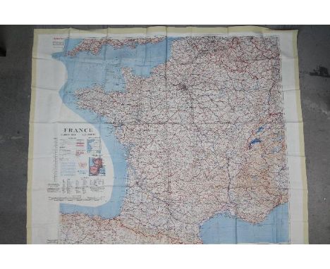

Lot 63
Three maps- WW1 Commemorative French Silk Map 1914-1918- "La France Reconstituee Parla Victoire Du Droit 1914-1918". Fair condition. 45 cm by 45 cm. (2) Bacon's Flexible Map of London 1890, in green leather case, 72 cm x 50 cm. (3) Road Map of India, 1973- Produced by Govt. Survey of India. Folding map in black covers. Good condition. (3 items)Condition Report: London 1890 map, generally good condition, some foxing. India Road map, generally good condition, some creasing, some pencil annotations to the margin.


Lot 253
A collection of Nineteen Norfolk Broads and Norfolk/North Suffolk related titles, including Arthur Henry Patterson: 'Man and Nature on the Broads', [1895], 1st edition, illustrated throughout, 143pp, 4to, original pictorial cloth gilt and silvered; plus Payne Jennings: 'Sun Pictures of the Norfolk Broads', 1892, 2nd edition, illustrations from photographs throughout, original pictorial cloth gilt; plus Ernest Suffling: 'The Land of the Broads', circa 1887, 20th thousand, folding map (with tear i.e. in two parts, but complete), illustrations throughout, original pictorial cloth gilt; plus facsimiles of Blake's Yachting List catalogues 1908 and 1916, each limited editions (numbered 556 & 479 of 2000 respectively), each oblong, original wraps, in original card slipcases; plus 'Twelve Colour Pictures of Lowestoft', souvenir view album circa 1900 published by Jarrold and Sons, 12 coloured plates as called for, oblong 4to, original cloth backed boards; plus Longe: 'Lowestoft in Olden Times', Lowestoft, McGregor & Fraser, 1905, 2nd edition, frontis, original pictorial wraps; plus Eric Pursehouse: 'Waveney Valley Studies', Diss, Diss Publishing Co, circa 1965, original printed wraps; plus Chambers: 'A Corner of Suffolk', Lowestoft, Flood & Son, 1926, frontis, original printed paper covered boards; plus 10 others including Dutt, M.R. James, Fendall 'A Norfolk Anthology' 1972 1st; 'The Norfolk Broads Holiday Book and Pocket Pilot' 1952 1st, plus a 19th Century souvenir view album 'The Royal Cabinet Album of Sea Side', London, Rock & Co., 24 humorous views on 12 folding concertina leaves, original decorative cloth gilt, etc. (19)


Lot 288
India.- Richardson (David Lester) The Anglo-Indian Passage; Homeward and Outward, first edition, inscribed and initialled by author, frontispiece, map, 11 plates, illustrations, occasional marginal spotting, publisher's advertisements bound at beginning, later half-morocco, a little rubbed, 12mo, 1845.

Lot 283
Europe.- Craven (Elizabeth) A Journey through the Crimea to Constantinople, 6 engraved plates, 1 folding, large folding map, short tear expertly repaired (L1), corrections inserted by hand, occasional faint marginal spotting, bookplate, contemporary calf, rebacked, slight bumping to corners, 4to, 1789.
Lot 37
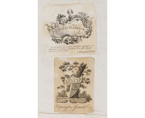
NO RESERVE Garrick's copy.- Caesar (Gaius Julius) Quae Extant Omnia, Italica versione, translated by Hermolaus Albritius, parallel Latin and Italian texts, title in red and black and with engraved device, engraved frontispiece, portrait, folding map, 4 plates (2 folding) and illustrations, occasional mostly marginal foxing or spotting, contemporary vellum, spine in compartments and with red morocco label, spine and corners worn, but binding holding firm, rubbed, 4to, [Venice], [Societas Albritiana], [1737].⁂ Provenance: David Garrick (1717-1779) actor and theatre manage; his nephew Carrington Garrick (bookplates).

Lot 281
Egypt.- Sonnini (C. S.) Travels in Upper and Lower Egypt: undertaken by order of the Old Government of France, 3 vol., first English edition, engraved frontispieces, 36 engraved plates, large folding map (tear), faint off-setting, contemporary calf, rebacked, a little rubbed, slight bumping to corners, 8vo, 1799.
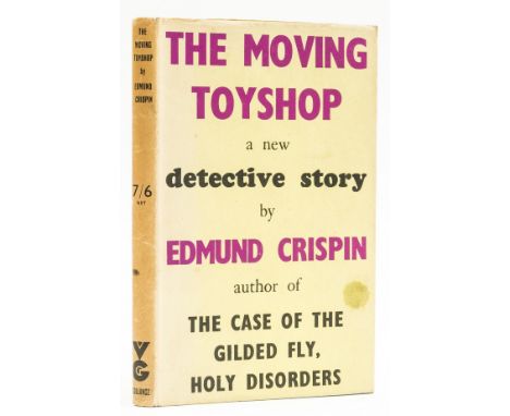
Lot 144
Crispin (Edmund) The Moving Toyshop. A Detective Story, first edition, map illustration, original cloth, light fading to spine, dust-jacket, spine a little browned, spine ends and corners a little chipped, splash mark to upper panel, but an excellent copy overall, 8vo, 1946.⁂ An attractive copy of this classic work of detective fiction, dedicated to Philip Larkin, The Moving Toyshop provided the inspiration for the merry-go-round dénouement of Hitchcock's Strangers on a Train.
Lot 291
NO RESERVE Italy.- Martyn (Thomas) A tour through Italy. Containing full directions for travelling in that interesting country, new edition, folding hand-coloured engraved map, contemporary tree calf, spine gilt, spine worn and repaired, Printed for C. and G. Kearsley, [1791] § Dickens (Charles) Pictures from Italy, first edition in book form, initial and final advertisement f., half-title, wood-engraved illustrations by Samuel Palmer, occasional spotting, original blue cloth, small nick at head of spine, little light staining, [Eckel, p. 126; Pine-Coffin 844(5)], 1846; and 6 others, 18th & 19th century works on Italy, v.s. (8)
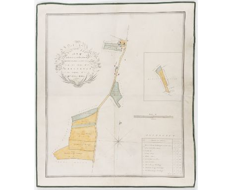
Lot 56
Worcestershire Estate Map.- Ladbury (R., surveyor) Map of Estate in the Parishes of Flyford Flavel and Kington in the County of Worcester the Property of Mrs Nancy Eades, manuscript estate map with watercolour wash, on vellum, title within cartouche, all within a grey watercolour wash border, folds, green silk edges, 475 x 405mm., 1822.⁂ Eades family of Hill House, Flyford Flavell, Worcestershire.


Lot 480
Gerhardus Mercator (Flemish, 1512-1594), Map of Jersey, Guernsey, Anglesey and the Isle of Wight, inscribed on the map of Guernsey "Per Geradum Mercatorem Cum Privilegio", published by Gerhardus Mercator(1512-1594) in 1595, hand coloured engraving * From volume three of Mercator's three volume great atlas. The third volume was first published in 1595 one year after Mercator's death by his son and grandsons who were all cartographers. The plates of the atlas were later purchased by Jodocus Hondius who continued to publish the atlas from 1606 to 1619 (after 1612 by his widow and sons) followed by his son Hendricus Hondius alone and subsequently Jan Jansson.


Lot 545
A George III silkwork map of England and Wales by Mary Ann Thompson, oval, worked in coloured silks and including parts of Scotland, Ireland and France and the Isle of Man, inscribed 'Mary Ann Thompson Nov 27th 1784' within a floral wreath upper right, within a floral meander border, 19½ x 17in. (49.5 x 43.2cm.), in a 19th century gilt and composition bead and reel moulded frame. *Condition:Coloured silks retain good colour. The linen ground is time stained throughout and has a few small insect holes (including one a little larger - 4 x 4mm. - to upper right border and one - 3 x2mm. - to Oxfordshire) and more extensive damage to the lower centre border, with some losses to the black edge thread here. Also a small loss to black edge thread to centre left. Three old splits and minor losses to frame.


Lot 655
A WWII Second World War Luftwaffe map of Wales and Manchester, framed, dated 1941, Nord Wales und Manchester, England, Blstt Nr.4. Militargeographische Objektkarten, importance noted in violet or red overprinting, 31 x 36in. (78.8 x 91.4cm.), together with a booklet by Peter J C Smith, LUFTWAFFE OVER MANCHESTER. (2)


Lot 212
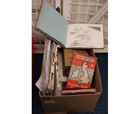
Box of ephemera for Major General F.D.G Howell Second Battalion Grenadier Guards and family to include; letters and other ephemera including the various dart games and how to play them, Lake District Penguin guides, Royal Automobile official touring club map of England and Wales etc. (B.P. 21% + VAT) A few private letters, sketch and autograph books, games (Jo Hand) book Pageantry of Welsh history booklet 'The Story of Squeak' maps, letter regarding his 'Order of the Bath', book of Coronation orders 1937. Photocopies of his military career, London Gazette etc. Playing cards etc.


Lot 112
FOREIGN TRAVEL: CLARKE, Edward Daniel: Travels in various countries of Europe Asia & Africa: 1- Part the first- Russia, Tartary & Turkey. 1811, 4to. complete with all 48 Maps & plates; 1- Part the second- Greece, Egypt & the Holy Land. 1816, 4to. complete with 28 Maps & plates Plus 27 vignettes. Both vols. cover detached and lacking spine; offsetting; An Account of Portugal as it appeared in 1766 to Dumouriez; since a Celebrated General in the French Army. L, C Law, 1797. 274pp; Paper backed cont. marbled boards; rubbed & dusty; China: Its Costume, Arts, Manufactures. Vols. 3 & 4 only of 4; bound in one.1813. with 39 Hand colour plates; which have been almost over cleaned; Barrington, George: Voyage to New South Wales.. c1802; LACKING TITLE PAGE, starts with page 2. Folding map + 10 Hand coloured plates (9 views); lacking covers; Townsend: Journey through Spain in the years 1786 &87; VOL. 3 ONLY.1791. with 3 plates. (6)

Lot 120
COTSWOLD: 1- Crawford, OGS: The Long Barrows of the Cotswolds. 1925, 1st. Maps, plates & ill.; 2- Bowers & Clough: Researches into the history of the parish & church of Stone, Staff. 1929, subscribers’ edition; 3- Daubeny, U: Ancient Cotswold churches. nd (1921), Limited edition No. 368, and SIGNED by author; 4- Witts, G B: Archaeological handbook of the county of Gloucester. Text volume Plus Map volume, plus an extra map volume. nd, c1883. PLUS 3 other Gloucestershire books. (9)

Lot 129
TRAVEL: 1- MacFarlane, C: Our Indian Empire, 2 Vols bound in 1. C. Knight, 1844. with 42 plates (as called for), plus 2 extra plates and only one title page; no map called for. Cont. full calf school prize binding; little rubbed; 2- Picturesque Europe; only volumes: 2(British Isles) & 1+2 of the continent. Cassell, nd, c 1880. Original full leather; rubbed; 3- Nansen, F: Farthest North, 2 vols. Newnes, 1898, 1st. edn. With Map and plates. Original pictorial cloth; damp soiling to cover of vol.1; hinges cracked; map torn on fold; 4- Reclus, E: A New Physical Geography, 2 vols. Virtue, 1886. 4to. original pictorial cloth; 5- Musees, Eglises et Collections de Rome. no date, c1837. A collection of plates loosely inserted in a later folder. A/F; Plus one other. (10)

Lot 148
Mountaineering: Herzog, Maurice, & Marcel Ichac: Regards vers L’Annapurna. Paris, B. Arthaud, 1951. An example especially printed for S. E. Le General Shanker Shamsher Jang Bahadur Rana, Ambassador of Nepal. Original wrappers and a double page map loosely inserted; housed in a special made clamshell cloth box; Fine copy; Plus 4 others. (5)

Lot 149
POLAR EXPLORATION: 1- Nares, Capt. Sir G S: Narrative of A Voyage to the Polar Sea During 1875-6 in H.M. Ships 'Alert' and 'Discovery'; in 2 volumes. Sampson, Low.. 1878, 2nd. edn. With 6 Woodbury type photographs, 8 full page illustrations, 2 folding maps plus text illustrations. Later half leather and new endpapers; 2- Greely, A W: International Polar Expedition: Report On The Proceedings Of The United States Expedition To Lady Franklin Bay, Grinnell Land, 2 vols. Washington, Government Printing Office, 1888. All Plates, Maps & Charts present. Original ribbed cloth and with the author’s complimentary card pasted to front pastedown; 3- [Ray, P H]: Report of the International Polar Expedition to Point Barrow, Alaska, 1884. Washington, Government Printing Office, 1885. 4to. 695pp. with colour Frontis, folding Map Plus 20 Plates (2 coloured). Original cloth. VG. (5)

Lot 151
1- Turbutt, Gladwyn: A History of Derbyshire, 4 vols. Merton Priory Press, 1999, 1st. Dws. SIGNED by author & letter from publishers confirming the signature. 4to. Fine set; 2- Aikman, J: History of Scotland, in 4 vols. Glasgow, Blackie, 1827. With a folding colour map plus a frontis to each vol. cont half leather; rubbed; 3- Hyde, Patricia & D Harrington: Faversham Oyster Fishery. 2002, Limited edn. #41/425, Signed; 4- Ashby-de-la-Zouch Castle, Leicestershire, 1913, Signed by author; 5- Hyde, Patricia: Thomas Arden in Faversham: The Man Behind the Myth. Signed; 6- Hyde, Patricia & D Harrington: Faversham Tudor and Stuart Muster Rolls. 2000; Signed; 7- House of Parliament, Act of Parliament Ashby-de-la-Zouch Canal Act 1794. Eyre and Strahan, 1794. 8- Winsor, Diana; The Dream of Bath. 1980, 1st, edn. Signed. (14)

Lot 155
ESSEX & HERTS.: 1- Wright, Thomas: The picturesque beauties of GB, ESSEX. Virtue, 1831. 4to. Engraved title page, large folding colour map, 2 full page Plus 45 double view, ONLY OF 47, blank pages inserted instead! Later half leather; 2- [Cromwell, T.K.]: Excursions through Essex. 2 vols. in one, TITLE OF VO.1 in FACSIMILE. Longmans, 1818-19. Folding map & plan (both bound in vol.1). One extra engraved title Plus97 of 100 plates. Errata present in vol.1. Later half leather; 3- A New and Complete History of Essex, 3 vols only. Lionel Hassall. Chelmsford, no date & 1769. Defective. Vol.2 lacking title; many plates are present, but some missing. A/F; 4- CHAUNCY, H: Historical Antiquities of Hertfordshire. 2 vols. Griffin, 1826, 2nd edn. All plates present, But LACKING THE MAP. Cont. half leather, rubbed. Housed in a slipcase. (6, but 7 vols.)
-
109198 item(s)/page