We found 109182 price guide item(s) matching your search

Refine your search

Year

Filter by Price Range
  • List
  • Grid
  • 109182 item(s)
    /page

Lot 426

fidus tibi dux et achates per Belgium. Hispan. Regnum Galliae. Ducat. Sabaudiae, Turinum usq. Pedemonti Metropolis. Leiden, Elsevier, 1631. (8),671,(1),(38) p. 16mo. Vellum, ill. title-p. Travelguide.(2) Q. Curtii Rufi Historiarum libri. Ibid., idem, 1633. (10),338,(20) p. 16mo. Leather, ill. title portrait, fold. map of Alexandri Magni Macedonis expeditio and full p. engr. (3) Ibid., idem. Limp vellum binding. All copies show much use. (total 3)

Lot 1100

(1) Tabula Bergarum ad Zomam Stenbergae et novorum ibi operum. Amst., Joannes Janssonius, ca. 1650. 23 x 54 cm. Tear outside the map image.(2) Bergen op Zom, fortification plan by G.G. Priorato. Frankfurt, 1683. 31.5 x 39.5 cm. (3-5) Double-lvs. taken from Joan Blaeu's "Stedenboek". Amst., 1649. 40 x 53 cm. W. fortifications of a.o. Steenbergen, Lillo, and Ordam. (6) Nieuwe kaart van de Baronie van Breda en 't Markgraafschap van Bergen op Zoom. Amst., Isaak Tirion, ca. 1740. 28 x 32.5 cm. (7) and (8) 2 more of the same but printed on silk (rare). -and 2 others. Sold w.a.f., not subject to return. (total 10).

Lot 1167

Canada, British Columbia and Northern Mexico showing all the Railroads, Counties and Principal Towns up to date. Constructed from the latest Government and Railroad surveys. Chicago, Rand McNally and Co, 1889. Reissued by De Financier. Wekelijkse Beurscourant. Groningen. Ca. 1900. Map image 96 x 136 cm. Col. steel engr. w. Statue of Liberty and title in left and right below, respectively. Folded, thin paper, some paper loss along the folds; shabby copy.

Lot 1090

Contenant 50 (= 48, complete) nouvelles cartes geographiques, des Païs Bas Espagnols, Provinces-Unies, haute et basse Allemagne, les Electorats & Principautez du Rhin, haute et basse Alsace, La Lorraine; Bourgogne, Suisse, Savoye & Piemont, avec une grande partie de la France, de l'Italie, & autres Païs adjacents, où l'on fait à present la guerre. Ouvrage très utile aux officiers et voyageurs (...). Engr. title: Le Théâtre de Mars contenant XLVIII nouvelles cartes (...). Amst., A. Braakman and P. Schenk, 1708 (engr. title: 1706). Narrow 4to. Later marbled calf w. gilt borders around sides, gilt spine w. mor. letterpiece, a.e.g., double-p. letterpress title printed in red and black, introd. in French and Dutch (both 2 p.) and 28 p. index, w. the following double-p. contemp. handcol. engr.: title; general map (numb. 1); and 47 maps (numb. 2-48).Top of spine frayed and mild damage to binding, a few maps cut sl. short (affecting numbers in borders), final index leaf waterst. in lower margin, occas. other minor stains. An attractively bound, beautifully col. copy of a very rare pocket-atlas. Koeman Brn 3.

Lot 1146

with Part of Agra and Delhi exhibiting the Course of the Ganges from Hurdwar to the Sea. Surveyed by James Rennell. London, for William Faden, 1786. 72 x 54 cm. Large engr. fold. map of northern India on 2 sheets (8 segments), linen-backed, slipcase (37.5 x 32.5 cm), orig. handcol., large ill. cartouche w. French title.

Lot 943

naar officieele bronnen bewerkt. Leeuwarden, Hugo Suringar, 1865-69. Obl. 4to. New binding, hleather, spine w. gilt title, new endpapers, title w. vignette, fold. map of N. Brabant, 180 maps outlined in col.Title w. sm. part cut out, otherwise a nice copy w. all N. Brabant maps, all in excellent condition.

Lot 1185

Manuscript map, irregularly shaped fold. leaf of 60 x 90 cm., depicting the section to the right of the railway station, including the Koornmarkt, Oeverstraat, Lange Straat, Stads Tuinen and the bend of the Rhine at the right, on laid paper with watermark C. and I. Honig, second half 19th cent.Folds; some tears and sm. (closed) holes, with a number of repairs and strengthening with tape. (2-5) "Uittreksel uit het kadastrale plan Gemeente Arnhem. Sectie Q./ Arnhem Sectie D/ Velp Sectie C". Four manuscript maps, all w. sheet size of ca 70 x 100 cm, dated 1892, numbered "Nr. 1" to "Nr. 4", all stamped "K 73" in lower right corner and all with ticket "Maatschappij tot Exploitatie van Staatsspoorwegen. Brug over den IJssel bij Westervoort" and "Archief No. 3.1" to "3.4 " verso. All folded, w. margins strengthened and/ or tears closed w. tape. The first map lacks a portion of upper left corner. All with manuscript "Vergeleken met het kadastrale plan de ambtenaar voor de boekhouding" [signed) and "Afgegeeven door mij Bewaarder van de hypotheken en het kadaster te Arnhem den 7/ 9 Mei 1892" (signed). And 4 similar manuscript maps in the same large size and with all the same characteristics, of Westervoort (3x) and Duiven. (total 9)

Lot 1120

door Davidt Fabricio van Esentz soe wel voor water als te lande neerstelijck beschreven. Nova descriptio orientalis et occidentalis Frisiae (...). Map taken from: Germania inferior id est, provinciarum ejus novae et exactae tabulae geographicae. Amst., 1617. 38 x 49 cm. Signed in the plate by Kaerius.Leaf numb. 79 w. Latin text, professionally restored map. Beautifully col.

Lot 49

Map of the city of Makassar in Indonesia "Samboupo". Jakob van der Schley and Jacques Nicolas Bellin, 18th century. Copper engraving. Presents stains of humidity and dirt. Wrinkles and folds. Presents some lack on the sides. Measurements: 21 x 36 cm (print); 25,50 x 40 cm (paper).

Lot 421

A group of 15 prints and pictures comprising a reproduction antiquarian map of the County of Worcester; a large contemporary abstract print in blue and red and one other similar print; 'Beach Rocks', a photograph printed on canvas; two framed pictures of a ceremonial dinner; four Joanne Boon Thomas prints of figures, two prints after Arthur Rackham, etc (15)At present, there is no condition report prepared for this lot, this in no way indicates a good condition, please contact the saleroom for a full condition report

Lot 50

A vacuum-formed map of Wales prepared by the Cartographic Department of the Clarendon Press, Oxford in association with Barclays Bank, 98.5cm x 69cm including its wooden frameMarks and wear overall

Lot 1044

A Campana shaped wine cooler, unframed map and unframed print

Lot 1294

A MAP Size L waterproof jacket

Lot 767

An un-framed map Dow cave and a frameless bevel edge mirror

Lot 524

MAPS, one box containing over 100 Ordnance Survey maps (some duplicates) and others and a Baedekers AA map of Germany (1 box)

Lot 529

TWO BOXES OF OVER ONE HUNDRED MAPS, to include Ordnance Survey, Batholomew's map, National Grid, AA, etc (2 boxes)

Lot 454

A map of South America laid on canvas, 97cm wide

Lot 751

Guillaume de L'Isle, coloured engraving, 'Carte du Royaume de Danemarc' framed map, 1730 by Jean Covens et Corneille Mortier, 49 x 61cm

Lot 285

An Isle of Man Advertising Poster Jubilee Map after William Hoggatt, RI, RBC, 120cm x 96cm approx

Lot 46

The Legend Of Zelda A Link To The Past SNES boxed, game cartridge comes boxed with a fair looking instruction booklet, hyrule map and inner box, box itself is in good condition, has few tears, creases and price sticker damage to front, cartridge is in good untested condition could use a clean.

Lot 4113

T Haynor (British 18th century): Plan of Whitby with Shipping Instructions, engraved map with hand colouring 37cm x 62cm

Lot 160

Antique map of Knapdail - Knapdalia Provincia by Timothy Pont and Joan Blaeu published 1654 [51x61cm]

Lot 112

An interesting ancient map of Jedburgh and the environs, pen, pencil and wash, in sections and framed together, 92cm x 67cm; together with a modern map of Roxburghshire and six assorted pictures (8)

Lot 237

A pair of modern ‘Replogle’ World Map Series 12 inch terrestrial globes, on library stands, 100cm high

Lot 318

Thomas Martyn (1735-1825) - Coloured engraving - "A New and Accurate Map of the County of Cornwall", 21ins x 28ins, and Emanuel Bowen (1693-1767) - Coloured engraving - "An Improved Map of Wiltshire, Divided into its Hundreds", 21ins x 29ins, both framed and glazed

Lot 1045

After Samuel Howitt - two sporting prints; 19th century school monochrome landscape watercolour; George III later hand-coloured print of the Essex Cavalry; and after Robert Morden engraved county map of Essex with hand-coloured hundreds (5)

Lot 567

Browning, Robert; The Pied Piper of Hamelin, illustrated by Van Dyck, together with a Victorian Picture BIble, bound in half red morocco, an Edwardian postcard album, the contents mainly being British topographical, a George VI Coronation volume, Coronation Map and Guide to the Heart of London and a The Popular stamp album. (6)

Lot 762

A framed and glazed map of Surrey. 79.5 x 67.5 cm overall.

Lot 196

A 19th century engraved map of Essex, later hand coloured, 39 x 49cm, framed, together with another 19th century map, by Eman Bowen, to Benjamin Mildmay (2)Both appear to be removed from a book, as they have the join down the centre. Later hand coloured and framed. Light discolouration to the paper. Paper not completely flat.

Lot 242

A 19th century hand coloured engraved map of England and Wales, 35 x 35cm, together with three maps of Essex, another of Kent, an engraving of Eastbury House, Essex, and an antique road map to include Sudbury, Lavenham, Braintree (7)

Lot 56

Selection of leather bound map holders, drink holders, Military tape measure etc

Lot 613

A British Railways Nottingham Victoria Train Departures poster (a/f) and a map of The London Midland and Scottish Railway and Connections

Lot 701

A collection of Nottingham related books, a framed map of Nottingham and two framed photographs of old Nottingham

Lot 677

Marinemalerei 19. Jahrhundert, Flaggen Karte, marine painting 19th century flag map,Aquarell/Papier, H 37 cm x B 46,5 cm, Holzrahmen verglast 41,5 x 51,5 cm, Schmutzstellen

Lot 1075

A framed map of The Royal Viking Sun 22" x 18".

Lot 1115

A mid Victorian survey framed Map of land acquisitions for Barnsley Station, plus a small glazed framed ship with sails.

Lot 1152

An old framed and mounted Map of Herefordshire "Herefordia", 25 1/2" x 21" including frame.

Lot 5657

Large teak framed military style map tableDimensions: Height: 52cm  Length/Width: 135cm  Depth/Diameter: 89cm

Lot 212

Only Fools & Horses - an original BBC issued Recording Ticket for the 2001-2003 Christmas Special episodes. The ticket features the Only Fools logo to the front, and a small map to the rear. Signed to the front by Sir David Jason in black ink. Supplied with a COA from the Only Fools and Horses Appreciation Society. 9cm x 13cm. 

Lot 294

SIX 18TH-19TH CENTURY PRINTED AND COLOURED MAPS OF CHINA. Comprising four coloured copperplate maps by J. N. Bellin, circa 1764, CARTE, DE L'ISLE DE CHEU CHAN OU ISLE DE CHUSAN De la Province de Che-kiang Avec les Costes et Isles voisines, 220 by 320mm (8.75 by 12.5 inches), ISLE DE CHEU CHAN OU ISLE CHUSAN avec les Costes et Isles voisines, 220 by 170mm (8.75 by 6.75 inches), CARTE DES ISLES QUI SONT A L'ENTREE DE LA RIVIERE DE CANTON, 220 by 175mm (8.75 by 7 inches) and CARTE DE LA BAYE D'HOCSIEU et des Entrees de la Riviere de Chang, Dans la Province de Fokyen, en Chine, 220 by 170mm (8.75 by 6.75 inches); a map of CHINA by W. Lizars, Edinburgh 1842, 450 by 370mm (17.75 by 14.5 inches) and another map of CHINA by George Phillp & Sons, London, circa 1859, coloured lithograph, 595 by 520mm (23.5 by 20.5 inches) (6)The first (Bellin, Isle de Chusan…) This detailed chart is orientated with north to the right, and shows Ning-po (Ningbo) at top with area east below it, in the province of Chekiang, across the bay from Shanghai. From an edition of Prevost's 'Histoire des Voyages'. Good Condition. The second (Bellin, Isle de Cheu Chan ou Isle Chusan…) Detailed chart of the area east of Ningpo (Ningbo) in the Chinese province of Chekiang, located across the bay from Shanghai. This chart is from the original edition appearing in 'Le Petit Atlas Maritime' and has attractive original hand wash colour. The third (Bellin, CARTE DES ISLES QUI SONT A L'ENTREE DE LA RIVIERE DE CANTON) An attractive and detailed chart, orientated with north to the left, showing the islands at the mouth of the Canton River and Latao and extending past Macao to 'Chang-chuen-chan ou isle de Sancian'. This small chart appeared in the five volume 'Petit Atlas Maritime' of the renowned French hydrographer, Jacques Nicolas Bellin. The fourth (Bellin, Carte de la Baye d’Hocsieu) This chart for the original edition of "Le Petit Atlas Maritime" shows the mouth of the Chiang River in the Fujian Province of modern day China. It covers part of the modern-day city of Fuzhou on the south eastern coast of China just west of Taiwan or Formosa. Very detailed, it also features towns, fortifications, islands, bridges, rivers and mountains. Depth soundings around the coastline are also marked.The fifth (Lazars 'CHINA') With attractive outline colour. This detailed map of China includes text giving measurements of 'The Great Chinese Wall' amongst other notations. Korea and Formosa or 'Taiouan' are shown in some detail. the map appeared in 'Lizars' Edinburgh Geographical General Atlas: Containing Maps of Every Empire, State, and Kingdom;...' The sixth (G Phillips & Sons, ‘CHINA’), This interesting map of China was published in "The Philips New General Atlas". In the bottom left corner is a list of useful Chinese terms, translated into English. Postage stamp-size insets show outline detail of the important ports of Chusan, Amoy and Hong Kong. The map is surrounded by a distinctive and decorative piano-key border.

Lot 295

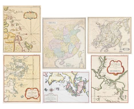
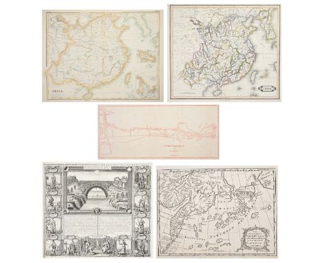
FIVE 18TH-19TH CENTURY PRINTED MAPS OF CHINA. Comprising: an example by H. A. Chatelain, HABILLEMENS D'HOMMES & DE FEMMES DIVERSE PROVINCES DE LA CHINE, Amsterdam circa 1720, Copperplate uncoloured, 370 by 430mm (14.5 by 17 inches), a map by T. Bowen, London 1775, THE NORTHERN ARCHIPELAGO ... IN THE SEAS OF KAMCHATKA..., Copperplate uncoloured, 170 by 235mm (6.75 by 9.25 inches), a map by Lizars CHINA, Edinburgh circa 1842, steel plate, original outline colour, 395 by 445mm (15-5 by 17.5 inches), a map of CHINA by G. H. Swanston & J. Bartholomew, Edinburgh, London & Dublin, A Fullarton & Co. circa 1860, coloured steel plate, 412 by 535mm (16.25 by 21 inches), and a map by W. F. Mayers, London / Hong Kong 1867, FROM TUNGCHOW TO PEKING, uncoloured Lithograph, 180 by 410mm (7 by 16.25 inches) (5)The first (Chatelain, Habillemens D’Hommes & De Femmes Diverse….) Finely engraved. A decorative and elaborate plate from Henri Abraham Chatelain's 'Atlas Historique' illustrating and describing Chinese people of all ranks and regions. Also displayed is a Jesuit Priest and the monumental bridge connecting two mountains in Xensi province.The second (Bowen, The Northern Archipelago…) Engraved by Thomas Bowen and published in the 'London Magazine', this map purports to illustrate the recent Russian discoveries in the northeast Pacific, showing the Aleutian Islands and a large 'Alaschka Island' off the mainland of North America. Trimmed close and laid on old paper. Jolly, Maps in British Periodicals I, LOND-306.The third (Lizar, China) An attractive and detailed map of China, including Korea, Taiwan and Hainan. Original outline colour delineates the districts. A note on the 'Chinese Wall' appears at the upper left, noting that it is 'so broad, that 5 or 6 Horsemen may travel abreast on the top'.The fourth (Swanston & Bartholomew, China) An attractive and detailed map of all China with inset details of Chusan and the estuary of the Canton River from Canton to Macao and Hong Kong.The fifth (Mayers, From Tungchow to Peking) William Frederick Mayers was one of a number of British Consular officials active in the major ports and towns in the Far East during the mid-nineteenth century. His work "Treaty Ports Of China and Japan" was a source of much valuable information for visitors whether in the pursuit of trade or as tourists, and included detailed folding maps of many of those trading ports featured. Published in London and Hong Kong. This map shows in good detail the road from the town of Tungchow to Peking's outskirts, approximately 14 miles with remarks as to the road surfaces, ie whether 'Stone Paved' or not. Printed in light scarlet ink on thin rice paper with backing to old fold weakness.

Lot 1001

A wooden framed Ely ordnance survey map from Somersham railway station

Lot 1185

A vintage framed map of Penang Island, 68cm x 56cm.

Lot 470

A double sided Mediterranean Series AAF silk map, compiled for the U.S Army Air Forces

Lot 879

Kelly, Christopher - 'A Full Circumstantial Account of the Memorable Battle of Waterloo - The Second Resoration of Louis XVIII and the deportation of Napoleon Bonaparte', Printed for Thomas Kelly London 1817.With various engravings and fold out map.

Lot 187

The Handy Royal Atlas 1873 by A Keith Johnston, half-leather binding (a/f), Van Den Wyngaerde (Anthonis) The Panorama of London circa 1544, London Topographical Society, 1996, hardback, Skelton (R.A.) Saxton's Survey of England and Wales with a facsimile of Saxton's wall-map of 1583, Nico Israel, 1974, hardback, 2 18th century pages on Whitby and Scarborough with plate of Towns to pages, & a collection of reproduction maps of Wales, Ireland, Scotland and England, etc

Lot 375

Ten Ordnance survey air maps (second war revision 1943), coloured Air Ministry maps, scale 1/4" to 1 mile, including 1/50,000 colour scale map depicting military training zones around Western Germany and Eastern Belgium c.2013 132cm x 109cm (10)

Lot 122

An Early Coloured Map Of Carnarvonshire 37 x 49 cms

Lot 652

ASSORTED SECOND WORLD WAR BRITISH KIT & EQUIPMENT comprising a brass Telescope Sighting No.22C Mk II, dated 1943; a copper and brass bugle, by Henry Keat & Sons, London, dated 1941; a webbing back pack, by Mattinson Bros., dated 1940; a webbing map case, dated 1942; and a service issue gas mask (undated), in a canvas bag dated 1941, (5).

Lot 179

A quantity of RAF ephemera - including aircraft recognition posters from the Pacific campaign, various exploded drawings to aircraft and engines, aeronautical charts of the UK and Europe, air raid precautions, and a silk 'escape' map for Burma (south).

Lot 671

JOHANNES BLAUE (1596-1673) Map of Brittany, later copy Framed and glazed Picture size 38 x 52cm Overall size 51 x 66cm Together with a map of Paris Framed and glazed Picture size 37 x 48cm Overall size 53 x 62cm

Lot 107

STAINED WOOD NEST OF THREE TABLES,each top inset a map, the largest 63.5cm wide

Lot 337

MAP BY JOHANNES BLAEU,hand coloured, titled 'Evsdail et Eskdail', framed and under glass, 55cm x 65cm

Lot 428

EARLY 19TH CENTURY MAP OF SOUTHERN SCOTLAND,by J. Cary and published J. Stockdale, the plate 38cm x 52cm, mounted, framed and under glassVisable fold marks and creases to the map, other than that the rest is in good condition with no other visable damages.

Lot 3223

Altkolorierter Kupferstich, erschienen bei Homann Erben, Nürnberg, in der Platte dat. 1756. Überaus detailreiche Karte der Balearischen Inseln mit Mallorca, Ibiza, Menorca, Formentera und Cabrera. Die eine Insetkarte zeigt die Stadt von Mahón (Maó) mit der Festung, die andere die Lage der Balearen im Mittelmeer. Ca. 42 cm x 47,5 cm (Passepartoutausschnitt). Rahmen.A hand-coloured copper engraving with a map of the Balearic Islands and Mahón published by Homann heirs in Nuremberg 1756.

Lot 3228

und dem Amt Neuen Gleichen". OriginaltitelKupferstich/Papier, gestochen von Conrad Felsing aus Helfrich Bernhard Wencks Hessischer Landesgeschichte, in der Platte dat. 1783. Detailreiche Karte mit ausführlicher Betitelung l. o., darunter 3 Wappen der Herren zu Plesse sowie l. u. mit Legende. Darstellung 40,8 cm x 56,5 cm. Rahmen. A copper engraved map of the domain of Plesse by Conrad Felsing.

Lot 176

Dighton (Robert), After. Geography Bewitched! or, a Droll Caricature Map of Ireland, "This portrait of Lady Hibernia Bull is humbly dedicated to her husband the great Mr. John Bull", etching, on cream wove paper without watermark, sheet 210 x 160 mm (8 1/4 x 6 1/4 in), tipped at edges into old window mount with verso visible, faint pencil inscription '1786' in the lower right, [BM Satires 8399], Bowles & Carver, circa 1780 [but probably circa 1830]

Lot 181

America.- Native Americans.- A Narrative of Occurrencies in the Indian Countries of North America, first edition, engraved folding hand-coloured map (with small closed tear at edge, paper repair to verso, light off-setting), p.iii small manuscript ink inscription, title with light finger-soiling, original printed wrappers, rebacked with cloth, some soiling, [Sabin 20699, ascribed to T. Douglas], 8vo, B. McMillan, 1817.⁂ Rare with map. Full title continues, "since the connexion of the Right Hon. the Earl of Selkirk with the Hudson's Bay Company, and his attempt to establish a colony on the Red River; with a detailed account of His Lordship's military expedition to, and subsequent proceedings at Fort William, in Upper Canada". This work bears testimony to the feud between the Hudson Bay Company and the North West Company of Montreal, which was brought to a close by their unification in 1821. It is also important for the development of Manitoba province. Authorship attributed to several individuals: Thomas Douglas; E. Ellice (as per ink inscription in this copy); Simon McGillivray and Samuel Hull Wilcocke.

Lot 182

America.- Solinus (Caius Julius) Polyhistor, Rerum Toto Orbe Memorabilium Thesaurus Locupletissimus, edited by Sebastian Münster, 2 parts in 1, woodcut printer's device to title and final verso, 2 folding woodcut maps, 18 woodcut maps or topographical views in text (2 full-page), book label mounted on title (obscuring ink ownership inscription), 1 map browned, with small tear at foot of fold and small hole to margin, some splitting to gutters (see C1 in particular), several ff. browned, some light marginal browning and damp-staining, hinges cracked, contemporary vellum, morocco label to spine, spine repaired at head and with a little worming, [Adams S1394; Burden 11; VD16 S 6969], folio, Basel, Michael Isingrin, 1543.⁂Second edition of Sebastian Münster's annotated commentary of Solinus' and Mela's geographical texts. The map of 'Asia Maior' includes 'The earliest representation of the North-West coast of America on a printed map' (Burden).

Lot 195

Switzerland.- [Lory (Gabriel)] Picturesque Tour through the Oberland in the Canton of Berne in Switzerland, hand-coloured engraved map and 17 fine hand-coloured aquatint plates, bookplates of George Veitch and Michael Matantos, title with small mark in red pen, affecting one letter, short closed tear to head, not affecting text, some very light spotting and offsetting, modern half green morocco, gilt, uncut, spine slightly sunned, [Abbey, Travel 57; Tooley 26], small folio, R. Ackermann, 1823.⁂ Including an account of the first ascent of the Jungfrau and Finsteraarhorn by the Meyer brothers in 1812 (p.60).

Loading...Loading...
  • 109182 item(s)
    /page

Recently Viewed Lots