

THE CHARLES DORAN ARCHIVE A collection of Papers, Surveys, Reports, Photographs associated with the talented and versatile Charles Guilfoyle Doran (1835-1909)“Charlie” Doran began his career as a plasterer in Dublin, and “through diligence and study” succeeded in qualifying as an architect and engineer. For most of his life he was actively involved in the Fenian movement; after the failure of the 1867 rising he escaped to France, and on his return to Ireland lived at Dunworth House, Queenstown (Cobh). He was Clerk of Works during the building of St Colman’s Cathedral, and contributed to several public water schemes in Co. Cork. From 1883 he was one of the Queenstown Town Commissioners. He was also a keen member of the Cork Historical and Archaeological Society, contributing several papers to its journal, and assembled a fine private library. The Archive comprising the following items, from aspects of Doran’s Life:· Scrapbook: “The Irish Agrarian Rebellion 1880-1881.” Contains news cutting from the Illustrated London News, Graphic etc. with reports on parliamentary debates, full-page illustrations, caricatures. A graphic record of this troubled and contentious period in Irish history. Hardback (disbound), 45 x 31 cm. . “Map of Paris with the latest improvements 1855.” Compiled as a record of Queen Victoria’s visit to Paris in August of that year (there are illustrations of her reception by Napoleon III on the back). Cloth backed; fragile. 70 x 55 cm. .An extensive and diverse Archive of an Industrious and Patriotic Irish Figure from the late 19th Century. As an Archive, w.a.f. (1)
We found 109182 price guide item(s) matching your search
There are 109182 lots that match your search criteria. Subscribe now to get instant access to the full price guide service.
Click here to subscribe- List
- Grid
-
109182 item(s)/page


Maps: Kitchen (T.) A collection of five folding miniature Maps, including: * A New and Accurate Map of Hispaniola, St. Domingo Puerto Rico; * A New and Accurate Map of the Island of Cuba; * An Accurate Map of the Island of Martinico; * A New and Correct map of the West Indies; * A Correct Map of the Island of Jamaica; all c. 1740's, as a collection, w.a.f. (5)


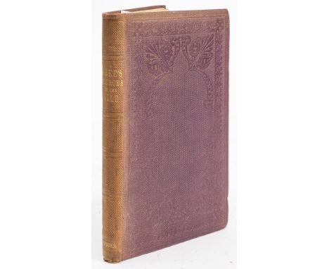
![[Tighe (William)] Statistical Observations Relative to the County of Kilkenny, Thick 8vo D. 1802. First Edn., lg. h](https://cdn.globalauctionplatform.com/6e4c89b0-9e21-45b6-97ed-ade100bf2b2d/d045cf9f-2613-4ca6-a8ac-adf00099296a/468x382.jpg)
[Tighe (William)] Statistical Observations Relative to the County of Kilkenny, Thick 8vo D. 1802. First Edn., lg. hd. cold. fold. map, & all the plts. & tables as per list, uncut in later hf. calf, binding, profusely gilt spine in panels, mor. labels. Good copy. (1) * One of the earliest and best of the Royal Dublin Society's Surveys.


Smith (Charles) The Ancient and Present State of the County of Kerry, 8vo Dublin (For the Author) n.d. [c. 1756-1774] First Edn. engd. port. frontis, vignette title, lg. fold. map of Co. Kerry, fold. Plan of Tralee & 4 engd. plts. (mostly fold.) cont. calf, with armorials of Signet Library. (1) * The rarest of all Smith's County Histories.


Unique Copy with a Profusion of Extra Manuscript Notes Smith (Charles) The Ancient and Present of the County and City of Cork, 2 vols. 8vo D. 1750. First Edn., Engd. port. frontis Vol. I, list of subscribers, lg. fold. map of the County, & 12 engd. pls. some lg. fold.) complete, annotated by a contemporary hand thro-out, & with extra notes, cont. calf, raised bands, mor. labels. V. good. (2) * A most interesting copy, with considerable additions, local observations and corrections from the Collections of John Lodge Esq. & others. Together with the numerous annotations and comments in the margins, there are also 55 tipped in manuscript notes (some full page) thro-out the text, plus 2 extra engd. plates. A unique and highly important copy.

Map: Cary (John) Map of the British Isles; Comprehending the Whole of the Turnpike Roads... Navigable Canals... From the most Recent Surveys. Reduction of his Six Sheet Map. Lg. fold. linen backed map, fully hand-coloured, approx. 39" x 50" (99cms x 127cms), London 1824. In orig. slipcase, with ptd. label. V. good. (1)


Cornerstone of Any Irish Historical Collection O'Donovan (John, ed) Annala Rioghachta Eireann - Annals fo the Kingdom of ireland by the Four Masters. From the earliest times to the year 1616. De Burca 1998, 7 vols. large quarto green buckram gilt in orig. slipcase, with De Boazio's Map of Ireland in en-suite folder. Third and best edition, with the missing years of the original (1334-1416) supplied from Roderic O'Flaherty's transcript. With a new intro. by Kenneth Nicholls. Fine set, a cornerstone of any Irish historical collection. O'Donovan's enormous scholarship, breath-taking in its extent when one considers the state of historical scholarship and the almost total lack of published source material in his day, still amazes one' (Nicholls). (7)


ROSS, John - A Voyage of Discovery, made under the orders of the Admiralty, in His Majesty's Ships Isabella and Alexander, for the purpose of Passage : large folding frontispiece map, large folding panoramic plate, 2 maps, 6 plates and tables with the appendix,19 mainly hand coloured aquatints occasional spotting and offsetting, paper covered boards with printed paper title-label on the spine.

CONYBEARE, W.D & PHILLIPS, William - Outlines of the Geology of England and Wales : Part One (all published) folding hand coloured geology map of England and Wales, one large folding hand coloured panoramic plate, half calf hinges cracked, 8vo, 1822. With -three others geology inc. an odd volume of Lyell's Principles.(4)


ROSS, Sir John - Narrative of a Second Voyage in search of North West Passage, and of a residence in the Arctic Regions during the years 1829, 1830, 1831, 1832, 1833. Large folding colour map badly folded and repaired on verso, with 29 other plates and charts inc. hand coloured. cont. half morocco rubbed.4to, a degree of foxing throughout, A.W. Webster, 1835.


BIBLE : The Holy Bible, Containing the Old Testament and the New - prayers, psalms; genealogies (34); double page map, OT 1 - 718 lacks seven pages; Apocrypha lacking two leaves, NT 721 - 904; concordance; prayers; psalms 1 - 90; (viii) lacks after last leaf, several pages torn with loss, old calf hideously repaired, 4to, 1634.* sold with all faults not subject to return

TOWNSEND, Thomas - The History of the Conquest of Mexico by the Spaniards. Done into English from the Original Spanish of Don Antonio De Solis : Engraved portrait frontispiece, 6 folding plates, folding map, map. Calf pulling at the head of the spine. Folio, Printed for T. Woodward, London, 1724.


![JANSSON, Jan - Cornubia.[Cornwall] : hand coloured map, size 490 x 370mm, F&G, some age discolouration.,c1646.](https://cdn.globalauctionplatform.com/16427ae3-b6dd-4c32-a92c-add60137c3ca/7af2dccb-0818-40f4-b190-add700d3f4cc/468x382.jpg)
![MERCATOR, Gerard - [West Country and Wales] hand coloured map, size : 465 x 370 mm, f&g, n.d. With - Morden, Robert, Britanni](https://cdn.globalauctionplatform.com/16427ae3-b6dd-4c32-a92c-add60137c3ca/b95c06ed-60a5-434f-a0b8-add700d40225/468x382.jpg)


COLERIDGE, H. N - Six Months in the West Indies, in 1825 : half calf, 8vo, John Murray, 1826. With - Southey, Robert, The Expedition of Orsua; and the Crimes of Aguirre, org. cloth paper label, small 8vo, 1821. With - Buxton, George F, Adventures in Mexico and the Rocky Mountains, half calf, small 4to, John Murray, 1847. With - Brown, James B, Views of Canada and the Colonists, large folding map, org. cloth, chipped head of the spine, 8vo, 1851.(4)


MOLL, Herman - A New Description of England and Wales: 44 ex. county maps, half calf worn oblong folio, lacks all before the map of Cornwall which is heavily soiled and repaired in margin, small stain to the corner of the three west country maps, heavier stain to Cumberland. West Riding trimmed in outer margin with loss of the border of antiquities, a very light stain to most others just appears as a light discolouration, c1724. *Herman Moll uniquely devised his set of maps to have 'local' antiquities engraved in their margins. * Sold with all faults not subject to return

FADEN, William - A New Pocket Plan of the Cities of London & Westminster : with the Borough of Southwark : Comprehending the New Buildings and other Alterations to the year 1790 - large folding map mounted on linen dissecting in 20 sections in original marbled slipcase. Size : 885 x 435 mm. Very good condition. * extends from Hyde Park in the West to Stepney in the East; and Islington in the North to Newington in the South.
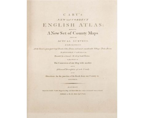
CARY, John - Cary's New and Correct English Atlas: being a New Set of County Maps - advert lf, eng. title-page, eng. dedication lf, (viii), general map, 2 maps (Wales),55 county maps with original outline hand colouring, half calf boards detached, advert if torn, all maps in very good condition except for Dorset which has a splash mark, 4to, first edition,1787.


HAKLUYT, Richard - The Principal Navigations, Voyages, Traffiques and Discoveries of the English Nation, made by sea or over-land, to the remote and farthest distant quarters of the Earth: ... (etc) 3 volumes bound in two,the final volume is entirely dedicated to the Americas, folding MAP OF THE WORLD (which is often missing) is in a delicate state but appears complete. Quite a number of pages are mis-numbered but still collates complete. The suppressed pages on the conquest of Cadiz pp. 607-619 ARE PRESENT Contemporary calf raised band, missing one morocco label. Folio. George Bishop, Ralph Newberie, and Robert Barker, second edition, 1599-1600.

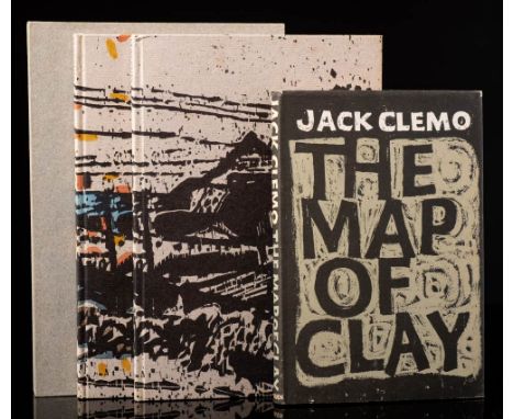
CLEMO, Jack - The Map of Clay : cloth in complete d/w, 8vo, Methuen, first ed. 1961. * a typed and signed note by Clemo loosely inserted refers to the introduction by Charles Causley being not accurate as with the encouragement of a lady friend with whom he spent his holiday with, has encouraged him to learn Braille. With - Clay Cuts, woodcuts by Stan Dobbin, org. decorated boards in slipcase, 8vo, The Previous Parrot Press, limited to 186 copies, this being one of the 38 that have been hand-coloured, signed by the author and the woodcut artist. 1991. With another copy uncoloured.(3)


WORDSWORTH, William - A Guide Through the District of the Lakes in the North of England : Folding frontispiece map, half morocco, small 8vo, Hudson & Nicholson, Kendal, fifth edition, 1835. With - A Complete Guide to the Lakes (etc), folding map at the rear, steel eng. frontis. 4 sketch maps, 2 circular maps, morocco, 8vo, Kendal, fourth edition, 1853. With - Otley, Jonathan, A Concise Description of the English Lakes, folding map, cloth paper title label on the spine, 8vo, Published by the Author, Keswick, fifth edition, 1834. With one other.(4)

MOLTKE, Baron von - The Russians in Bulgaria and Rumelia in 1828 and 1829 : Folding general map, 12 plans inc. folding, org. red cloth short tear at the head of the spine, 8vo, John Murray, 1854. With - Bell, Major Evans, The Mysore Reversion, "An Exceptional Case": org. green cloth, 8vo, Trubner, 1866. With - Holdsworth, A. H, Campaign of the Indus : in a series of letters from an officer of the Bombay Division, org. cloth, 8vo, 1840. With - Muller, Max, The Languages of the Seat of the War in the East. With a Survey of the Three Families of Language : org. cloth split on one hinge, 8vo, Williams & Norgate, 1855. ALs stuck to front end paper. With - Robertson, Sir George S, Chitral the story of a minor siege : large folding map, 4 plans, plates, org. cloth sunning to spine, 8vo, Methuen, 1899. With two others.(7)


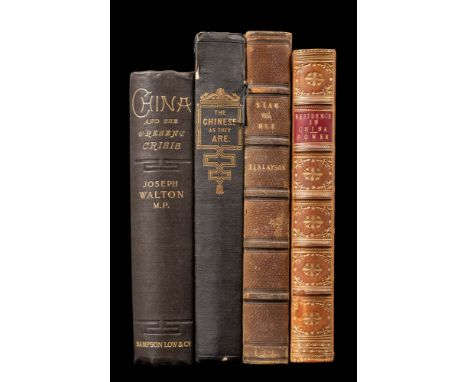
POWER, W. Tyrone - Recollections of a Three Years' Residence in China ; including Peregrinations in Spain, Morocco, Egypt, India, Australia, and New Zealand : colour printed title-page, half calf hinge just starting, 8vo, Richard Bentley, 1853. With - Finlayson, George, The Mission to Siam, and Hue the Capital of Cochin China, in the years 1821-2, eng. frontis, half morocco, 8vo, John Murray, 1826. With - Lay, G. Tradescant : The Chinese As They Are: their moral, social, and literary character ... illustrated, org. cloth torn on the hinges, 8vo, William Ball, 1841. With - Walton, Joseph, China and the Present Crisis with notes on a visit to Japan and Korea : large folding map (slightly carelessly folded) org. cloth, 8vo, Sampson Low, Marston, first edit, 1900 (4).

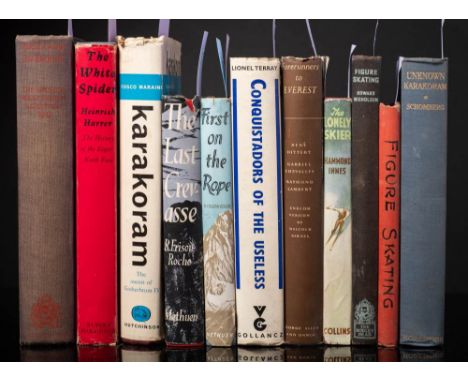
SCHOMBERG, R. C. F - Unknown Karakoram : 23 plates, large folding map in rear pocket, org. cloth, 8vo, Martin Hopkinson, untidy inscription on front paste down, first edit, 1936. With 8 other mountaineering books and 6 Alpine Journals ( two from the 1930s, 4 from the 1950s) with 3 books on skating..(17)
-
109182 item(s)/page