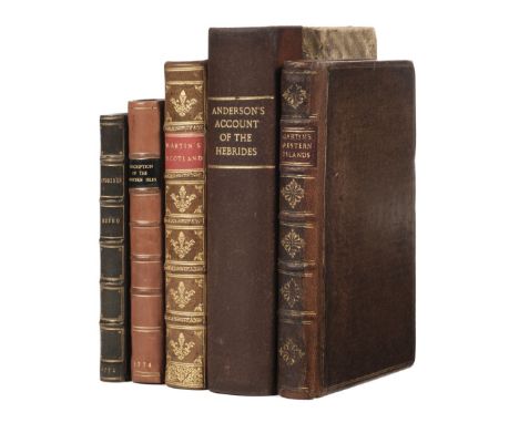

Monro (Donald, & others). Description of the Western Isles of Scotland, called Hybrides; by Mr Donald Monro ... who travelled through most of them in the year 1549 ... Now first published from the Manuscript. To which is added, I. An Account of Hirta and Rona; by the Lord Register Sir George Mckenzie of Tarbat, never before published. II. Description of Saint Kilda, by Mr Alexander Buchan ... III. A Voyage to Saint Kilda in 1697, by M. Martin, 1st edition, Edinburgh: William Auld, 1774, occasional soiling, c.1900 dark green morocco gilt, 8vo (16.2 x 10 cm), together with: Martin (Martin). A Description of the Western Islands of Scotland, 1st edition, London: for Andrew Bell, 1703, engraved folding map (with repaired closed tear), folding plate, text browned, contemporary panelled calf, rebacked, 8vo (19.2 x 11 cm), ibid. A Description of the Western Islands of Scotland, 2nd edition ('very much corrected'), London: for A. Bell [and others], 1716, engraved folding map, folding plate, map and plate each with repaired closed tear, bookplate of Victor Albert George Child Villers, 7th Earl of Jersey (1845-1915), contemporary mottled calf, rebacked retaining most of original spine, 8vo (19.2 x 11.5 cm) Anderson (James). An Account of the Present State of the Hebrides and Western Coasts of Scotland, 1st edition, Edinburgh: for G. Robinson and C. Elliot, 1785, engraved plan, folding table, engraved folding map loose (browned, laid down, with crude tape-repairs and concomitant stains), occasional spotting, 20th-century pigskin backing early marbled boards, 8vo (21.1 x 12.6 cm), and another copy of Monro, Description of the Western Isles, 1774 (title-page damp-stained, some other spotting and soiling, edges untrimmed, 20th-century half calf)Qty: (5)NOTESTHE DAVID WILSON LIBRARY PART III: SCOTLAND, HIGHLANDS & ISLANDS ESTC T90619 (Monro & others), T94240 (Martin, first edition), T31703 (Martin, second edition), T141551 (Anderson); Hanson 263 (Martin).
We found 109182 price guide item(s) matching your search
There are 109182 lots that match your search criteria. Subscribe now to get instant access to the full price guide service.
Click here to subscribe- List
- Grid
-
109182 item(s)/page

Thomson (John, publisher). A Map of the Island of Matrimony, circa 1820, engraved allegorical map with contemporary outline colouring, two repaired closed tears, slight spotting and dust soiling, 170 x 205 mmQty: (1)NOTESA rare allegorical map. The map is divided into regions and areas based upon mythical Greek references, with each region centred on a Greek temple together with an emotional stage or sensibility passed through on the journey to love and matrimony. John Thompson was based in Edinburgh and produced several mainstream cartographic atlases and maps, but this would appear to be a separately published item, possibly created for his own amusement. It's rarity on the market would suggest that it may not have been offered commercially.

Liverpool. Parry (G. H, designed by A. Preston), A Map of Merseyside with Historical & Literary Allusions, Philip Son & Nephew Ltd, circa 1935, colour lithographic decorative pictorial map, old folds, very slight professional strengthening to old folds on verso, 485 x 750 mm, supplied with its contemporary card wrapper, wrappers dust-soiled and a little creasedQty: (1)


Hong Kong. Hong Kong and the New Territories, 3rd edition (with grid correction), War office publication, 1946, Reprinted from HIND 1015, Mar. 1946 Edition, by O.S.1949, colour printed photolithographic map, old folds with two very short closed tears where folds have worn, slight creasing, 680 x 1000 mmQty: (1)NOTESThe map illustrates in great detail, Hong Kong, mainland China and the surrounding islands. A note in the legend at lower right states: 'the area of Chinese territory on this sheet is compiled from material of doubtful value, but is probably a fair general representation of the country.' Although Japan had surrendered in 1945 and the British reclaimed their territory two weeks later, it took until 1949 for the British Government to make a firm decision not to abandon Hong Kong to the Chinese Communists. It had substantially strengthened the garrison to serve as an anti-communist deterrent, but its primary aim was to subdue internal security threats and reassure both the resident British and Hong Kong Chinese residents and bring some much-needed security and stability to the region. Chinese forces had massed on the New Territories border in October of 1949, but there was a degree of posturing and sabre-rattling in this show of strength and they would eventually withdraw.
Reid (John Eaton). History of the County of Bute, and Families connected therewith, 1st edition, Glasgow: Thomas Murray and Son, 1864, 8 albumen print photographs by Thomas Annan each on separate card mount with printed caption, folding lithographic plate, map, occasional light spotting to text, a little mild fading to albumen prints, modern quarter calf, 4to (28.2 x 20.6 cm), together with: Heron (Robert). General View of the Natural Circumstances of those Isles, Adjacent to the North-West Coast of Scotland, which are distinguished by the Common Name of Hebudae or Hebrides, 1st edition, Edinburgh: John Paterson, 1794, half-title discarded, upper fore corner of first 3 leaves consolidated, modern half calf, 4to (27 x 21 cm), [Browne, James]. A Critical Examination of Dr. MacCulloch's Work on the Highlands and Western Isles of Scotland, 1st edition, Edinburgh: Daniel Lizars, 1825, half-title discarded, spotting, edges untrimmed, modern half calf 8vo (20 x 11.5 cm), [Burt, Edward]. Letters from a Gentleman in the North of Scotland to his Friend in London, 2 volumes, 5th edition, London: for Ogle, Duncan, and Co., 1822, engraved frontispieces (offset), no half-titles, edges untrimmed, 20th-century red half calf by Maltby of Oxford, 8vo (22.6 x 13.2 cm), and 3 others, Highlands-related, including MacCulloch, A Description of the Western Islands of Scotland, 1st edition, 1819 (text volumes only; not collated)Qty: (9)NOTESTHE DAVID WILSON LIBRARY PART III: SCOTLAND, HIGHLANDS & ISLANDS ESTC T40705 (Heron); Gernsheim 227 (Reid: erroneously described as containing nine photographs); Kress B2758 (Heron).

Scotland. Blaeu (Johannes & Pont Timothy), Scotiae Provinciae Mediterraneae inter Taum Flumen et Cararis Aestuarium: Sunt autem Braid-Allaban, Atholia, Marria Superior, Badenocha, Strath-Spea, Lochabria..., A description of the Inland Provinces of Scotland lying between Tay River and Murra Forth..., Amsterdam, circa 1645, engraved map with contemporary outline colouring, 420 x 535 mm, Dutch text on versoQty: (1)
Vergilius Maro (Publius). Virgil's Aeneis, translated into Scottish Verse by the Famous Gawin Douglas, Bishop of Dunkeld. A new edition. Wherein the many errors of the former are corrected, and the defects supply'd, from an excellent manuscript. To which is added a large glossary, explaining the difficult words: which may serve for a dictionary to the old Scottish Language, Edingburgh: printed by Andrew Symson and Robert Freebairn, 1710, main text commencing on A2, i.e. p. 3 (as usual), bound without subscribers list, occasional spotting and browning, a few leaves with marginal ink stains, later half calf, spine a little rubbed and faded with small wormtrack, folio, together with [Adams, John]. Index Villaris: or, an Exact Register, Alphabetically Digested, of all the Cities, Market-Towns, Parishes, Villages, the Hundred, Lath, Rape, Ward, Wapentake, or other Division of each County... Hereto is added a perfect catalogue of the nobility of England and Wales, to the present time, May 20. 1690. with their respective seats, and the counties wherein they are scituate, 1st edition, London: printed for T. Sawbridge and M. Gillyflower, 1690, lacking half title and folding map, a little minor soiling and small marginal water stain, contemporary inscription at head of title 'Bought of Wm. Robins, 1690', previous owner signature erased, contemporary panelled calf, modern reback and repairs, folioQty: (2)NOTESESTC T139442 and Wing A481 respectively.

Livonia. Homann (Johannes Baptist), Ducatuum Livoniae et Curlandiae cum vicinis Insulis Nova Exhibitio Geographica, Amsterdam, circa 1720, engraved map with bright contemporary hand colouring, large uncoloured cartouche and mileage scale, trimmed with slight loss to the printed margin in the upper left corner, two small marginal repaired tears, 485 x 580 mm, together with Ortelius (Abraham). Pomeraniae Wandalicae Regionis Typ. [on sheet with] Livoniae Nova descriptio [and] Ducatus Oswieczensis et Zatoriensis Descriptio, [1573], three uncoloured engraved maps on one sheet (as published), faintly red-ruled, slight marginal soiling, overall size 385 x 500 mm, Latin text on versoQty: (2)NOTESThe second map described. Marcel Van den Broecke, Ortelius Atlas Maps, no. 158.

Germany. Braun (Georg & Hogenberg Franz), Calcaria Ducatus Clivensis Multis Dotibus Nobile Opp: circa 1618, coloured engraved plan of Kalkar near Kleve in Northern Westphalia, 330 x 475 mm, German text on verso, together with Ortelius (Gerard). Rhetiae alpestris descriptio in qua hodie Tirolis Comitatus [on sheet with] Goritiae Karstii Chaczeolae Carniolae Histriae et Windorum Marchae Descrip, [1589], two hand-coloured engraved maps on one sheet (as published), the left-hand map covers the Tyrol (northeastern Italy and western Austria) and the right-hand map covers Istria and Slovenia, overall size 345 x 505 mm, German text on versoQty: (2)NOTESThe second item. Marcel van den Broecke, Ortelius Atlas Maps, no. 166.

Jigsaw. Love to her Creator. Jigsaw map of love and emotion, circa 1830, engraved 24 piece heartshaped jigsaw of paper on wood construction, with contemporary hand colouring, four lines of verso above the heart, two 'lugs' missing, 200 x 170 mmQty: (1)NOTESAn unusual 'jigsaw map' concerned with female sentiments and emotions. The overall design is reminiscent of a locket.

London. Geographia Ltd (publisher). The New Pictorial Map of London, circa 1935, folding chromolithographic pictorial and allegorical map of London, laid on contemporary linen, two inset maps showing the location of Theatres and Cinemas in the West End, 480 x 715 mm, bound in the publisher's decorative card boards, (priced 2/- 3d), together with a smaller version, old folds, 365 x 465 mm, bound in publisher's decorative red & white decorative boards, with the maps of the theatres and cinemas printed on the verso of the upper coverQty: (2)
![[Lewis (Samuel). A Topographical Dictionary of England ..., Atlas volume only, London: S.Lewis and Co., 1831], title deficien](https://cdn.globalauctionplatform.com/097ee6b6-2081-432a-b7f6-ac6000a6c3d8/6c321ed9-c7ed-4ad8-a4c0-ac6001173049/468x382.jpg)
[Lewis (Samuel). A Topographical Dictionary of England ..., Atlas volume only, London: S.Lewis and Co., 1831], title deficient, folding engraved map of England and Wales and folding engraved plan of London, both with some light spotting, each with a closed handling tear, the former also with a tear to blank margin, 43 uncoloured engraved maps (including 13 folding), toning and spotting (mostly to margins), 1 with tear to blank margin, Yorkshire with handling tears, contemporary cloth, worn, faded and marked, rear joint cracked, 4toQty: (1)
![Beveridge (Erskine). Wanderings with a Camera 1882-1898, 2 volumes, 1st edition, Edinburgh: privately printed [by] William Br](https://cdn.globalauctionplatform.com/097ee6b6-2081-432a-b7f6-ac6000a6c3d8/4624c35b-3811-4d67-87e0-ac600117352a/468x382.jpg)
Beveridge (Erskine). Wanderings with a Camera 1882-1898, 2 volumes, 1st edition, Edinburgh: privately printed [by] William Brown, 1922, 313 collotype photographic plates, top edges gilt, others untrimmed, large 4to, together with: Shackleton (Ernest H.). The Heart of the Antarctic. Being the Story of the British Antarctic Expedition 1907-1909, 2 volumes, 1st edition, London: William Heinemann, 1909, lacking 4 plates and 3 folding maps, pencilled marginalia ('Margery Fisher's annotated copy': David Wilson's pencilled note to front free endpaper), original pictorial cloth, rebacked, 4to, Trollope (Anthony). How the "Mastiffs" went to Iceland, 1st edition, London: Virtue & Co., Limited, 1878, map, 14 lithographic and 2 mounted collotype plates, inner hinges cracked, original cloth, rubbed, loss to spine-ends, front cover darkened, 4to, and 6 others, travel, including another copy of The Heart of the Antarctic, volume 1 only (original cloth, rear joint split)Qty: (11)NOTESTHE DAVID WILSON LIBRARY PART III: SCOTLAND, HIGHLANDS & ISLANDS Beveridge: number 1 of 50 copies only, the editor's copy, inscribed 'John H. Beveridge' on the limitation leaf, and with his bookplate to volume one; John H. Beveridge was the son of Erskine Beveridge. The photographs mainly depict views in Scotland, but there are also some 40 plates of views in North America including Utah, Idaho, California and British Columbia.
![* Gloucestershire. Saxton (C. & Hole G.), Glocestriae comitatus olim sedes Dobunorum, [1637], hand-coloured engraved map,](https://cdn.globalauctionplatform.com/097ee6b6-2081-432a-b7f6-ac6000a6c3d8/8344df36-9fb2-403b-bb02-ac600117d279/468x382.jpg)
* Gloucestershire. Saxton (C. & Hole G.), Glocestriae comitatus olim sedes Dobunorum, [1637], hand-coloured engraved map, large strapwork cartouche, compass rose and mileage scale, slight overall toning, 285 x 315 mm, mounted, framed and glazed, together with Saxton (C. & Kip W.). Merionith Comitatus olim pars Ordovicum, [1610], hand-coloured engraved map, large strapwork cartouche, 270 x 320 mm, mounted, with Moule (Thomas). Gloucestershire, Kent, Monmouthshire & Cumberland, circa 1848, together four hand-coloured engraved maps, each approximately 260 x 205 mm, mounted, Cumberland framed and glazed, plus Owen (J. & Bowen E.). A Map of Essex [and] A Map of Hampshire [1720 or later], two hand-coloured engraved maps, each 180 x 115 mm, mounted, framed and glazed, with Cary (John). Hampshire, 1787, engraved map with contemporary outline colouring, 275 x 225 mm, mounted and Walpole (George A.). A New Map of Glocestershire drawn from the latest Authorities, circa 1785, hand-coloured engraved map, 220 x 135 mm, mountedQty: (10)

Murray (Sir John, & Laurence Pullar). Bathymetrical Survey of the Scottish Fresh-Water Lochs, 5 volumes, 1st edition, Edinburgh: Challenger Office, 1910, 17 plates and maps in volume 1, volumes 2-6 containing 239 colour lithographic maps (numbered 1-105 and 1-234), all backed on linen, nearly all folding, original half pigskin gilt, 8vo, together with: [Botfield, Beriah]. Journal of a Tour through the Highlands of Scotland during the Summer of MDCCCXXIX, 1st edition, Norton Hall, [Northamptonshire]: [for the author], 1830, engraved frontispiece and additional title-page, 2 apparently autograph clipped signatures of Botfield laid in, gilt edges, near-contemporary green morocco, 12mo (17.2 x 10 cm), Mackay (William). Urquhart and Glenmoriston. Olden Times in a Highland Parish, 1st edition, Inverness: The Northern Counties Newspaper and Printing and Pubilshing Company, Limited, 1893, half-title, 6 plates including frontispiece, colophon leaf, inscribed 'To Donald Mackay, Esq, from the author, 1894' on the initial blank, gilt edges, contemporary calf, 8vo (20.8 x 13.8 cm), [Scotland]. The Gazetteer of Scotland, Dundee: by F. Ray, for W. Chalmers, 1803, engraved folding map hand-coloured in outline, spotting, contemporary red half morocco, 8vo (20.8 x 12.5 cm), and 7 others, Scottish interest, mainly 19th century, all leather-boundQty: (16)NOTESTHE DAVID WILSON LIBRARY PART III: SCOTLAND, HIGHLANDS & ISLANDS The Journal of a Tour through the Highlands of Scotland appears to be the first published work by noted antiquarian and book collector Beriah Botfield (1807-1863).

Fullerton (James Alexander). Views in the Himalaya and Neilgherry Hills, from Drawings taken during the Years 1845-46-47, [London: Dickinson & Co., 1848], [28] pp., 24 tinted lithographic plates, folding lithographic map, toning, short closed tear to lower margin of preface leaf, marginal browning along edges of plates not affecting images, small marginal damp-stain to plate 1, very small chip to foot of description leaf for plate 10, plate 24 and list of subscribers spotted, map with two partial splits to folds and small closed handling tear to inner extremity of central fold, traces of bookplate to front pastedown, original red cloth lettered and decorated in gilt, a little fraying and wear to spine and extremities, covers slightly soiled but gilt bright, oblong 4toQty: (1)NOTESAbbey Travel 499. Rare. Abbey's copy had a printed overslip with the imprint of Dickinson & Co. to the title-page, on which grounds it is speculated that 'Dickinson's originally undertook to produce the book privately for Colonel Fullerton ... and that they then decided to publish it commercially. The presence of the list of subscribers does not necessarily destroy this theory, since Fullerton may have invited subscribers himself. The list contains 106 names'.

Howlett (Bartholomew). A Selection of Views in the County of Lincoln; Comprising the Principal Towns and Churches, the Remains of Castles and Religious Houses, and Seats of the Nobility and Gentry; with Topographical and Historical Accounts of Each View, London: William Miller, 1805, hand-coloured engraved map frontispiece (offsetting to front free blank), engraved dedication, 50 engraved plates, three engraved divisional plates, engraved vignettes to text (one leaf with vignette of Woolsthorpe Manor excised and relaid), tissue guards, list of subscribers present, bookplates of Keld Fenwick of Witham Hall and W. Wells to front endpaper, all edges gilt, contemporary gilt decorated diced calf, neatly rebacked, 4toQty: (1)NOTESUpcott pp. 558-562

Europe. Homann (Johann Baptist heirs of), Europa Secundum Legitimas Projectionis Stereographicae Regulas..., 1743, engraved map with contemporary hand colouring, additional title in French above map, slight dust soiling, 475 x 545 mm, together with De Wit (Frederick). Nova et Accurata Totius Europae Descriptio, Amsterdam, circa 1680, engraved map with contemporary outline colouring, trimmed to neatline, very heavily wormed creased and torn with areas of loss, crudely repaired on verso, 480 x 560 mmQty: (2)

Grose (Francis). The Antiquities of Scotland, 2 volumes, 1st edition, London: S. Hooper, 1789-91, engraved title-page to each volume, folding map hand-coloured in outline, 190 engraved plates, occasional spotting, map offset, ownership inscriptions 'M. F. Fothergill, 1798' to title-pages (including price paid, '£13:13:0', to volume 1) contemporary engraved armorial bookplates of William Graham of Epsom, Surrey, contemporary mottled calf, twin morocco labels, Greek key roll gilt to sides, volume 1 rebacked with original spine laid down, 4to (26.9 x 17.1 cm), together with: Stoddart (John). Remarks on Local Scenery and Manners in Scotland during the Years 1799 and 1800, 2 volumes, 1st edition, London: William Miller, 1801, engraved title-pages, folding map, 32 coloured aquatint plates, offsetting, all edges gilt, contemporary diced russia gilt, joints rubbed, volume 1 front joint cracking, 8vo (23.2 x 15.7 cm), Forsyth (Robert). The Beauties of Scotland: containing a Clear and Full Account of the Agriculture, Commerce, Mines, and Manufactures; of the Population, Cities, Towns, Villages, etc. of each County, 5 volumes, 1st edition, Edinburgh: for Thomson Bonar and John Brown [and others], 1805-8, engraved additional title-page to each volume, folding map (hand-coloured),108 engraved plates (text not collated), spotting and marginal damp-stains to a few plates mainly in volume 4, near-contemporary half calf, 8vo (23.4 x 14.2 cm), Hall (James). Travels in Scotland, by an Unusual Route: with a Trip to the Orkneys and Hebrides, 2 volumes, 1st edition, London: J. Johnson, 1807, engraved folding map, 29 engraved plates including frontispieces, toning, a few spots and marks, contemporary half calf, 8vo (23.2 x 14 cm), and 2 others (not collated): Miscellanea Scotica, 4 volumes, 1st edition, 1818-20 (contemporary calf, rebacked with original spines laid down), and Transactions of the Society of the Antiquaries of Scotland, volume 1, 1792 (plates, deaccession stamps to title-page, contemporary tree calf)Qty: (16)NOTESTHE DAVID WILSON LIBRARY PART III: SCOTLAND, HIGHLANDS & ISLANDS Abbey Scenery 483 (Stoddart); ESTC T141301 (Grose).

Cardiganshire. Speed (John), Cardigan Shyre described with the due forme of the Shire-town as it was surveyed by J. S. Anno 1610, John Sudbury and George Humble, circa 1627, uncoloured engraved map, an inset town plan of Cardigan, large strapwork cartouche and mileage scale, slight water staining, 385 x 515 mm, English text on verso, together with Caernarvon both Shyre and Shire-towne with the ancient Citie Bangor described, Thomas Bassett & Richard Chiswell, circa 1676, uncoloured engraved map, two inset town plans of Caernarvon and Bangor, slight toning to central fold, 390 x 515 mm, English text on verso, with Saxton (Christopher & Kip G.). Anglesey Comitatus olim Mona Insula Druidum sedes Britannice Tir Mon, [1610], engraved map with sparse outline colouring, 260 x 190 mm, plus Blome (Richard). A Mapp of the County of Monmouthshire with Hundreds..., [1673], engraved map with outline colouring, one repaired marginal tear just affecting image, old folds, 315 x 250 mmQty: (4)
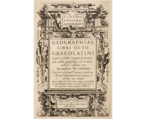
Mercator (Gerard) - Ptolemaeus (Claudius). Geographiae libri octo Graeco-Latini, Amsterdam: Cornelis Nicolai (i.e. Claesz) & Jodocus Hondius, 1605, engraved title, engraved half-page portrait of Gerard Mercator, 28 engraved maps by Mercator, all but one double-page, illustrations, Great Britain map with lower corner torn away, occasional small pale marginal water stain, 18th century calf, spine with raised bands, morocco label and gilt decoration, upper cover detached, small wormtrack, edges a little rubbed, folio, 41.5 x 28 cmQty: (1)NOTESKoeman II Me 3 (variant c). The first edition of Ptolemy's Geographia with parallel Latin and Greek text. 'The Ptolemy edition of 1605 is the first work printed in Greek in Amsterdam and a typographic masterpiece.' (Koeman). Gerard Mercator had first engraved the maps for the 1578 edition, adding the single-page map of the Nile delta. Following his death his stock of maps was acquired by Jodocus Hondius in 1604 and together with Cornelis Claesz produced this atlas in 1605.

* Dorset. Speed (John), Dorsetshyre with the Shyre Towne Dorchester described, as also the Armes of such noble families as have bene honored with the titles thereof since the Normans Conquest to this present, circa 1608, uncoloured engraved map, inset town plan of Dorchester, some spotting and staining, central fold partially split and creased, some marginal creasing, 390 x 515 mm, framed and glazedQty: (1)NOTESA rare early pre-publication state with the date shown as 1608 (as opposed to 1610 on the first edition) and lacking the engravers name and privilege (Jodocus Hondius).
![Ogilby (John). The Road from Bristol com. Gloc. to West Chester [and] The Road from the City of Salisbury com. Wilts to Campd](https://cdn.globalauctionplatform.com/097ee6b6-2081-432a-b7f6-ac6000a6c3d8/b8b1e82f-78b1-4306-839d-ac600117e2a7/468x382.jpg)
Ogilby (John). The Road from Bristol com. Gloc. to West Chester [and] The Road from the City of Salisbury com. Wilts to Campden com Gloc, circa 1676, together two hand-coloured strip road maps, the second map with the right-hand margin trimmed and extended but with no loss to the printed surface, each approximately 340 x 445 mmQty: (2)NOTESSheet numbers 56 & 85. The first map commences at Bristol and passes through Chepstow, Monmouth, Hereford and Leominster and ends at Ludlow. The second map starts at Salisbury and passes through Burbage, Marlborough, Highworth, Lechlade, Burford and Stow-on-the-Wold and ends at Chipping Camden.

Fittler (James, & John Claude Nattes). Scotia Depicta; or the Antiquities, Castles, Public Buildings, Noblemen and Gentlemen's Seats, Cities, Towns, and Picturesque Scenery of Scotland, illustrated in a Series of Finished Etchings by James Fittler, from Accurate Drawings made on the Spot by John Claude Nattes, 1st edition, London: printed by T. Bensley, and published by W. Miller [and others], [1801]-1804, etched additional title-page, letterpress title-page, preface leaf, list of subscribers with contents verso, 48 etched plates each with leaf of descriptive letterpress, etched 'finispiece' including text, all bound in along top edge (the work issued in oblong folio format), light spotting to additional title-page, description leaf for plate 40 browned, contemporary diced russia gilt, rebacked with original spine laid down, folio (40.4 x 27 cm), together with: [Sutherland, Elizabeth Leveson-Gower, Duchess of]. Views in Orkney and on the North-Eastern Coast of Scotland taken in MDCCCV, 1st edition, [London?: privately printed], 1807, 27 pp., half-title, etched title-page, 28 etched plates (a few with multiple images), etched vignettes in text, toning, occasional spotting, without portrait noted in some copies but apparently not called for, top edge gilt, later half morocco, folio (36.6 x 25.2 cm), Drummond (James). Sculptured Monuments in Iona and the West Highlands, 1st edition, Edinburgh: for the Fellows of the Society of Antiquaries of Scotland, 1881, numbered 54 on half-title, 99 tinted lithographic plates, lithographic title-vignette, top edge gilt, contemporary green quarter morocco, vellum tips, joints rubbed, folio (36.4 x 25.2 cm), Gordon (Sir Robert, of Gordonstoun, Bart). A Genealogical History of the Earldom of Sutherland, from its Origin to the Year 1630. With a Continuation to the Year 1651. Published from the Original Manuscript, 1st edition, Edinburgh: for Archibald Constable and Company, 1813, half-title, 3 engraved plates including frontispiece, plates offset, armorial plate damp-stained at foot, bookplate of the Earl of Zetland (earl's coronet with motto 'essayez'), top edge gilt, later 19th-century half morocco gilt, a few holes to front joint, folio (44.2 x 26.2 cm) White (Thomas Pilkington). Archaeological Sketches in Scotland. District of Kintyre, 1st edition, Edinburgh: William Blackwood and Sons, 1873, 53 lithographic plates, map, text-leaves partly unopened, top edge gilt, later maroon quarter morocco, folio (38 x 26.4 cm)Qty: (5)NOTESTHE DAVID WILSON LIBRARY PART III: SCOTLAND, HIGHLANDS & ISLANDS

Bailey (George). Six Etchings of Ye Antient Commandery by George Bailey (of Derby), Worcester, Littlebury & Company, The Worcester Press, At Ye Antient Commandery, circa 1890, 6 etched plates on pale cream wove paper, loose as issued in original wrappers, printed in red and black to upper wrapper, spotted and some wear and minor loss to edges, detached along spine, slim folio, together with a collection of 59 19th century mostly steel engraved and wood-engraved views of Eton College, its buildings, and surrounding countryside, carefully mounted on 22 large card sheets, each with oval ink stamp to lower corner 'Manley Sims Eton Collection', overall sheet size 555 x 410 mm (22 x 16 ins), plus John Bartholomew, The Imperial Map of England & Wales, according to the Ordnance Survey, with the latest additions; shewing clearly every feature of the country, railways and their stations, roads, canals, rivers, gentlemen's seats &c., on the scale of 4-miles to an inch, circa 1860-70, contemporary, half morocco, worn with spine deficient and upper cover detached, atlas folioQty: (24)
![Thomson (John). The Atlas of Scotland, 1st edition, Edinburgh: for John Thomson & Co., 1832, pp. [4] viii 18, engraved 'I](https://cdn.globalauctionplatform.com/097ee6b6-2081-432a-b7f6-ac6000a6c3d8/f8a274f1-8647-41f5-bad4-ac6001175347/468x382.jpg)
Thomson (John). The Atlas of Scotland, 1st edition, Edinburgh: for John Thomson & Co., 1832, pp. [4] viii 18, engraved 'Index Map' hand-coloured in outline, 2 engraved plates ('A Comparative View of the Heights of the Principal Mountains of Scotland' and 'A Comparative View of the Lengths of the Principal Rivers of Scotland') both hand-coloured, folding and mounted on stubs, 29 engraved maps, all folding, mounted on stubs and hand-coloured in outline, a few with inset town plans, many on multiple sheets, printed caption slips to versos, title-page and dedication/contents leaf damp-stained and repaired with loss of imprint, toning, variable offsetting and dust-soiling, marginal nick to foot of Index map, repairs to sheets 3-4 of Edinburghshire, top margins of both sheets of Kirkcudbrightshire and to Ayshire map sheet 3 extending into image, marginal tear to Kincardineshire, light damp-staining to a few maps towards rear, final 2 text-leaves (part of index) with tissue-repairs with loss of text in the latter, a few other marks, modern red crushed half morocco, atlas folio (55 x 40 cm), together with: Bartholomew (J. G.). The Royal Scottish Geographical Society's Atlas of Scotland, 1st edition, Edinburgh: Edinburgh Geographical Institute, 1895, 62 folding colour lithographic maps, all edges gilt, original blue half morocco, folio (44.5 x 30 cm)Qty: (2)NOTESTHE DAVID WILSON LIBRARY PART III: SCOTLAND, HIGHLANDS & ISLANDS Chubb Scotland XXXII (Thomson: 'a splendid atlas').
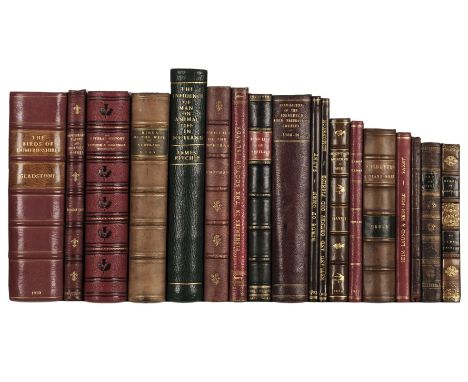
Gladstone (Hugh S.). The Birds of Dumfriesshire, 1st edition, London: Witherby & Co., 1910, half-title, 24 halftone plates, folding map, top edge gilt, modern red half morocco, 8vo (21.2 x 14 cm), number 1 of 350 copies only, together with: Gray (Robert). [Sammelband of 20 ornithological papers and obituaries], c.1880, mainly offprints, possibly compiled by the author, and including The Great Auk (Alca Impennis), Edinburgh: printed by Neill & Co., 1880 (17 pp., 2 photolithographic plates), The Birds of Arran: Glasgow: Bell and Bain, 1872 (27 pp.), manuscript title-page (dated 1883) and contents leaf, top edge gilt, contemporary red half morocco, 8vo (21.6 x 13.5 cm), ibid. The Birds of the West of Scotland including the Outer Hebrides, 1st edition, Glasgow: Thomas Murray & Son, 1871, half-title, 15 tinted lithographic plates including frontispiece, Bodleian Library stamp (cancelled) to title-page and p. 7, contemporary half calf, 8vo (21.4 x 13.2 cm) Macgillivray (William). The Natural History of Dee Side and Braemar. Edited by Edwin Lankester, 1st edition, London: printed for private circulation, 1855, wood-engraved frontispiece and 5 plate, 2 folding maps, without dedication leaf, all edges gilt, contemporary red full morocco, 8vo (21.4 x 12.8 cm), Edmonston (Arthur). Observations on the Nature and Extent of the Cod Fishery, carried on off the Coasts of the Zetland and Orkney Islands, 1st edition, Edinburgh: for William Laing, 1820, pp. 38 [2], title-page browned, modern quarter leather, 8vo (21 x 21.5 cm) and 13 others, Scottish natural history, 19th and early-20th century, leather-bound, 8voQty: (18)NOTESTHE DAVID WILSON LIBRARY PART III: SCOTLAND, HIGHLANDS & ISLANDS Mullens & Swann pp. 233 (Gladstone), 251 (Gray, Birds of the West of Scotland), 371-2 (MacGillivray); Wood pp. 360 (Gladstone), 368 (Gray, Birds of the West of Scotland), 446 (MacGillivray). MacGillivray's work was completed shortly before his death, after which the manuscript was purchased by Queen Victoria and 'printed at her command' (Wood).
![[Shetland; Fisheries]. A True Description of the Island of Shetland, containing an Account of its Situation, Trade, Produce,](https://cdn.globalauctionplatform.com/097ee6b6-2081-432a-b7f6-ac6000a6c3d8/143e4bd6-94fb-44c5-92b3-ac6001174e4f/468x382.jpg)
[Shetland; Fisheries]. A True Description of the Island of Shetland, containing an Account of its Situation, Trade, Produce, and Inhabitants. Together with an Account of the Great White Herring Fishery of that Place, 2nd edition, London: T. James [and others], 1753, toning, some spotting, title-page nicked and marked, top edge gilt, 19th-century half calf, 8vo (18.9 x 12 cm), together with: Hibbert (Samuel). A Description of the Shetland Islands, comprising an Account of their Geology, Scenery, Antiquities, and Supersitions, 1st edition, Edinburgh: Archibald Constable and Co., 1822, 6 engraved plates including frontispiece (2 folding), additional vignette section-title, folding map, engraved vignettes throughout the text (including a 'Plate 2' apparently counted in pagination and register), occasional light browning, plates and map spotted and offset, bookplate (George Seton Veitch), contemporary tan calf, rebacked, craquelure, discolouration and marks to sides, 4to (26.8 x 21.2 cm), ibid. A Description of the Shetland Islands, 2nd edition, Lerwick: T. & J. Manson, 1892, half-title, frontispiece, gilt edges, contemporary half calf, rebacked, 4to (24.6 x 17.5 cm), Edmonston (Arthur). A View of the Ancient and Present State of the Zetland Islands, 2 volumes, 1st edition, Edinburgh: for Longman, Hurst, Rees, and Orme, 1809, half-titles, folding map (browned and offset), 20th-century green quarter morocco, 8vo (21.1 x 13 cm), Manson (Thomas, editor). Shetland's Roll of Honour and Roll of Service, 1st edition, Lerwick: T. & J. Manson, 1920, half-title, 70 plates (paginated 1-140) containing 560 halftone portrait photographs, contemporary half calf, 4to (27.9 x 21 cm), Grant (Francis J.). The County Families of the Zetland Islands, 1st edition, Lerwick: T. & J. Manson, 1893, half-title, frontispiece, fore and bottom edges untrimmed, contemporary quarter calf, 4to (25.1 x 18.5 cm), and 11 others (not collated), all Shetland-related, 19th and early-20th century, including Catton, History and Description of the Shetland Islands, 1st edition, 1838, Saxby, The Birds of Shetland, 1st edition, 1874, and Holbourn, The Isle of Foula, 1st edition, Lerwick, 1938, 3 other copies of Hibbert (2 copies of the 1st edition, 1822, and a 2nd edition, 1892), and another copy of Edmonston, 1st edition, leather bindings, various formatsQty: (19)NOTESTHE DAVID WILSON LIBRARY PART III: SCOTLAND, HIGHLANDS & ISLANDS ESTC T94721 (A True Description: six copies in UK libraries); Ward & Carozzi 1062 (Hibbert, first edition).

Northamptonshire. Faden (Robert), The County of Northampton as Surveyed and Planned by the late Mr Thomas Eyre of Kettering, Revised by the late Mr Thomas Jefferys geographer to the King and engraved by Willam Faden..., 1st edition, 2nd August 1780, large scale engraved map on four sheets with contemporary outline colouring, engraved views of Geddington Cross and Queens Cross, old folds strengthened on verso where folds cross, some spotting and browning, each sheet approximately 625 x 680 mmQty: (1)
![* Poland. Ortelius (Abraham), Poloniae Finitimarumque Locorum Descriptio Auctore Wenceslao Godreccio Polono, [1581], engraved](https://cdn.globalauctionplatform.com/097ee6b6-2081-432a-b7f6-ac6000a6c3d8/e571172c-060e-444c-a036-ac600117e809/468x382.jpg)
* Poland. Ortelius (Abraham), Poloniae Finitimarumque Locorum Descriptio Auctore Wenceslao Godreccio Polono, [1581], engraved map with contemporary hand colouring, 375 x 500 mm, mounted with another similar example, double aperture mount, framed and glazedQty: (1)NOTESMarcel Van Den Broecke. Ortelius Atlas Maps, 154.
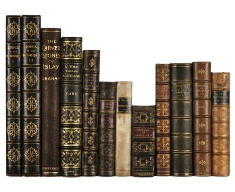
Carr (Sir John). Caledonian Sketches, or a Tour through Scotland in 1807, 1st edition, London: for Mathews and Leigh, 1809, 12 aquatint plates including folding frontispiece, all with later hand-colouring, blind stamp of Maidstone Museum and Public Libraries to title-page, spotting and offsetting to text-leaves adjacent to plates, final page (p. 542, with advertisement) overlaid with translucent paper, contemporary green morocco gilt, rebacked to style, 4to (26.4 x 19.5 cm), together with: Reid (John T.). Art Rambles in the Highlands and Islands of Scotland, 1st edition, London: George Routledge and Sons, 1878, 40 wood-engraved plates and numerous vignettes by Dalziel Brothers, inscribed 'Mrs Dodd, with kind regards from Dalziel Brothers, Christmas 1877' on initial blank, bookplate of Charles Robert Bignold (1892-1970), gilt edges, near-contemporary dark green crushed morocco gilt by Ramage, 4to (24.2 x 17.2 cm), Graham (Robert C.). The Carved Stones of Islay, 1st edition, Glasgow: James Maclehose and Sons, 1895, half-title, etched additional title, map, 32 plates with captioned tissue-guards (nearly all photogravures), top edges gilt, others untrimmed, original quarter cloth, a little pale mottling to sides, 4to, [Mudie, Robert]. A Historical Account of His Majesty's Visit to Scotland, 4th edition, Edinburgh: Oliver & Boyd, 1822, 4 engraved folding plates backed on linen, one other folding plate, plates variably toned and spotted, first plate unevenly folded, gilt gauffered edges, contemporary maroon morocco gilt, arms of the city of Edinburgh to sides, 8vo (21.4 x 12.5 cm), and 7 similar, Scottish history and related, 19th and early-20th century, all finely bound, including Marjory Kennedy-Fraser and Kenneth Cloud, Songs of the Hebrides, volumes 1-2, 1909-17 (half-title, 3 halftone plates, collation unknown, contemporary dark blue morocco gilt for Maclehose, 4to)Qty: (12)NOTESTHE DAVID WILSON LIBRARY PART III: SCOTLAND, HIGHLANDS & ISLANDS Abbey Scenery 488 (Carr).
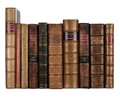
Sinclair (Sir John). General View of the Agriculture of the Northern Counties and Islands of Scotland; Including the Counties of Cromarty, Ross, Sutherland, and Caithness, and the Islands of Orkney and Shetland. With Observations on the means of their Improvement, London: Colin Macrae, 1795, half-title lined to verso, small repair to lower outer blank corner of title, folding hand-coloured engraved map, some dust-soiling mostly to first & last few leaves, modern half calf, maroon morocco title label to spine, 4to, together with: Naismith (John), General View of the Agriculture of the County of Clydesdale..., Glasgow: Mundell & Son, 1798, folding engraved map frontispiece, light offsetting to title, modern half calf, spine faded, 8vo, Smith (John), General View of the Agriculture of the County of Argyll..., Edinburgh: Printed by Mundell & Son, 1798, one folding table, contemporary half calf, rebacked, 8vo, Thomson (John), General View of the Agriculture of the County of Fife..., Edinburgh: Printed by J. Moir, 1800, folding engraved map frontispiece (closed tear to blank margin at gutter), 3 engraved plates, endpapers renewed, contemporary marbled boards with recent calf spine and contrasting morocco labels, board edges worn, 8vo, Leslie (William), General View of the Agriculture in the Counties of Nairn and Moray ... Drawn up for the Board of Agriculture and Internal Improvement , London: Richard Phillips, 1811, folding hand-coloured engraved map frontispiece, signature at head of title, light scattered spotting, armorial bookplate of James Brodie of Brodie to upper pastedown, contemporary half calf, gilt crest to upper panel of spine, some light rubbing to spine, 8vo, Aiton (William). General View of the Agriculture of the County of Ayr; with Observations on the means of its Improvement, Drawn up for the Consideration of the Board of Agriculture..., Glasgow: Sir Richard Phillips, 1811, half-title, folding engraved plan frontispiece, 7 engraved plates, plans & maps (6 folding), contemporary half calf, joints cracked, 8vo, Keith (George Skene), A General View of the Agriculture of Aberdeenshire..., Aberdeen: Printed by D. Chalmers & Co., for A. Brown, A. Constable, et al., 1811, folding hand-coloured engraved map frontispiece, 4 engreved plates & plans (2 folding), some offsetting, toning and spotting, edges untrimmed, modern half calf, 8vo, and 3 others similar, including General View of the Agriculture of Renfrewshire, by John Wilson, Paisley, 1812; General View of the Agriculture of the County of Berwick, by Robert Kerr, London, 1813; and General View of the Agriculture, State of Property, and Improvements, in the County of Dumfries, by Dr [William] Singer, Edinburgh, 1812Qty: (10)NOTESTHE DAVID WILSON LIBRARY PART III: SCOTLAND, HIGHLANDS & ISLANDS Kress B3034 (Sinclair), B4299 (Thomson), B5853 (Leslie), B5847 (Keith).


Scotland. Blaeu (Johannes & Pont Timothy), Lidalia vel Lidisdalia Regio, Lidisdall, Amsterdam, circa 1654, engraved map with contemporary outline colouring, large decorative cartouche and mileage scale, slight creasing, small blind stamp to lower right corner, 415 x 530 mm, Latin text on verso, mounted, together with Praefectura Kircubriensis quae Gallovidiae Maxime Orientalis pars est. The Steuartrie of Kircubright, The most Easterlie part of Galloway, Amsterdam, [1654 - 62], engraved map with contemporary hand colouring, large decorative cartouche, 425 x 545 mm, no text on verso, mounted, with Fife pars Occidentalis, The West part of Fife, Amsterdam, circa 1654, engraved map with contemporary outline colouring, two repaired marginal closed tears, just affecting printed image, 420 x 540 mm, Dutch text on verso, plus Mercia vulgo vice comitatus Bervicensis, The Merce or Shirrefdome of Berwick, Amsterdam, Circa 1654, engraved map with contemporary hand colouring, one very small hole repaired on verso, 385 x 505 mm, Latin text on versoQty: (4)

Loch (James). An Account of the Improvements on the Estates of the Marquess of Stafford in the Counties of Stafford and Salop, and on the Estate of Sutherland, 1st edition, London: Longman, Hurst, Rees, Orme, and Brown, 1820, pp. xx;236;118;4, half-title, engraved folding map as frontispiece, 39 numbered engraved plans (some hand-coloured and/or folding), folding table, plate 4 torn and stained, a few other faint damp-stains, edges untrimmed, 20th-century marbled half calf to style by Bayntun, gilt spine, 8vo (22.2 x 13.7 cm), together with: MacCulloch (John). The Highlands and Western Isles of Scotland ... founded on a Series of Annual Journeys between the Years 1811 and 1821, and forming an Universal Guide to that Country, in Letters to Sir Walter Scott, Bart., 4 volumes, 1st edition, London: Longman, Hurst, Rees, Orme, Brown, and Green, 1824, contemporary tan calf gilt, 8vo (21.5 x 12.7 cm), Walker (John). An Economical History of the Hebrides and Highlands of Scotland, 2 volumes, 2nd edition, London: Longman, Hurst, Rees, and Orme, 1812, ownership inscriptions dated 1831 to title-pages, contemporary half calf, green morocco labels, 8vo (21.5 x 12.7 cm), and 5 others (not collated), including: Maxwell, Highlands and Islands, 2 volumes, 1st edition, 1852 (lacking half-titles); [Browne], A Critical Examination of Dr. MacCulloch's Work, 2 copies, 1st and 2nd editions, 1825 and 1826; Smith, Excursions through the Highlands and Isles of Scotland in 1836 and 1836, 1st edition, 1837; and another copy of MacCulloch, The Highlands and Western Isles, 1824; all in leather bindings, 8voQty: (16)NOTESTHE DAVID WILSON LIBRARY PART III: SCOTLAND, HIGHLANDS & ISLANDS Kress C571 (Loch), B6076 (Walker). A few library records cite 42 plates for Loch's work, but the folding map and 39 numbered plans are the maximum complement which appears in commercial records.
Morton (John). The Natural History of Northampton-shire; with some Account of the Antiquities. To which is annex'd a Transcript of Doomsday-Book so far as it relates to that County, 1st edition, London: R. Knaplock and R. Wilkin, 1712, engraved folding map by John Harris (detached and browned), 14 engraved plates, verso of title and A2 with early ownership signature (consequent show-through to recto of title), occasional early marginalia throughout volume, some light toning mostly to margins, ownership inscription to front endpaper (free endpapers detached), contemporary panelled calf, gilt decorated spine with calf title label, covers rubbed and worn, boards detached, folio (Upcott pp.1003-1005), together with: Markham (Christopher A. & Cox, J. Charles), The Records of the Borough of Northampton, 2 volumes, published by Order of the Corporation o the County Borough of Northampton, London: Elliot Stock; Northampton: Birdsall & Son, 1898, titles in red & black, few photogravure & monochrome plates, folding lithograph plan in rear pocket of volume 2, top edge gilt, remainder untrimmed, contemporary half vellum gilt by Birdsall of Northampton, large 8vo (limited edition 4/600, this being one of 100 printed on large paper), Bonney (Henry Kaye), Historic Notices in Reference to Fotheringhay, Oudle: T. Bell, 1821, engraved frontispiece and eight plates, scattered spotting and some offsetting, top edge gilt, remainder untrimmed, front hinge crudely repaired, later 19th century black half calf by Birdsall & Son of Northampton, upper board detached (adhesive residue to joint edge), lower joint split, 8voQty: (4)

Europe. Mansfeld (J. E.), Post Charte der Kaiserl. Konigl. Erblanden..., George Metzburg, Vienna, 1782, a large engraved map with contemporary outline colouring, sectionalised and laid on linen, large uncoloured cartouche, and mileage scale, 1010 x 1515 mm, printed card chemise, contained in a contemporary calf slipcase with red morocco label to upper cover, worn and rubbedQty: (1)NOTESA scarce postal route map for the Austrian Empire. The map has Vienna at its centre but extends to Berlin, Bucharest, Rome and Paris.

Smith (Charles). Smith's New English Atlas being a complete set fo County maps, Divided into Hundreds..., 1804, 2nd edition corrected to 1808, calligraphic title, index, a general map of England & Wales, 45 (complete as list) double-page engraved maps with contemporary hand colouring, the map of England & Wales with some toning and browning, title page and index spotted and waterstained, index and list of subscribers bound at rear, endpapers and end leaves creased, hinges crudely repaired with tape, near-contemporary half calf, re-backed but retaining original spine, the boards and spine heavily varnished, rubbed and worn at extremities, folioQty: (1)NOTESChubb. CCCXII
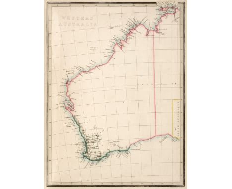
Wyld (James). An Atlas of the World, comprehending Separate Maps of its Various Countries, constructed and drawn from the latest Astronomical and Geographical Observations, London: James Wyld, 1853, engraved title-page, letterpress contents leaf, 4 engraved tables numbered 1-5 (one double-page), 46 hand-coloured engraved maps numbered 6-54 (maps 19-22, 'The Confederated States of Germany' etc. on one enlarged folding sheet; with short split to one fold), South Africa map closely trimmed as usual, pencilled ownership inscription to head of title-page, 20th-century book-label to front free endpaper, original red half morocco, 4to (33.1 x 25 cm)Qty: (1)NOTESProvenance: David R. Wilson (1926-2020), bookseller and secretary of the British Trust for Ornithology. Contains four maps of Australia ('Gold Regions of Australia', 'Western Australia', 'Map of the Settlements of New South Wales' and 'Van Diemen's Land'), a general map of North America, 'Map of the British Possessions in North America' (i.e. Canada), and 'Map of the United States of North America', the latter showing the comparatively new state of Texas and with the land west of the Missouri River labelled 'Missouri Territory'.
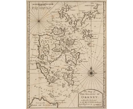
Wallace (James). An Account of the Islands of Orkney. To which is added, an Essay concerning the Thule of the Ancients, 2nd edition, London: for Jacob Tonson, 1700, engraved folding map and plate, light uniform browning, contemporary panelled calf, rebacked, 8vo (19.1 x 11.5 cm), together with: [Groat, Alexander G.]. Thoughts on Orkney and Zetland, their Antiquities and Capabilities of Improvement ... Not printed for sale, 1st edition, Edinburgh: Neill & Co., 1831, half-title (marked), title-page with contemporary ownership inscription (Sir Howard Elphinstone, Bart) and shallow marginal chip, later cloth, 8vo (21.2 x 13.4 cm), Neill (Patrick). A Tour through some of the Islands of Orkney and Shetland, 1st edition, Edinburgh: for A. Constable and Company, 1806, half-title and advertisements discarded, deleted ownership inscription on title-page, near-contemporary half morocco, 8vo (21.5 x 12.8 cm), Peterkin (Alexander). Notes on Orkney and Zetland: illustrative of the History, Antiquities, Scenery, and Customs of those Islands. Vol. I [all published], 1st edition, Edinburgh: by John Moir, for Macredie, Skelly, and Company, 1822, 2 engraved plates, half-title discarded, plates browned and damp-stained, repaired closed tear in title-page, spotting, edges untrimmed, modern half calf, 8vo (22 x 13.5 cm), and 5 others, including 2 other copies of Wallace, An Account of the Islands of Orkney, 1st edition, 1700 (one in contemporary sheep, with map and plate both closely trimmed cropping part of image in plate, map with closed tear repaired verso; the other in contemporary panelled sheep, with map and plate in facsimile, and 16 pp. advertisements not mentioned in ESTC), Peterkin, Rentals of the Ancient Earldom and Bishopric of Orkney, 1st edition, 1820, a sammelband of 19th-century guides to the Orkneys and Shetland with maps, and Odal Rights and Feudal Wrongs: A Memorial for Orkney, Edinburgh, 1860, these last 3 not collatedQty: (9)NOTESTHE DAVID WILSON LIBRARY PART III: SCOTLAND, HIGHLANDS & ISLANDS ESTC R34706 (Wallace); Mullens & Swann pp. 609 (Wallace), 431 (Neill); Wing W491 (Wallace). Wallace's work was first printed in Edinburgh in 1693.
Macdonald (James). General View of the Agriculture of the Hebrides, or Western Isles of Scotland, 1st edition, Edinburgh: Sir Richard Phillips, 1811, engraved plate and 5 folding maps, browning and some spotting, edges untrimmed, modern half calf, morocco title label, 8vo, together with: Robertson (James), General View of the Agriculture in the County of Perth: with Observations on the Means of its Improvement, 2nd edition, Perth: Printed by R. Morison, under the Patronage of the Board of Agriculture, 1813, folding engraved hand-coloured map frontispiece, 5 engraved plates, 2 folding tables, some spotting and toning, contemporary quarter calf, rebacked, vellum tips, 8vo, Shirreff (John), General View of the Agriculture of the Orkney Islands, 1st edition, Edinburgh: Printed by Stevenson & Company, for Archibald Constable & Co., 1814, small ink stain to title, numerous folding tables, some spotting and light toning, modern half calf, 8vo, Robertson (George), General View of Agriculture of Kincardineshire, or the Mearns, 1st edition, London: Sherwood, Neely, & Jones, 1813, folding hand-coloured engraved map, engraved plate, folding plan and tables, light toning, contemporary calf with Limerick Institution embossed emblem to boards, contrasting skiver labels, boards rubbed, 8vo, Henderson (John), General View of the Agriculture of the County of Caithness, 1st edition, London: Printed by B. McMillan, 1812, 12 folding engraved plates and plans, without folding map frontispiece, light skinning to title, some spotting, later half calf, 8vo, and one other relatedQty: (6)NOTESTHE DAVID WILSON LIBRARY PART III: SCOTLAND, HIGHLANDS & ISLANDS Kress B.5867, B.2821 (for the first edition of 1794), N/A, B.6215, B.5996.
Low (George). A Tour through the Islands of Orkney and Shetland. Containing Hints relative to their Ancient, Modern and Natural History collected in 1774, 1st edition, Kirkwall: William Peace & Son, 1879, half-title, 2 plates including frontispiece, folding map (with closed tear at intersection of folds), contemporary purple half calf gilt, 8vo (21.7 x 13.6 cm), together with: Dennison (Walter Traill). The Orcadian Sketch-Book, being Traits of Old Orkney Life written partly in the Orkney Dialect, 1st edition, Kirkwall: William Peace & Son, 1880, gilt edges, contemporary blue morocco gilt, 8vo (18.4 x 11.9 cm), Malcolm (John). Poems, Tales and Sketches, 1st edition, Kirkwall: William Peace & Son, [1878?], half-title, top edge gilt, contemporary half calf gilt, 8vo (18.2 x 11.8 cm), Webster (David). The History of the Kirkwall United Presbyterian Congregation, 1st edition, Kirkwall: William Peace & Son, 1910, half-title, 21 halftone plates, browning to text-leaves adjacent to plates, contemporary green half calf, uneven fading to covers, 8vo (21.6 x 13.3 cm), Vedder (David). Orcadian Sketches; Legendary and Lyrical Pieces, 1st edition, Edinburgh: William Tait, 1832, half-title (with ink-stamp), untrimmed, original cloth, rebacked and relined, 8vo (18.5 x 11 cm), and 3 others, including James Athearn Jones, Conirdan: or, the St. Kildians. A Moral Tale, 1st edition, 1817 (half-title discarded, spotting and soiling, I6-7 torn with loss), a sammelband of papers and extracts on Orkney and Shetland (bookplate of W. Balfour Stewart, manuscript index, 20th-century half morocco gilt, spine-title 'Orkney and Shetland Antiquities', 4to), and Walter Scott, The Pirate, 3 volumes, 1822 (lacking at least volume 1 title-page)Qty: (10)NOTESTHE DAVID WILSON LIBRARY PART III: SCOTLAND, HIGHLANDS & ISLANDS Freeman 2324 (Low); Mullens & Swann p. 362 (Low).

Scotland. Blaeu (Johannes & Pont Timothy), Moravia Scotiae Provincia..., Amsterdam, circa 1654, engraved map with contemporary outline colouring, 425 x 560 mm, Dutch text on verso, mounted, together with Coila Provincia. The Province of Kyle, Amsterdam, circa 1654, engraved map with contemporary outline colouring, 450 x 570 mm, Dutch text on verso, mounted, with Gallovidiae pars Occidentalior in qua Vicecomitatus Victoniensis cum Regalitate Glenlucensi, Amsterdam, circa 1654, engraved map with contemporary hand colouring, slight spotting and mount staining, slight text show through, 425 x 535 mm, French text on verso, mounted, plus Gallovidiae pars Media quae Deam et Cream fluvious interjacet. The Middle part of Galloway whiche lyeth betweene the rivers Dee and Cree, Amsterdam [1654 - 62], engraved map with contemporary outline colouring, 425 x 550 mm, no text on verso, mountedQty: (4)
Dunn (Robert). The Ornithologist's Guide to the Islands of Orkney and Shetland, 1st edition, London: published by the author, 1837, half-title, lithographic frontispiece, 2 folding maps, spotting to frontispiece, title-page and maps, one map with repaired closed tear, inscribed 'R. C. H. Wallendahl, Esqr, Bergen, Norway, Presented by the author' on half-title, pencilled monogram to front pastedown (ascribed in a pencilled note by David Wilson to F. C. R. Jourdain, ornithologist), original cloth, marked, large 12mo, together with: Catton (James). The History and Description of the Shetland Islands, 1st edition, Wainfleet: P. I. Tuxford, 1838, edges untrimmed, original cloth-backed boards, 8vo, Edmonston (Thomas). A Flora of Shetland, 1st edition, Aberdeen: Geo. Clark and Son, 1845, errata slip, annotations throughout, original cloth, small 8vo, Cowie (Robert). Shetland: Descriptive and Historical; being a Graduation Thesis on the Inhabitants of the Shetland Islands, 1st edition, Aberdeen: Lewis Smith, 1871, folding map, 5 wood-engraved and 1 tinted lithographic plate, ownership inscription of Archibald Greig Cowie (brother of the author) to front free endpaper, original cloth gilt, small 8vo, Saxby (Henry L.). The Birds of Shetland, 1st edition, Edinburgh: Maclachlan and Stewart, 1874, 8 tinted lithographic plates including frontispiece, newspaper cuttings mounted to rear free endpaper, original cloth, recased, 8vo, Spence (John). Shetland Folk-Lore, 1st edition, Lerwick: Johnson & Greig, 1899, frontispiece, original cloth, 8vo, and 25 others, all Shetland-related including Lerwick imprints and novels by Jessie M. Saxby, 19th and early-20th century, nearly all in original cloth, 8voQty: (31)NOTESTHE DAVID WILSON LIBRARY PART III: SCOTLAND, HIGHLANDS & ISLANDS Mullens & Swann pp. 186 (Dunn), 510-11 (Saxby).

Sussex. van Keulen (Gerard), A new gradually encreasing Compass- Map of part of the Sea Coasts of England in which is contined the Coasts of Sussex, extending from Eastwards of Hastings to Arundel Haven, with their shallownesses and Depths, Amsterdam, circa 1724, uncoloured engraved sea chart which includes Brighton, Beachy Head and Hastings, title repeated in Dutch, compass rose and numerous rhumb lines, 520 x 600 mmQty: (1)NOTESOrigianlly published in 'De Nieuwe Groote Ligtende Zee-Fakkel'.

* Lithuania. Jansson (Jan), Magni Ducatus Lithuaniae Caeterarump Regionum illi Adjacentium exacta descrip..., circa 1680, hand-coloured engraved map based on an earlier map by Radziwill, inset map of the lower course of the River Dnieper, three different states displayed in a multi-aperture mount, each map 435 x 540 mm, framed and glazedQty: (1)NOTESThe map extends from Cracow to the Baltic in the west and Kiev and Smolenzio in the east. Jansson's original plate was passed to his heirs - Johannes Waesberghe - who together with Moses Pitt and Stephen Swartr re-published the map in Oxford with the added reticulation.
![[Great Reform Act; Scotland]. Reports upon the Boundaries of the several Cities, Burghs, and Towns in Scotland, in Respect to](https://cdn.globalauctionplatform.com/097ee6b6-2081-432a-b7f6-ac6000a6c3d8/95ba3198-94ff-4557-8192-ac6001173e67/468x382.jpg)
[Great Reform Act; Scotland]. Reports upon the Boundaries of the several Cities, Burghs, and Towns in Scotland, in Respect to the Election of Members fo Serve in Parliament, [London]: ordered to be printed, 18 April 1832, 153 pp., 69 engraved maps (of 71?), nearly all folding, all hand-coloured in outline, offsetting, Aberdeen map with recoverable paper-disruption to central intersection of folds, contemporary marbled boards, rebacked, corners worn, folio (33.8 x 20.2 cm), together with: [Caledonian Canal]. Report of the Commissioners for proceeding in the Execution of an Inland Navigation from the Eastern to the Western Sea, by Inverness and Fort William [ ... Third ... Fourth ... Fifth ... Sixth ... Seventh ... Eighth ... Ninth ... Tenth ... Twelfth ... Thirteenth ... Fourteenth ... Fifteenth ... Seventeenth ... Eighteenth ... Twentieth Report], 16 works in 1 volume, [London]: ordered to be printed 10th April 1804 [-1823], 8 hand-coloured engraved folding maps after A. Arrowsmith (collation for each report unknown but lacking map in first report), map in third report repaired and with marginal tears, map in eighteenth report with marginal tears, all edges untrimmed, modern half calf, folio (34.5 x 20 cm), Royal Commission (Highlands and Islands, 1892). Minutes of Evidence taken before the Royal Commission, Vol. I [bound with:] Report on the Royal Commission (Highlands and Islands, 1892), with Appendices, 2 works in 1 volume, Edinburgh: for Her Majesty's Stationery Office, 1895, original wrappers bound in, modern half calf, folio (33.4 x 20.5 cm), 68 (of at least 70) folding lithographic maps bound in a separate volume, without title-page but evidently related, the maps all headed 'Royal Commission (Highlands and Islands, 1892)', frequent repairs, contemporary cloth, folio (33.8 x 20.8 cm), [Salmon fisheries]. Report of the Special Commissioners appointed to enquire into the Effect of Recent Legislation on the Salmon Fisheries in Scotland. By Frank Buckland and Archibald Young, Edinburgh: for Her Majesty's Stationery Office, 1871, 4 lithographic maps (3 folding), plate, original wrappers bound in, modern quarter calf, folio (33 x 20.2 cm), and 3 others similarQty: (9)NOTESTHE DAVID WILSON LIBRARY PART III: SCOTLAND, HIGHLANDS & ISLANDS Sold as seen, not subject to return.
![[Glencoe massacre]. An Impartial Account of some of the Transactions in Scotland, concerning the Earl of Broadalban, Viscount](https://cdn.globalauctionplatform.com/097ee6b6-2081-432a-b7f6-ac6000a6c3d8/1e029494-27c4-4fa5-9ffa-ac6001173dc4/468x382.jpg)
[Glencoe massacre]. An Impartial Account of some of the Transactions in Scotland, concerning the Earl of Broadalban, Viscount and Master of Stair, Glenco-Men, Bishop of Galloway, and Mr. Duncan Robertson. In a Letter from a Friend, 1st edition, London: printed, and sold by the booksellers of London and Westminster, 1695, [2] 30 pp., errata slip pasted to title-page verso, browning and damp-staining, modern bookplate (David Murray), untrimmed, 19th-century red half morocco, title ('Massacre of Glencoe Etc. - 1695') gilt to spine, 4to (21 x 16.5 cm), together with: [Jacobite rebellion]. A Compleat History of the Rebellion, from its first Rise in 1745, to its total Suppression at the Glorious Battle of Culloden, in April 1746. By Mr. James Ray, of Whitehaven, Volunteer under his Royal Highness the Duke of Cumberland, 1st edition, Mancester: for the author by R. Whitworth, [1747?], pp. 408, a few light damp-stains, stab-holes visible in gutter, contemporary ownership inscriptions (Richard Widdowson of Thrumpton), contemporary panelled calf, rebacked, 12mo (16 x 9.5 cm), ibid. A Journey through Part of England and Scotland along with the Army under the Command of His Royal Highness the Duke of Cumberland ... By a Volunteer, 2nd edition, London: T. Osborne, 1747, worming, contemporary sheep, rebacked, 8vo (15.4 x 8.5 cm), Buchanan (George). Rerum Scoticarum historia. Ad optimam et castigatissimam Roberti Fribarnii editionem expressa, Edinburgh: Jo. Patoni, 1727, engraved portrait frontispiece, folding map, duplicate of leaf 2D3 bound in after 3G5, bookplate (Maitland), contemporary mottled calf, spine rubbed, 12mo (17.2 x 10 cm), [Lord's Prayer; polyglot]. Oratio dominica ... Nimirum, plus centum linguis, versionibus, aut characteribus reddita et expressa. Editio novissima, London: Dan. Brown & W. Keblewhite, 1700, half-title, engraved title-vignette, the text containing the Lord's Prayer printed in some 100 languages (including Arabic, Chinese, Orcadian, etc., mainly using proper types, a few specimens engraved, e.g. Georgian), book-label of abolitionist Mary Anne Rawson of Wincobank Hall, Sheffield (1801-1887), contemporary polished calf, gilt spine, front joint cracked, 4to (19.9 x 14.7 cm), Lambarde (William). The Duties of Constables, Borsholders, Tythingmen, and such other low and Lay Ministers of the peace ... now carefully corrected and profitably augmented, London: Miles Flesher, and Robert Young, the assigned of John More, 1640, damp-staining towards rear, initial binder's blank torn, contemporary mottled sheep, small 8vo (14.4 x 9 cm), and 2 others, including Bacon, Sylva Sylvarum, 3rd edition, 1631 (lacking engraved portrait; engraved title trimmed and mounted to front pastedown, contemporary manuscript genealogies in text, binding worn), and A Compleat History of the Proceedings of the Parliament of Great Britain against Dr. Henry Sacheverell, 1710 (lacking portrait; bookplate of Alexander Murray of Broughtoun)Qty: (8)NOTESTHE DAVID WILSON LIBRARY PART III: SCOTLAND, HIGHLANDS & ISLANDS ESTC R15762 (Glencoe massacre: nine UK copies), T118420 (Jacobite rebellion, first work), N6803 (Jacobite rebellion, second work: six UK copies), N13053 (Buchanan), R15295 (Lord's Prayer), S3976 (Lambarde: three copies); Wing I65 (Glencoe massacre), M2944 (Lord's Prayer); Sabin 57434 (Lord's Prayer).
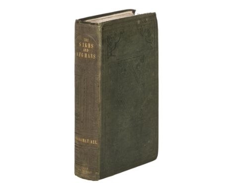
Ali (Shahamat). The Sikhs and Afghans, in Connexion with India and Persia, immediately before and after the Death of Ranjeet Singh: from the Journal of an Expedition to Kabul, through the Panjab and the Khaibar Pass, London: John Murray, 1847, xxii 550 pp., half-title, 12 pp. advertisements to rear, binder's ticket (Edmond & Remnants) to rear pastedown, 24 pp. W. H. Allen and Co. catalogue ('Elementary Works in the Oriental Languages') tipped to front free endpaper, bookplate of the Cavalry Club to front pastedown, front inner hinge cracked and slightly tender, damp-stain to head of rear inner hinge not affecting text-block, original vertical-ribbed green cloth, spine lettered in gilt, spine and covers panelled in blind, spine slightly sunned and rolled, front joint worn at head and with 1cm tear to foot, a few pale marks to sides, corners a little bumped and worn (upper fore corner of front board slightly more so), large 12mo, together with: Andrew (Sir William Patrick). Memoir on the Euphrates Valley Route to India; with Official Correspondence and Maps, 1st edition, London: Wm. H. Allen & Co., 1857, pp. xvi 267 [1] 7, 3 pp. advertisements to front, half-title, 2 large folding colour maps, each map closed tear to stub (just touching image in first instance), bookplate of the Cavalry Club, original green cloth gilt, spine slightly darkened, tips bumped, a bright copy, 8vo, [India]. Recollections of the Deccan, with Miscellaneous Sketches and Letters. By an Officer of Cavalry, 1st edition, Calcutta: G. H. Huttmann, Bengal Military Orphan Press, 1838, pp. [8] 1-119, lithographic plan (slightly damp-stained), light variable damp-staining to margins, inscribed 'Mrs Crawford, with the author's very kindest regards' on the initial blank, bookplate of the Cavalry Club, contemporary calf by Martin of Calcutta, loss to head of spine and spine-label, front board damp-stained and near-detached, 8vo in 4s (24.8 x 15.2 cm), Bellew (Henry Walter). The Races of Afghanistan, being a Brief Account of the Principal Nations inhabitating that Country, 1st edition, Calcutta: Thacker, Spink, and Co., 1880, pp. [3]-124, 2+38 pp. advertisements to rear, no half-title (unknown if called for), edges brittle with resulting loss to upper fore corners of first 10 leaves not affecting text, a few other nicks, bookplate removed from front pastedown, rear free endpaper pasted to pastedown, original pictorial cloth, wear to extremities, head of spine torn, rear board mottled, 8voQty: (4)NOTESShahamat Ali's work is notably uncommon. It was first published in 1846; it is unknown whether copies dated 1847 represent a second issue or a second edition, but as copies dated 1846 are paginated xviii 550 it appears likely that only the preliminaries were reset. Library Hub cites two locations for the third work (Recollections of the Deccan: British Library and Oxford).
![Lothian (John). Lothian's County Atlas of Scotland, 2 parts in 1 volume, 2nd edition, Edinburgh: J. Lothian, 1826 [i.e. 1830]](https://cdn.globalauctionplatform.com/097ee6b6-2081-432a-b7f6-ac6000a6c3d8/7bb887c9-ee3b-4e79-8cb0-ac60011745ff/468x382.jpg)
Lothian (John). Lothian's County Atlas of Scotland, 2 parts in 1 volume, 2nd edition, Edinburgh: J. Lothian, 1826 [i.e. 1830], 4;2;[2] pp., engraved frontispiece (dated 1829), 2 engraved title-pages (dated 1826 and 1829), 41 hand-coloured engraved maps on 39 sheets (all dated 1830 except the final map, 'Modern Scotland', dated 1827; 2 of the maps double-page: 'Scotland under the Romans' and 'Scotland in the Fifteenth Century'), toned throughout, light offsetting, small perforation from map 27 to end, contemporary half calf, rebacked with original spine laid down, original green paper label to front cover, rubbed overall, 4to (29.2 x 23 cm)Qty: (1)NOTESTHE DAVID WILSON LIBRARY PART III: SCOTLAND, HIGHLANDS & ISLANDS Chubb Scotland XXVIIIa (p. 386). Chubb records this rare work under the title Atlas of Modern Scotland, and may not have seen a copy of either the first edition (1826) or the present edition, as he describes only the the third edition of 1838, in his view 'a neatly prepared and clearly printed atlas'. The second part contains seven historical maps and a 'Map of Modern Scotland'; the part-title indicates that the work was issued coloured, as here, and uncoloured.

Austen & Co. (publishers). A Safety Guide for those contemplating a trip on the Sea of Matrimony, Chicago, 1906, a used postcard (with a 1908 post stamp) containing a photolithographic folding allegorical map, presented in folding boards with a tongue and slit fastening, slight soiling to upper boards, 215 x 275 mm, together with Matrimonial postcards. Four used postcards of maps relating to marriage, early 20th century, including Knight Bros. (publishers). Chart of Betrothal Bay shewing the Male Route to Churchdoor, tinted lithographic postcard in the form of an allegorical map of the route to marriage, 90 x 140 mm, together with Nister (Edward). Love's Empire, chromolithographic American postcard in the form of an allegorical island of love in the shape of a heart, 90 x 140 mm, with another copy, plus Heine (Heinrich). Geographische Liebes Rathsel, photolithographic German postcard in the form of an allegorical map of the journey to marriage, 90 x 140 mmQty: (5)
Folio Society. The World Crisis, 5 volumes, 2007, The Second World War, 6 volumes, 2000, by Winston S. Churchill, A Secret Pilgrimage to Mecca and Medina, 2004, colour folding map to the front, The Source of the Nile..., 1993, black & white folding map to the front, both by Richard F. Burton, Sowing The Wind, The Seeds of Conflict in the Middle East, by John Keay, 2016, Italian Journey 1786-1788, by J. W. Goethe, 2010, together with 47 further volumes of Folio Society publications, all military & travel reference, all original cloth in slipcases, G/VG, 8voQty: (62)
![[Moll, Herman]. Geographia Classica: The Geography of the Ancients so far describ'd as it is contain'd in the Greek and Latin](https://cdn.globalauctionplatform.com/097ee6b6-2081-432a-b7f6-ac6000a6c3d8/d8b43982-8667-4388-bb69-ac600117094f/468x382.jpg)
[Moll, Herman]. Geographia Classica: The Geography of the Ancients so far describ'd as it is contain'd in the Greek and Latin Classicks, in Twenty-nine Maps of the Old World ... a collection long wanted, and now publish'd for the use of schools, 2nd edition, London: printed for C. Browne, 1717, 29 double-page engraved maps (one folding), 4 with near contemporary hand-colouring, title printed in red & black, some dampstaining at head and fore-edges, map 15 with tear to lower margin (just affecting map border), map 16 close-trimmed at foot and fore-edges (affecting border & 1 place name), final map with 2 tiny losses, front free endpaper deficient, contemporary red quarter morocco, worn, small 4to, together with: Butler (Samuel), An Atlas of Ancient Geography, London: Longman & Co., circa 1839, 22 double-page engraved maps (complete), all but one hand-coloured in outline, engraved calligraphic title, 16pp. publisher's catalogue at rear dated August 1839, a few minor spots or marks, 4 maps with some pale brown staining, 1 map with closed tear to lower corner (affecting map border), front free endpaper with ink manuscript ownership name, dated 1840, contemporary red half morocco, worn, front cover with original engraved paper label, small 4to, with 7 others similar (some defective), including Walker's Universal Atlas for the use of schools, 1823, and Maps and Plans Illustrative of Livy, published J. Vincent, Oxford, circa 1850?Qty: (9)NOTESFirst item: ESTC T222277.
![* Berkshire. Speed (John), Barkshire Described, 1st edition, John Sudbury & George Humble, [1611], hand coloured engraved](https://cdn.globalauctionplatform.com/097ee6b6-2081-432a-b7f6-ac6000a6c3d8/3a334309-f8c7-42f3-ab3a-ac600117c15e/468x382.jpg)
Marshall (William). The Rural Economy of the West of England: including Devonshire; and parts of Somersetshire, Dorsetshire, and Cornwall. Together with Minutes in Practice, 2 volumes, London: G. Nicol, G.G. and J. Robinson, and J. Debrett, 1796, folding engraved map frontispiece to volume 1 with offsetting and spotting to title. contemporary calf, gilt decorated spines, light cracking to joints, 8vo, together with: Nott (John), Of the Hotwell Waters, near Bristol, 3rd edition, Bristol: printed by Emery and Adams, [1793], ink stamp to title and first leaf of text, final leaf torn to upper and lower blank corners and repaired, light dust-soiling and occasional spotting, ink stamp to front free blank, early 19th century calf, title in gilt to spine and upper board, slight wear to extremities, slim 8vo, [Incledon, Henry], Donations of Peter Blundell, [Founder] and other Benefactors to the Free Grammar School at Tiverton, Exeter: E. Grigg, [1792], two engraved plates, one folding pedigree, numerous annotations, tipped in letter to front pastedown from Benjamin Incledon dated 25 Oct 1793 and inscriptions to front free endpaper including that of Benjamin Incledon to John Rolle 1793, contemporary panelled calf with blind rollwork decoration, rebacked, recent red morocco title label to spine, 8vo, Roper (Ida M.), The Monumental Effigies of Gloucestershire and Bristol, Privately printed for the Author, Gloucester: Henry Osborne, 1931, monochrome frontispiece and plates, top edge gilt, contemporary dark blue half morocco, thick 8vo (limited edition 9/100, signed by the author)Qty: (5)

Somerset. Speed (John), Somerset-Shire described and into Hundreds devided. With the plott of the famous and most wholsom waters and citie of Bathe, John Overton, 1700 or later, engraved map with early hand colouring, an inset town plan of Bath, slight spotting, laid on later card, 375 x 505 mmQty: (1)NOTESThe map is dated 1668. John Overton acquired John Speed's plates from Christopher Browne in about 1695, so the published date is misleading. Overton made some alterations to the plates, primarily adding Overton's roads to the maps, however, on this example, the map remains un-altered without the addition of roads.
![Farrer (James). Notice of Runic Inscriptions discovered during Recent Excavations in the Orkneys, 1st edition, [Edinburgh]: p](https://cdn.globalauctionplatform.com/097ee6b6-2081-432a-b7f6-ac6000a6c3d8/9e5642dc-bfdc-4d20-9760-ac6001173955/468x382.jpg)
Farrer (James). Notice of Runic Inscriptions discovered during Recent Excavations in the Orkneys, 1st edition, [Edinburgh]: printed for private circulation, 1862, half-title, 13 lithographic plates (some in colours or double-page), spotting, inscribed 'with the authors comps' on the half-title, original green pictorial cloth gilt, wear to spine-ends, 4to, together with: Reid (John T.). Pictures from the Orkney Islands, 1st edition, Edinburgh: David Douglas, 1881, 53 lithographic plates, maps, gilt edges, original red cloth gilt, spine faded, headcap frayed, 4to, one of 500 copies only, Orkney Antiquarian Society. Proceedings of the Orkney Antiquarian Society, volumes 1-15 in 2, Kirkwall: printed at the Orcadian office [-at the Kirkwall Press, the Orcadian office], 1923-39, maps, halftone plates and text-illustrations (collation unknown), original wrappers for each volume bound in, spotting to edges, modern tan half calf, 4to (25 x 19.5 cm), Hossack (Buckham Hugh). Kirkwall in the Orkneys, 1st edition, Kirkwall: William Peace & Son, 1900, 6 halftone plates including frontispiece, 4 colour maps, numerous text illustrations (many full-page), gilt edges, contemporary red half calf, 4to (25.7 x 20 cm), Mooney (John, editor). Charters and Other Records of the City and Royal Burch of Kirkwall, 1st edition, [Aberdeen]: published for the provost, magistrates and councillors, [1952], gilt lithographic armorial frontispiece, 10 halftone plates, folding map, 5 signatures to front free endpaper (provost, town clerk, two bailies, and the honorary treasurer of Orkney) below David Wilson's pencilled note 'Presented to Wm John Heddle - to whom the book is dedicated', town clerk's compliments slip tipped to front pastedown, original presentation binding of red sheep gilt, partly faded, 4to (24.6 x 17.5 cm), and 15 others, all Orkney-related, 19th and 20th century, including Smith, A Collection of Armorials of the County of Orkney, 1st edition, 1902, Mitchell, Mesehowe, 1st edition, 1863 (2 copies), and others, 4toQty: (23)NOTESTHE DAVID WILSON LIBRARY PART III: SCOTLAND, HIGHLANDS & ISLANDS This set represents a complete run of the Proceedings of the Orkney Antiquarian Society.

Scotland. Blaeu (Johannes), Glottiana Praefectura Inferior cum Baronia Glascuensi. The Nether Warde of Clyds-Dail and Baronie of Glasco, Amsterdam, circa 1654, engraved map with contemporary outline colouring, some staining, 390 x 535 mm, French text on verso, mounted, together with Praefetura Kircubriensis quae Gallovidiae Maxime Orientalis pars est. The Steuartrie of Kircubright, The most Easterlie part of Galloway, Amsterdam, [1654 - 62], engraved map with contemporary outline colouring, 425 x 545 mm, slight overall toning, no text on verso, mounted, with Sterlinensis Praefectura Sterlin-Shyr, Amsterdam, circa 1654, engraved map with contemporary outline colouring, large decorative cartouche, 415 x 525 mm, Latin text on verso, plus Levinia vice Comitatus. The Province of Lennox, called the Shyre of Dun-Britton, Amsterdam, circa 1654, engraved map with contemporary outline colouring, one small hole affecting image, 395 x 530 mm, Latin text on verso, mountedQty: (4)
-
109182 item(s)/page