We found 109198 price guide item(s) matching your search

Refine your search

Year

Filter by Price Range
  • List
  • Grid
  • 109198 item(s)
    /page

Lot 680

A 17th century road map engraving by John Ogleby, London to Poole, showing the stretch from Alresford to Poole and then Lymington to Southampton 34 x 45 cm to/w Charte von Africa by F L Gussefeld, Nurnberg 1797, impression size 50 x 56 cm and a Victorian steel engraving of Africa by J Rapkin, 25 x 32 cm (3 - all framed and glazed) surfaces (under glass) appear dirty/dusty, water stains to some margins, not affecting the images 

Lot 681

A 17th century John Speed/Joducus Hondius county map, 'Dorsetshyre', 39 x 51 cm, mounted framed and glazed

Lot 464

Antiquarian and Later Books - Doyle (Sir Arthur Conan), Sherlock Holmes: The Complete Long Stories, first edition thus, London: John Murray, 1929, contemporary red cloth, 8vo, (1); Travel, Drummond (Henry, F.R.S.E., F.G.S.), Tropical Africa, With Map and Illustrations, London: Hodder and Stoughton, 1888, contemporary red cloth gilt, 8vo, (1); Ornithology, Johns (Rev. C.A.), British Birds in their Haunts, tenth edition, London: 1899, illustrated blue cloth, 8vo, (1); Waugh (Edwin), Lancashire Sketches, First Series, Manchester: John Heywood, [n.d.], contemporary cloth, 8vo, (1); Cochrane's English Essayists [...], Edinburgh: 1880, contemporary cloth, all-edges gilt, 8vo, (1); Black's Guide to Dorsetshire, tenth edition, 1879, green cloth, 12mo, (1); 1900 Racing Calendar, contemporary calf binding, 8vo, (1); Bunyan's Pilgrim's Progress, 19th century illustrated copy, pictorial cloth as issued, 8vo, (1); Punch 1911, contemporary cloth; further Victorian and later illustrated periodicals; folios of sheet music, mainly Beethoven; later 20th century hardback fiction and non-fiction, including John le Carré first edition, business reference; children's, including Enid Blyton and Harry Potter; large quantity

Lot 232

Collection of vintage toys, to include scratch built hand carved and painted wooden horses, huntsmen, fox and dogs, a vintage stuffed toy dog, an English Counties Jig-Saw Map, and collection of vintage dolls (qty) Black horse 14cm high.One rider lacking arm. Some hounds missing legs and others have been re-glued.Chips and other small losses.

Lot 67

German porcelain headed doll with sleeping eyes (loose) marked B 3. 50cm, Map of England with its Canals and Railways, case daguerreotype of a Victorian gentleman, and a silver dish set with a Churchill crown, cased, (4)

Lot 432

A map of Somersetshire by Robert Morden, and an Edwardian mahogany 30-hour mantel clock (2)

Lot 215

An Antique map of the Hundreds of Middleton alias Milton and of Tenham, 18th century, 37cm x 48cm

Lot 323

Bonzo dogs print and a vintage map of Lancashire. Not available for in-house P&P

Lot 527

A COLLECTION OF FOLDING MAPS including Bartholomew's half-inch contoured maps and a 1935 land utilisation map for East Kent

Lot 528

JOHN CARY: MAP OF DORSETSHIRE, framed 30 x 35cms overall

Lot 529

JODOCUS HONDIUS: MAP OF LINCOLNSHIRE, 1610 with text to the back, framed 43 x 56cms overall

Lot 530

ROBERT MORDEN'S MAP OF THE NORTH RIDING OF YORKSHIRE, framed 60 x 65cms overall

Lot 531

ROBERTUS GORDONIUS: AN ANTIQUARIAN MAP OF SCOTLAND, framed with text verso visible through the paper, 54 x 66cms overall

Lot 603

After Henry George Gawthorn (1879-1941)/Knaresborough, It's Quicker by Rail/lithographic poster, 29cm x 37.5cm/and two others, The Coronation and a map [3]

Lot 75

An old Oar together with an old school chart / world map (2)

Lot 121

17 th century German tinted map of Bavaria in glazed frame

Lot 51

H W Ras Manuscript map in ink and watercolour, laid paper with Turkey Mill Kent and Britinannia watermark, tanning along top edge, some light soiling, top and side edges attached to backing, 6cm closed tear halfway down left edge, 4cm closed tear next to main title, framedFull title: Kaart Van De Bermuda Eilanden: Gedachtenis Aam Mijn Verblyf Op De Bermuda's In De Anglo-Boer Wars 1899 - 190[0]The decorative, but poignant map shows the locations of the various POW camps as well as distances to various cities.33,5 by 42cm

Lot 61

Gerardo & Leonardo Valk AFRICA - MAURO PERUSSA OCEANO NILOQUE ADMOTA TEPENTI Amsterdam: Gerardo & Leonardo Valck, (c1720) Copperplate engraving, hand coloured, centerfold, foxing, paper loss in top corner of margin, soiling and pencilled notes in margins; verso: blank, paint show through, four tape repairs along bottom and right margin, tape repair along centerfold and an 8cm repair diagonally from centerfold in lower third of map49 by 59,7cmLITERATURENorwich #75

Lot 62

Copperplate engraving, hand coloured, centerfold, paper watermark, tanning under window mount; bottom left: A PARIS chez l’Auteur sur le Quai de l’Horloge; bottom right: avec Privilege Janvier 1708; both top corners “197” in ink; verso: blank, paint show through, tanning along margins and centerfold, all margins with small tears repaired with tape, pencilled notes, top of map attached to window mount with masking tape, upper corners with “196” and “198” respectively in ink, framed48,2 by 61,5cmLITERATURETooley p.72

Lot 75

Abraham Ortelius AFRICAE TABULA NOVA Antwerp: De l'Imprimerie Plantienne, (1570) [1598]Copperplate engraving, hand coloured, centerfold, two crossed arrows watermark, a few unobtrusive worm holes; verso: one page of French text titled “AFRICQUE” and numbered “4”, tanning on margin behind window mount, minimal foxing, right edge curled, a 5cm tear repaired with tape, map attached to mount with two short pieces of tape at top and bottom, framed37 by 50cmLITERATURENorwich #10Tooley p.88Van der Broeke, M., Cartographica Neerlandica Background for Ortelius Map No. 8, accessed 21 September 2020: www.orteliusmaps.com/book/ort8.html

Lot 214

Three Chinese pictures inc. map of Malacca

Lot 1604

Two hooves converted into ink stands together with a further hoof with veil and one other, with a silk map of occupied Continental Europe (5)

Lot 2145

A nest of three graduated reproduction occasional tables with brass fittings/frames and glazed tops enclosing map prints

Lot 241

Isaac Taylor (British 1730-1807) - An 18th century black and white engraved map of the county of Gloucester in six sections, each sheet size 46.5 x 61cm approx, further inscribed Ross and dated March 10th 1777, unframed (6)

Lot 2699

A contemporary occasional table of rectangular form, raised on ebonised frame work with brass banded borders enclosing a reproduction map of the old world after Henry Hondius 1630, 105cm x 72cm x 42cm

Lot 254

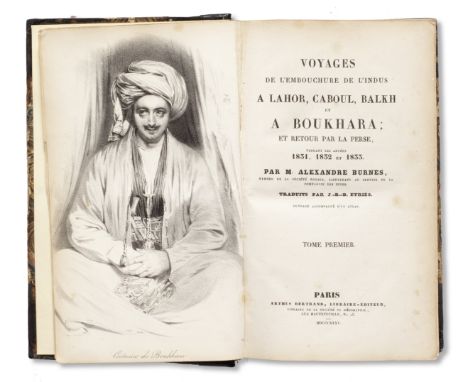
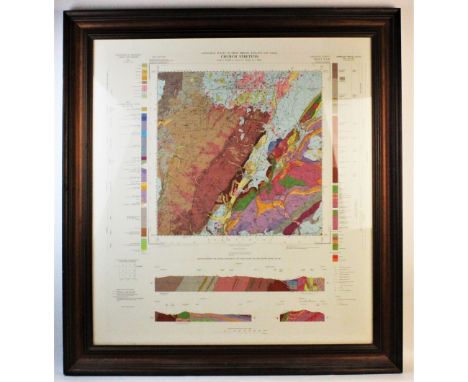
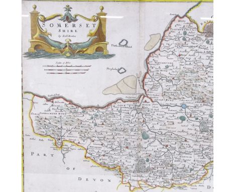
A highly unusual copy of the first French edition of Sir Alexander Burnes' account of his journey through Sikh territories and to Bokhara, Voyages de l'embouchure de l'Indus a Lahor, Caboul, Balkh et a Boukhara et retour par la Perse, both volumes bound by his brother in leather from the boots worn by Burnes in making his journey Paris, Arthus Bertrand, 1835three volumes bound in two, translated by Jean-Baptiste Benoit Eyriès, half-title and lithographed portrait of Burnes after Daniel Maclise in vol. I, inscribed by Dr James Burnes on front endpaper, vol. III with eleven numbered plates including one (folding) of the Bamiyan Buddhas, and one large folding map, contemporary half diced calf, marbled covers, stamped gilt spines with insignia and motto of the King's Own Royal Lancaster Regiment, or perhaps the Inniskilling Fusiliers 212 x 140 mm.(2)Footnotes:ProvenanceDr James Burnes, brother of Sir Alexander Burnes, the author (inscription in front endpaper of vol. I).Library of the King's Own Royal Lancaster Regiment, alternatively that of the Inniskilling Fusiliers (insignia on spines).The remarkable inscription of Dr James Burnes in the first volume reads as follows:Memo -This book is bound in the leather of the boots with which my brother Sir Alex performed his journey into Bokhara.James BurnesSir Alexander Burnes ('Bokhara Burnes'), British traveller, explorer, writer and participant in the 'Great Game' in Central Asia and the borders of India, was born in 1805. He joined the Bombay Infantry in 1821. He devoted himself to the study of local languages and was, while still an ensign, selected for the post of regimental interpreter. In 1829, he was transferred to the Political Department as Assistant to the Political Resident in Kutch. In 1831, he travelled to Lahore in charge of English horses including a team of carthorses, four mares and a stallion, sent by the King of England as presents for Maharajah Ranjit Singh. The actual objective of Burnes' mission was to survey the River Indus and assess the power and resources of the Amirs of Sindh, then being threatened by the Maharajah.In October of that year, Burnes organised the first meeting of Maharaja Ranjit Singh with a serving commander of British forces in India, Lord William Bentinck, the Governor-General. The event was marked by the Maharaja's open display of the Koh-i-Noor, which he presented for free inspection to the British attendees. (The jewel would of course eventually come into the possession of the British Royal Family and was later set in Queen Alexandra's crown).As with other European visitors (such as Emily Eden), it was Ranjit Singh himself who seems to have made the greatest impression, as in the following passage in the French edition offered here:...et il doit y avoir un contraste prodigieux entre son esprit et son corps. Il a perdu un oeil, il est marque de la petite verole, et sa taille ne depasse surement pas cinq pieds trois pouces. Il est entierement exempt de pompe et de faste; mais l'attitude respectueuse de sa cour est remarquable; personne ne prenait la parole sans en avoir obtenu la permission par un signe, quoique la presse ressemblat plutot a celle d'un bazar qu'a celle des apartemens du plus puissant des princes indigenes de cette contree dans les temps actuels (p. 149).Burnes described Maharajah Ranjit Singh's habits and government, his passion for his horses, troops and horse artillery, and dancing girls. In January 1832, Burnes visited Lahore again to solicit facilities from the Maharajah for travel through the Punjab to Afghanistan, Central Asia, Balkh and Bokhara.It is not too fanciful, therefore, to think that the binding of the present volumes derive from the very boots worn by Burnes when he met Ranjit Singh, and other Sikh notables, in Lahore. Afghanistan, however, and the routes between North India and central Asia were the key to the 'Great Game', in which the southward ambitions of Tsarist Russia threatened to collide with the British northward-looking desire to protect India, primarily, and by extension Persia. In 1831, travelling in disguise, Burnes surveyed the route through Kabul to Bokhara - and hence to Central Asia and the borders of Russia - and produced the first detailed accounts of Afghan politics.In the following years his travels continued through Afghanistan across the Hindu Kush to Bukhara (in what now is modern Uzbekistan) and Persia.The narrative which Burnes published on his visit to England in 1834 added immensely to contemporary knowledge of these countries and was one of the most popular books of its time. The first edition earned the author £800, an enormous sum in those days. Much feted, his services were recognised not only by the Royal Geographical Society of London, but also the French Geographical Society. Burnes was also elected a Fellow of the Royal Society the same year.Soon after his return to India in 1835 he was appointed to the court of Sindh to secure a treaty for the navigation of the Indus. In the following year he undertook a political mission to Dost Mohammed Khan in Kabul. This was to be the road to his own end, and the start of years of disastrous British interventions in Afghanistan.On the restoration of Shah Shuja in 1839, Burnes became Political Agent at Kabul, and was knighted by Queen Victoria on 6 August 1839. A posthumous account of Burnes' later adventures was published in 1842 under the title of Travels into Bokhara, being an Account of a Journey from India to Cabool (recently republished).Shah Shuja was a British puppet, and Burnes regarded him as the wrong man for the job. Shah Shuja was loathed by the Afghan people, and so were the British. There was a breakdown of order in Kabul, partly brought about by high taxation and food prices, but mainly by this antagonism. Burnes and a group of British officers became the focus of the anger of a mob of Afghans. One officer was shot dead, another hacked to death. Burnes (said to have tied a black cloth around his face so he could not see where the blows came from) walked into the crowd and was beaten to death.This lot is subject to the following lot symbols: •• Zero rated for VAT, no VAT will be added to the Hammer Price or the Buyer's Premium.For further information on this lot please visit Bonhams.com
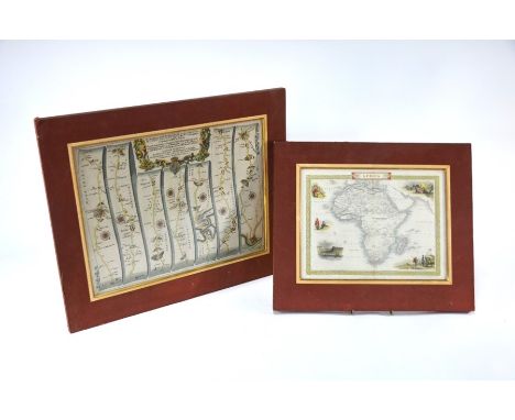
Lot 8

An illustrated leaf from a manuscript of the Risalah Hatamiyyah of Kamal al-Din Husayn Kashefi Sabzavari, depicting a story concerning the famous generosity of the Arab prince Hatam-e Tai Persia, 16th Centurygouache and gold on paper, three lines of text written in nasta'liq script in black ink, with a heading in red ink, inner margins ruled in colours and gold, recto ten lines of text leaf 193 x 135 mm.Footnotes:ProvenanceDr Thomas Ewart Marston (1905-1984), curator of Mediaeval and Renaissance Literature art at Yale University Library.Minna Marston, his wife, and thence by descent.Dr. Marston was elected trustee of the Yale University Library Association in 1933 and was the curator of Mediaeval and Renaissance literature at the library until his retirement in 1972. He had a BA from Yale and and MA and PhD from Harvard University. He was the author of Britain's Imperial Role in the Red Sea Area: 1800-1878 and co-author of The Vineland Map and the Tartar Relation.The Risalah Hatamiyyah was composed in AH 891/AD 1486-87. It is apparently the only book written entirely about Hatam-e Tai, an Arab prince and a poet of the pre-Islamic era, known for his great generosity.The illustration here relates to this virtue. A man was sent by the King of Yemen to find Hatam, kill him, bring his head to the ruler and so receive an enormous reward. Not knowing Hatam and where he was, he met a young man whom he told of his mission, asked to help him find Hatam, and in return to get part of the reward. The young man - who happens to be Hatam himself - offers his head so that the king gets his wishes and the messenger his big reward. The messenger kisses Hatam, goes to the King of Yemen and tells him of Hatam's generosity. The king of Yemen acknowledges Hatam's generosity as exceeding anyone else's.Important Notice to BuyersSome countries e.g., the US, prohibit or restrict the purchase by its citizens (wherever located) and/or the import of certain types of Iranian-origin works. As a convenience to buyers, Bonhams has marked with the symbol R all lots of Iranian (Persian) origin. It is each buyer's responsibility to ensure that they do not bid or import a lot in contravention of the sanctions or trade embargoes that apply to them.This lot is subject to the following lot symbols: * R* VAT on imported items at a preferential rate of 5% on Hammer Price and the prevailing rate on Buyer's Premium.R This lot is subject to import restrictions when shipped to the United States.For further information on this lot please visit Bonhams.com

Lot 7

An illustrated leaf from a manuscript of the Sharaf-nameh, the fifth book of Nizami's Khamsa, depicting Dara in battle with Iskandar's army Persia, 16th Centurygouache and gold on paper, recto four lines of text written in nasta'liq script in black ink in four columns, outer border decorated with scrolling stylised floral motifs in gold, verso 23 lines of text, inner margins ruled in colours and gold leaf 250 x 147 mm.Footnotes:ProvenanceDr Thomas Ewart Marston (1905-1984), curator of Mediaeval and Renaissance Literature art at Yale University Library.Minna Marston, his wife, and thence by descent.Dr. Marston was elected trustee of the Yale University Library Association in 1933 and was the curator of Mediaeval and Renaissance literature at the library until his retirement in 1972. He had a BA from Yale and and MA and PhD from Harvard University. He was the author of Britain's Imperial Role in the Red Sea Area: 1800-1878 and co-author of The Vineland Map and the Tartar Relation.Important Notice to BuyersSome countries e.g., the US, prohibit or restrict the purchase by its citizens (wherever located) and/or the import of certain types of Iranian-origin works. As a convenience to buyers, Bonhams has marked with the symbol R all lots of Iranian (Persian) origin. It is each buyer's responsibility to ensure that they do not bid or import a lot in contravention of the sanctions or trade embargoes that apply to them.This lot is subject to the following lot symbols: * R* VAT on imported items at a preferential rate of 5% on Hammer Price and the prevailing rate on Buyer's Premium.R This lot is subject to import restrictions when shipped to the United States.For further information on this lot please visit Bonhams.com

Lot 6

A leaf from an illustrated manuscript, depicting a hunting scene with wild beasts Persia, 16th Centurygouache and gold on paper, five lines of text written in nasta'liq text in two columns, inner margins ruled in colours and gold, outer border with stylised clouds and foliage in gold leaf 226 x 141 mm.Footnotes:ProvenanceDr Thomas Ewart Marston (1905-1984), curator of Mediaeval and Renaissance Literature art at Yale University Library.Minna Marston, his wife, and thence by descent.Dr. Marston was elected trustee of the Yale University Library Association in 1933 and was the curator of Mediaeval and Renaissance literature at the library until his retirement in 1972. He had a BA from Yale and and MA and PhD from Harvard University. He was the author of Britain's Imperial Role in the Red Sea Area: 1800-1878 and co-author of The Vineland Map and the Tartar Relation.The text has not been identified, but the leaf appears to come from the same manuscript as lots 4 and 5. It may be from one of the interpolated parts of the Shahnama.Important Notice to BuyersSome countries e.g., the US, prohibit or restrict the purchase by its citizens (wherever located) and/or the import of certain types of Iranian-origin works. As a convenience to buyers, Bonhams has marked with the symbol R all lots of Iranian (Persian) origin. It is each buyer's responsibility to ensure that they do not bid or import a lot in contravention of the sanctions or trade embargoes that apply to them.This lot is subject to the following lot symbols: * R* VAT on imported items at a preferential rate of 5% on Hammer Price and the prevailing rate on Buyer's Premium.R This lot is subject to import restrictions when shipped to the United States.For further information on this lot please visit Bonhams.com

Lot 163

PRINT OF A MAP OF A LAGOON

Lot 239

A Whites map of Suffolk showing all the railways and names of stations

Lot 457

A gilt framed print depicting the Prophet Jeremiah; a white framed wall mirror and a gilt framed map

Lot 596

After Day & Son, pair of colour prints, View of Hong Kong and the Town of Victoria, overall 23 x 78cm and a map of China

Lot 609

An 18th century Dutch map of Holland 1733, 60 x 51cm

Lot 518

A SOUTHDOWN MOTOR SERVICES LTD OFFICIAL TIME TABLE BOOK, 1957-1958, with a route map

Lot 601

Local History and Topography. An Inventory of the Historical Monuments in Westmorland. London: HMSO, 1936. Original cloth, worn. With map in rear pocket. With; Richardson, J. - Furness Past and Present. Barrow: 1880. Volume I only. (2)

Lot 602

Antiquarian. Local History. West, Thomas - A Guide to the Lakes, &c. London: 1784, 3rd edition. With folding map. Poor binding. With; The Antiquities of Furness. Ulverston: George Ashburner, 1805. Bound in marbled paper covers. (2)

Lot 606

Travel and related. Small selection, includes; Willoughby, H. - Australian Pictures. London: 1886. Original cloth; Palen, L. S. (trans.) - The Fire of Desert Folk. London: 1926. Original cloth; Du Chaillu, Paul B. - The Land of the Midnight Sun. London: 1899 reprint. Lacks map. And; 3 others. (6)

Lot 607

Local History. An Inventory of the Historical Monuments in Westmorland. 1936 - 1st edition. Original cloth, illustrated including folding map in rear pocket. (1)

Lot 641

Cumberland & Westmorland. Local history, a selection. Collingwood, W. G. & Smith, A. Reginald - The Lake Counties. 1932, limited edition no.306/350, signed, in dust wrapper; Lysons, D. & S. - Magna Britannia: Volume IV Cumberland. Map and plates, in modern green cloth; etc. (6)

Lot 642

Lake District. Wordsworth, William - A Guide Through the District of the Lakes in the North of England. Kendal: Hudson & Nicholson. 1835, 5th edition. Folding map. With; Sayer's History of Westmorland. Kendal: W. Sayer, 1847. Two volumes. Frontispieces and map (loose + damaged). Cloth re-bind. (3)

Lot 681

Wainwright. A Map of the County of Westmorland. Second edition, not coloured. Framed and glazed. (1)

Lot 682

Wainwright. A Map of the County of Westmorland. Second edition, coloured. Framed and glazed. (1)

Lot 683

Wainwright. A Map of the County of Westmorland. First edition, coloured. Framed and glazed. (1)

Lot 686

Map. West Indies: Thomas Jefferys, c.1750's. Later hand colouring. Depicting countries and colonial interests, details show noteable islands, bays, towns, rivers, mountains, etc. Repair to damage on left margin. Framed and glazed. (1) Measurments: Map - 30cm x 19cm   Frame - 46cm x 36cm

Lot 687

Rolled Maps. A selection of Lake District OS map sheets. Large format, includes areas surrounding Hawkshead, Coniston, Newby Bridge/Fell Foot, etc. (6)

Lot 1163

A box of 1960's magazines, a map of the USSR and Raphael Tuck & /Sons Dressing Doll Story Book **PLEASE NOTE THIS LOT IS NOT ELIGIBLE FOR POSTING AND PACKING**

Lot 390

An amusing dry cleaning colour poster and a large map.

Lot 458

A small part hand coloured map of "Pembroke".

Lot 780

A large relief moulded map of the world.

Lot 371

A collection of books on pirates, buccaneers and seafaring, comprising: GERHARD (P), PIRATES ON THE WEST COAST OF NEW SPAIN 1575-1742, 1st edition, red cloth boards, gilt title to spine, illustrated frontispiece, five maps and four monochrome plates, The Arthur H. Clark Company, California 1960, WOODES (R) and LESLIE (R.C), LIFE ABOARD A BRITISH PRIVATEER IN THE TIME OF QUEEN ANNE, 1st edition, decorated blue cloth boards, pull-out map frontispiece, four monochrome plates and further line illustrations, Chapman And Hall Ltd, London 1894, ESQUEMELING (J), THE BUCCANEERS OF AMERICA, red cloth boards with gilt title and illustration to spine, engraved frontispiece of Sir Henry Morgan, with six further engraved plates and a map of the South Sea and coasts of America, George Allen & Company Ltd, London 1911, DAMER POWELL (J.W), BRISTOL PRIVATEERS AND SHIPS OF WAR, 1st edition, J.W. Arrowsmith Ltd, Bristol 1930, ERLEIGH (VISCOUNT), THE SOUTH SEA BUBBLE, 1st edition, cream cloth boards, Peter Davis Limited, 1933, WYCHERLEY (G), BUCCANEERS OF THE PACIFIC, Neptune Edition, Rich & Cowan Ltd, London 1935, and MASEFIELD (J) (Ed), A SAILOR'S GARLAND, Methuen & Co Ltd, London 1942 (7)

Lot 397

Eman. (Emanuel) Bowen (1694-1767), Hand coloured engraving on paper, 'An accurate map of Shropshire divided into its hundreds', 'Sold by John Hinton at the King's Arms in St Paul's church yard London 1751', 61.5cm x 81.5cm overall, Framed and glazed

Lot 399

A 1:25,000 scale geological map of Church Stretton, published by the Geological Survey Of Great Britain (England and Wales) in 1968, showing the geological terrain above and below the surface of the area using colour codes and various scales, framed and glazed, 88.5cm x 82cm overall, with four further geological maps of Shrewsbury, Wenlock Edge & Surrounds, Ironbridge and Wolverhampton, and Bridgnorth and Dudley ? Wrens? Nest, each with colour coding, scales and further details verso, in matching frames, each 37cm x 52cm overall, and a large vintage map of Sussex, framed and glazed, 75cm x 104cm overall (6)

Lot 141

A framed and glazed Robert Morden map of the North Riding of Yorkshire, overall H48 x L54.5cm, together with three later maps, including a copy of John Speed map of The North and East Ridins of Yorkshire. - Condition Report

Lot 74

The Illustrated London News, Vol XLVI Jan to June 1865, printed & published by George C Leighton 198 Strand London, together with two folding linen backed maps, Map of Scotland, and Map of England & Wales, published by The Chart Publishing Company St John Street Oxford, each in two parts, with Alphabetical Index, and index and Route Guide to Map. - Condition Report

Lot 1024

A framed and glazed map "Back Street Garboldisham 1883", 28cm x 39cm

Lot 1075

An autumn Publishing World Map wall chart with frame, 55cm x 77cm

Lot 1284

John Cary, hand coloured part map of S.W. England and South Wales, 1794, folding, backed onto linen

Lot 1387

Robert Morden: 'Kent', engraved hand coloured map. C.1695 or later, framed and glazed, (a/f), 38cm x 65cm

Loading...Loading...
  • 109198 item(s)
    /page

Recently Viewed Lots